


Royal Scribe
Royal Scribe
About
- Username
- Royal Scribe
- Joined
- Visits
- 9,537
- Last Active
- Roles
- Member
- Points
- 3,353
- Birthday
- February 5, 1968
- Location
- San Francisco, California
- Website
- https://legacy.drivethrurpg.com/browse/pub/31814/Royal-Scribe-Imaginarium
- Real Name
- Kevin
- Rank
- Mapmaker
- Badges
- 16
Latest Images


Reactions
-
[WIP] Wizard's Tower - Interior
Been working on the other floors, but I still have several more floors to do. (And this is the Wizard's Tower that I am calling the "small" tower, in contrast to the other one I started that is more like a Council of Wizards' fortress. This "small" tower will still be at least eight stories above ground (though some of them are smaller and one is really just a bell tower), and at least three underground (though one is just the sewers)).
From the main entrance on the third floor, you can go up or down through the spiral staircase in northern wall. Let's go down to the second floor.
Second Floor
This is primarily the main dining area for the wizard and his or her guests. In addition for seating for 15, the dining hall has two fireplaces, with the smaller one used to heat up kettles of tea and other food. This room also has a sink connected to the water system, a separate pipe that runs through the room (for more water in the floors above), several cabinets for dinnerware sets and table linens, and a statue of a female wizard -- a former owner, perhaps the tower's creator. Outside the room, a long table in the hall is used by the kitchen staff and footmen to assemble the food before bringing it in for guests. Unlike the third floor, where the arrow slits were off of a corridor and the rooms had no external windows, on the second floor the arrow slits also allow for daylight to enter the rooms.
Beside that room in the southwest corner of the tower is a cozy, wedge-shaped room with a balcony overlooking the great stairs a floor below. From here, the wizard's family can lean over a railing to greet guests on the landing. This floor also has a restroom, and a small, gated "back door" with a sign directing visitors to continue up another flight to the main entrance.

First Floor
The first floor is at the same level as the main landing with the extra wide stairs, but for added security, there is no doorway there, nor windows or even arrow slits. This floor has a spacious kitchen with a stove and a marble countertop, along with a dining nook for the tower's staff. There are also two rooms equipped with crystals that magically emit cold energy. The one on the south side is called the Cold Room and the one north of it is called the Ice Room, as it is cold enough to freeze water. (Basically, they're magical versions of a walk-in refrigerator and freezer.) The final room on this floor, other than the WC, is a furnace room with a massive furnace for heating water and a great tub of hot water for doing laundry. The room is hot enough that even on rainy days, wet laundry will dry on clotheslines strung up in this room.
(True story: my family did not have electricity for eight years of my childhood and one of my daily chores was to build a fire in an outdoor fireplace like this one to heat water than ran through it in pipes. We also had not one but two outhouses -- fancy!)

Haven't started on the basement yet, so for now, let's go back upstairs.
Fourth Floor
Reversing direction, we can climb up to the fourth floor, the lowest level to have proper windows instead of arrow slits. This floor has the main lounge for entertaining overnight guests, where folks can socialize, play cards and other games, or enjoy a performance from a traveling bard or a minstrel from the nearby village. This room even has a wet bar! I should put in some chairs and couches, though.
This floor also has a chapel (looks like I forgot to put in pews). It also has a WC with a window to the outside, a room for bathing, and two oddly-shaped guest bedrooms.

Working on the fifth floor now, which will include use of one of the two balconies you can see poking out on the south side.
Here are the FCW files if anyone wants to customize them for their own gameplay, using the same licensing terms as the Atlas (where this will someday find a home).


-
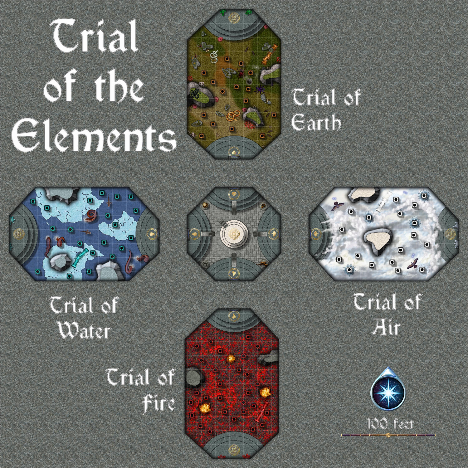
[WIP] Community Atlas: Kumarikandam - SE Tiantang Region
The final map, the Trial of the Elements. This can be linked to from two places: the center of the labyrinth in the Huo Yu Bing Caverns, and the dais in the Ritual Room of the basement of the Zhao Guang Si Temple.
No toggles. The dais in the middle of the central room can link back to the basement of the Zhao Guang Si Temple.
Description
The Trial of the Elements
Final Initiation for the Monks of Zhao Guang Si
Apprentices studying the Path of the Morning Glow at the Zhao Guang Si monastery have two final initiation tests required to graduate and take their place among the ranks of the other monks.
Students must first pass the Trial of Fire and Ice within the Huo Yu Bing Caverns to access the teleportation portal that will take them here, to the Trial of the Elements. That first trial might result in the student recovering a blue shard that protects them from cold damage, and a red shard that protects them from fire damage. While neither is required to pass the trials, both will make it easier to pass both the Trial of Fire and Ice as well as the Trial of the Elements.
The Central Room
After completing the Labyrinth of Fire and Ice in the Huo Yu Bing Caverns, initiates will be teleported into this octagonal room, where they will appear on a dais of white marble in the center of the room.
At the compass points of this room are four daises made of gray marble. Each has a brass circle with runes inscribed on it, with a different sigil for each. On the eastern dais, the sigil is of a cloud with a lightning bold. On the southern dais, the sigil is of a ball of flames. On the western dais, the sigil shows a drop of water. On the northern dais, the sigil is of a cut gemstone.
There are four statues along the remaining four walls of the octagonal room. The statue on the northeastern wall is of a crouching cat. On the southeastern wall, the statue is of a winged person. The statue on the southwestern wall is of a serpent, and in the northwestern wall, it is of a horned skull.
When anyone first appears on the central dais, the horned skull statue in the northwestern corner will speak and say:
“Welcome! Before the Trial of the Elements, present thyself before each of us for a battle of wills.”
The initiate may approach the statues in any order. For the willpower battle, the Game Master will roll a d20+5. The initiate then rolls a d20 and adds their Wisdom bonus. If the initiate has the highest score, they win the willpower battle and achieve a magical effect for the next 24 hours. If they fail, there is no harmful effect, but they do not achieve the magical bonus and may not try again.
The following gifts are available:
• Cat Statue (NE corner): The initiate benefits from a Spider Climb spell for the next 24 hours.
• Winged Person (SE corner): The initiate benefits from a Feather Fall spell for the next 24 hours.
• Serpent (SW corner): The initiate is immune to poison and diseases for the next 24 hours.
• Horned Skull (NW corner): The initiate is immune to electrical damage for the next 24 hours.
Once they have completed a battle of wills with each statue, the horned skull statue will speak again:
“Present thyself on any dais to begin that trial of the elements.”
Initiates may embark on the trials in any order.
The Trial of Air
When the student reaches the top of the dais on the eastern wall, a teleportation portal on the wall will glow with a purplish light, and the horned skull statue will speak:
“If thou art ready to begin the Trial of Air, step now through the portal.”
Stepping through the portal deposits the traveler on a dais on the eastern wall of a long room that is 160 feet by 100 feet. The room is filled with clouds that cover the floor, making it impossible to see how far down the floor is. Ornate columns carved to look like clouds sprinkle the room.
Those wishing to cross the room must make a standing long jump from one column to the next. As gravity is magically lighter here, the initiate can move a full foot for each point of Strength they have. When they land on the next pillar, they must make a Dexterity check against moderate difficulty to avoid slipping off and falling.
The floor is 30 feet below, and anyone who slips will suffer falling damage unless they can fly or are protected by the Feather Fall spell. Climbing back up a pillar requires a Strength check of moderate difficulty. Success is automatic if they are under the effect of Spider Climb or a similar ability.
Each pillar has a one in six chance of delivering a bolt of lightning that deals 1d10 electrical damage unless they are immune to electricity. In addition, the room is protected by a pair of creatures that magically manifest as a flying creature, which may be hawks, harpies, small air elementals, or similar creatures.
There are a few outcrops in the room. Landing on one does not require a Dexterity check to avoid slipping off, and they do not deliver electrical damage.
Visitors are permitted to use any magical, trained, or innate abilities to travel across the room, including flying if they can do so.
If they reach the dais on the eastern wall, two milky white crystals are on either side of a teleportation portal. Retrieving a shard from either crystal will activate the teleportation portal, allowing them to return to the central room and embark on the next trial.
The Trial of Fire
When the student reaches the top of the dais on the southern wall, a teleportation portal on the wall will glow with a purplish light, and the horned skull statue will speak:
“If thou art ready to begin the Trial of Fire, step now through the portal.”
Stepping through the portal deposits the traveler on a dais on the northern wall of a long room that is 160 feet by 100 feet. The floor is covered with molten lava, with ornate pillars rising ten feet above the lava.
Those wishing to cross the room must make a standing long jump from one column to the next. As gravity is magically lighter here, the initiate can move a full foot for each point of Strength they have. When they land on the next pillar, they must make a Dexterity check against moderate difficulty to avoid slipping off and falling.
If they slip, they fall ten feet into the lava, taking 2d6 damage from the lava each turn that they remain in it, unless they are immune to fire damage, such as possessing a red shard from the Trial of Fire and Ice. Climbing back up a pillar requires a Dexterity check of moderate difficulty unless they benefit from the Spider Climb spell or have a similar ability.
There are a few outcrops in the room. Landing on one does not require a Dexterity check to avoid slipping off.
The room is protected by three small fire elementals who will attack at random and without coordination.
Visitors are permitted to use any magical, trained, or innate abilities to travel across the room, including flying if they can do so.
If they reach the dais on the southern wall, two bright red crystals are on either side of a teleportation portal. Retrieving a shard from either crystal will activate the teleportation portal, allowing them to return to the central room and embark on the next trial.
The Trial of Water
When the student reaches the top of the dais on the western wall, a teleportation portal on the wall will glow with a purplish light, and the horned skull statue will speak:
“If thou art ready to begin the Trial of Water, step now through the portal.”
Stepping through the portal deposits the traveler on a dais on the eastern wall of a long room that is 160 feet by 100 feet. The floor is covered with icy water, with ornate pillars rising ten feet above the water.
Those wishing to cross the room must make a standing long jump from one column to the next. As gravity is magically lighter here, the initiate can move a full foot for each point of Strength they have. When they land on the next pillar, they must make a Dexterity check against moderate difficulty to avoid slipping off and falling.
If they slip, they fall ten feet into the cold water. For each turn they remain in the water, they must make a Constitution check of moderate difficulty. If they fail, they take 1d6 damage unless they are immune to fire damage, such as possessing a blue shard from the Trial of Fire and Ice. Climbing back up a pillar requires a Dexterity check of moderate difficulty unless they benefit from the Spider Climb spell or have a similar ability.
A pair of sharks patrol the waters and may attack anyone who falls in. In addition, six tentacles rise above the waves throughout the room and may attack anyone on a pillar.
There are a few outcrops in the room. Landing on one does not require a Dexterity check to avoid slipping off, and the tentacles mysteriously will not attack anyone on an outcrop.
Visitors are permitted to use any magical, trained, or innate abilities to travel across the room, including flying if they can do so.
If they reach the dais on the western wall, two bright turquoise crystals are on either side of a teleportation portal. Retrieving a shard from either crystal will activate the teleportation portal, allowing them to return to the central room and embark on the next trial.
The Trial of Earth
When the student reaches the top of the dais on the northern wall, a teleportation portal on the wall will glow with a purplish light, and the horned skull statue will speak:
“If thou art ready to begin the Trial of Earth, step now through the portal.”
Stepping through the portal deposits the traveler on a dais on the southern wall of a long room that is 160 feet by 100 feet. The floor is covered with grass, but anyone can easily see serpents, rats, and giant spiders throughout the room.
If they slip, they fall ten feet onto the ground, taking falling damage unless they can fly or are protected by a spell or ability like Feather Fall. Climbing back up a pillar requires a Dexterity check of moderate difficulty unless they benefit from the Spider Climb spell or have a similar ability.
While on the ground, they will be attacked each turn by a snake, rat, or spider. The snakes and spiders are venomous, and the rats are diseased. An attack that causes damage requires the victim to making a Saving Throw against poison unless immune to poison through a magical effect or ability. These creatures will not attack anyone on a pillar.
There are a few outcrops in the room. Landing on one does not require a Dexterity check to avoid slipping off. Each outcrop has one snake on it, but new snakes will not climb up if the snake on them is slain.
Visitors are permitted to use any magical, trained, or innate abilities to travel across the room, including flying if they can do so.
If they reach the dais on the northern wall, two bright green crystals are on either side of a teleportation portal. Retrieving a shard from either crystal will activate the teleportation portal, allowing them to return to the central room and embark on the next trial.
Graduation
If an initiate has retrieved a shard from each of the four Trial of the Elements rooms, the horned skull statue will speak, saying:
“Congratulations, graduate. You have passed the Trial of the Elements. Stand on the dais in the center of the room with all four shards, and you will be transported home.”
Doing so will result in being teleported to dais in the Ritual Room in the basement of the Temple of Zhao Guang Si.

-
[WIP] Community Atlas: Kumarikandam - SE Tiantang Region
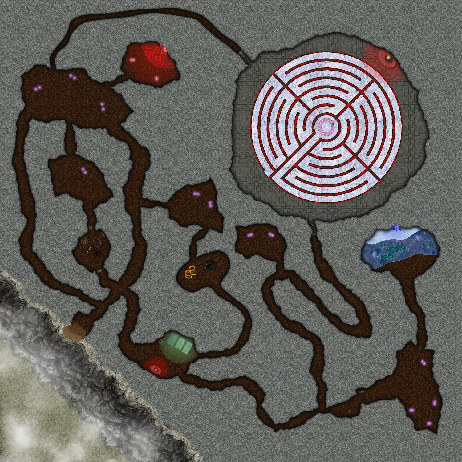
This is the Huo Yu Bing Caverns, which is accessed though a cave entrance on the cliffs of the main map:
No toggles. The teleportation portal in the center of the labyrinth can be linked to the Trial of the Elements (coming next):
Description
Huo Yu Bing Caverns
The Trial of Fire and Ice
Whether drawn by desperation or greed or malice, prospective monks risk everything, even their very lives, to study the mysterious Path of the Morning Glow at the Zhao Guang Si monastery. There, apprentices learn the art of killing.
They climb cliffs without ropes, traverse fields filled with deadly traps, and duel to exhaustion, all to strengthen their bodies and reflexes. They are taught to hide emotions, manipulate the minds of their targets, and plan assassinations with surgical precision. And they study ancient grimoires containing magics that grant temporary invisibility, silencing voices, and even cursing the senses. These spells demand sacrifices, often blood, making the price of power high
Those who survive the training – and most do not – must pass two deadly trials to graduate and join the ranks of the the Zhao Guang Si monks.
The first of these trials is the Trial of Fire and Ice, which they must complete before embarking on the Trial of the Elements.
A Perilous Climb
To reach the entrance of the Huo Yu Bing Caverns, apprentices must scale the side of a cliff without benefit of rope or other tools. Those who fall may make the attempt another day…if they survive. Many do not.
Haunted and Infested Caverns
The caverns are infested with giant spiders and venomous snakes, but they are not the only peril in the caverns. When trainees perish in the caverns, their remains are not retrieved. Instead, a baleful magic infuses their bones while worms feast on their softer tissues. In about a month, those bones will reanimate, and these skeletons will attack the next trainee to brave the caverns. In addition, the spirits of those who die in the caverns are bound to them, haunting as a Spector and attacking the living who dare to enter.
The Cave of Fire
In one room within the caverns, a red crystal is embedded on the opposite wall of the room. A pool of lava blocks access to the crystal, but that is not the room’s only perils. A pair of lesser demons guard the room and will attack anyone who enters.
Anyone who reaches the crystal can easily take a shard from it. This shard will grant the possessor immunity to damage from fire and heat. Although apprentices can complete the trials without the shard, possessing one will make their efforts considerably easier.
The Cave of Ice
In the Cave of Ice, a semi-frozen lake blocks access to a blue crystal embedded in the far wall. A pair of ice devils also guard the room. Visitors who reach the blue crystal can take a shard from it, which will provide immunity to cold damage. A trainee can survive the trials without the shard but possessing it will make their task easier.
The Labyrinth of Fire and Ice
At the end of the caverns, a spacious room holds a labyrinth traced on the floor. While monks at other monasteries use these labyrinths as a meditation tool, slowly walking the path in reflective contemplation, this labyrinth is a device of torture, pain, and possible death. The path of the labyrinth is made of ice, while its edges are magically lined with hot lava.
At the far end of the room, a statue of a horned skull will speak in an archaic but understandable tongue to anyone who enters, saying:
“Welcome, visitor. Art thou ready to brave the Labyrinth of Fire and Ice?”
If answered in the affirmative, the statue will continue:
“Step then at the beginning of the labyrinth and follow every step of the path to the center. Lest thee attempt to bypass the path, remember that the portal will only open for those who have followed my instructions and traversed the path.”
If the apprentice attempts to bypass the path by stepping over its edges or flying over the labyrinth, the statue will again say:
“The portal will only open for those who have followed my instructions and traversed the path.”
If someone reaches the center by flying, leaping, or otherwise avoiding walking along the path, the tele
Every turn, those walking along the path must make a Constitution saving throw. Those who fail with take 1d6 cold damage from unless they have immunity to cold damage, such as by possessing a shard of the blue crystal. In addition, each round they must also make a Dexterity saving throw. Those who fail slip on the ice enough to touch the hot lava, taking 1d6 fire damage unless immune to fire damage, such as from possessing a shard from the red crystal.
Those who perish while traversing the labyrinth will ignite from the heat of the lava. Over the course of an hour, even their bones will have been reduced to ash. For those who survive and make it to the center, a teleportation portal will activate and magically transport them to the Trial of the Elements.
-
[WIP] Community Atlas: Kumarikandam - SE Tiantang Region
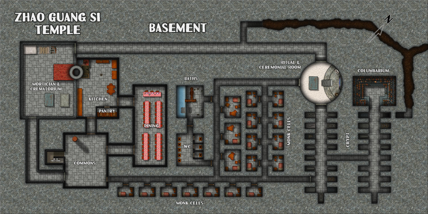
Here is the basement of the temple:
Toggle: SECRET layer to show/hide the secret passage escape route.
Description
Although trainees and junior monks live in barracks on the monastery’s grounds, the more senior monks have quarters in the temple’s basement, where trainees may join them for the final meal of the day. The basement also includes a kitchen and a crematorium, which share a chimney that rises outside the temple on its northwest side. Senior monks are interred in sarcophagi in the temple’s crypts when they pass away, but trainees and junior monks are cremated, with their cremains interred in urns in a columbarium.
A circular room that connects to the crypts is used for funeral services and other rituals. There is a teleportation portal here that the senior monks can use to access the Zhao Guang Si’s Trials of the Elements. Trainees who survive those trials will be teleported where upon completion of all four trials.
-
[WIP] Community Atlas: Kumarikandam - SE Tiantang Region
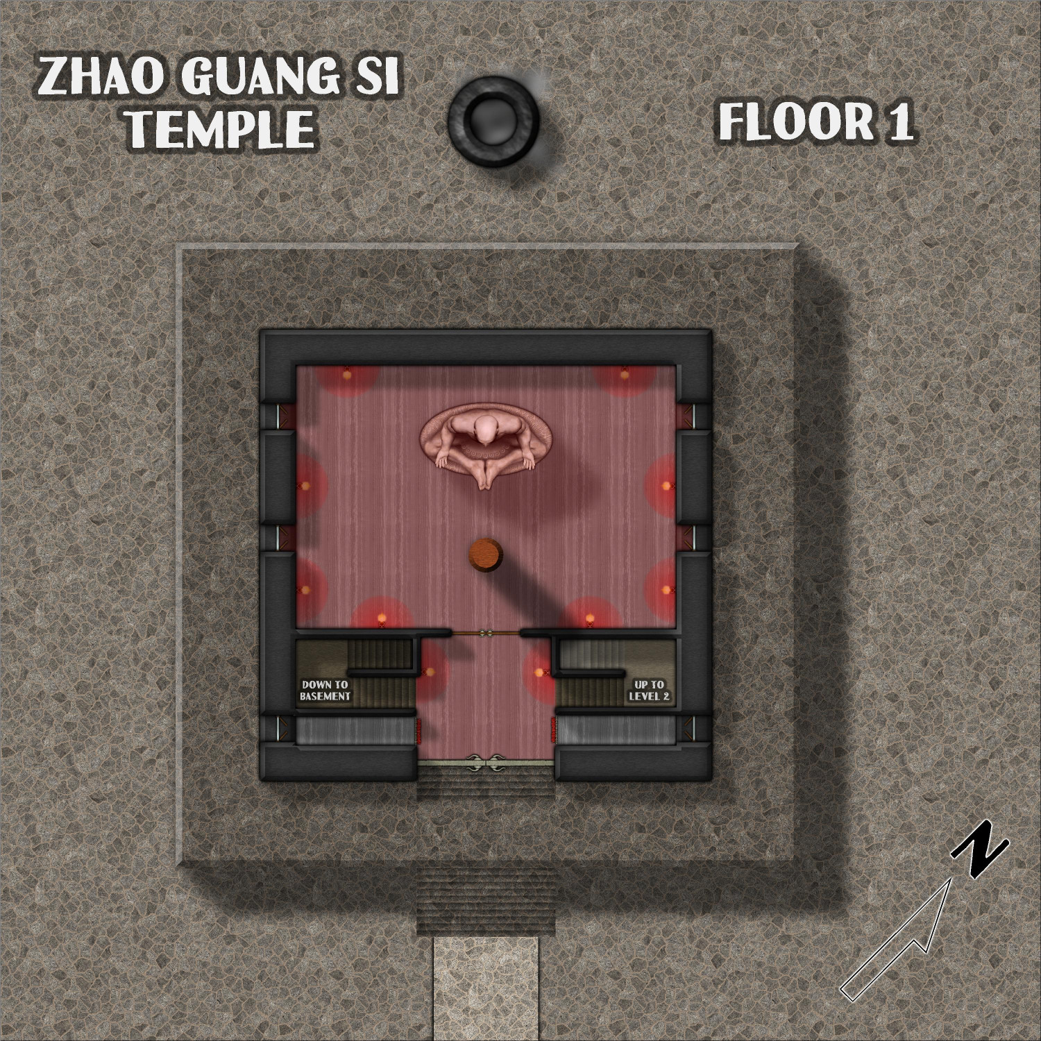
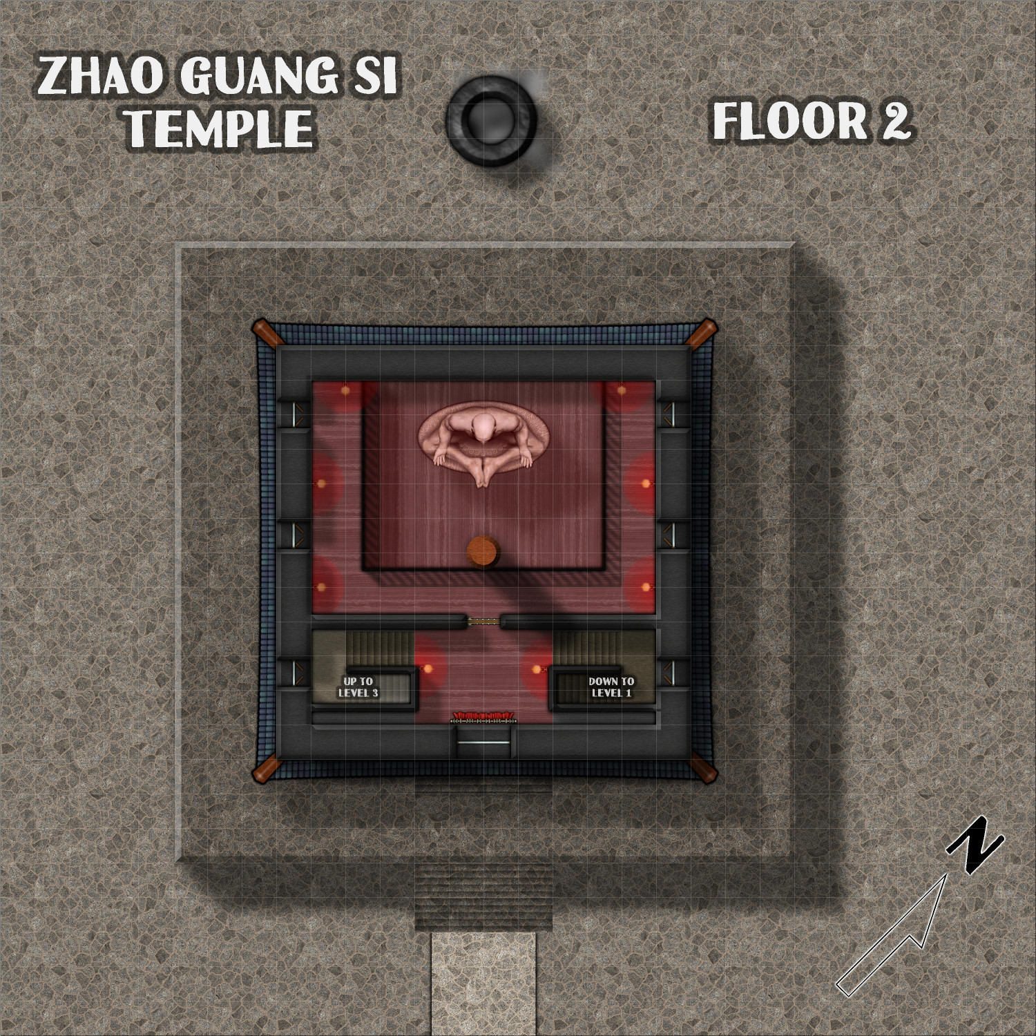
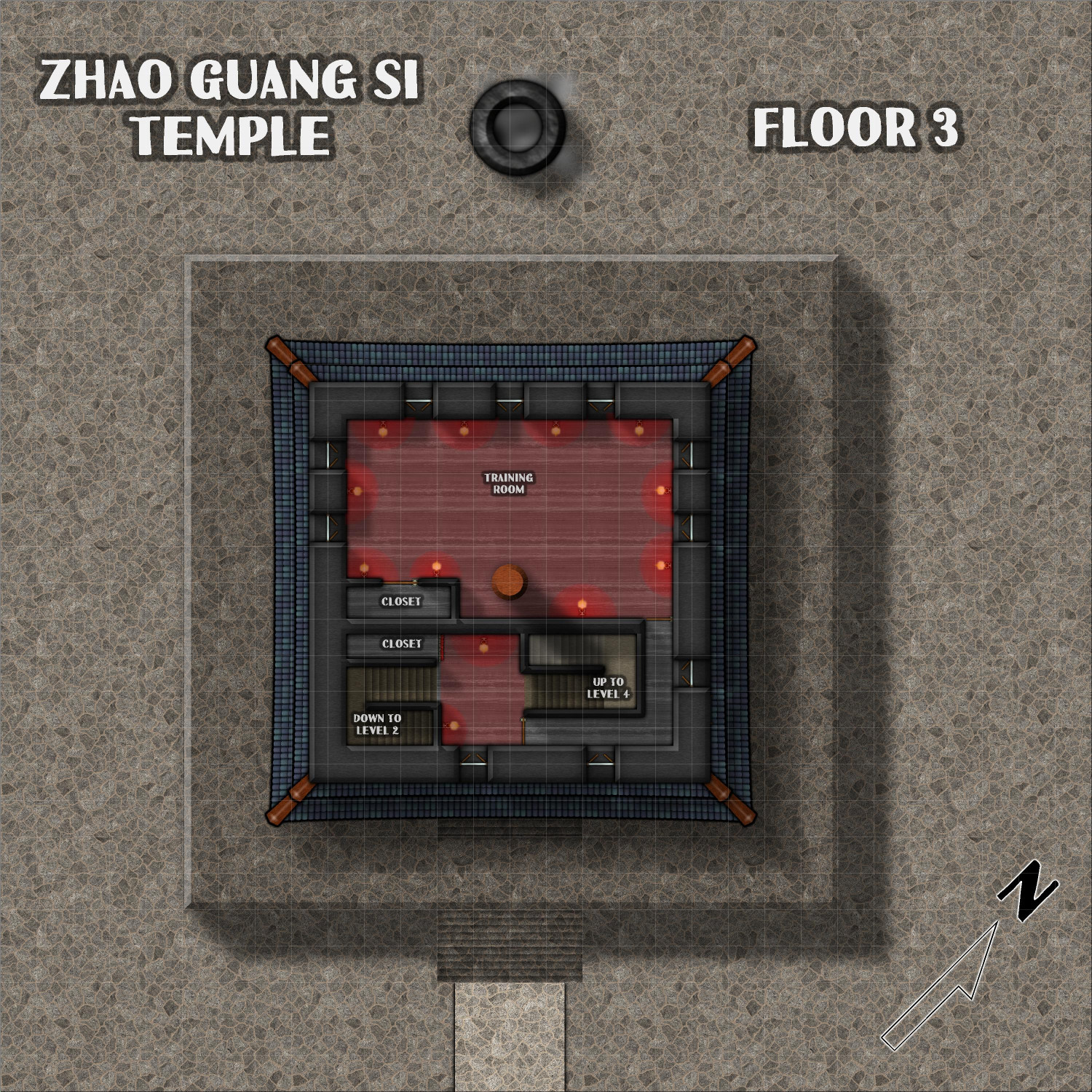
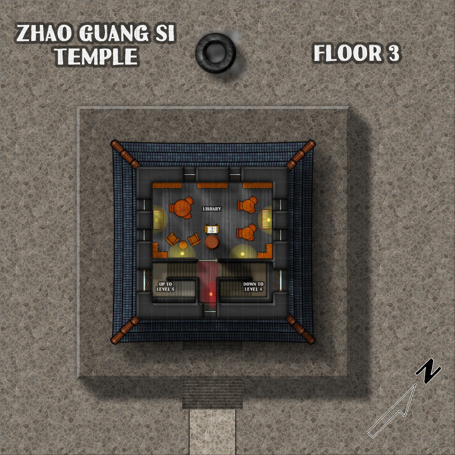
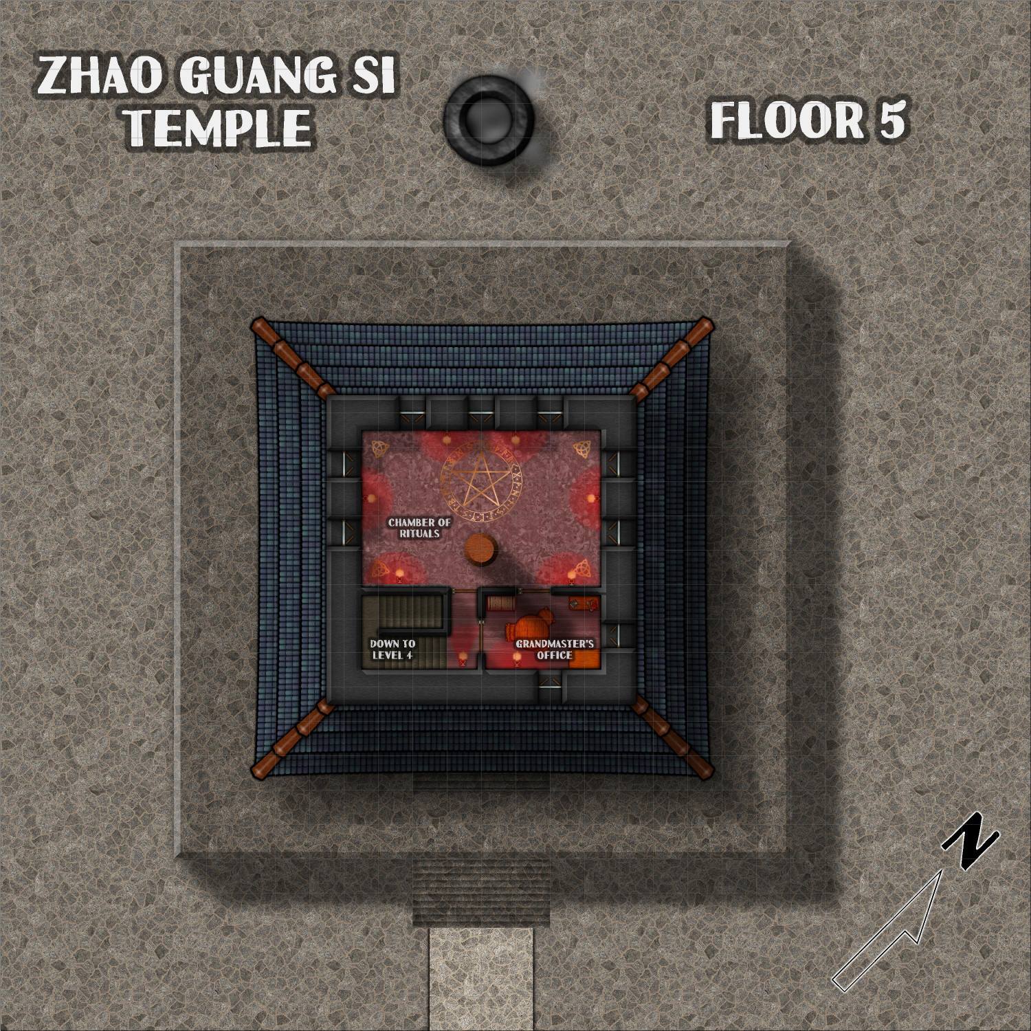
Here are the five above-ground levels of the Zhao Guang Si Temple (the basement will be separate).
Toggle: LIGHTING layer to show/hide the red glow throughout most of the temple.
Description
At the Zhao Guang Si monastery, a five-story pagoda temple rises through the mists and clouds. The wooden walls are painted with a dark lacquer, and the lanterns are covered with a red gauze that gives the interior an ominous red glow. A center oaken beam rises through every floor, providing structural support for the temple.
First Floor
The first floor is dominated by a 40-foot statue of a man sitting cross-legged. Although there are four windows, two on each wall flanking the statue, they generally remain closed and shuttered so that the only light comes from the red lanterns.
Second Floor
This floor consists primarily of a balcony overlooking the temple floor below. The statue is large enough to still be higher than the monks standing on the balcony. As with the other windows throughout the temple, the windows here are generally shuttered.
Third Floor
Except for a few closets for storing equipment, this floor primarily consists of a training room where trainees can spar with each other until they drop from exhaustion.
Fourth Floor
The library on this floor is the only room where the lanterns are not shrouded in red gauze, and the windows may remain open to allow for reading by daylight.
Fifth Floor
The grandmaster has an office on this floor, but much of the floor is dedicated to the Chamber of Rituals, where it is said that senior monks may perform dark magic to enhance their abilities.

