


Royal Scribe
Royal Scribe
About
- Username
- Royal Scribe
- Joined
- Visits
- 9,537
- Last Active
- Roles
- Member
- Points
- 3,353
- Birthday
- February 5, 1968
- Location
- San Francisco, California
- Website
- https://legacy.drivethrurpg.com/browse/pub/31814/Royal-Scribe-Imaginarium
- Real Name
- Kevin
- Rank
- Mapmaker
- Badges
- 16
Latest Images


Reactions
-
Advice for planning a major city?
I am in the early stages of planning to design a major city for the Atlas, and I wanted to get advice from those here who have done big cities. This is for the city of Khemtufu, which is in Doriant - Gold Coast - Eknapata Desert. My goal is to provide a home for the Temple of Fah that I designed nearly a year ago, so that it can finally have a home in the Atlas. (Here are the discussion threads for the exterior and interior maps of the temple.)
I am planning to use SS5 Cities of Schley as the foundation. It has good Middle Eastern-style symbols as well as a great variety of symbols in general, and I might supplement with some assets from SS4 Dungeons of Schley. I also plan to also use domes from the City Domes annual, but that's probably it. I am planning to create canals using the Color Key cutout approach since Schley's fills don't meet up as seamlessly as fills from other annuals sometimes do. That will allow a nicer connection between the canals and the river, and will make it easier to add to the canals as I go along.
For those of you who have designed big cities before, I would love to hear your tips and strategies for how to approach it.
Size
My thought is that this will be a major city, definitely the largest in the portion of the Eknapata Desert that spills into the Gold Coast region. What are your thoughts about how geographically large it should be before it becomes unwieldy?
I looked up some comparable cities from the medieval period, picking the year 1000 A.D. for comparison. In 1000 AD, Cairo had an estimated population of 135,000 and a geographic size of "a few square kilometers" (according to Google AI). Constantinople had a population of about 500,000 people and a geographic size of 14 square kilometers (5.4 square miles, or 2.3 x 2.3. miles). I am thinking that Khemtufu would have a population closer to 50,000 to 100,000 people if that seems feasible.
I tried checking the Atlas for other cities to get a sense of a good scale for a large city. Sue & Lorelei's City of Sanctuary was 15,000 x 15,000 feet, IIRC, making it about 2.8 x 2.8 miles, or about 5.7 square miles. Quenten's Dun Fingolfin was 10,000 x 6,000 (feet, I think?). His city of Torstan is 1,364 x 1,364 meters (4,475 x 4,475 feet).
Does a map of 10,000 x 10,000 feet (1.9 x 1.9 miles) seem feasible? Any tips or recommendations on scaling? I realize that buildings would be very small, but zooming into neighborhoods would show more detail.
Mapping Strategies
I assume I will end up turning off sheet effects a lot of the time while I'm working to reduce refresh lag.
In a previous thread that I cannot find at the moment, someone suggested creating layers for each neighborhood, and then putting buildings on a neighborhood layer rather than a layer denoting its type of business. That way you can hide every neighborhood you aren't working on to also reduce system strain.
(Related: I am making a list of potential neighborhood names, though that will flow better once the basic layout of the city is done. Things like Garden District for a posh neighborhood, Northgate for the neighborhood closest to the northern entrance, Eastern Addition for a newer expansion on the eastern side, Oldtown for a central area that was the original town before it gradually expanded to be a city, etc. Thoughts and recommendations welcome.)
In his second Big City Project tutorial (around the 35 minute mark) Ralf creating a building-block tool for creating temporary blocks of buildings as placeholders until building symbols can be placed.
For those of you who have designed big cities, what strategies like these do you recommend? What did you do -- or what to you wish you knew to do before you started?
Advice?
Any advice or recommendations you have, especially things I should plan for at the outside (like setting up layers and sheets) is most appreciated.

-
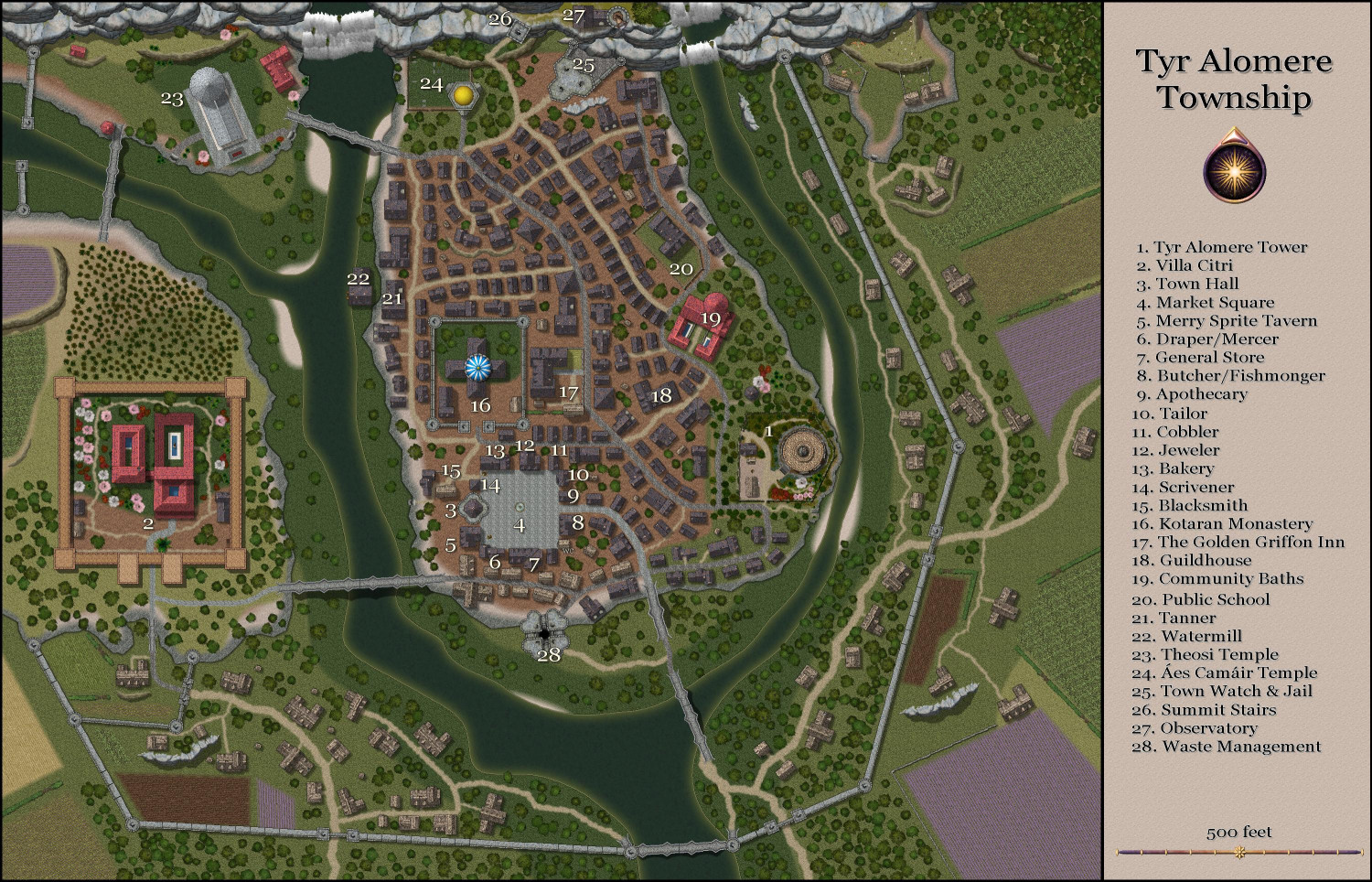
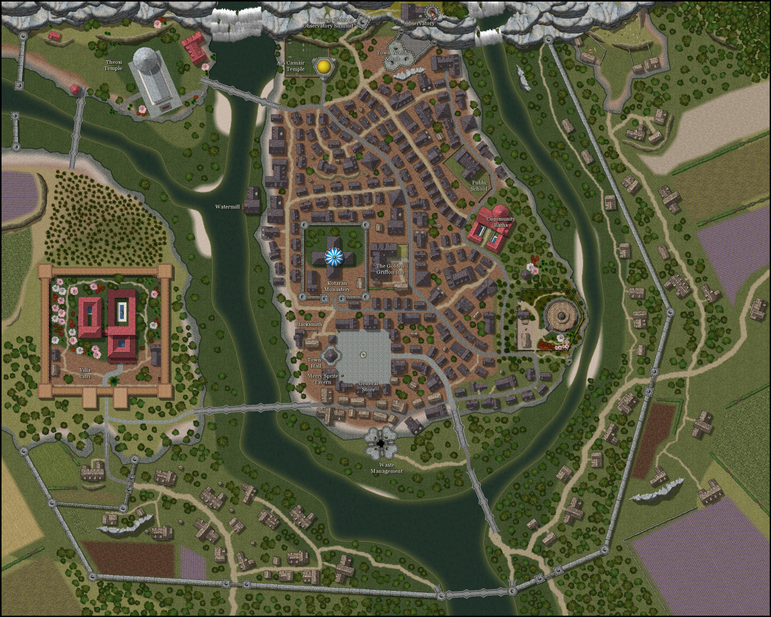
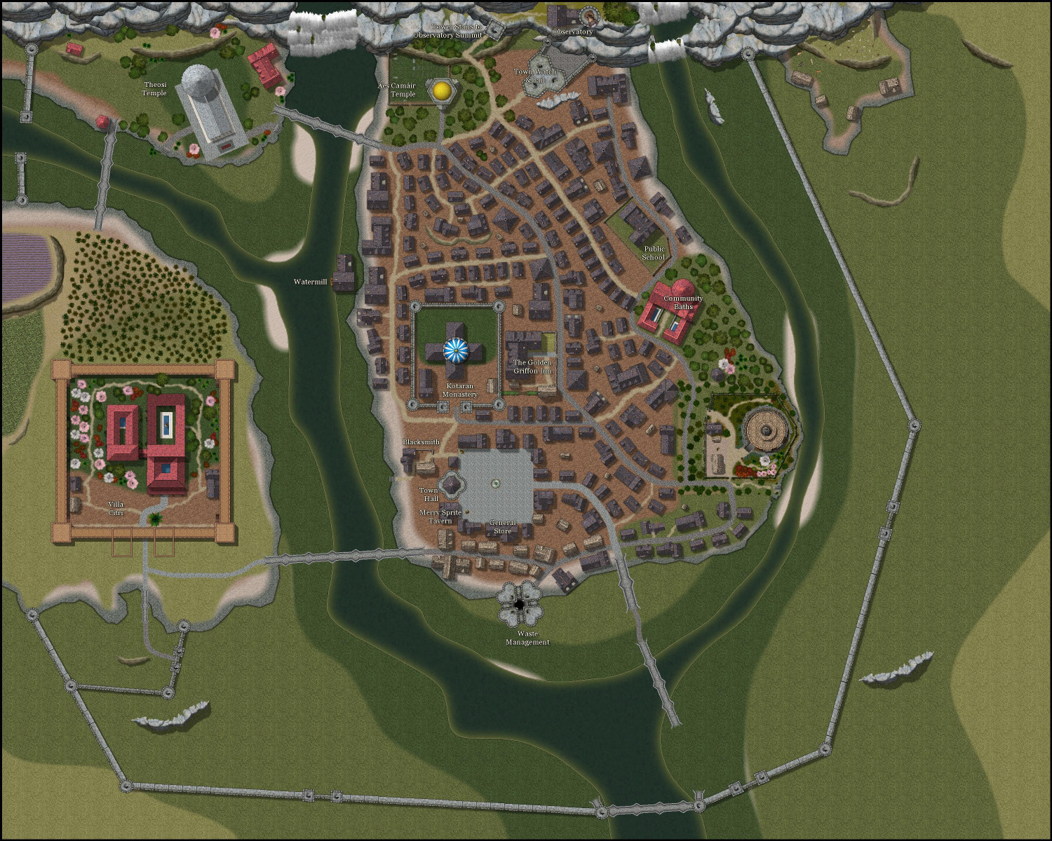
[WIP] Tyr Alomere Township
Properly labeled now.
Have to write up the full description, then do the same with all of the Wizard's Tower files, to get it ready to submit for the Atlas. I also want to design the sewers and the Villa Citri, but those can come later.


-
[WIP] Tyr Alomere Township
Coming along. Still need to finish figuring out the various shops and merchants that surround the town square (I have a general store and an apothecary so far), and then do proper labeling.


-
[WIP] Tyr Alomere Township
I have been out of town this week with family distractions, but I also had the week off of work, so I had a little time to dabble in mapping. I have been working on a township around the wizard's tower I mapped (you can find the exterior and interior maps of the tower in separate threads).
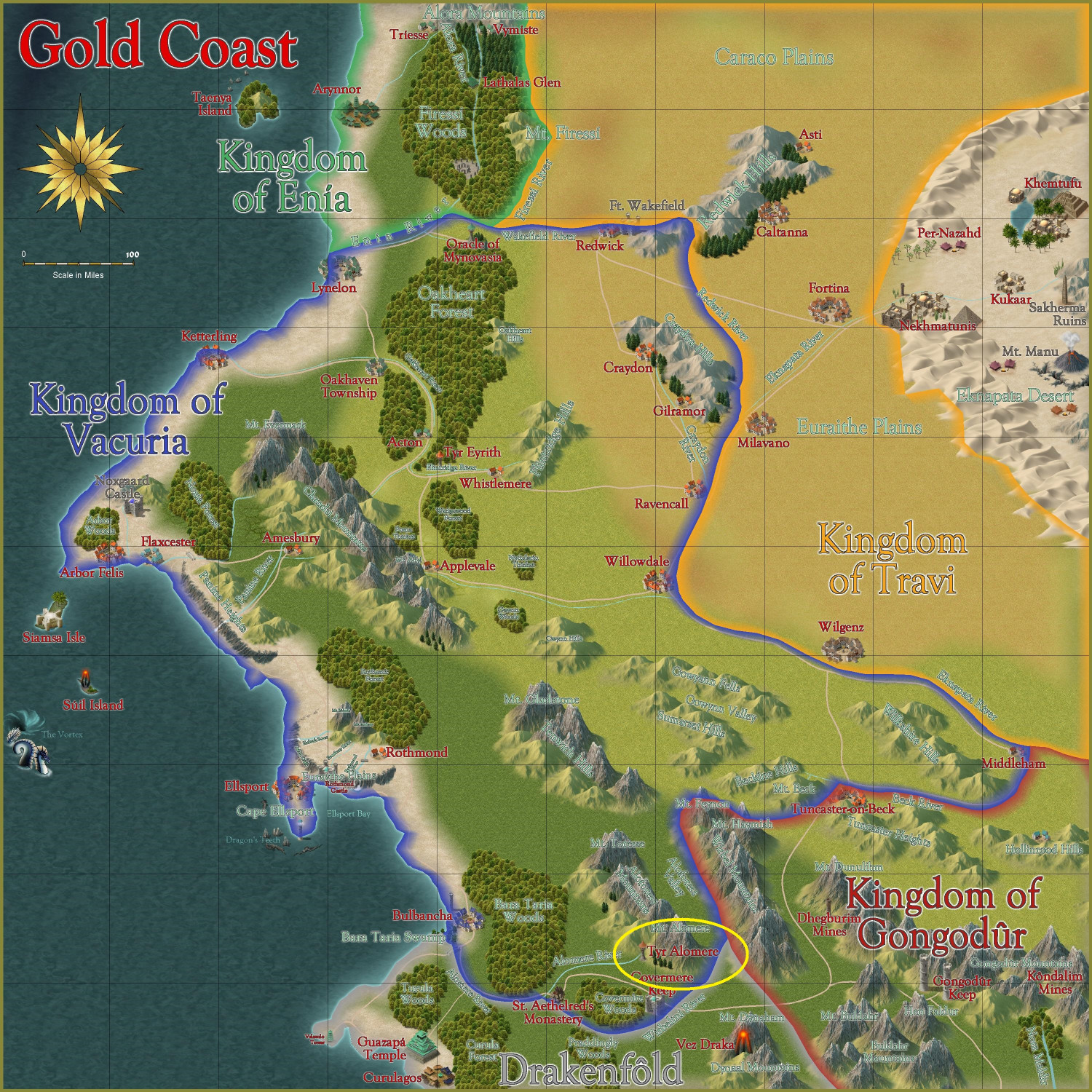
This is intended for the Atlas, in the Gold Coast region on the edges of the Kingdom of Vacturia, nestled in the foothills beneath Mt. Alomere. It is circled in yellow here:
The wizard's tower has been handed down through many generations to one of the wizard's apprentices (often but not always one of the wizard's own children). The town's economy has grown up around the presence of a mighty wizard in residence -- specifically catering to the adventurers and travelers who pass through. Many seek out the wizard for advice on an upcoming quest, or to decipher a prophesy. Some seek to have curses removed, magic items identified, or to stock up on potions and scrolls. The town, too, caters to the adventurers by providing services used by many adventurers. The blacksmith in particular has a busy trade not only in mending armor but also reselling used armor and arms bought from adventurers.
Since the town is in the foothills, I wanted to do some elevation changes. The wizard's tower was built on a Creepy Crypts base, so I continued with that, but also added cliffs and outcrops from Forest Trails and Darklands City.
I have been wanting to do a Roman-style villa for a while, so I decided to create a place for it here. I have added the RGB Matrix effect to the sheets the villa is on to make the Darklands City roof tiles redder.
I still have more to do, particularly thatched houses and farms closer to the walls. I wrote in labels but will replace them with larger numbers, with a legend off to the side.
Anyway, here's the township so far.


-
Live Mapping: Black and White Fantasy
I won’t be able to make it to the Live this week — visiting family and going with my Dad or his speech therapy class. I will watch the recording later today. Have a good chat, everyone!

