Royal Scribe
Royal Scribe
About
- Username
- Royal Scribe
- Joined
- Visits
- 9,533
- Last Active
- Roles
- Member
- Points
- 3,353
- Birthday
- February 5, 1968
- Location
- San Francisco, California
- Website
- https://legacy.drivethrurpg.com/browse/pub/31814/Royal-Scribe-Imaginarium
- Real Name
- Kevin
- Rank
- Mapmaker
- Badges
- 16
Reactions
-
[WIP] - Doriant - Gold Coast - Eknapata Desert - Sakherma Ruins
Below
No toggles for this level.
Description
Sakherma Ruins
Below
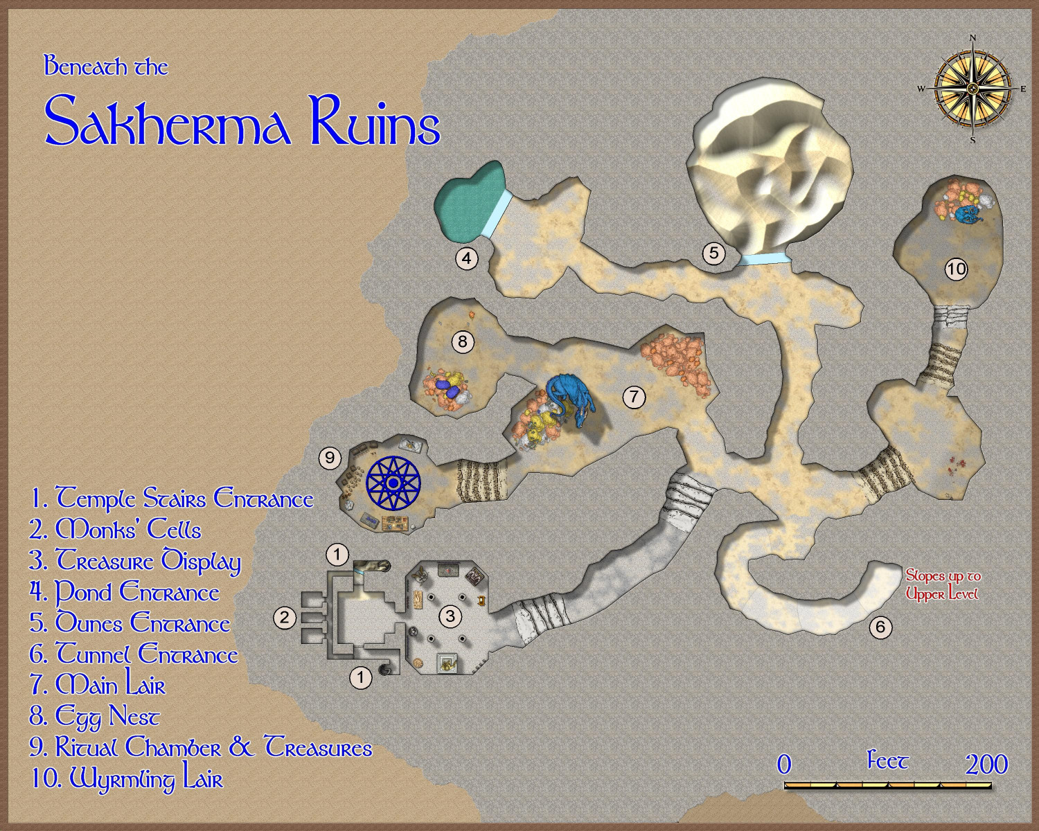
1. Temple Stairs Entrance: Here, the stairs from the temple ruins above descend to human-created chambers. The northern staircase is blocked by sand, but a glass wall keeps the sand from filling the chamber below. The southern staircase is relatively unobstructed.
2. Monks’ Cells: These three chambers appear to once have been home to the monks who maintained the original temple. Game Masters: At the Game Master’s discretion, one or more of these rooms may be occupied by the dragon’s humanoid allies – kobolds, dragonborn, or perhaps sorcerers with a draconic bloodline.
3. Treasure Display: This room is practically cluttered with statues and tapestries. Game Masters: Here the dragon has created a veritable museum showing off its favorite treasures, including a display of magical armaments.
4. Pond Entrance: At the base of the pond, a mighty glass wall keeps the pond’s water from flooding into the tunnels. Game Masters: The dragon can magically pass through the glass without harming it to bathe in the pond, or for another escape route to the outside surface.
5. Dunes Entrance: A great glass wall keeps the sand dunes from pouring into the caverns. Game Masters: The dragon can pass through the glass without harming it in order to reach the surface of the desert, or to devoir travelers camping there.
6. Tunnel Entrance: This tunnel connects the upper and lower caverns.
7. Main Lair: It is readily apparent, if visitors haven’t already figured it out, that this is a dragon’s lair. Piles of coins, particularly copper ones, form its bed.
8. Egg Nest: A blue dragon’s egg lies on top of a pile of coins infused with the dragon’s magic to keep the egg warm when the dragon is away.
9. Ritual Chamber & Treasures: Here the dragon keeps most of its magical treasures. The dragon may also shift into human form to conduct arcane rituals from time to time.
10. Wyrmling Lair: The bedroom for the dragon’s “teenage” child.
-
[WIP] - Doriant - Gold Coast - Eknapata Desert - Sakherma Ruins
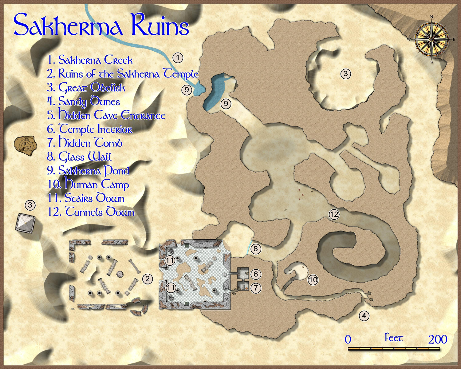
This is the top level map.
Toggles: "Roof" layer to show or hide the mountain covering the interior part of the map.
Description
Sakherma Ruins
At the base of the mountains that is the source of the mighty Eknapa River, an ancient people made their home alongside a creek that fed into the river. What they called themselves is no longer known, but their ruined temple has become known to modern people as the Sakherma Ruins.
These ruins are said to be haunted, and often fatal to those foolish to camp near it. Many groups of travelers have vanished utterly overnight, leaving puddles of blood, occasionally, but no bones nor gear nor even a single copper coin.
Game Masters: Unbeknownst to travelers, a great blue dragon has created a lair beneath the ruins.
1. Sakherma Creek: The water from the creek that ultimately feeds into the Eknapata River is clear, cold, and refreshing.
2. Ruins of the Sakherma Temple: The ruined temple includes an outer courtyard where encroaching sand dunes have toppled many of the temple’s pillars. It also includes an interior temple half submerged in the mountainside. The walls of the interior temple are also crumbling and if it ever had a constructed roof, it’s long gone. A once-hidden secret door behind a pedestal where a statue once stood now plainly reveals the passageway behind it. A second passageway just south of the hidden door has opened in the crumbling walls, as has a much larger one in the northeast corner.
3. Great Obelisk: The obelisk rises forty feet above the desert sands, perhaps the only part of the temple that seems untouched from the day it was created.
4. Sandy Dunes: A crescent-shaped hollow in the mountain on its northeastern side provides a comfortable camping area sheltered from the wind. Game Masters: This is the blue dragon’s main entrance; it is capable of burrowing through from the caverns below to devoir travelers as they sleep, or back down through the sands when it returns home.
5. Hidden Cave Entrance: In the southeastern edge of the mountain, a small cave leads to a tunnel into the mountain.
6. Temple Interior: A great statue is all that remains of a once-ornate hidden shrine.
7. Hidden Tomb: The lid has been removed from the sarcophagus by scavenging thieves, but the shrouded body within remains untouched and seemingly well preserved. Game Masters: If the body or its sarcophagus is touched, the body will rise as a mummy to attack the intruders. The following turn, six animated skeletons will claw their way out of the sand to attack.
8. Glass Wall: A glass wall blocks access from the cavern to the tunnels beyond. Game Masters: The wall was crafted by the dragon using its electrical energy, and because it created the glass, it can magically pass through it without damaging it.
9. Sakherma Pond: The pond that feeds into the Sakherma Creek extends beneath the mountain, creating a pool of fresh water accessible within the caverns.
10. Human Camp: The remains of a human encampment are found in a chamber too small for a large creature to enter. The bodily remains suggest that the occupant was old when he died and did not die violently. Game Masters: It’s unclear if the resident here was hiding from the dragon or friends with it. At any rate, it’s clear the occupant wasn’t eaten by the dragon.
11. Stairs Down: The stairs on the northern side are clogged with sand and are unpassable. The southern staircase is open.
12. Tunnels Down: A great, wide tunnel winds down from the upper caverns to the lower caverns.
-
[WIP] - Doriant - Gold Coast - Eknapata Desert - Sakherma Ruins
Hi Monsen,
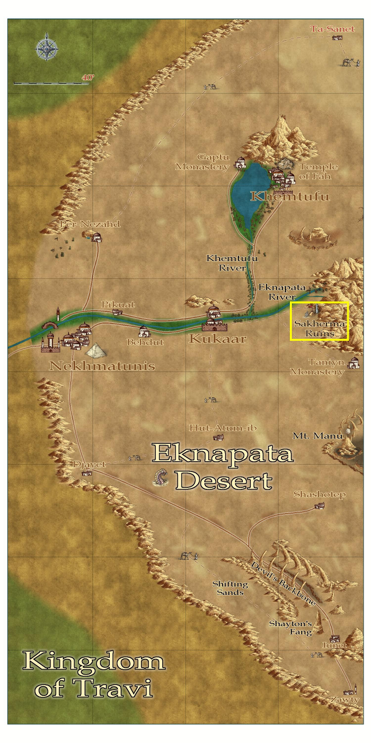
At your convenience, I have a pair of maps to submit. This is for the Sakherma Ruins, which is located in Doriant - Gold Coast - Eknapata Desert in the area boxed here:
I will post the FCW files as follow-ups in this thread.
Also, fellow mappers: I have plans to map the big city of Khemtufu and the Temple of Fah, but feel free to dive in anywhere else in the Eknapata Desert if you wish.
-
Seeking: Feather, scale fills
Aww, thank you, @Wyvern!
-
Seeking: Feather, scale fills
Thank you, Sue. No, please don't drop anything for this! Right now, I'm just experimenting without any time deadlines. And it's not commercial, so that tip is helpful.
I forgot you can't align a Texture Overblend. Let me see if I can experiment with some symbols, or with seamless fills available for noncommercial use.
Thank you!


