Royal Scribe
Royal Scribe
About
- Username
- Royal Scribe
- Joined
- Visits
- 9,533
- Last Active
- Roles
- Member
- Points
- 3,353
- Birthday
- February 5, 1968
- Location
- San Francisco, California
- Website
- https://legacy.drivethrurpg.com/browse/pub/31814/Royal-Scribe-Imaginarium
- Real Name
- Kevin
- Rank
- Mapmaker
- Badges
- 16
Reactions
-
[Atlas Submission] - Doriant - Gold Coast - Eknapata Desert - Sakherma Ruins
-
[Atlas Submission] - Doriant - Gold Coast - Eknapata Desert - Sakherma Ruins
-
[Atlas Submission] - Doriant - Gold Coast - Eknapata Desert - Sakherma Ruins
-
[Atlas Submission] - Doriant - Gold Coast - Eknapata Desert - Sakherma Ruins
Below
No toggles.
Description
Sakherma Ruins
Below
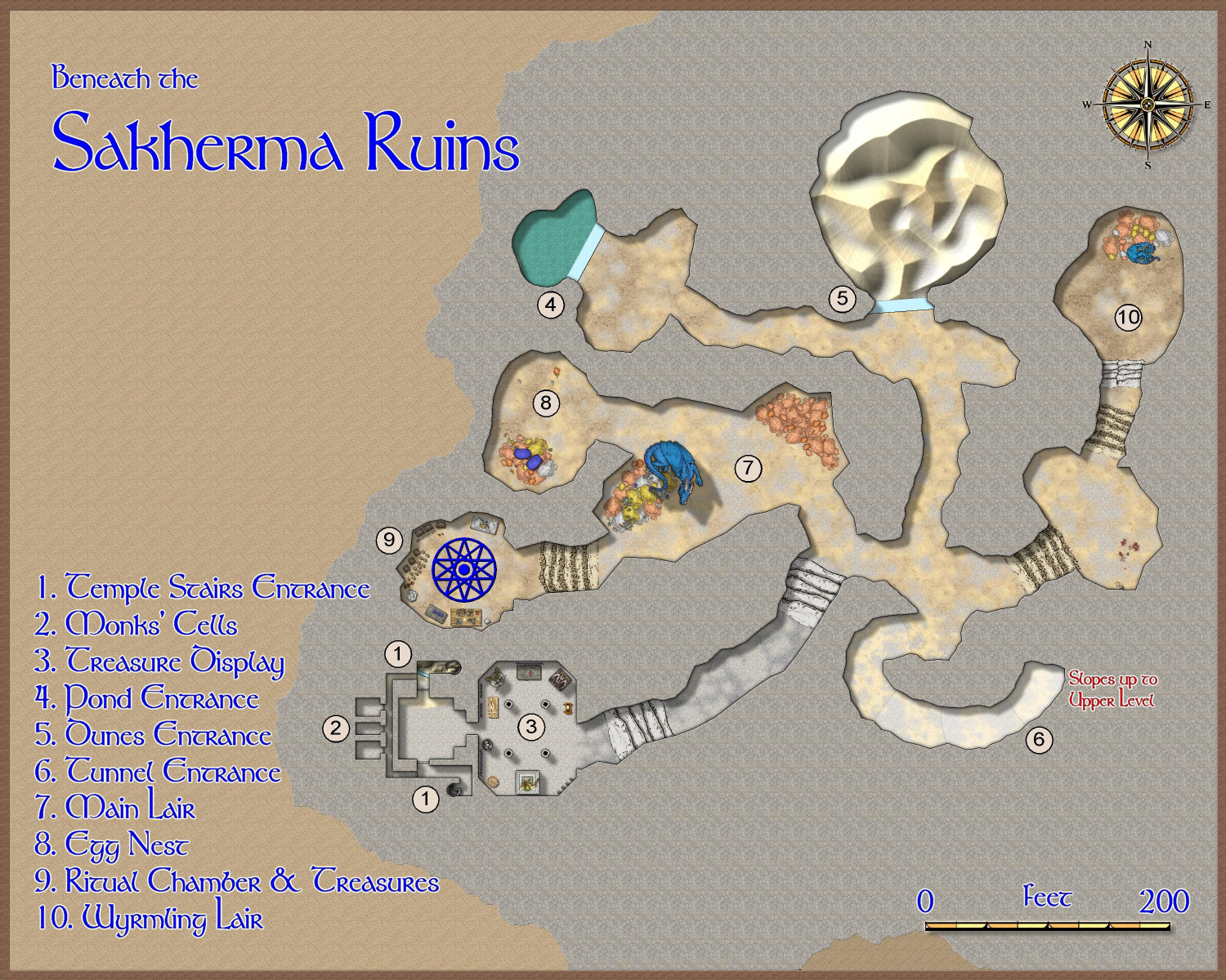
1. Temple Stairs Entrance: Here, the stairs from the temple ruins above descend to human-created chambers. The northern staircase is blocked by sand, but a glass wall keeps the sand from filling the chamber below. The southern staircase is relatively unobstructed.
2. Monks’ Cells: These three chambers appear to once have been home to the monks who maintained the original temple. Game Masters: At the Game Master’s discretion, one or more of these rooms may be occupied by the dragon’s humanoid allies – kobolds, dragonborn, or perhaps sorcerers with a draconic bloodline.
3. Treasure Display: This room is practically cluttered with statues and tapestries. Game Masters: Here the dragon has created a veritable museum showing off its favorite treasures, including a display of magical armaments.
4. Pond Entrance: At the base of the pond, a mighty glass wall keeps the pond’s water from flooding into the tunnels. Game Masters: The dragon can magically pass through the glass without harming it to bathe in the pond, or for another escape route to the outside surface.
5. Dunes Entrance: A great glass wall keeps the sand dunes from pouring into the caverns. Game Masters: The dragon can pass through the glass without harming it in order to reach the surface of the desert, or to devoir travelers camping there.
6. Tunnel Entrance: This tunnel connects the upper and lower caverns.
7. Main Lair: It is readily apparent, if visitors haven’t already figured it out, that this is a dragon’s lair. Piles of coins, particularly copper ones, form its bed.
8. Egg Nest: A blue dragon’s egg lies on top of a pile of coins infused with the dragon’s magic to keep the egg warm when the dragon is away.
9. Ritual Chamber & Treasures: Here the dragon keeps most of its magical treasures. The dragon may also shift into human form to conduct arcane rituals from time to time.
10. Wyrmling Lair: The bedroom for the dragon’s “teenage” child.
-
[WIP] - Doriant - Gold Coast - Eknapata Desert - Sakherma Ruins
No hate from me! I'm getting better with the mechanics of CC3+ but I'm constantly learning new things. And there are lots and lots of people with a better artistic eye than I have who give me great feedback. Even newbies who may not know how to do a particular thing in CC3 can point out things that just don't look right, or might be confusing. Just like with writing, an outside eye is always helpful because the writer or artist may be too close to the work to notice what might be unclear or confusing to the audience.


