Royal Scribe
Royal Scribe
About
- Username
- Royal Scribe
- Joined
- Visits
- 9,534
- Last Active
- Roles
- Member
- Points
- 3,353
- Birthday
- February 5, 1968
- Location
- San Francisco, California
- Website
- https://legacy.drivethrurpg.com/browse/pub/31814/Royal-Scribe-Imaginarium
- Real Name
- Kevin
- Rank
- Mapmaker
- Badges
- 16
Latest Images


Reactions
-
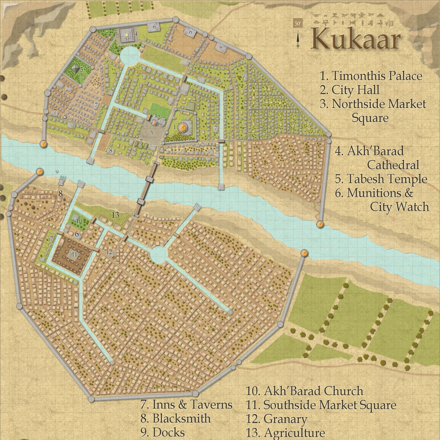
[WIP] Town of Kukaar (Ancient Cities Annual)
Hi everyone,
Thank you for the feedback, it was very helpful. I put the legend back to the original size and location, and it actually looks pretty good. There's room for some lines to wrap if I make it slightly larger, but it seems legible enough as is. Also, I made the roads stand out a little more by changing the transparency effect from 50% opaque to 75% opaque.
Also, are the numbers on the map okay? Should I make them bigger? (I just noticed that some seem to be different sizes, so I will at least have to standardize that.) Are there effects that would make them pop more, like a stronger white glow? Is there anything else unlabeled that should be labeled? I just provided a few sample businesses (inns, blacksmiths, etc.) figuring that a DM could make up something on the fly if players were looking for a specific type of business, but I can add others that folks think are necessary.
Neighborhood maps are a good idea if anyone wants to do a full campaign here (rather than an adventure limited to an inn or a temple, where the rest of the map just provides a general context). I have a whole laundry list of maps I want to do first, but once this is published in the Atlas (after the contest is done), I would welcome anyone to take a neighborhood and expand on it.


-
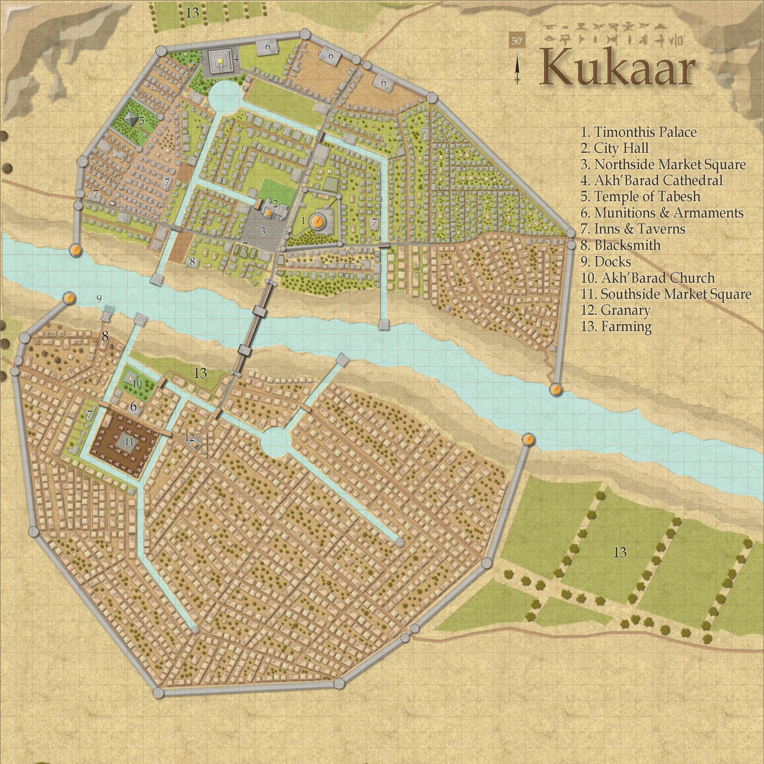
[WIP] Town of Kukaar (Ancient Cities Annual)
Revisiting my ancient town of Kukaar. Now that I'm working on a tiny sliver of the Atlas, I found a place where I would like to place this (once the parent maps are complete). However, my first just-for-fun map was just the wealthier northside district, but to put it in the Atlas, I really needed to map the entire city. I had to expand it southwards, but I didn't like how it looked as a vertical map, so I also expanded east to make it square. That forced me to also add some more residential neighborhoods in the northside, and I decided that a city this size would have a governing noble of some sort, so I also added a palace there.


 and 1 other.
 -
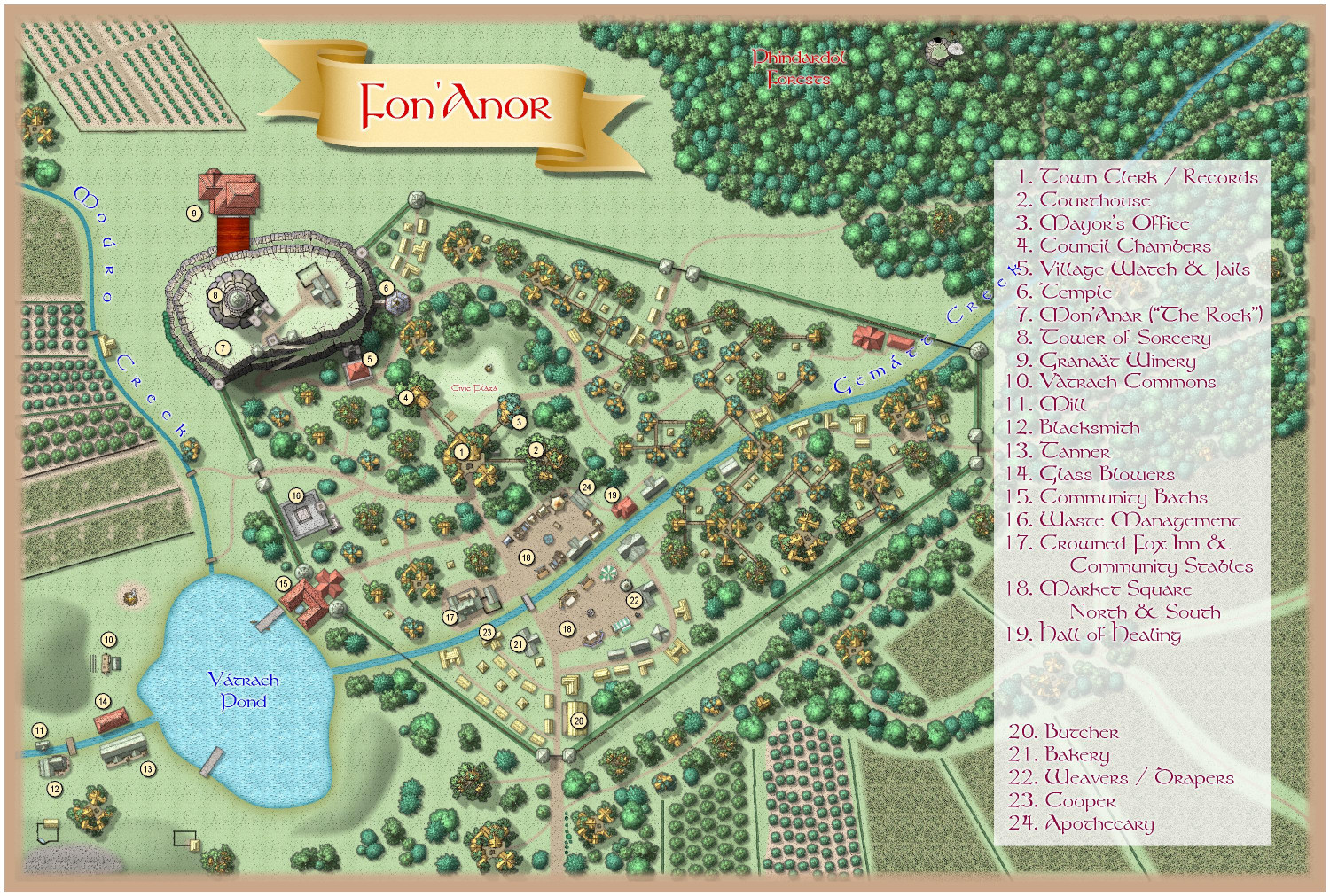
Community Atlas 1000th map Competition - with Prizes [August/September]
I think my contribution to the contest is ready to submit. (If anyone notices any typos or other errors, I will delete and repost.) Here is the FCW, a text file description, and a PDF description. I will also paste the description here below the image.
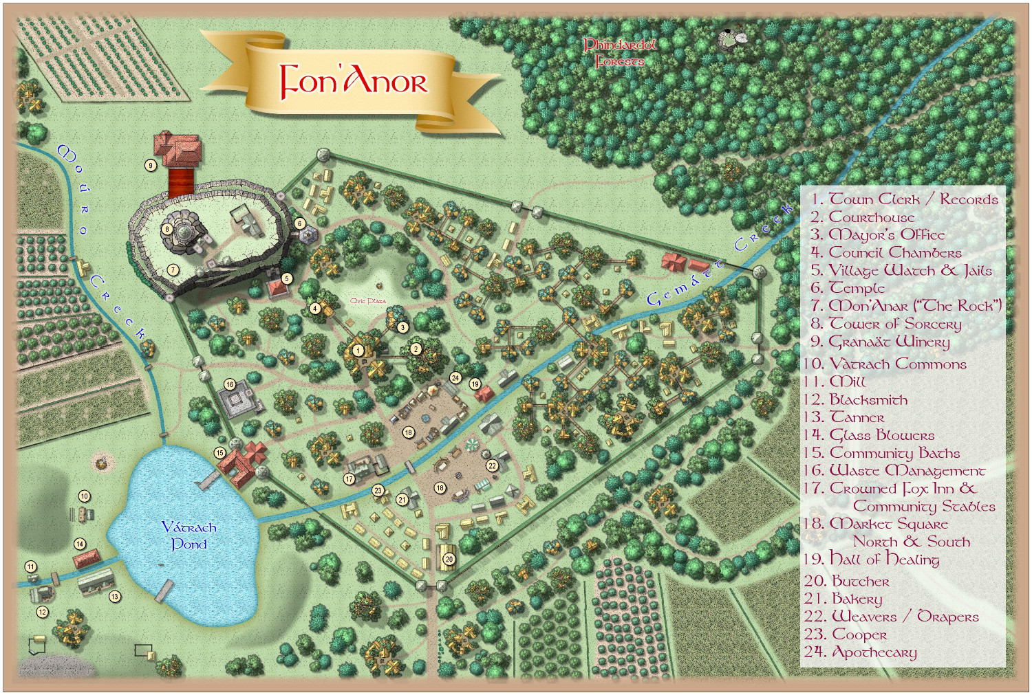
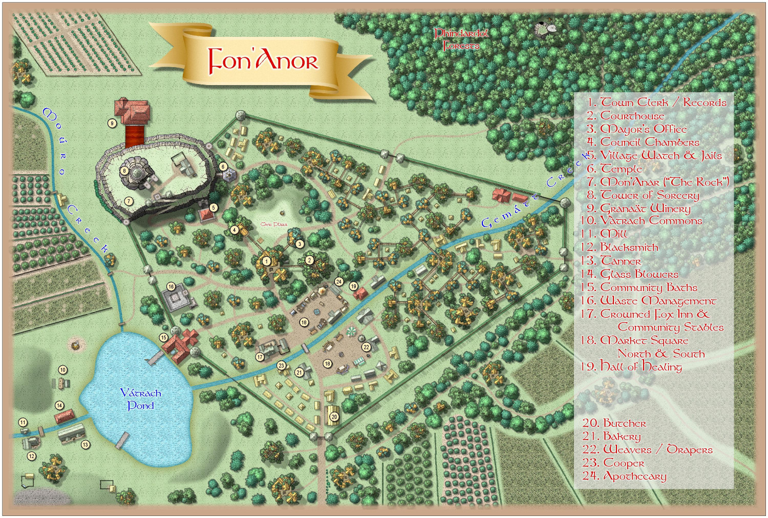
Fon'Anar is a small farming village in the matriarchal kingdom of Verinress'Arl, on the continent of Artemisia. It is a kingdom of Aeifa (surface dwelling drow) ruled by a Matriarch, where succession is by fight to the death among her female offspring. Fon'Anar is located at the edge of the Phindardo Forests on the eastern side of the kingdom.
Fon'Anar is a mostly-self sufficient farming community. It is well known for its fine wines produced at the Granaat Winery. Resellers hire teamsters to travel from other cities and towns in the kingdom to bring back barrels of the wine. Their frequent visits allow Fon'Anar to support an inn, which would otheerwise be unlikely in a village this size. The inn also serves as a tavern and watering hole for the locals. The community is also well-known for their fruit and nut orchards.
The village is governed by a mayor appointed by the local nobility, aided by a five-member village council elected by the local residents.
The village was once a military outpost, and a few military structures remain: a small fortress now used by the village watch as the local jail; a few stone towers; and a great down on top of a 40-foot high rocky outcrop named Mon'Anar, but nicknamed "the rock."
Two creeks run by the village: Gematt Creek, which is about 10-feet wide, and Mouro Creek, which is about five-feet wide. Both creeks feed into Vatrock Pond, which is about 30-feet deep at the deepest part and large enough to support a number of small rowboats. The outflow creek from the pond is also known as Gematt Creek.
A wooden palisade encircles the town. It is enough to keep most predatory animals at bay, but could not withstand a concerted military attack for long.
A great tower abandoned by the military perches on top of Mon'Anar. It was purchased generations ago by a wealthy sorceress who had retired from adventuring. Rumors persist that the sorceress was a scion of a former queen who faked her death rather than fight her sisters for the crown. When she died, she passed the deed to the property to a favored apprentice, and so it has continued to pass from sorceress to apprentice over the generations.
Many villagers live in treehouse homes, connected to one another through elevated bridge walkways. Some villagers (particularly the elderly and the infirm) live in thatch cottages on the ground.
1. TOWN CLERK - Most government is conducted by the clerk, including recording births, marriages, and deaths, and collecting taxes.
2. COURTHOUSE - Traveling judges periodically visit to hold both criminal and civil trials.
3. MAYOR'S OFFICE - The mayor is appointed by the nobility to govern the town in partnership with an elected council. Her offices are located here, as well as living quarters for those who do not have a nicer home in the village.
4. COUNCIL CHAMBERS - The town has an elected five-member council who meet here to manage the village's mundane decisions like managing the maintenance and repair of the palisades.
5. VILLAGE WATCH & JAIL - When the military abandoned their outpost at Fon'Anar, the town watch took over the small fortress, turning it into their headquarters as well as the village jail. Some prison cells have been carved out of the Rock, and the town's treasury is stored there as well.
6. TEMPLE - The temple has a marble hallway that pushes into the cliffs of Mon'Anar. Beneath the Rock, caverns have been carved out for storing church documents and religious artifacts of dubious authenticity. It is rumored that there may be sealed tunnels here that can access vast subterranean cities.
7. MON'ANAR ("The Rock") - Nicknamed "the Rock," Mon'Anar is a natural geological rocky outcrop rising about 40 feet above the village. The Tower of Sorcery is built above it, and three structures cut into the side of the cliffs: the Temple, the Village Watch's fortress, and Granaat Winery.
8. TOWER OF SORCERY - Above the rock, a tower purchased generations ago by a wealthy sorceress looms. The entire top of the Rock is her property, though aside from the tower it mostly holds a gatehouse to guard the entrance and a barn for visitors' horses.
9. GRANAAT WINERY - The wines produced here are legendary, and are sold in many larger towns and cities throughout the realm. The winery has a great barrel-roofed chamber filled with large oak tanks. The wine is later transferred to oak barrels, where it continues to ferment in cool caverns carved into the cliffside.
10. VATRACH COMMONS - Outside the palisades, on the far side of Vatrach Pond, the villagers have constructed an entertainment area. A great bonfire is lit on many nights when the weather permits, allowing locals to sing and dance around it. To the side, a small stage is set up for traveling troubadors, minstrels, and acting troops to entertain the locals, who watch from stone benches before the stage as well as on the hillside behind. A small building behind the stage houses set decorations, props, and costumes, and serves as a dressing room for performers.
11. MILL - A very small watermill is available to use the power of creekwater to grind grain.
12. BLACKSMITH - The smiths primarily creates and repairs horseshoes. They also make farming tools but are not known for making weapons or armor, though they can repair them.
13. TANNER - Tans hides from primary deer hunted in the woods, making and selling leather clothing and armor.
14. GLASS BLOWERS - The glass blowers spend a lot of their time making bottles for the winery, even though much of the wine is exported in oak barrels.
15. COMMUNITY BATHS - Include toilet and bathing facilities for locals and travelers alike, as well as access to recreational facilities. It is the only structure, other than the palisade towers, that spans both outside and within the village walls, and provides one of the only means of passing into or out of the village without passing through the town gates.
16. WASTE MANAGEMENT - Here, garbage and other waste are fed to captive gelatinous cubes and black puddings in order to maintain sanitation.
17. CROWNED FOX INN & COMMUNITY STABLES - Though it mostly serves as a local watering hole, the inn does have accommodations for teamsters and other travelers. The sign outside the inn is painted with a fox wearing a golden crown sprawling across a great throne.
18. MARKET SQUARE - Local farmers and artisans set up booths to sell their produce and goods. The market spans both sides of Gematt Creek.
19. HALL OF HEALING - Serves as a hospital and clinic for the villagers as well as a hospice for the aged who need assistance.
20. BUTCHER - The shepherds and goatherds primarily do their own slaughtering, as do villagers who hunt, but many sell excess meat to the butcher.
21. BAKERY - Also supplies baked treats for the inn and the winery.
22. WEAVER / DRAPERS - A number of fabric artisans operate out of this shop, making and selling clothing and fabric goods of all sorts.
23. COOPER - Although the coopers make all sorts of barrels, chests, and other containers, their principle client is the Granaat Winery.


-
[WIP] Community Atlas Competition - Artemisia - Verinress Arl - Fon'Anar
Here's a version with a darker red:
And here's a version where I tried lighter text on a darker background. (The white ones at the end are the only ones that really work.) For this one, I moved the text to a different sheet so I could turn off the white glow that just made it look bolded in a way that made it harder to read.

-
[WIP] Community Atlas Competition - Artemisia - Verinress Arl - Fon'Anar
Made some good progress, including labeling some of the primary businesses and points of interest. I also widened it a bit to make room for a legend. The text was a little hard to read so I added a semi-transparent back. Let me know if it's still too hard to read, and what you'd recommend to help that (make the back less transparent? darker or lighter shade?)