


Loopysue
Loopysue
About
- Username
- Loopysue
- Joined
- Visits
- 9,985
- Last Active
- Roles
- Member, ProFantasy
- Points
- 9,863
- Birthday
- June 29, 1966
- Location
- Dorset, England, UK
- Real Name
- Sue Daniel (aka 'Mouse')
- Rank
- Cartographer
- Badges
- 27
Latest Images


-
Aegean Isles
That's pretty great for a first map :)

-
October challenge: City Street submission WIP
Excellent mapping going on here :)
Wouldn't that space be kept clear by law to ensure defenders could access the wall easily? I think if I was the Lady of a medieval city I would make sure that no one cluttered that space, and that no trees obliterated the view of the wall itself. I suppose that in very crowded and badly run cities you might end up with stuff right up to the wall, but it would seem to me to be a bad mistake.
Maybe there are features there that just wouldn't show up on the main map. A killing field between the outer wall and a much lower broad raised platform of some kind, like a wide segmented ditch just inside the wall where anyone who managed to make it over the wall would end up becoming trapped with no way out and all the king's men stood higher than them all around?


-
October challenge: City Street submission WIP
Throughout then, I guess :)
Can I join their church?
![[Deleted User]](https://secure.gravatar.com/avatar/c75d9a245b74d9c59be0999ea81ca541/?default=https%3A%2F%2Fvanillicon.com%2F92add7f8c954488718110edc4896ad39_200.png&rating=g&size=200)
-
Help Converting Fractal Terrains 3 landmasses into CC3+landmasses
Hi Koshachiy :)
The way FT3 and CC3 interact can be a little perplexing at first. FT3 exports in a range of formats, as you have already seen, but none of these formats correspond with an actual mapping style.
I don't know which style you want to do your CC3 map in, but lets assume you wanted to draw a Mike Schley overland map using your exported coastline. This is how you would do it
- Open your coastline export and then open a second instance of CC3 by right clicking the CC3 icon and picking CC3+, so you have two maps open at the same time in two CC3 windows.
- In the new instance create a new overland map in the Mike Schley style.
- Go back to the coastline map and use Copy from the Edit menu (or CTRL+C). Watch what the command line is doing. Pick the coastline and Do It. You will need to give the app a copy origin. For that you can either click where you like or type coordinates in on your keyboard.
- When the copy is done (the pink highlight vanishes) go to the window with your new Mike Schley map and use Edit-Paste (or CTRL+V). Then you will need to position the cursor so the coastline is in the right place. Holding down the CTRL key while you move your mouse will allow you to scale the copy before you paste it.
- Click once only to paste the map, and then hit ESC to get rid of it off your cursor, or you might end up pasting it several times over - each time you click.
Then you will need to use the Change Properties button on the left toolbar to change the properties of the coastline to have a land fill and be on the correct sheet (if it is not already).
I hope that helps :)
EDIT: I should probably warn you that if you have exported the coastline at a very high resolution the paste operation may take a few minutes. CC3 will attempt to refresh the view every time you move the cursor, even if that is only a tiny fraction. Even when the cursor is motionless the outline will continue to refresh in a wave like pattern. Don't be concerned by this. It is perfectly normal and to be expected when there may be several tens of thousands of nodes in active memory on the end of your cursor. CC3 just keeps going, though, and will only freeze up or crash if you get seriously impatient with it.

-
Using fractalization, land mass, or ocean, vanishes. It isn't in the map afterwards
Hi Jim. I was just messing around with the map while Remy and I were talking about it behind scenes and discovered that there were things on the MAP BORDER layer that shouldn't be there. I moved them onto a new temporary layer and the fractalisation worked fine.
I hope that cures it for you. If it doesn't just shout.

-
October Challenge WIP
It looks terrific :)
Don't forget to add it to the main sticky thread.

-
Tilkar map
Maybe people will ask questions and make suggestions tomorrow during the live stream. It will be easier for them to see what you've already done, then.
I am also quite sure that Ralf would have said so if he felt that the set was in any way unfinished ;)

-
Opening multiple instances of CC3+ on a Mac with OS Catalina
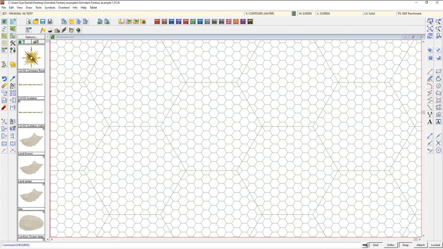
I've just drawn this one using the "select points" option. I drew the first 5ft grid allowing it to generate a snap grid, then used that snap grid to pick the select points position for the 50ft grid.
-
Opening multiple instances of CC3+ on a Mac with OS Catalina
If you mean like this
That's just a matter of which snap point you pick to start your grid. If you get the wrong one just hit ESC and try again.
Don't forget that you don't have to have your grids perfectly matched with the edges of the map, because the overlap will be hidden by the screen and frame of the map. It is highly unlikely that your map will be exactly and perfectly a whole number of hexes in either direction, but that is perfectly normal. If you are really intent on trying to align the whole grid system on the map, try for just one of the corners (which equates to 2 adjacent sides). More than that is a bit extreme.
-
Opening multiple instances of CC3+ on a Mac with OS Catalina
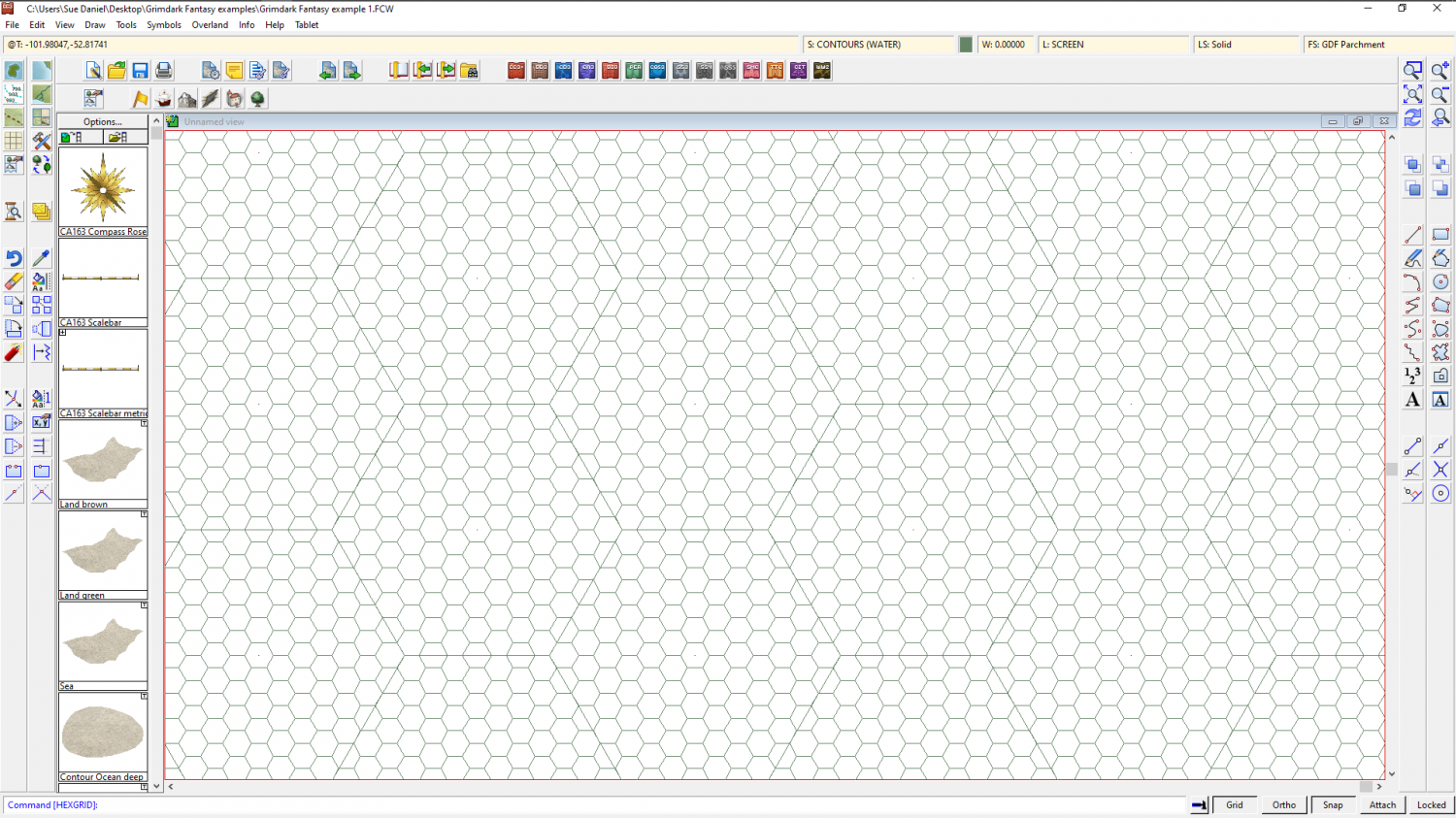
This method will give you a great visual grid, but doesn't really sort out a snapping grid. I am assuming that your client isn't going to be using CC3 him or herself, so the CC3 snapping grid is only relevant if you need it to align things in the map with the grid...
- Use the Select Points option both times, and the set snap grid option only for the first grid of smaller hexes. That's the snap grid you will use to align the grids with each other.
- If you draw the 5ft grid first, drawing it to one side of the map a little larger than the map itself, when you draw your 50ft grid over it pick one of the intersections of 3 small hexes as the starting point for the 50ft grid.
- Once you have both grids drawn, group them so they can be moved as one object, switch on Attach, and use the move tool to pick them up by the intersection you want to place at the origin of your map. Then type the coordinates 0,0 and hit enter. This will align the intersection at the origin of your map, which (unless you have moved the frame and screen around by hand) should be the bottom left corner.
- The User snap grid is useless to you now, even though you created it with the small hexes, so right click the Grid button and pick it and delete it.
