


Loopysue
Loopysue
About
- Username
- Loopysue
- Joined
- Visits
- 9,983
- Last Active
- Roles
- Member, ProFantasy
- Points
- 9,863
- Birthday
- June 29, 1966
- Location
- Dorset, England, UK
- Real Name
- Sue Daniel (aka 'Mouse')
- Rank
- Cartographer
- Badges
- 27
Latest Images


-
Watabou Medieval Fantasy City Generator updates FYI
Thanks for letting us know, Quenten. I could have done with this about 4 months ago when I was scratching my head over the exact arrangement of houses in the first handful of Spectrum structure symbols. It's not as easy as you think, so I never went to Watabou because of the triangular houses. They would have been no good for what I wanted.
Now, though, this might take days off the workload.
I can download the 3D file and break up the model to rearrange the buildings like setting up for a college still life drawing. You know the sort of thing - 3 hours to draw a carrot, an onion and a chopping board in amazing photographic detail :) (That's what I had to do for my O'level 39 years ago).
![[Deleted User]](https://secure.gravatar.com/avatar/c75d9a245b74d9c59be0999ea81ca541/?default=https%3A%2F%2Fvanillicon.com%2F92add7f8c954488718110edc4896ad39_200.png&rating=g&size=200)

-
Mike Patterson (Maidhc O Casain)
I wouldn't say that was mundane!
You're like me, and lots of other people as well. We got on with life and made stuff along the way in those odd moments of time between all the busy stuff :)
Thanks for sharing!

-
Project Spectrum - Part 2
Thank you, Farsight :)
Those are called varicolour symbols, and are generated after the original colour image by the addition of a second png file that denotes the areas that will change colour. If you look through the folders of artwork for the Mike Schley style you will see them. They look like ghost images of the original. These tend to be later additions to a symbol set. The fact that part 1 had varicolour structures was down to Ralf Schemmann generating the necessary files once I handed the set over to him.
I really can't say if there will be time to do more for part 2. That depends a lot on what Ralf has got on his plate in the last fortnight of October ;)

-
CA155 and FT3 Percent Sea?
This is to do with extreme altitudes and data that isn't a number - Outliers and NANs.
The instructions on how to ensure your world is free of them are the last 2 paragraphs on page 10 and all of page 11 of the Supplemental Notes.
With hindsight I maybe should have put this in the main Mapping Guide, but at the time I didn't think these things affected unedited synthetic worlds. Isn't hindsight a wonderful thing!

-
WIP: Tilkar map
Oh these are very interesting. Please do keep posting :)
Trees are always tricky things to get right. Their size seems to be a key issue, but whether you like them large or small the size of a tree will ultimately depend on what size you mean to use your map. There is no point in having trees that are too small to be easily identified as trees.


-
HomeBrew World of Andaar by F.W.Whited Drawn By D.A.McDowell CC3+
It is basically a good map, though you are missing a scale bar.
The one thing that may need a bit of tweaking is the placement of trees. What is the map telling us? I get the message that this is either dense jungle and covered all over by trees that are represented by the spaced out single trees, or that there are remarkably even copses of trees, each symbolised by a single tree. Since I don't know the scale I can't be sure which of these may be true.
If your area is only partly wooded (for example a forest that has been eaten into by agriculture, or which has large clearings of grassland) it may be communicated more effectively by creating clumps of trees as wooded areas.
Take a look at other maps and the way that other people have shown forest and jungle. If you think a different method might portray your area better, it may be time to reconsider the tree placement.
-
Community Atlas - Blackrock WIP
Ok. I'm not sure I will have time to look at the FCW, where I'm up to my eyeballs in Japanese structures in Sketchup right now, but I'm pretty sure that even with just a few more weeks experience you will probably find it yourself anyway.
As for the scale of the fill - maybe. The thing about fills is that if you scale them up too much they pixelate, so it very much depends on how large you want to print your map. There are two ways of disguising the redundancy (which is what we call it when a seamless tile starts to generate that kind of noticeable pattern). You can either put a lot more in the map so that not enough of the background shows through for the pattern to be visible (you will have some idea of how that works by looking at the area of the settlement). The other way is only necessary if you don't intend to put anything at all in the rest of the grassy area, and involves creating irregular patches of a very similar coloured texture on another sheet above the grass that are themselves not large enough to have the problem, but which cover one in three or four of the more noticeable parts of the pattern where they appear in a line or column without interruption.

-
Community Atlas - Blackrock WIP
It's looking pretty cool, Jim :)
I think you might have an unexpected glow effect, or something similar set on the sheet with the second level of grass on it. That would be what is causing that darker line between the different levels of grass. If you haven't got anything like that I would be interested in seeing what you do have on that sheet.
-
Fix Grid and Snap?
Its when you get to cackling hysterically at the mess you're in trying to spin a Blender terrain the same way you would a Gaea terrain that you know it's time to take a break.

-
Community Atlas - Blackrock WIP
That's quite a lot of work for the time - especially if you are trying to do stuff you haven't done before :)
There is an awful lot of space involved in this map that in the real world would be totally covered with detail almost as dense as the detail of the city itself. There would be a network of smaller roads and tracks with hamlets and farms along them, and the rest of the land would be covered in fields, woods and moorland. A city needs a network of satellite settlements to provide it with food and other produce. Presumably there will be a lot more than just a few bags of grain and the odd cabbage being sold in the market place. The fields you have done are good, but they wouldn't provide everything the citizens of Blackrock need for a healthy and varied diet - or enough of it by far. I think they would be killing each other for flour to make bread only a month after the grain harvest was done.
There are lots of other land uses besides woodland and fields. Have you thought about mills, cemeteries, or landmarks like ruins?
I sometimes add a sheet called SKETCH to the top of the map that can be deleted when the map is done, and I draw on it in white with the freehand drawing tool the approximate position of satellite settlements, roads and field systems etc. This makes it easier to fill in the area with the required amount of detail without having to entirely re-imagine everything every time I've finished a single field or copse before I do the next field or copse. I draw the manmade stuff first, and then fill in the gaps with fields and woods as appropriate.
Title's, scale bars and compasses also help, and it is sometimes easier to pick a spot for these before it gets too crowded with detail so you don't end up covering a bit you are proud of with the title, or try to squish the title into the corner to avoid it.
The Symbols in Area tools use the default symbol scale, which is set in the Drawing Presets dialog here:
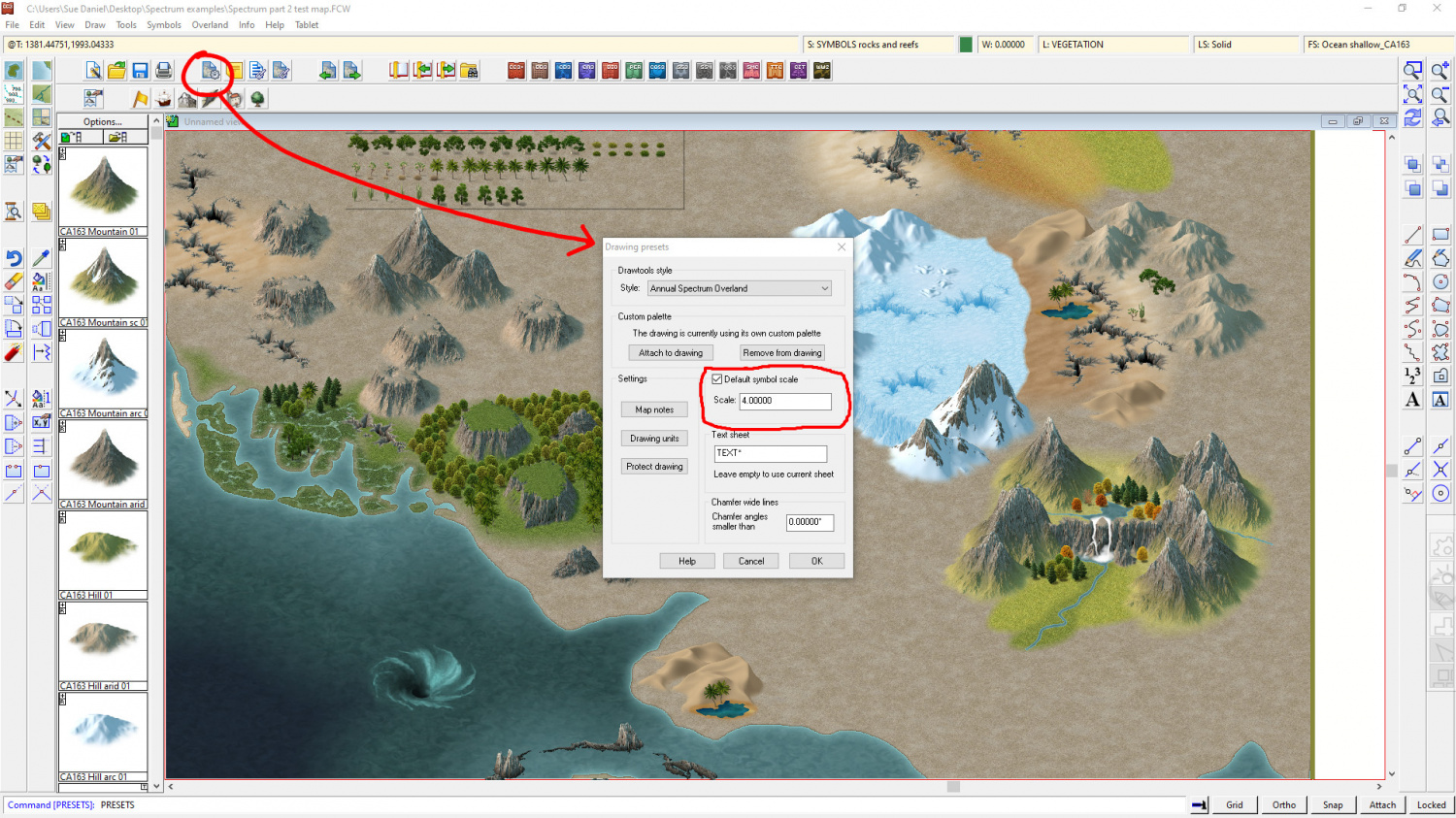
I would make a note of what the scale is before you change it, so that you can go back to the default when you are done.
Mapping can be slow when you are learning. And that is exactly the point. You might not have got a lot done on the map, but you did a lot of learning that will help you be much faster next time you are doing a city. That is nothing to be scoffed at - especially if you are aiming to do commissions one day, where time is of the essence and could make or break your bid if it is only one among many.
If you upload your FCW I think you might find that several people will look at it, and you will get a nice cluster of suggestions to pick little gems from and learn even more.
