


Loopysue
Loopysue
About
- Username
- Loopysue
- Joined
- Visits
- 9,980
- Last Active
- Roles
- Member, ProFantasy
- Points
- 9,863
- Birthday
- June 29, 1966
- Location
- Dorset, England, UK
- Real Name
- Sue Daniel (aka 'Mouse')
- Rank
- Cartographer
- Badges
- 27
Latest Images


-
Horizontal lines between walls when tracing
These are caused by the nodes being too close together in a heavily fractalised polygon. Notice how they occur on the fractalised parts of the object rather than the simple straight line sections.
Undo or delete the new wall tracing and use the keyboard command SIMPLIFY, set a distance of about 0.25 (if that is a 5ft snap grid I can see), on the floor polygon. What this will do is remove any node that is only 0.25 feet or less in distance away from it's neighbour. Then either trace the wall shape again, or copy that polygon onto the WALLS sheet and hide the FLOORS sheet to change the properties on the WALLS sheet to create the new wall.


-
Having trouble installing CA 200 Inked Ruins
Yes, this annual issue was not code-signed in the rush to leave for Gen Con, so windows will be a little fussy at installation. Ralf said he would fix it when he got back. I don't know if he already has, but in the meantime if you are talking about Windows Defender you can override that fuss. It's perfectly safe - just unsigned.
EDIT: I just downloaded it again myself. It looks like Ralf has updated it if you want to download it again.
I use Windows Defender myself. As long as you right click the installer and pick Run as Administrator it should be ok.

-
Settings to export PNG for use as a Symbol
Depending on the type of map you are making...
Dungeon style symbols are usually imported at 100 px per map unit
City symbols are usually imported at 40 px per map unit
Overland symbols are usually imported at 20 px per map unit.
So it really depends on what type of map and how big you want your shield.


-
Live Mapping: New City Style Part 3
Hi everyone! :D
This week in our Live Mapping session, Ralf will be adding a third and final part to the New City Style series, using the new style he created in the first two parts (links below) to actually draw a city map. In the process he will be adjusting and refining the style to complete it.
Come join us on YouTube here, where you can ask questions and join in the chat:
https://www.youtube.com/watch?v=kVhCGEIrYrw
Or you can watch it here on the forum if you prefer.
The first two parts of this series can be found here:
Live Mapping: New City Style (Part 1): https://www.youtube.com/watch?v=wrzhfzKIIbM
Live Mapping: New City Style (Part 2): https://www.youtube.com/watch?v=-498AxHw6EI

-
Live Mapping: E Prybylski 2 and Political Maps
It's in the blog, Quenten.

-
Regular poly vs Irregular (shape)
Yes - I also really like the map as it is. Great sheet effects on the glowing purple worm.

-
Live Mapping - Lava Caves & Virtual Tabletops
Hot stuff, Remy! :D


-
(WIP) Night City
You can easily set up your own House style, and then use it to create your own Street styles.
The process is shown in several of the live mapping sessions. I will be back to edit and add a few links when I've found a good one.
EDIT: Try this one, Julian. https://www.youtube.com/watch?v=7dLtzBiObwY
-
Creating a Template to simulate the Khorvaire Map
Ok, that's good to know :)
For the landmass and ocean I recommend Darklands Overland style from the 2021 annual. Read the mapping guide for that one carefully since the sea goes on top of the land. That will give you a parchment land mass and will allow the different colours blended onto the land to extend right up to the coast despite being broadly blurred to give that soft colouration effect. there are set colours for the drawing tools, but you can clone and modify the drawing tools if you want different colours.
Once the land is put down and all the colours sorted out I think your ideas for the symbols are pretty good as it goes, though you might find it a little tricky matching them on a comparatively dark background like Darklands Overland. If that happens use the Mike Schley inks style and add a Blend Mode sheet effect to the symbols sheets set to Multiply to get rid of the white parts.
As for the structure symbols Remy has already explained those.
That leaves just the escarpment symbols. The closest I can think to that style is possibly the escarpments from the new E Prybylski Watercolor style in this year's annual, but they might not match that well.

-
Creating a Template to simulate the Khorvaire Map
Then when you start adding the colour patches for the terrain you can draw them as far under the sea as you like and they will be masked by the water when you refresh the drawing.
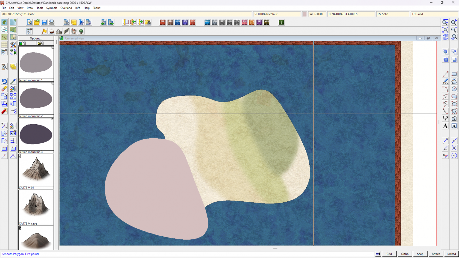
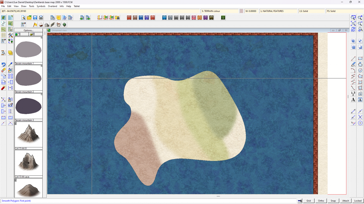
(this is the point at which you might want to make some new drawing tools to add more orangey colours for the desert than the pinkish ones I did)

