


Loopysue
Loopysue
About
- Username
- Loopysue
- Joined
- Visits
- 9,978
- Last Active
- Roles
- Member, ProFantasy
- Points
- 9,861
- Birthday
- June 29, 1966
- Location
- Dorset, England, UK
- Real Name
- Sue Daniel (aka 'Mouse')
- Rank
- Cartographer
- Badges
- 27
Latest Images


-
Live Mapping: 1930s Floorplans
Hi everyone! :D
This week in our Live Mapping session, Ralf will be completing his 1930s Travel Guide series by creating a floorplan in the Baedeker-inspired style.
You can watch it right here on the forum, but you would be most welcome coming along to join in the chat, live on YouTube here: https://www.youtube.com/watch?v=TH69okYSPQw


-
Lake sort of glazes over
You can use the lake polygon as a cut out shape on more than one sheet. I've set it up for you in this version. All I did was add a Color Key sheet effect to the TERRAIN FARMLAND sheet, change the properties of the lake to solid colour 6 (magenta), moved it to the TERRAIN FARMLAND sheet and copied it from there to the LAND sheet.
There's nothing left on the actual LAKES sheet now.
I hope this is what you wanted?

-
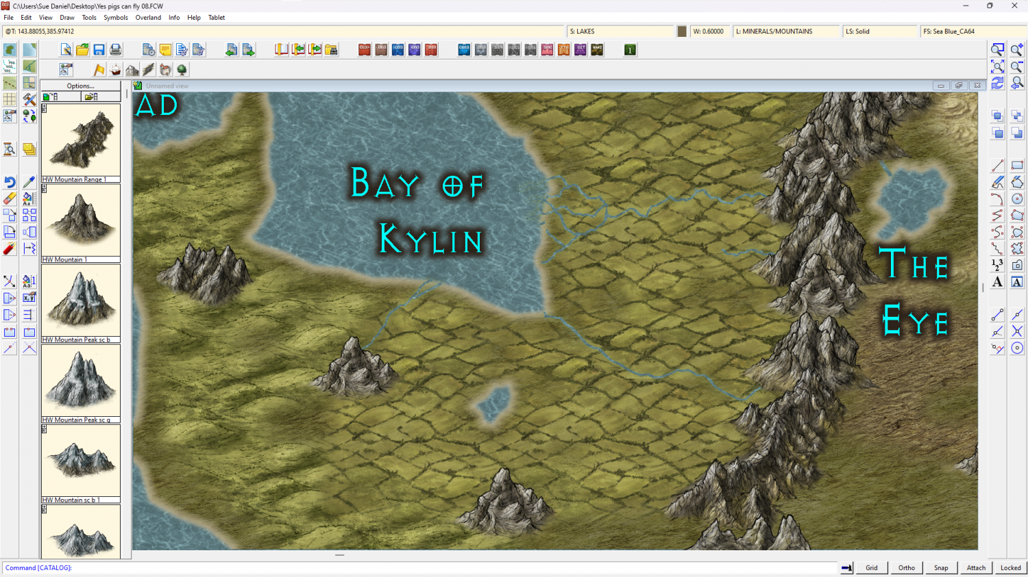
[WIP] Continent Map using CC3+ MS Overland and other resources
If you right click the fractalize button there's an option to convert Straight to Smooth. You can go back and forth with it. You might want to fractalise it just a bit more right now before going smooth as that will give it a more wiggly appearance. Don't go overboard, though. No more than 3 hits with the fractalize tool at it's default setting. Then go smooth and see what you think.
Save a copy first ;)

-
Community Atlas - North West Berenur - Azin Forest
A fantastic set of maps. Thanks very much, Ricko :)

-
A New In-World Map for My 5e Homebrew
Good work :)
Maybe the coastline can be made thicker, or the most pointy hills shrunk down to miniature size and used as waves? You could draw your own vector symbol waves, or if you have the latest annual issue (Ellis Prybylski Watercolour) there are wave symbols in that one.
You could try a pale transparent shape over the sea to make it fractionally darker than the land, but it might look odd where this is a linework style.
The effect around the labels is a little narrow to separate them from the black detail of the map, but it might be ok if the map is much larger than here.

-
How to export very large maps
Incidentally...
Is it crashing after the passes are done and during the processing of the final image from bmp to png? If it is then the sheer size of the resulting png file may actually be the problem. Try for a JPG instead.

-
Forest encounter area - Forest trails + SS2A
You're welcome :)
I've just noticed how low your JPG quality settings are. That probably isn't helping the appearance of the map. The default is much higher than that and will still produce a relatively small file. Try about 85% and see if that helps.

-
[WIP] First Cosmographer Map - Space Elevator Cabin
Yes, thanks.
There may be a less 'aeroplane' way of doing the seating if there is no forward direction. I remember being on a hydrofoil across the channel to France a long time ago when such things were really new. The seating took me a bit by surprise, as it was arranged in little 'cups' with a small table for you to put your refreshments on, so you could sit together as if you were in a cafe. It wasn't very spacious, but it was a whole lot more friendly than rows. It was quite impossible to see anything but sky through the windows anyway, so forward wasn't really all that interesting to look at. But maybe your vessel is more military than that, and I think the military tend to stick with endless rows of things.
-
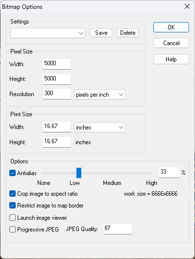
Map Size - ReSize
That's a different thing again.
The size of your map in CC3 doesn't really matter. It's the size you export it as an image.
When you pick Save as... from the File menu the Save as... dialog box has a drop down box where you can pick the kind of file. Pick one of the rectangular section images. JPEG is better for VTT because PNG are a bit large. Once you've picked your Rectangular section JPEG click the Options button. That will bring up this box.
These just happen to be my settings as they are this moment in time. They probably won't be what you need unless there is a huge coincidence. So work out how big you want your exported image (adjusting any of the settings will affect the others accordingly), and ok them. Then export your map. A rectangular section export requires you to click both the opposite corners of the rectangle you want to export.
-
Map Size - ReSize
Hi Gulwolf :)
Resize is different to scale because it works by leaving most things as they are but extending the background, map border, screen and any frame the map might have. This is to increase the space available to draw extra bits onto the edges of the map, while scale just makes the whole map bigger, including all the symbols and fills.
If you were trying to get some more space to continue the map beyond the current edges and your 'sea level' was supposed to be stretched like the background was, reverse the resize operation by doing it again but putting the old size back in, then move your sea level to the BACKGROUND layer using Change Properties. (That's the layer, not the sheet. It can stay on whatever sheet it is on.) The Resize operation should then work as before but this time include the sea level information.

