


Loopysue
Loopysue
About
- Username
- Loopysue
- Joined
- Visits
- 9,993
- Last Active
- Roles
- Member, ProFantasy
- Points
- 9,869
- Birthday
- June 29, 1966
- Location
- Dorset, England, UK
- Real Name
- Sue Daniel (aka 'Mouse')
- Rank
- Cartographer
- Badges
- 27
Latest Images


-
Birdseye Continental - style development thread
I will leave them till last and do them as vector symbols instead of bitmap ones. It will be easier for people to make their own personalised ones that way as well.


-
Birdseye Continental - style development thread
I guess they're ok, for now.
Now I just have to get on with the ridges and so on.
-
What art programs do you use?
I don't think GIMP is that bad, but the way each of us feels about various apps is all very relative on a personal level. I was pretty good with Corel Suite before I came onto the mapping scene, so everything else seemed quite simple to me - including CC.
All except Inkscape!

-
unsure what I've done to the border
You were helpful, Don.
With a bit more practice we can be a team :)
-
Installation of new monthly content - Fractal Parchment Worlds
Don't worry, EdE. The thread is easily short enough for everyone to see that Quenten answered your question, and that all I did was add details to that answer.
I have already let Ralf know the link is broken, so further tech reports shouldn't be necessary at this point. Ralf will update the installer and let us know when it's available for re-download.
-
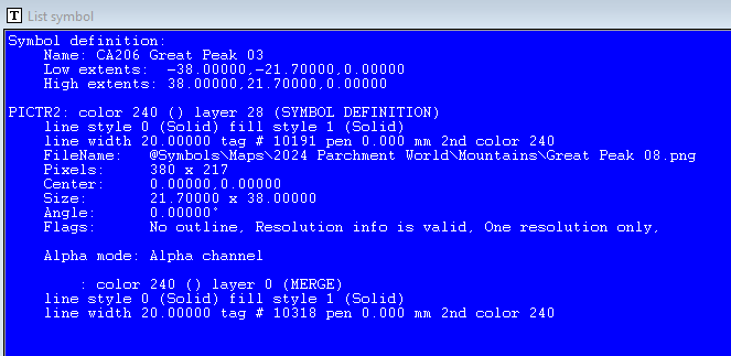
Creating Symbol Catalog issue.
However, the problem has been swishing around my mind for a few minutes...
Have you tried editing the symbol through the Symbol Manager and bringing the text to the front?
Oh wait a minute! Are you using the actual symbol instead of the png the symbol is created from? You might need to import the png, then make the symbol with that non-symbolised png image.

-
Creating Symbol Catalog issue.
If the CSUAC folder and catalogue structure follows the same convention as the Profantasy ones, the folder containing the png should be in the same parent folder as the catalogue, and may even bear the same name.
Alternatively, if you open the Symbol Manager and pick the symbol you want to find the png for, then hit the List button, it should give you the location and filename of the png on the 9th line.
-
Background Tiled?
Thanks.
I think Ralf is looking into it.

-
First Map Feedback
Hi Ryan, and welcome to the forum :)
This is a good start to your project. You've asked for a few pointers, so here are my main ones:
Symbol scale.
I notice you have varied the size of the symbols, particularly the trees and/or structures (the towns/cities/villages etc) to relate to each other in a more realistic world scale - a bit like you might if you were making a dungeon map, or an artistic picture map that is also a kind of concept image of the world. However, this has left you with structures that are pretty hard to identify for what they are. I recommend that you consider making the structures at least twice the size they currently are so that people looking at the map can see the difference between (for instance) a walled city and a city without a wall. Remember that when you are mapping at this kind of scale the structures are symbolic rather than realistic depictions, so a city might well be 100 miles across according to the map scale, but it's centre is in the right place and you can see what it is without squinting at it.
That leads me to the next thing. You really need a scale bar - perhaps somewhere to the bottom left.
Placing a scale bar.
Turn on the snap grid (the button called SNAP in the bottom right corner of the window), and click the Borders/Political button |CC2BO| in the top bar to access the cartouches (scale bars, compasses etc). Pick the scale bar you want and hover over the map. Right click anywhere you like before you place the scale bar, and hit the Set normal button, and then the More button.
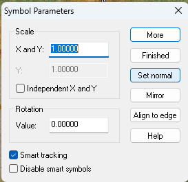
This will give you a scale bar that is the correct length according to it's name, and a way to place it neatly in the map so that labelling it is relatively easy.
Title and compass
In some of that ocean you might want to add a title and a compass?
...
I hope that helps :)
-
WIP: Bleakmoor Harrow - Continent of Estonisch
Suggestions are always welcome, but I think it unlikely for a while at least.


