


Loopysue
Loopysue
About
- Username
- Loopysue
- Joined
- Visits
- 9,992
- Last Active
- Roles
- Member, ProFantasy
- Points
- 9,867
- Birthday
- June 29, 1966
- Location
- Dorset, England, UK
- Real Name
- Sue Daniel (aka 'Mouse')
- Rank
- Cartographer
- Badges
- 27
Latest Images


-
Alternative Complex Room Method
Hi Stephen :)
That's a very handy tutorial. Thanks for sharing.
You can attach pdfs and documents to comments in this forum as long as they aren't too large. It may be better to do that in this case so you don't have to maintain the link to your OneDrive into the future.

-
Mega Continent
Time well spent. It's beautiful :)

-
Using ProFantasy Software for A Commercial Board Game Project
That's the paragraph that gets most contact questions. I asked that one myself a while back before I became an employee. It's the bit of the EULA that really is down to the discretion of the owner of the rights, and which can't be answered by anyone else - not even me.

-
Tracing issues
Well... Please don't laugh, because this actually seems to work for me 9 times out of 10
I'm sure this is anything BUT the official method, but what I do is click the point from where I want to start the tracing, then deliberately head off in the WRONG direction along the coast. This has the tendency to make the trace go off in the opposite direction (as I'm sure you will already have experienced), which if you have deliberately gone in the wrong direction to start with just happens to be the right direction.
Then just back up and carry on as if you haven't just had to trick it into going in the right direction")

-
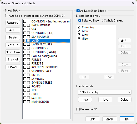
First map - next steps ?
That looks like a great start wintermute :)
Have you tried viewing it with the sheet effects turned on? You can do that by checking the box called 'Activate Sheet Effects' at the top of the Sheets and Effects dialog. (You get this dialog by clicking the Sheets and Effects button|CC2SHEETS|on the left toolbar).
As you have mixed styles together I don't know what sheets and effects you have in this map, so it may not look as you want it to look straight away. However, with a little patience you can add, delete and edit the effects on each sheet to make things right.

-
Live Mapping: Hilltop Fort 1
It's tomorrow, Jim. Thursday, not Wednesday.
-
Annual Issue 155 Supplementary Notes of One Day Worldbuilder
The repaired installer for that annual is being uploaded. In the meantime anyone who just wants to put the pdf problem correct without downloading and reinstalling an entire annual can use the zip file above.

-
Live Mapping: Hilltop Fort 1
A game set in Middle Earth? Why on Earth would you think that? :P

-
Creating Legend/Map Callout Guide/Key
Hi Nic Cho :)
I created that particular legend by hand - typing everything in a succession of text objects aligned on the snap grid. Then I added the fractal shape behind it on a new sheet with either a Transparency or Blend Mode sheet effect on it so the map could still be seen through it.
If you want to have a look at the FCW for this map it's linked to this blog article:
https://rpgmaps.profantasy.com/orde-on-the-rock-map-analysis/#more-5755

-
New world, first draft
Good effort so far :)
Symbol size is always a tricky one. If I was aiming for something about the size of A4 I would do larger symbols than if I was making a map I intended to print as a really huge A0 poster. The consideration I make boils down to "Is this going to be identifiable as a mountain/tree/settlement at the size I intend it to be viewed". Even distance plays a part. If I wanted an A0 poster, but one that was pleasing to look at from a sofa that is 15 feet away from the wall I might make the symbols a bit larger than for an A0 poster to go on the wall behind my desk at a viewing range of only about 2.5-3 feet away.
It's very much a personal choice as well, so there are no hard and fast rules except to pick a symbol scale and try to stick with that scale throughout - unless you are making more of a landscape image or want a gigantic world tree somewhere.

