


Loopysue
Loopysue
About
- Username
- Loopysue
- Joined
- Visits
- 9,987
- Last Active
- Roles
- Member, ProFantasy
- Points
- 9,864
- Birthday
- June 29, 1966
- Location
- Dorset, England, UK
- Real Name
- Sue Daniel (aka 'Mouse')
- Rank
- Cartographer
- Badges
- 27
Latest Images


-
Treehouse ideas
You can attach the current palette to the drawing by clicking the Attach to drawing button in the Drawing presets dialog |CC2PRESETS|
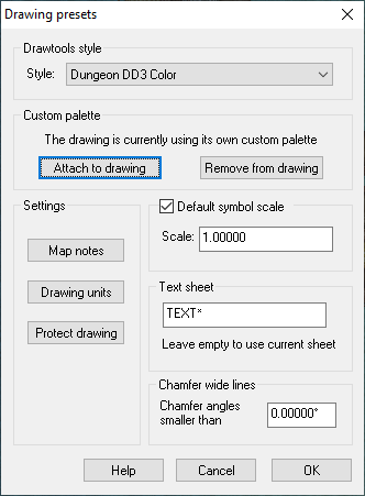
Remember to save the file afterwards.

-
Marine Dungeon - a Cartographer's Annual development thread
Wow! That's quite a wall of text there, Quenten. Unfortunately, I really don't have time to read much (if any) of it.
I think the main use for this annual will be flooded dungeons - places that have been lost to rising sea levels.
![[Deleted User]](https://secure.gravatar.com/avatar/c75d9a245b74d9c59be0999ea81ca541/?default=https%3A%2F%2Fvanillicon.com%2F92add7f8c954488718110edc4896ad39_200.png&rating=g&size=200)

-
Floating City
Ok. That is a pretty big city.
The floating bit will be easier to work on if you have a two tier system in your sheets. Basically, make all the same sheets again and name them the same apart from adding "TOP" or "2" to the end of the name to distinguish the new sheets. Don't duplicate things like frames, borders and ocean backgrounds. Then copy all the sheet effects over to the new sheets, and move all the stuff for the floating island onto the new set of sheets so that the floating island is entirely separated from the rest of the map. You might at that point have to give the floating island it's own 'land' background the exact same shape as the island itself. It will be this shape that will cast the shadow from the island onto the rest of the map below.
Once you have done that I recommend hiding the island sheets altogether and then working on the rest of the city until it is more or less finished, so that you don't subconsciously take roads around the island or place buildings to make space for it. When the island is shown again it should cut things in half - because it's not on the same level.

-
Practical Mapping
That's interesting. I didn't know you could edit a poll!
And I would say it depends. Although I don't play myself I've heard plenty of people come down on either side of that argument for different reasons, ranging from "It's much easier to prepare", to "It gives the game an atmosphere from the start".

-
Too early for a CC4 wishlist thread, or is it timely?
Curiously, there is a command line in quite a few bitmap and mixed bitmap/vector apps. They just don't call it that. Look at this in the same place in Affinity Photo. It serves much the same purpose - giving instructions on how to use the selected tool, and what modifiers you can use. So to change the command line and put it somewhere else would actually be giving CC3 yet another difference from other graphics apps.
The only difference here is in colour and emphasis, and the fact that the command prompt text is not visible.
My personal feelings on the command prompt are that I think the command prompt is useful, but not so critical that it should take up even more space than it already does.

-
Live Mapping: Fantasy Buildings with DD3
In tomorrow's session Ralf will be creating a building floorplan based on the Fantasy Tavern from the Annual 2007.
Book your reminders now by visiting the YouTube link, and come along to join in if you can.

-
Help with lighting
If you haven't already done this, use the EXPORTSETMPPP command to increase the maximum pixels per pass from 4 million to 40 million. The lights are being chopped off because each rendering pass only takes account of the lights within the extent of the pass. Increasing the extent of each pass is usually sufficient to cure this problem.

-
Hi, great to be here from Skillet!
Pst! It's ok Skillet - Remy is Norwegian ;)

-
Change Landmass Borders to different styles?
If you hide or delete the COASTLINE sheet that will get rid of the blue line, which is a separate entity to the land drawn on the LAND sheet.
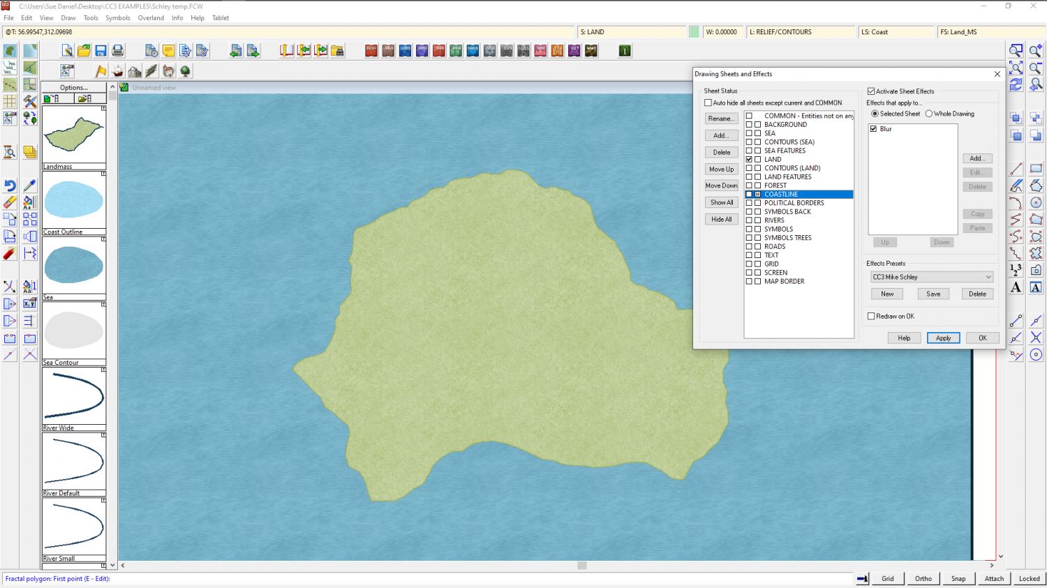
I haven't got a default CC3 style map lying around I can just open, and I'm a little tangled up with 3 instances of CC3 open at the same time right now, but if you click on the LAND sheet of the default style you should be able to copy the sheet effects on that sheet, copy them, and paste them into the Mike Schley map.
As for the rivers - I believe they are drawn the same way in both styles, though the colour might be different. You can find out what colour the rivers are in the default style using List from the Info menu, and then change the properties of the rivers in your MS map using the Change Properties button on the left toolbar.

-
Show All Text Insertion Points
It's not the insertion point, but the baseline of the text. Click on the bottom of a letter and you will see.
