Wyvern
Wyvern
About
- Username
- Wyvern
- Joined
- Visits
- 3,237
- Last Active
- Roles
- Member
- Points
- 5,515
- Rank
- Cartographer
- Badges
- 24
Latest Images


-
Community Atlas 1000th map Competition - with Prizes [August/September]
Map four of my ten small settlements is Toresk Village:
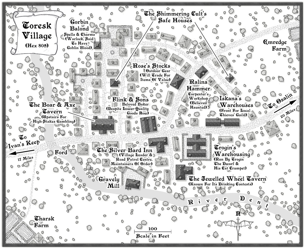
I've updated my WIP topic with this map today too, and there's a higher-res version in my Gallery as well. The FCW and PDF notes follow:


-
Community Atlas 1000th map Competition - with Prizes [August/September]
Map two in my group of small settlements is for Bruga's Hold in Hex 403:
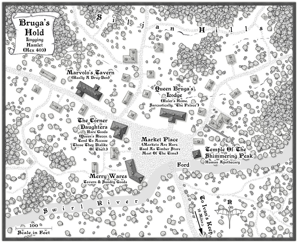
I've updated the notes in my WIP topic about this set as well, and there's a larger version of the map in my Gallery too. Meanwhile, the FCW file and PDF notes are here:

-
Community Atlas: Map for the Duin Elisyr area, Doriant
So at last, everything's ready, and has now been submitted to the Atlas. This is the final version of the Evth Pass map (higher res version in my Gallery):
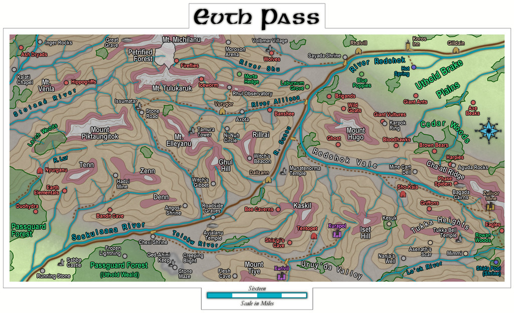
Quite a journey from those three rolled dice that began it all!
Next time, the deities of randomness seem to be dictating a return to Peredur, in its northeastern part, somewhere in the Godtagel area, apparently...

-
Community Atlas: Petroc Hills area, North Central Alarius
The basis behind the Inkwell Ideas setting that I wanted to reuse here was as a sort-of druidic experimental station, a series of caves magically enhanced to allow the growing of normal surface food crops underground, protected from conditions outside, and defended by a group of willingly-summoned elementals. This seemed very suitable for this area, with its short summers and long winters, and although not illustrated specifically on the map, the notes for the area indicate there are a lot of other small caves across the Petroc Hills, which might also be used in future, if the experiment here works. It's all being done in secret for now though, in case something goes wrong, hence the defences. I tweaked a few items, added one or two more, and decided, partly based on the general layout, that it had originally been one of the old Hill Dwarf mines of the district. It's often amazing how much just seems to come together from a couple of initial thoughts in this way. I even contemplated having it be set-up just for growing grain crops for a different flavour of whisky at one point, but decided against that eventually. If they can grow the food underground, that'll leave more field space for cereal crops to make whisky outdoors, after all!
As indicated earlier, I'd be opting for the Jon Roberts Dungeon style from Annual 54 for the mapping of the Caverns, and although I had to make use of a couple of DD3 symbols to round-out what was needed, most of what was required could be found, or repurposed, from that style alone. So to the map:
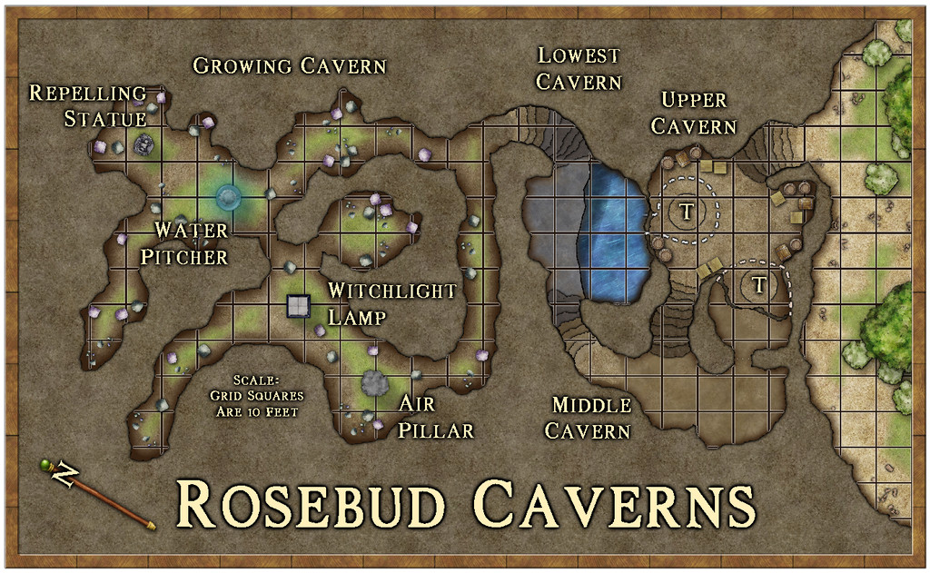
The earthy colouring worked to reinforce the whole "druidic growth" concept, and it's a style that works well in showing what's outside and inside, as having greenery, bushes and trees available. To keep the interior clear enough for GM use though, I decided against adding specific plants there, just some fungi (which are one key aspect of the Growing Cavern area), and also went with a quite strong scaling grid, as distances here can be important. I continued the grid over the water, because half of Lowest Cavern is underwater, and characters could well end up stuck there (the underwater areas including the annexe chamber beneath Upper Cavern - the dashed white lines show bits of the lower caves under Upper Cavern). Those circled "T's" in Upper Cavern are indeed rotating Dwarf-made round trapdoors, dropping down to the barred-cell cave off Middle Cavern, and into the plunge-pool off Lowest Cavern. In Growing Cavern, the four labelled statue-like features are the magical items that keep the place functioning, as explained in the map notes, and which again have vaguely elemental aspects to them.
Probably the biggest mapping challenge was constructing the steps, which did start to feel a little as if they were having to be carved from the native stone by hand for a while! Each has to be on a separate sheet to enable the effects on them to be adjusted to create the illusion of showing which are higher and lower, with the added pain of trying to hide the dark glow at the "back" edge of the top step. They're not perfect, but to my eye at least, they seem perfectly functional to show what they are on the map.
One further troublesome aspect was the abysmally slow redraw times when using the "Trace" command here, because the caves are all drawn as fractal polygons. For reasons I won't pretend to understand, the command insisted on repeatedly following the entire Caverns outline every time it was used, regardless of which way I'd told it to go, or how small an area I was trying to trace. There wasn't any choice though, as aside from needing different floor textures in places, I had to create masks to Color Key cut-out the unneeded segments of the grid, due to the way caves are drawn in this style. Worked in the end, but quick it ain't!
A useful feature of the Inkwell Delver dice set is that one of the six dice is designed to show entrances to the subterranean systems. So for the first time in this mapping project, rather than simply devising a suitable way in to the dungeon or caves separately, the first segment of this map - from the exterior through to that first long, straighter, northeast-southwest passageway in Growing Cavern - came directly from the dice design. We'll get the chance to see another of these entrances in action next time.
As for next time, a new continent beckons, the largest on Nibirum, Doriant, and a location somewhere in the Duin Elisyr region...

-
Community Atlas: Monseignor District in Kentoria
The reason I opted for a monochrome style for the overland map was that I'd already chosen the Annual 48 Dungeon Black & White style for the underground map. Even if technically, it's not truly underground at all, as it's set into the gigantic dolerite mesa-like rock pillar which is what's actually called "Melgore", with its entrances at surface level on the north side of the pillar, by the rocky beach leading down to the nearby River Wisper, and which extends up into the pillar a short way (a total of less than 40 feet, 12 metres, given the pillar is roughly 500 ft tall, 150 m). Thus the Necropolis map:
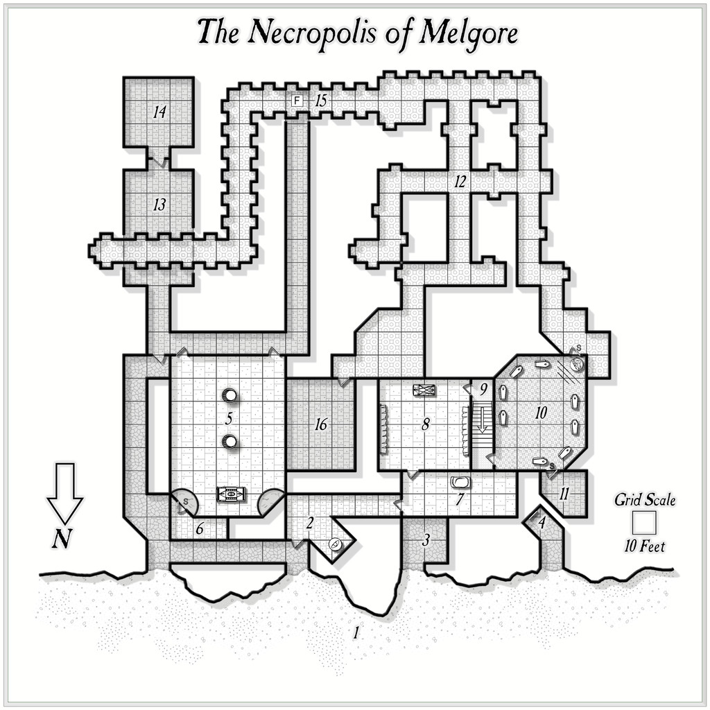
There are, of course, PDF and text descriptions for both maps to go into the Atlas, to provide more flavour and notes on what's where, and what's going on in both. Some of these ideas came from various random design lists, published and personal, although I also drew on inspiration from the book description available from Inkwell Ideas for the "Crypts" dice set used to create the Necropolis map, adapted and amended somewhat here.
Plus the original dice-map was amended, to remove unnecessary blind passages that didn't link together, and to stop the whole from having too much of a "geomorphic dice edge" look in places. In other sections a few new features were added - corridors or rooms extended, shortened or linked, with new doors or secret doors added as well, as my thoughts about what was here developed during the whole mapping process, much as normal.
I wasn't sure at first about leaving the wall shadows visible into the surrounding rock, although this is what the style was designed to show. However, I became quite attached to this look during the mapping, which, with the crispness of the style, gave me the impression of looking at a map set into a sheet of crystal-clear glass. I did a brief experiment with a wall mask to hide the shadows in fact, as part of the process in concealing the bits of the grid that weren't needed, but found that hid too much of the wall lines, and made the whole thing look rather flat overall.
Higher-res copies of both maps are in my Gallery as well, for those wishing them.
My intention is to keep trying out different mapping styles during this project, albeit I am inclined to attempt to retain a stylistic theme where two (or more) maps need to be nested into one, as in this case.
If all goes to plan, I'm next heading off to a continent that's eluded me till now - the tropical heat of Kumarikandam!


-
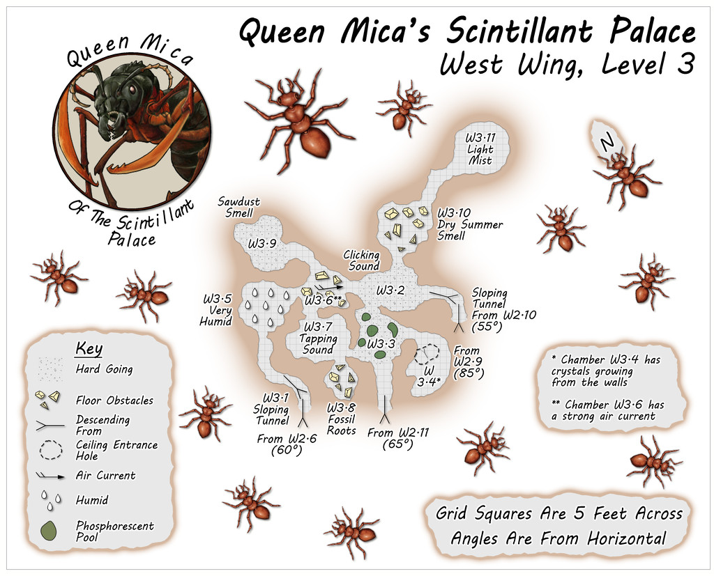
Community Atlas: Queen Mica's Scintillant Palace
As mentioned, the four Palace Wings were based on a different option than the "Carapace" booklet's system, hence none of these maps have schematic drawings beside them. Each was instead based on images posted by various people on the Dwarven Forge Discord, and from layouts shown in several official company videos available on the Dwarven Forge YouTube and Twitch channels. All used items from the cast modular terrain "Burrows" pieces made by the same company.
The nature of such modular terrain items does make for more rectilinear layout patterns than those generated by "Carapace", although this would make it possible to set-up layouts on the tabletop, for those owning such Burrows pieces, that are similar to what appears in the Palace Wing layouts overall. However, alterations were made to the sizes, shapes and orientations of the tunnels and chambers at times as shown in the final maps here and in the following posts, so exact matches would not be possible.
Despite this change, the nature of each chamber in the Wings was again randomly decided using the Appendix 2 tables in "Carapace", with occasional amendments, since these offer the potential for a number of interesting variations and features.
The selected layouts were combined and chosen to loosely match the look of the outlying parts of the Palace on the Illusory Level 1 map, meaning the layouts delving deeper were placed in the western and northern Wings, representing the parts of the surface sketch where the taller buildings and towers were.
First then, the West Wing, comprising three main vertical levels:
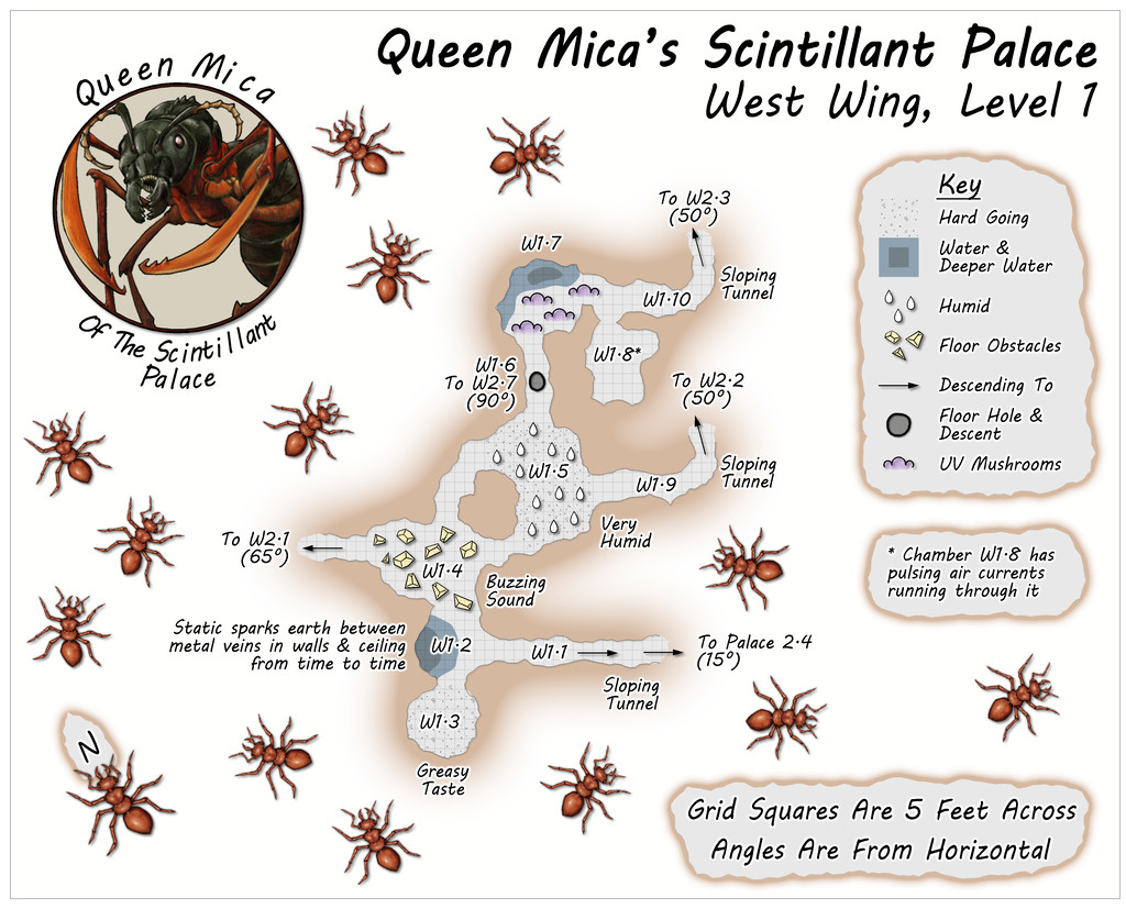
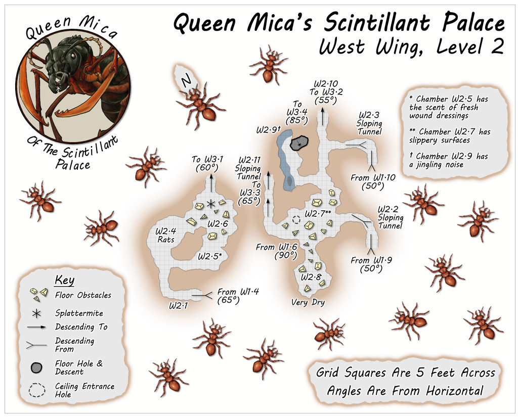
All the Wings have just a single connection to the outside, in each case by a link back to either Level 2 or 3 of the main Palace. In this Wing, that's on Level 1 of this trio, where Tunnel W1.1 leads back down to Chamber 2.4 on the Palace's second Level. This layout was based on the extensive, multi-level "Demonic Depths" Build of the Month video from May 2020 by Dwarven Forge.
The idea is that the Wings are generally less-used than the main Palace, so few of the areas in them have suggested-use labels on the maps (albeit some additional comments are provided in the accompanying separate notes files).
![[Deleted User]](https://secure.gravatar.com/avatar/c75d9a245b74d9c59be0999ea81ca541/?default=https%3A%2F%2Fvanillicon.com%2F92add7f8c954488718110edc4896ad39_200.png&rating=g&size=200)


-
[WIP] Community Atlas August Mapping Contest: Cloven House
Although I've already posted about this in the contest topic, to round-off this WIP topic too, here are the final versions of Cloven House, without and with its secret Cellar cave, now with added cupboard under the Cellar stairs:
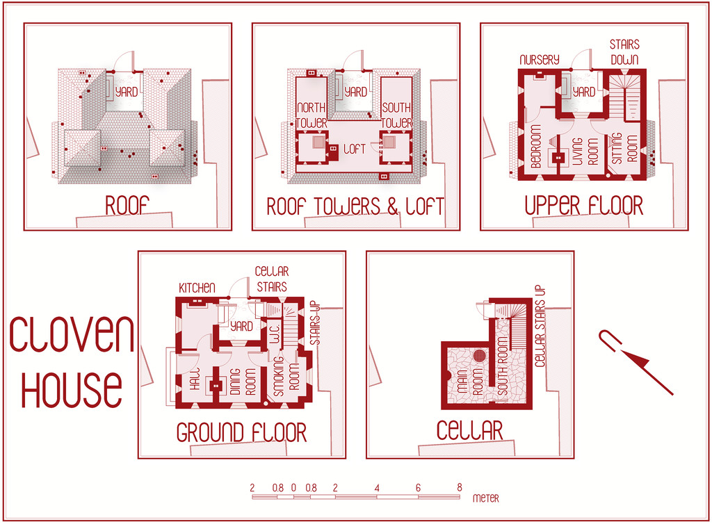
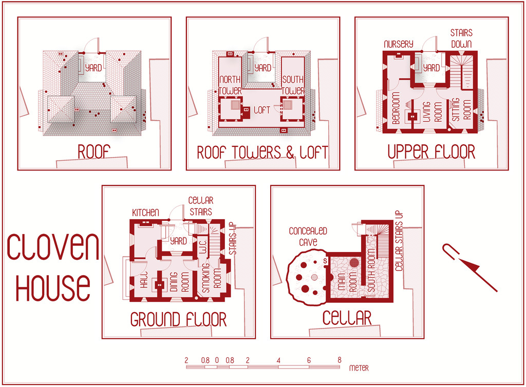
For those who might be interested, and again something that's in the contest entry topic too, I've attached here the PDF notes for the map, which will be in the Atlas version in the fullness of time, for those wanting an early preview of this little haunted house:
Do be aware that there's a hint of "adults only" about a couple of the potential apparitions and other ghoulish elements in these notes. Nothing too salacious, just something to be aware of.
Incidentally, anyone thinking I might have abandoned my preference for random design mechanics in devising my Atlas maps in this instance, might be reassured that there were hints of that in selecting what ghostly items to pick from in constructing this description (I have a long list drawn from numerous past sources and ideas!). Such a mechanism was used less here than in other features I've designed previously, however.
And good luck to all the other contest entrants, especially those struggling to get things finished by the deadline!

-
Community Atlas: Embra - Enclosed Places
The final Enclosed Places map condenses the remaining five Places, all streets, into a single drawing:
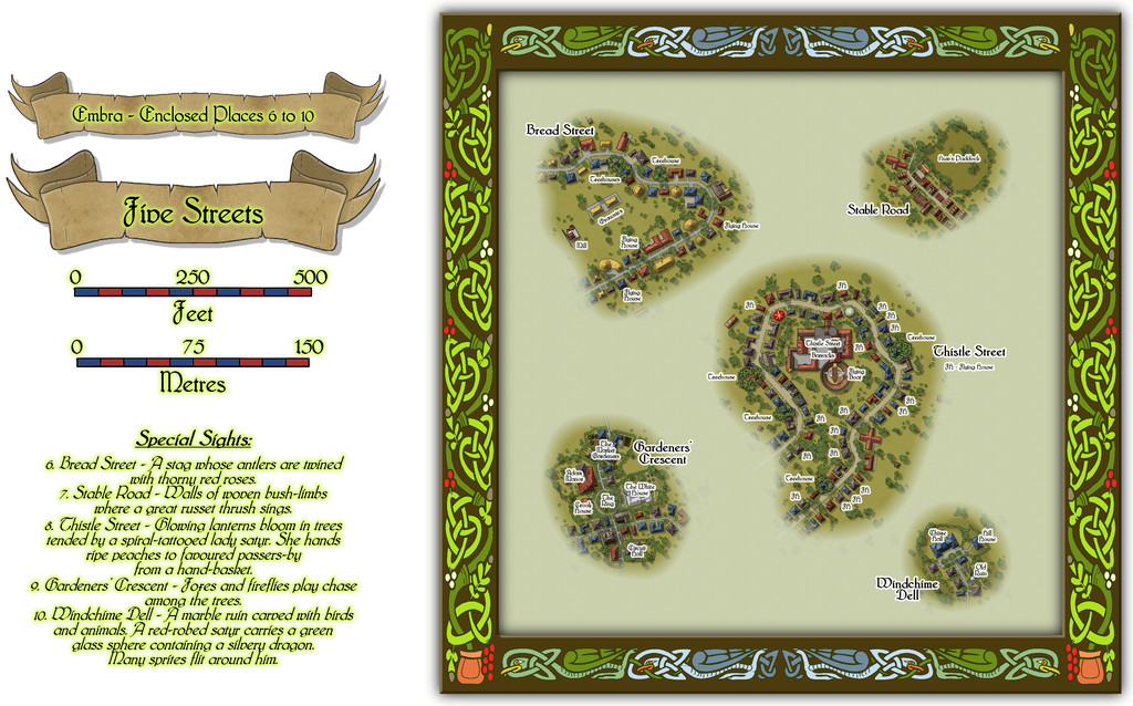
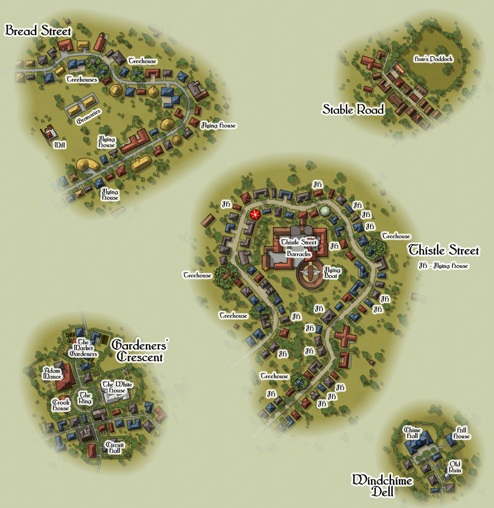
Lots to see here, so let's try a closer view of just the streets:
All the streets had to be designed in a rather different way to the other Places of course, as there were no Judges Guild products that provided plans for such things in isolation. As I noted previously, instead I reworked a set of tables for randomly generating caves and mines from another old Judges Guild text to decide on their lengths, widths, types and layouts, although that system ultimately was more "me" than "JG". Once the base layouts were designed and drawn into the CC3+ map, the streets were redrawn as proper CC3+ streets of the appropriate width and character, and then the CD3 random street options were used to populate them with a range of houses suitable for their overall names and natures.
The streets I came up with were often quite curvy, and the CD3 random street tool isn't too keen on curves and turns, and it can't really cope with junctions at all, so some of the random properties had to be moved, or removed, or adjusted, and sometimes redrawn using a combination of the base shapes that had been generated. Occasionally, some were swapped out for symbols, particularly where I wanted specific or important structures to be. I also decided early on that it wasn't going to be practical to provide interior drawings for all the properties involved - there were simply too many, and that ran the further risk of making them too much alike without a lot of care. I did contemplate doing interiors for selected properties, only to finally decide against that too. So if you need interiors, you'll have to come up with your own for these!
I'll not go into detail here as to what some of the items on these mapped streets are. The PDF and text files in the Atlas should help in that respect. However, it is worth drawing attention to the most significant structure, the Thistle Street Barracks, home to the Knights of the Thistle, Embra's military and police-force, in as much as any Faerie settlement needs such things. These Knights are not entirely my own invention either, as real-world Scottish knights of the realm are known as "Knights of the Thistle" too, though Embra's are naturally of a more magically Faerie kind.
As with all the other individual Places, the idea is these streets can be linked as loosely and in whatever ways GMs may desire to create fresh interpretations of Embra city.
And this is only the first collection of Places in Embra. There are six more such sets still to come!

-
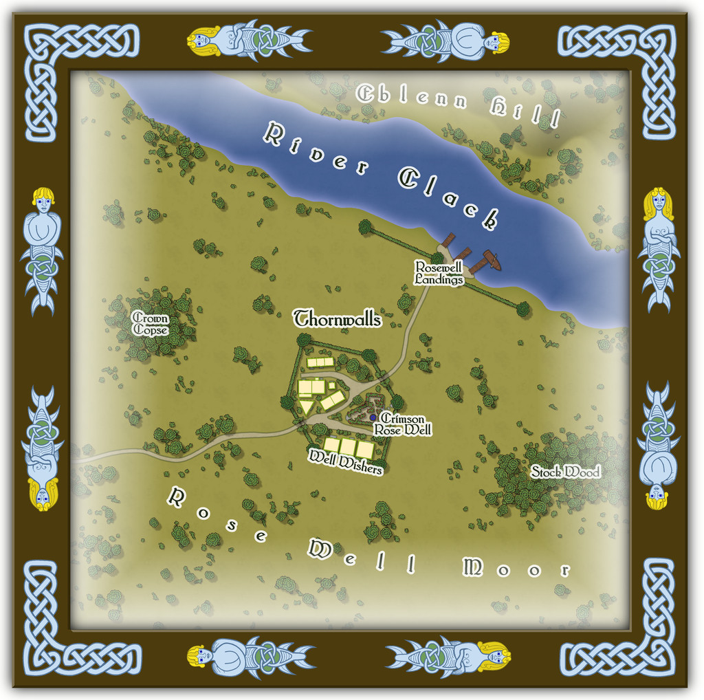
Community Atlas: Embra - Watery Places
Next is another curiously isolated hamlet, this time closer to the River Clack, so it appears on the map as well, although the hamlet's existence is presumably due to the fortuitously-discovered, naturally enough magical, Crimson Rose Well:
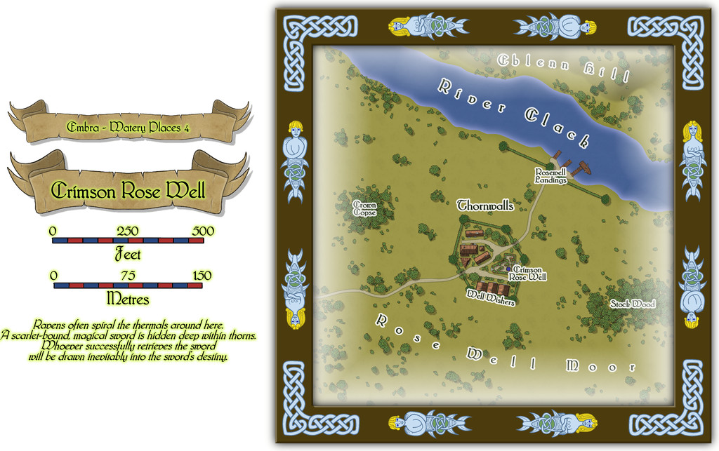
As might be guessed, the odd appearance of the settlement and its riverine landing-stages resulted from the original random base map being one showing a small castle and a defended landing on a river. This being Faerie, the defensive walls become high "walls" of thorny vegetation sporting great, heavily scented, crimson rose blooms, and the castle becomes a hamlet-sized community dedicated to looking after the Well and those who come here seeking its magical aid. The fact there could be a powerfully magical sword hidden away within the thorns somewhere (from the featured text) merely adds an extra note of interest. Plus GMs can have fun accounting for why this bit of Embra is so apparently isolated from the rest of the city it needs a substantial landing area all its own on the Clack!
Buildings on the non-streets maps means interiors, and again these are all of just the one storey:
Some of you may recall Eblenn Hill has featured before among these Embra Places maps, as it's the substantial hill the first of the Enclosed Places was set upon, the Freed Haven Floral Garden. Whether the version here is the same or not, and how - or if - it may relate to the "other", is left for GMs to decide.
-
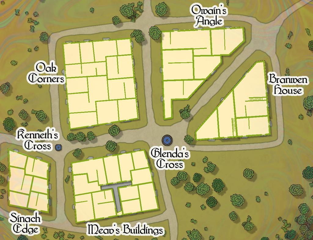
Community Atlas: Embra - Villages
Embra - Winterset in the southwest moves things towards a somewhat different nature, with many clustered properties, and no River Clack. Water comes instead from a pair of well-fountain pools at two midline crossroads, while the not-quite enclosed areas of Aine's Pastures are connected by a bridge that arches over the northern trail, a particularly obscure - thus clearly Faerie - feature:

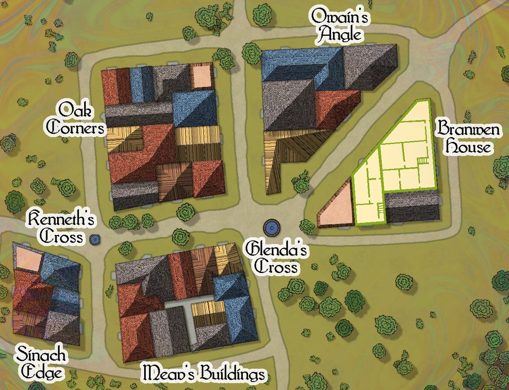
The interior views show what the layout of the properties really is, although there are many fewer two-storey buildings, as the lower image here demonstrates: