


Wyvern
Wyvern
About
- Username
- Wyvern
- Joined
- Visits
- 3,239
- Last Active
- Roles
- Member
- Points
- 5,519
- Rank
- Cartographer
- Badges
- 24
Latest Images


-
Live Mapping: Herwin Wielink Overland
I've done a lot of mapping with this style (and indeed I currently am again), largely because I like it so much. I picked it as the basis for the 40 maps in my ongoing Errynor mapping project for the Community Atlas, after all! It'll be nice to see it get some live-streaming love and attention though!
I find it actually has quite a good range of symbols, more so than some styles, which, in combination with the range of textured fill options and colours, is what makes it so attractive for me.
Of course all styles could always do with more symbols - as many of us have commented here before 😁
[And I think we all also know in most cases, that's not going to happen!]


-
SS6 - free imperial grid
Yes please, another vote in favour of having the grids as options in the final SS6 - imperial and metric!


-
Britannia (Parchment World)
This is a very impressive and detailed map (speaking as someone who's mapped various parts of these same islands at various scales over many years)!
Appreciate this is for game use rather than historical precision. However, the lines of both the Antonine and Hadrian Walls are a little off their actual ones - Hadrian's Wall follows along not far from the north bank of the Tyne in its later eastern stages, and ends at Wallsend (surprise!) on the north bank more or less opposite Jarrow on the south bank (at this scale), for instance. Not sure how important this may be for your purposes though 😊.
Seeing what else has been labelled, it may be worth thinking of adding some names for the more important old Roman roads, as some at least were still in use by the c.560s CE and later (some major roads still follow their lines today), and a few of the surviving names seem to have their origins in the Old English/Anglo-Saxon language.

-
World of Myirandios - Mivlis-Gyaflaggio region (400 x 400 km)
Lot of detail there, certainly!
If this was going into the Atlas, I'd suggest a rethink on some of the labelling, as to my eye much of it's getting lost amongst the terrain in places (using the larger Gallery version to check this). Indeed, there are labels visible on that version that I didn't spot on the Forum one. Since it's for personal use, that's probably less of an issue though!
![[Deleted User]](https://secure.gravatar.com/avatar/c75d9a245b74d9c59be0999ea81ca541/?default=https%3A%2F%2Fvanillicon.com%2F92add7f8c954488718110edc4896ad39_200.png&rating=g&size=200)
-
The Creepy Crypt project
Dee-licious! 🍳

-
Panzer sample thread
So far as I recall from modelling the 8- and 6-rad armoured cars (i.e. also from period images and information), the aerials were fixed in position, and at a height above the turrets all the time. These are the early-war "bedstead" frame aerial types, not the later war smaller "star antennae" which were retrofitted to some models, incidentally.
Oh - and belated congratulations on your ascension to Master Mapper status @Lillhans ! Very well done!


-
[WIP] Community Atlas: Snakeden Swamp, Lizard Isle, Alarius - Dedicated to JimP
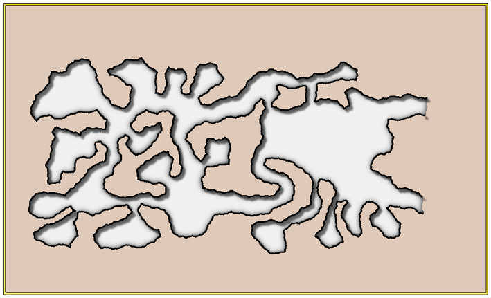
Having decided to add an underground map for the Snakeden Hollow one, showing to where those two cliff entrances lead, an extra floorplan was needed from the Inkwell dice designs to accommodate it. I opted for a caves-only layout, and because I already had in mind what the main critter was going to be in there, it needed to be a sufficiently large and interesting layout too. The size and shape of Temple Hill had already indicated a two-dice pattern was going to be more likely, so I dug through the options available for cavern layouts that hadn't been used already, or weren't already planned, and rolled a few dice, before finally selecting one die-face each from the "Lairs" and "Spellunker" dice sets.
That pattern was sketched onto graph-paper as usual, and then scanned-in ready to be redrawn in CC3+. This first image (reduced-size at this point, as typical from the above) shows the basic wall lines over that hand-drawn scan, done using the DD Pro Dungeon style (which, much as the other "early" styles used in this map-group, turned out to have more sheets and effects present than originally expected).
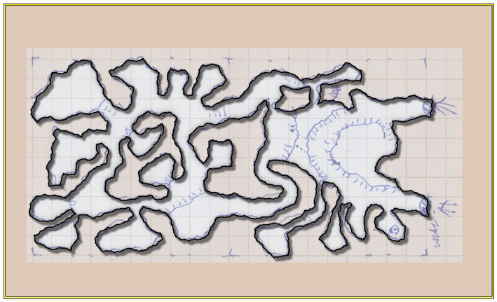
As this indicates, there are going to be various internal levels within this single layout, which promises an increasing degree of complexity in the map-drawing. I feel an attack of the sheets (and more effects) could be imminent!
There are obvious elements in need of adjusting already. Both entrances have solid wall lines across them, for instance. Plus of course, as anyone who's used this drawing style may realise, the wall lines don't just draw themselves, as they're half of the basic caves drawing tool with the floors (hidden here for clarity of the scanned JPG). Oh and that word in the lower right corner actually says "Well", as that's what that circle-and-dot symbol nearby represents. I couldn't read it either, when it came to it...
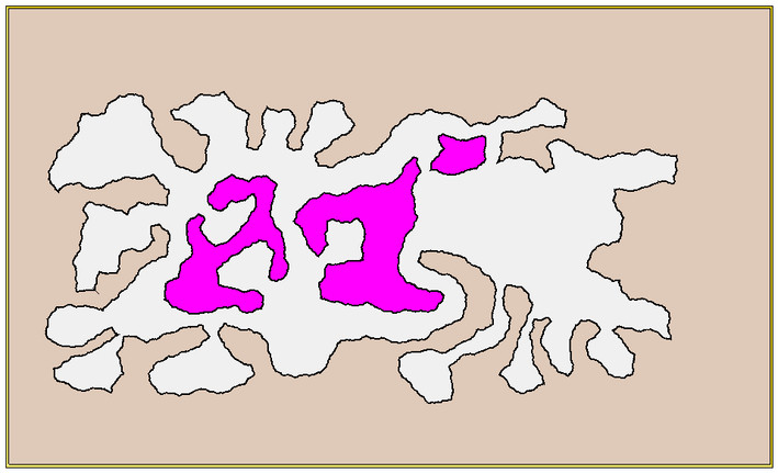
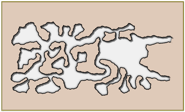
As the perceptive may appreciate from this, some CC3+ magic has already been applied here, laying down Color Key polygons for the internal solid-rock elements, by copying the relevant wall lines to the Floors sheet, and converting them to filled polys of suitable colour. The same map without the bitmap and with the floors:
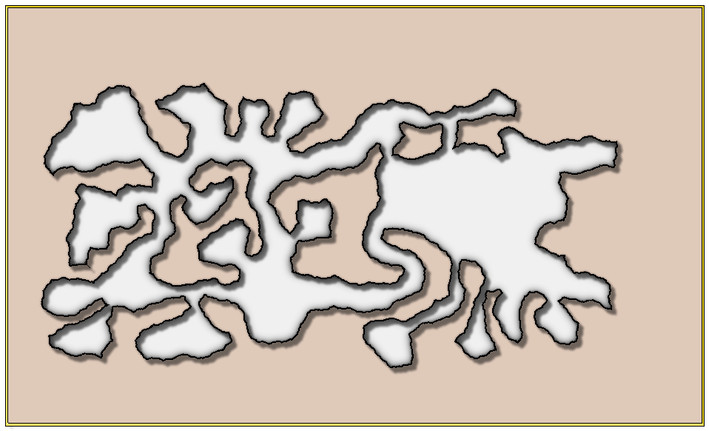
and then with the effects turned off:
Next task was to break the wall lines for the two entrances, and then add a series of masks to hide the unwanted segments of wall shadow in the solid rock. Not sure the shadows will remain ultimately. However, the masks help clean-up the overall look somewhat:
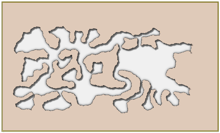
Well, actually a bit too much, as the wall lines are now almost invisible. I could just have thickened up the lines, although that starts to encroach into the available space in the caves, so instead, I just copied the wall lines onto a new sheet above the mask with no effects on, and thickened those up a little instead:
As is probably obvious, the map layout has been deliberately off-centred to allow a sliver of the exterior to be added along the right-hand edge, hence why the wall shadows at that end haven't been fully masked yet. When I dropped-in the exterior JPG scan though, it was immediately obvious that both tunnels needed extending further, to better allow the cliff line's curvature to fit to the interior design, so that was the next step:
That proved more problematic than expected, as for reasons I never got the bottom of, while extending the floor was simple enough using the "Edit" function for the cave drawing tool, as was editing three of the four wall lines with a suitable new drawing tool, the uppermost little new wall section would not connect to the rest of itself after completing the edit process. The line drew just fine there, but as a separate entity, something I only discovered when copying the lines to the above-mask sheet. I tried redrawing it, with no better success, and as it looks OK, decided to just leave well enough alone!
It did though take rather more time than expected to get to this stage, so that's where we'll have to leave it for today.

-
New Commission. Ghorfar
I may be misreading the hand-drawn version, but aren't the trees meant to go right across the mountain peaks as well? On the CC version, it looks like they're almost all bare rock currently (judging only by the coloration, not whatever that grey fill style is meant to represent).

-
Community Atlas: Dendorlig Hall - A Sort-Of D23 Dungeon for Nibirum
Thanks for all the comments, "likes", and so forth folks! Much appreciated.
"Dendorlig Hall" it is then (and topic title amended to reflect the fact)! Please reserve it for me in the Atlas @Monsen, if not already!
@roflo1 - Yours is another fun dungeon generator, and one that for some obscure reason hadn't come up among my Google searches previously. Looking through the list you have there (for random dungeons only), I note several links are broken now, and one of the sites that still exists, Dizzy Dragon's, isn't an "https" site, which sometimes get flagged or blocked by certain browsers/browser settings now. Might be worth reviewing and amending the whole page now?
No thanks, Julian! I prefer to set my own challenges! But this might be an interesting project for another mapper here?
@Loopysue - Maybe just one of the smaller twelve-room dungeons might be a possibility for you though? Might even fit to your creation schedule if there's a fresh dungeon style coming up later this year that will need a sample map preparing, say...
Thanks for the comment re Scott's "Darklands" map too, Remy. I've been checking over the maps and descriptions for the Malajuri area since I last noted anything here, and as you wrote, couldn't find anything suggesting direct links to the surface world, though there is a somewhat "compartmentalised" layout to my blue dungeon map already, which could suggest a possible faction or two from the Darklands might have established an outpost or two here. I'll have to think about this further!

-
Community Atlas: Embra - Enclosed Places
Enclosed Place of Interest 3 is the Floating Dale Park:
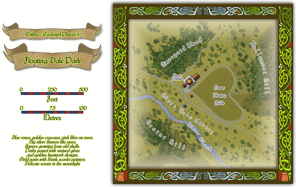
This can be used as a typical real-world park, with opportunities to wander around, or play outdoor games on the central Playing Fields, whose unusual shape may call to mind that Faerie outdoor games and sports may not be quite those familiar from the Mortal Realm.
There are a handful of surface-level buildings scattered around the map's centre, as one of the map toggles will reveal:

These include the Pavilion, where equipment for playing sports and games is available, as well as a restaurant in the central octagon beneath the building's dome. And yes, some of the vegetation is actually intended to be of living glass in Glass Tree Forest. And again yes, those ARE bridges made from rainbows over the River Clack. As ever, the text and PDF files will explain a little more about both facets, and others, from this map. In case this seems not very "Enclosed", there ARE boundaries to the Park which are deliberately less obvious than some.
