


Wyvern
Wyvern
About
- Username
- Wyvern
- Joined
- Visits
- 3,238
- Last Active
- Roles
- Member
- Points
- 5,517
- Rank
- Cartographer
- Badges
- 24
Latest Images


-
Install Order?
Can't really do more than reiterate what Sue's said already re you and your mother's ongoing situation, and to hope things settle for you very soon.
With CC3+, I think we all feel for you too. Even a short spell away, and I find I've forgotten something critical... If time and circumstances allow, it might be worth checking-in on one or two of the live PF mapping sessions on YouTube - or checking them later as VOD - as Ralf usually goes through all the basics of setting up a new map, as well as whatever the session's about, for instance, which might help get you back in the swing of things a bit quicker.


-
Community Atlas - Forlorn Archipelago - Poncegraf Village - Church
For the Church, the pillar shadows could use some adjustment, as right now, they're passing over and through the walls, which is confusing.
On the upper floor (which might benefit from labelling as such), the stained-glass window patterns thrown on the floor need adjusting, so they cover only where the wooden flooring is - where they shine into the air beyond, there should be nothing.
Additionally, not all the windows should be showing these at all on either floor, only where the light will be shining directly through them, and that should match with where the floor shadows lie as well.
It might be helpful to add dashed or transparent lines on the lower floor image to indicate where the upper balconies are on the lower map view.
![[Deleted User]](https://secure.gravatar.com/avatar/c75d9a245b74d9c59be0999ea81ca541/?default=https%3A%2F%2Fvanillicon.com%2F92add7f8c954488718110edc4896ad39_200.png&rating=g&size=200)
-
WIP tavern
While the size may seem wrong, by a strict comparison with some medieval European structures, this isn't for medieval Europe, it's for fantasy D&D, and is close to the scale size for this specific tavern as shown on Mike Schley's map of Saltmarsh in the Ghosts of Saltmarsh scenario book (Wizards of the Coast, 2019), assuming five-foot grid squares here. The appearance isn't quite the same as on that map, but this is an adaptation after all, and although there are a number of designs for the Wicker Goat Tavern online, I don't think there's an official D&D version, so some leeway is to be expected.
In the original adventure (The Sinister Secret of Saltmarsh, TSR's Module U1, from 1981), you were expected to create your own version of the town from scratch - there are a few guidelines for key points, such as Point 4: "Decide where the characters could stay when resting in the town between adventures (the best inn? the only inn?); draw up a tariff (list of expenditures) for their accommodation and food." But that's as close as we got to a description for the inn/tavern, which didn't even get a name back then!
That's not to say such points should just be ignored necessarily, and the heating and access points are useful considerations. However, if the final tavern is meant to fit to the size of the official Saltmarsh map, this is close enough to work for that.


-
Snowy lands
Looking at the symbol and terrain use here, I think these could be used to create an illusory city too, or a literal ghost town, perhaps with some additional colour overlay effects, and perhaps some transparency about the symbols (less sure about the latter point, however). Or indeed a city of glass.


-
[WIP] Community Atlas August Mapping Contest: Cloven House
Today, I've managed more, and relatively speaking, things have moved on some way from that. This is with the CD3 rooftop bitmaps still showing:
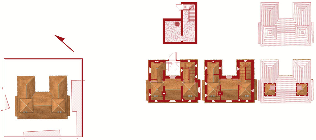
and this is it without:
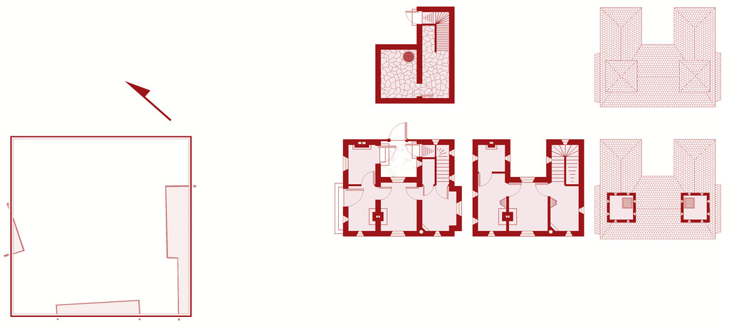
Clearly, there's still lots to do - the roofing needs adding over the lower floor extension and porch on the upper floor plan, for instance, and other items need adding and tweaking in places. Such as a scale and the labelling! Plus I've decided life will be easier to reorient the north direction than the floorplans, and have rotated the surrounding buildings (or now technically building blanks) to suit that.
At some point, I'll need to work up some notes to go with this for the Atlas of course, though the map has the sharper deadline, obviously. The observant may notice the grille in the cellar. The local ghouls like to use the fabulous sewer network to get about unseen, especially after they created tunnels between the sewers and the cemetery beyond the city's northern wall. The ambiance of this haunted house - I'm thinking now "Cloven House" currently - and the fact nobody comes near the place ordinarily, makes it ideal for their feasts!
-
Good sizes for fantasy cities etc
As Jim said, there's going to be a lot of personal preference involved here, heavily dependent on how you see your world setting developing, what types of civilizations exist in different places there, as well as how much time and effort you have available for designing and mapping it all.
Plus you're really asking two different, if related, questions - 1) the number of key buildings desirable for different types of settlement, and 2) what the appropriate size of different types of settlement can be for different types and numbers of special buildings.
The question of settlement sizes has come up on the Forum here before, and you might like to look over the comments on these two topics, both of which coincidentally came-up in late 2018:
Looking for advice on starting Village/Town/City size
There are also various systems for designing RPG settlements available online, some paid for (on sites such as DriveThru RPG), some not (such as blogs), as well as a number of random design systems, such as those on the Watabou site, although those provide primarily maps, rather than lists of the specific places you indicated as of interest.
Those should get you started at least, or perhaps help clarify what it is you want (or even don't want!) from such systems, from where you might feel more confident about creating your own settlement design system.
Good luck!
-
Seven Pines Lodge (keep it simple stupid)
Now everyone should have a good idea where to poop after experiencing a Eldritch horror.
Yeah, as Don says that's not really an issue for anyone who's ever played Call of Cthulhu. Surviving long enough to actually get to that point, now THAT'S the tricky part 😉.
-
Wishlist for CC4
I'm not sure such a sheet would have much utility for all mappers. I've never had any need for such, but then I plan or sketch all my maps out on paper roughly before-hand, and simply use a bitmap scan of the hand-drawn version as the template in CC3+. If I need construction lines while mapping, as does happen sometimes, it's very easy to simply draw and then delete them once I'm finished with them. If I think I might need them again later, I save a separate copy of the FCW map file for that purpose before deleting them.
If you do find these are important, it's easy enough to create a Sheet on its own Layer (you can only freeze Layers, not Sheets, in CC3+) for use in the way you've described. If you're likely to be doing a lot of similar maps the same way, you can always save that as a personal set-up for the future having done it once. That way you can set the name and placement in the Sheets list as best-suits yourself.
You'd have to hide the Sheet before exporting, but you'd likely be doing that anyway to check the map without the construction lines getting in the way prior to that stage.
I doubt it would ever be possible to set up any single Sheet in CC that would somehow automatically "know" what colour you might expect different kinds of drawing entity to have. There are just so many variables involved - all of which you can adjust to whatever you require in CC3+ now, as Jim noted. If you might regularly require specific items of particular line thicknesses, styles and colours, it would be very easy to keep a sample of each on your "Construction Sheet" (or another Sheet set aside for such samples) that you could readily access using the "Draw like..." or "Extract properties" commands.

-
World of Myirandios - Mivlis-Gyaflaggio region (400 x 400 km)
Lot of detail there, certainly!
If this was going into the Atlas, I'd suggest a rethink on some of the labelling, as to my eye much of it's getting lost amongst the terrain in places (using the larger Gallery version to check this). Indeed, there are labels visible on that version that I didn't spot on the Forum one. Since it's for personal use, that's probably less of an issue though!
-
The Creepy Crypt project
Yet still no cat... 😁🐈️


