


Wyvern
Wyvern
About
- Username
- Wyvern
- Joined
- Visits
- 3,238
- Last Active
- Roles
- Member
- Points
- 5,516
- Rank
- Cartographer
- Badges
- 24
Latest Images


-
Sticky Note Dungeon
But one corner isn't curling-up where the glue hasn't stuck properly, unlike the real things 😉!


-
Panzer sample thread
Excellent! And now without the canvas roof? 😁 And then with the anti-aircraft guns mounted on the rear. And...
You know Forum folks - we ALWAYS want more symbols!


-
[WIP] Community Atlas, 1,000 Maps Contest: Villages in The Whispering Wastes of Haddmark, Peredur
Halfway point, or map five of the ten, if you prefer, is reached via Hex 1105, Osalin Village:
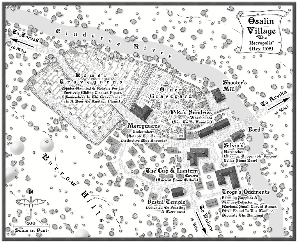
One interesting aspect for me as mapper with this sub-project was how readily the places each developed their own character, partly a result of their broader map setting, partly thanks to whatever features the Shadowdark random tables had come up with. In this case, there was the chance to map an unusually extensive area of burials, an aspect which truly defines the settlement, given that the area occupied by the dead is greater than that of the living village. Everything there was placed individually, to make sure things were never too neatly-ordered, although it's perhaps best not to peer too closely at what some of the repurposed symbols involved as the grave markers actually are! What's important at this map-view is the shape, texture and the shadows (or equivalent effects - there are some "Solid 10" shapes with variant Lighted Bevels in places, for instance). While time-consuming, it was rather satisfying to see the whole area growing in a more or less organic manner.
I'd already decided there might be hints of connections with a couple of the barrow-fields in hexes some way from the settlement on the Whispering Wastes area map, so adding a few more Solid 10 bevelled shapes for a few barrows closer-by seemed simply a natural adjunct. What was perhaps more surprising was the random tables provided by-chance an undertaker, properties hinting further at the ancientness, not to say weirdness, of the setting here, haunted warehouses and a little old temple suitable for hosting celebrations for the deceased (and anyone else at other times, of course). I've mentioned before, there are times when you start to wonder just how "random" these things really are! All I needed to add was a mill, a few contours and those barrow-shapes.
Onward now to the second half of the ten!


-
City locations
Might want to tweak the angle of the seating a little for the rows nearest the outer walls; otherwise, patron complaints about stiff necks can be expected!
Will there be upper levels too?
-
Dhakos, The City of Spires - Watabou Cities Annual
Well this is weird, as I've just dropped-by the Forum here following a lengthy discussion on one of my Discords with someone about the old Chaosium versions of the "Stormbringer" RPG, a few minutes ago!
Not sure if it'll help with your spires query, but I had to draw my own shadows of not dissimilar form for one of my Atlas maps a while back, the Thalassan Castle Ruins. The FCW might give you a further pointer or two, perhaps. Or perhaps not! Good luck, regardless 😁

-
Several maps for (random forest) encounters
The default sun position in CC3 is from the north west... even though the sun is only ever in that direction for real if you live in the southern hemisphere.
Not quite true, Sue, as from the northern hemisphere in summer, around June-July, the Sun sets in the northwest too. From much of Britain, that's around or indeed north of, true azimuth 315°. 😎

-
Ancient maps
That 22-foot Roman Empire map is the Peutinger Table, aka Tabula Peutingeriana, and the Wikipedia page includes a high-res complete image of the whole - may take a while to load, however, as the full-size JPG is about 15 MB. This is the direct link to that Wikimedia image.

![[Deleted User]](https://secure.gravatar.com/avatar/c75d9a245b74d9c59be0999ea81ca541/?default=https%3A%2F%2Fvanillicon.com%2F92add7f8c954488718110edc4896ad39_200.png&rating=g&size=200)
-
Town Map for a Cthulhu Game
Interesting time to be thinking vampires/Dracula, as 2022's the centenary of the classic F W Murnau silent movie "Nosferatu", of course. Wikipedia link for movie in case anyone needs info/a reminder on this film.

-
Expansion to Ellis Prybylski Watercolor Style
Yes please to the Elf, Dwarf, Halfling and Orc structures, plus ruins, ships, icy elements, a volcano-mountain, variant settlement features (including for different cultures)! And after those, also perhaps:
- Magical site markers
- Battlefield marker, and a more general flag-style marker, to highlight important sites that don't fit to specific structure types.
- Oasis symbols for the deserts.
- Two more bridges at different angles to the current one - one running straight down the page, the other angled down from top left to lower right.
- I really like the Henge and Tomb hill markers, as they look good on any terrain. Another such marker with a cave mouth would be very useful.
- Some Mountain Peak symbols without the snowy tops (so grey mountains, just no white caps).
- Seeing the animal and creature comments, just the actual creature without any associated terrain would be better, as usable anywhere. Snag is, going down this route is liable to lead to requests for a lot more "resources" style markers - domesticated creatures and crops, minerals, etc.
- Some jungle-style trees, perhaps including mangroves, as well as the fruit trees Monsen mentioned.
I'll probably think of others later, but these are what're coming to mind right away. It's a wonderful style, and it would be excellent to see it expanded as far as possible in future, I think.
And thank you very much for creating it!


-
WIP Goldenlilly Dungeons
As Sue suggested, something to help the bars look more vertical probably would be helpful.
Maybe think of reducing the intensity of the shadows overall, given they don't really work with the light sources in the dungeon.
Some of the shadows - for the buckets and smaller round table - are also perhaps too large for what they are. The buckets probably shouldn't be casting the same length of shadow as the rack and dissecting table, for instance.


