


Wyvern
Wyvern
About
- Username
- Wyvern
- Joined
- Visits
- 3,237
- Last Active
- Roles
- Member
- Points
- 5,515
- Rank
- Cartographer
- Badges
- 24
Latest Images


-
Community Atlas 1000th map Competition - with Prizes [August/September]
Map four of my ten small settlements is Toresk Village:
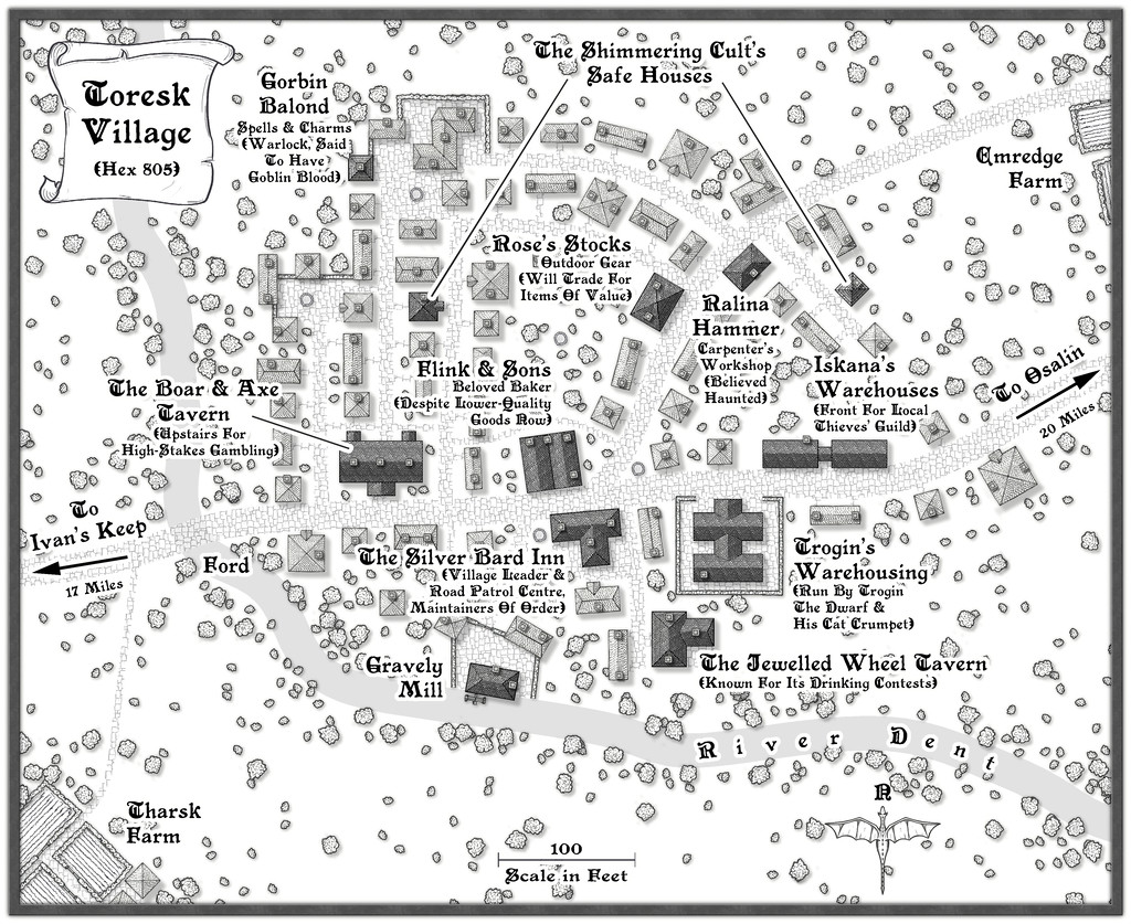
I've updated my WIP topic with this map today too, and there's a higher-res version in my Gallery as well. The FCW and PDF notes follow:


-
[WIP] Community Atlas August Mapping Contest: Cloven House
Although I've already posted about this in the contest topic, to round-off this WIP topic too, here are the final versions of Cloven House, without and with its secret Cellar cave, now with added cupboard under the Cellar stairs:
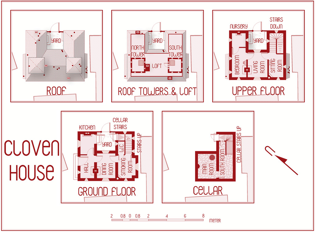
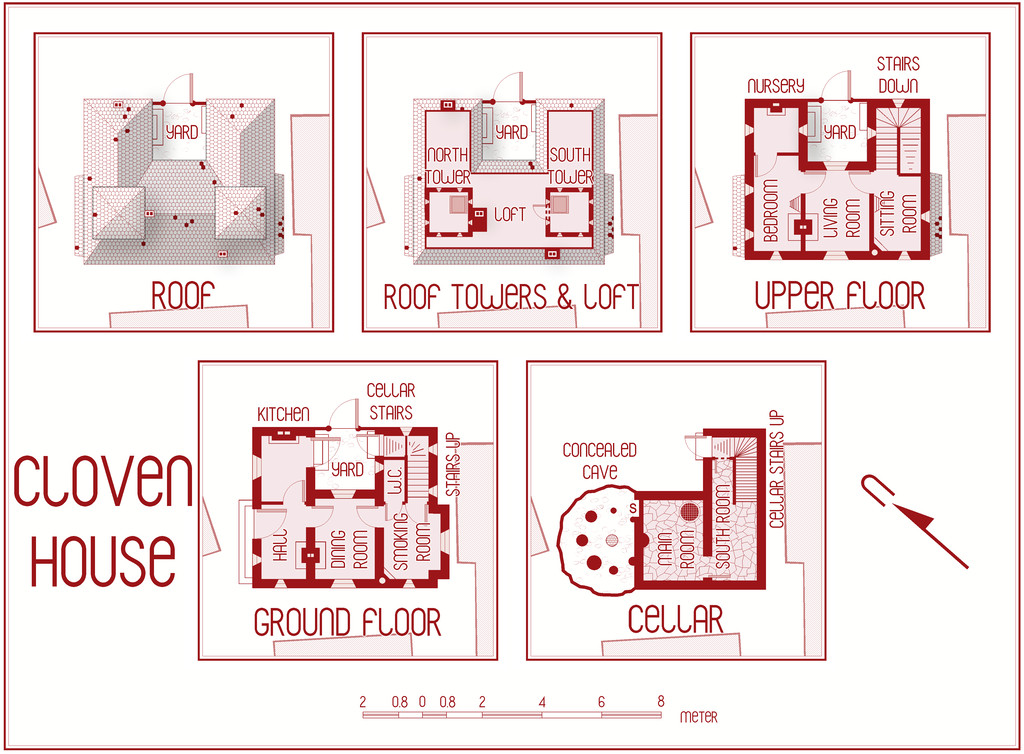
For those who might be interested, and again something that's in the contest entry topic too, I've attached here the PDF notes for the map, which will be in the Atlas version in the fullness of time, for those wanting an early preview of this little haunted house:
Do be aware that there's a hint of "adults only" about a couple of the potential apparitions and other ghoulish elements in these notes. Nothing too salacious, just something to be aware of.
Incidentally, anyone thinking I might have abandoned my preference for random design mechanics in devising my Atlas maps in this instance, might be reassured that there were hints of that in selecting what ghostly items to pick from in constructing this description (I have a long list drawn from numerous past sources and ideas!). Such a mechanism was used less here than in other features I've designed previously, however.
And good luck to all the other contest entrants, especially those struggling to get things finished by the deadline!


-
Developing a map loosely based on Bronze-Age Mesopotamia
As you'll likely be aware already @aulyre, there's a vast and still-growing literature on the archaeo-historical aspects of the region, and you could easily spend years simply wading through as much of that as you'd care to - I have, certainly, starting back in the 1990s!
Of my own maps of this region, I posted a selection just over a year ago on the Forum here. Unfortunately, this was shortly before the Forum underwent a major revamp to its current incarnation, so the post now looks rather a mess, as we had to embed images rather differently then, using an "[Image_12345]" coding notation, but the images are all still there, just no longer where they were meant to be in relation to the text, so you have to hop up and down to get the full gist properly.
As for references, a couple of atlases I found extremely helpful when I was starting out might be of interest, if you haven't come across them yourself as yet, and a couple of texts.
- Michael Roaf's Cultural Atlas of Mesopotamia and the Ancient Near East (published in 1990), which I was thrilled to discover on checking this evening is NOW FREELY AVAILABLE TO DOWNLOAD COMPLETE (!!!), and with a string of appended corrections, thanks to the kind offices of its author, via the Academia website, as of 2017! Link. I think you will need a (free to join) Academia membership to download the full PDF, but that isn't too onerous. For all its date, it is an astonishingly inspirational work in my opinion.
- The Barrington Atlas of the Greek and Roman World edited by Richard Talbert (2000), which unfortunately isn't available online yet, though it is available for iPad as a download (as of 2013). Otherwise, the hardback version is available to purchase alternatively, which I think still comes with an additional CD-ROM, according to some comments I found online (the library copy I borrowed more than a decade ago had one), including this Wikipedia page, although some of the links from that are now broken. GBP prices (brace yourself!) for the hardback start at about 265 GBP (Amazon UK lists), but the iPad version is a less fearsome circa 15 GBP instead (albeit you'll also need an iPad, so swings and roundabouts...). The Princeton University Press pages for these are here: hardback version -- iPad version. The related Ancient World Mapping Centre website is probably worth a visit as well, albeit they've been having major site issues this year, so a number of links don't work currently. Most of their Free Map pages are still functioning, however, and are certainly worth a look too. The Atlas is another astonishing work, if for a somewhat later period than Roaf's text.
- Civilizations of the Ancient Near East edited by Jack Sasson (1995) is a monumental four-volume collection of specialist essays on all manner of topics for the region. The length and quality of individual contributions can be variable at times, but it is a wonderful means to find out at least some basics on a vast array of topics, with follow-up references to help get you started looking for more. Irritatingly, I can't even find an online description or a complete review of it, though I suspect barring extreme good fortune, it will mean accessing a library copy now anyway.
- Ancient Iraq by Georges Roux (1993) is probably THE classic single-volume introductory text to the region and period. It is, incredibly, and despite its date, still currently in print! You can also find it available to borrow or purchase via the Internet Archive here (limited preview version otherwise).
This has taken a lot longer than I'd expected to compile today, so I won't try to say more; there's enough to be going on with already, I suspect in this little lot!
![[Deleted User]](https://secure.gravatar.com/avatar/c75d9a245b74d9c59be0999ea81ca541/?default=https%3A%2F%2Fvanillicon.com%2F92add7f8c954488718110edc4896ad39_200.png&rating=g&size=200)

-
Community Atlas competition entry: The Summer Palace of the Winter Queen
Thanks folks!
@Fersus - Yes, I wondered about a hexagonal grid. However, over the past year, I've been involved in discussions about the use of movement grids in RPGs more generally elsewhere, and the consensus has been almost exclusively for square grids (or occasionally none at all). They're such a feature of most published dungeon maps, it's hard to break away from that, I suspect. Plus because hexes don't scale equally in all dimensions, a square grid works better for estimating distances for the GM by-eye.
Given the whole point about participating in the Atlas, and contests like this too, is to try different things, at least from time to time, my intention was to try to make each of the ten Palace maps different. So for the second one, I picked the Old School Blue style from CA12 (also known as the Create Your Own Style pack). Blue, ice, seemed apt!
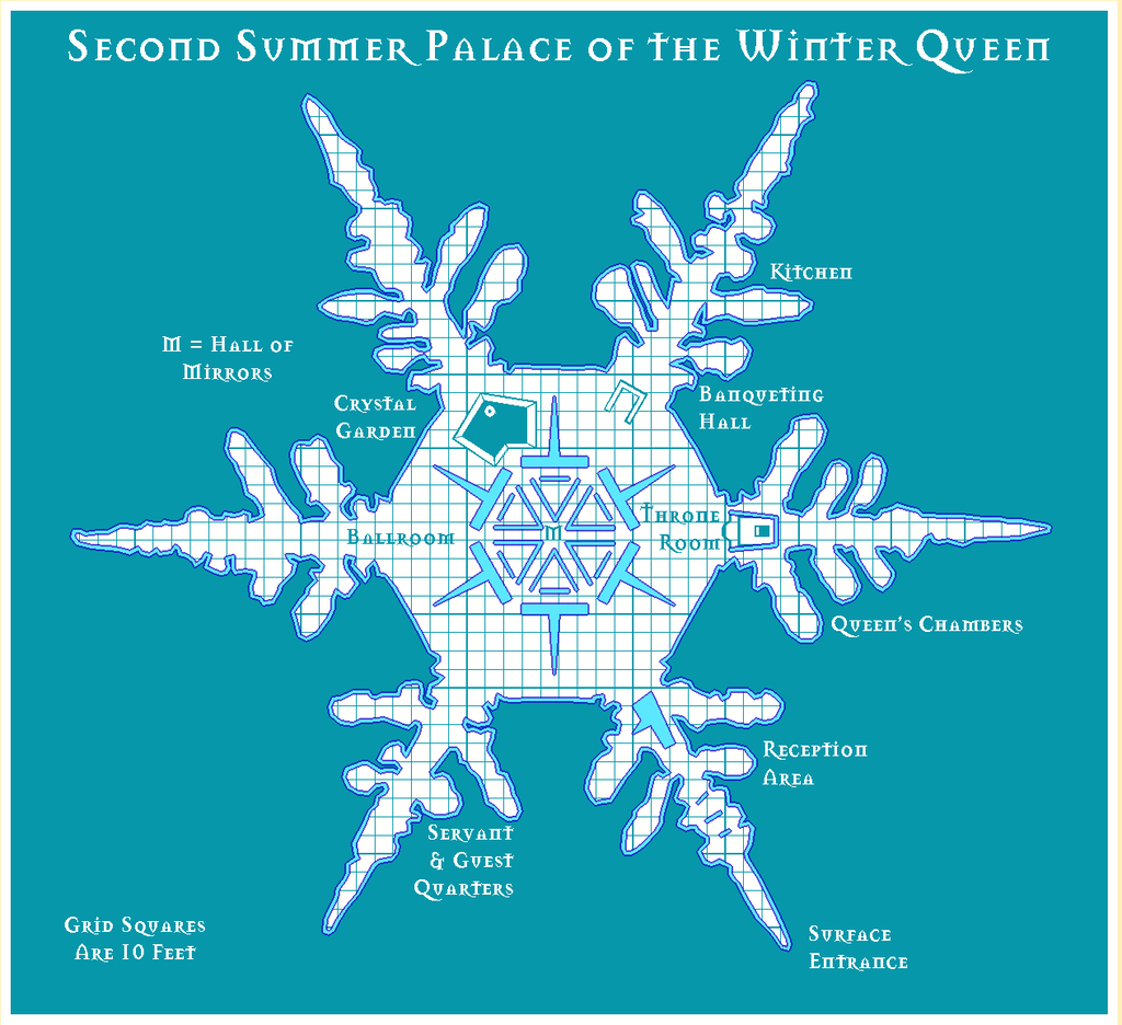
For continuity, I've decided to stick with the Mason Serif Bold font that comes with CC3+, however.


-
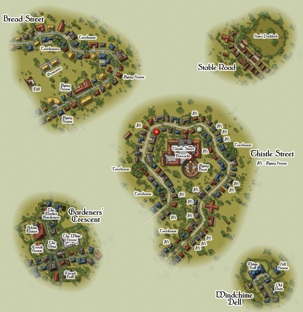
Community Atlas: Embra - Enclosed Places
The final Enclosed Places map condenses the remaining five Places, all streets, into a single drawing:
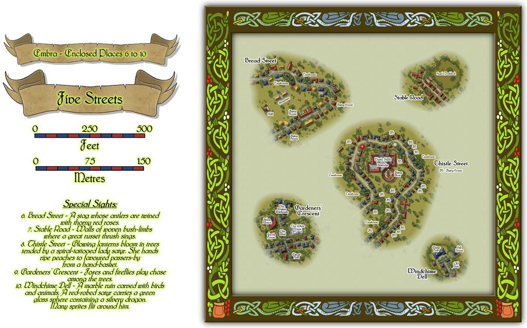
Lots to see here, so let's try a closer view of just the streets:
All the streets had to be designed in a rather different way to the other Places of course, as there were no Judges Guild products that provided plans for such things in isolation. As I noted previously, instead I reworked a set of tables for randomly generating caves and mines from another old Judges Guild text to decide on their lengths, widths, types and layouts, although that system ultimately was more "me" than "JG". Once the base layouts were designed and drawn into the CC3+ map, the streets were redrawn as proper CC3+ streets of the appropriate width and character, and then the CD3 random street options were used to populate them with a range of houses suitable for their overall names and natures.
The streets I came up with were often quite curvy, and the CD3 random street tool isn't too keen on curves and turns, and it can't really cope with junctions at all, so some of the random properties had to be moved, or removed, or adjusted, and sometimes redrawn using a combination of the base shapes that had been generated. Occasionally, some were swapped out for symbols, particularly where I wanted specific or important structures to be. I also decided early on that it wasn't going to be practical to provide interior drawings for all the properties involved - there were simply too many, and that ran the further risk of making them too much alike without a lot of care. I did contemplate doing interiors for selected properties, only to finally decide against that too. So if you need interiors, you'll have to come up with your own for these!
I'll not go into detail here as to what some of the items on these mapped streets are. The PDF and text files in the Atlas should help in that respect. However, it is worth drawing attention to the most significant structure, the Thistle Street Barracks, home to the Knights of the Thistle, Embra's military and police-force, in as much as any Faerie settlement needs such things. These Knights are not entirely my own invention either, as real-world Scottish knights of the realm are known as "Knights of the Thistle" too, though Embra's are naturally of a more magically Faerie kind.
As with all the other individual Places, the idea is these streets can be linked as loosely and in whatever ways GMs may desire to create fresh interpretations of Embra city.
And this is only the first collection of Places in Embra. There are six more such sets still to come!

-
Community Atlas: Map for the Duin Elisyr area, Doriant
So at last, everything's ready, and has now been submitted to the Atlas. This is the final version of the Evth Pass map (higher res version in my Gallery):
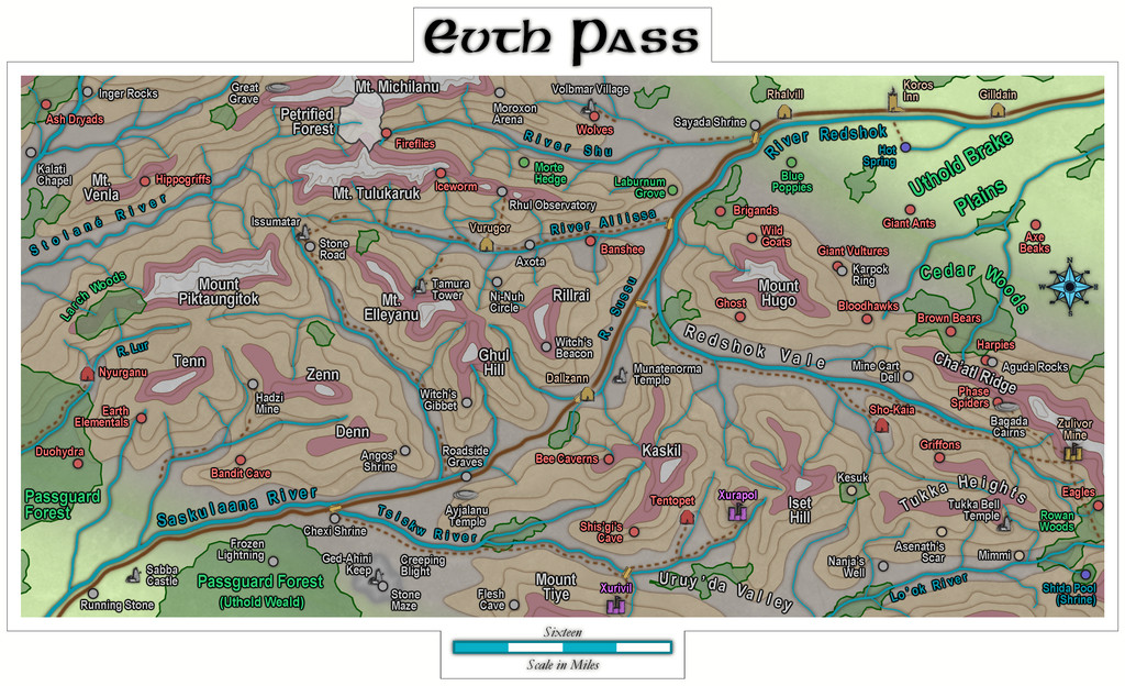
Quite a journey from those three rolled dice that began it all!
Next time, the deities of randomness seem to be dictating a return to Peredur, in its northeastern part, somewhere in the Godtagel area, apparently...

-
Community Atlas: Petroc Hills area, North Central Alarius
The basis behind the Inkwell Ideas setting that I wanted to reuse here was as a sort-of druidic experimental station, a series of caves magically enhanced to allow the growing of normal surface food crops underground, protected from conditions outside, and defended by a group of willingly-summoned elementals. This seemed very suitable for this area, with its short summers and long winters, and although not illustrated specifically on the map, the notes for the area indicate there are a lot of other small caves across the Petroc Hills, which might also be used in future, if the experiment here works. It's all being done in secret for now though, in case something goes wrong, hence the defences. I tweaked a few items, added one or two more, and decided, partly based on the general layout, that it had originally been one of the old Hill Dwarf mines of the district. It's often amazing how much just seems to come together from a couple of initial thoughts in this way. I even contemplated having it be set-up just for growing grain crops for a different flavour of whisky at one point, but decided against that eventually. If they can grow the food underground, that'll leave more field space for cereal crops to make whisky outdoors, after all!
As indicated earlier, I'd be opting for the Jon Roberts Dungeon style from Annual 54 for the mapping of the Caverns, and although I had to make use of a couple of DD3 symbols to round-out what was needed, most of what was required could be found, or repurposed, from that style alone. So to the map:
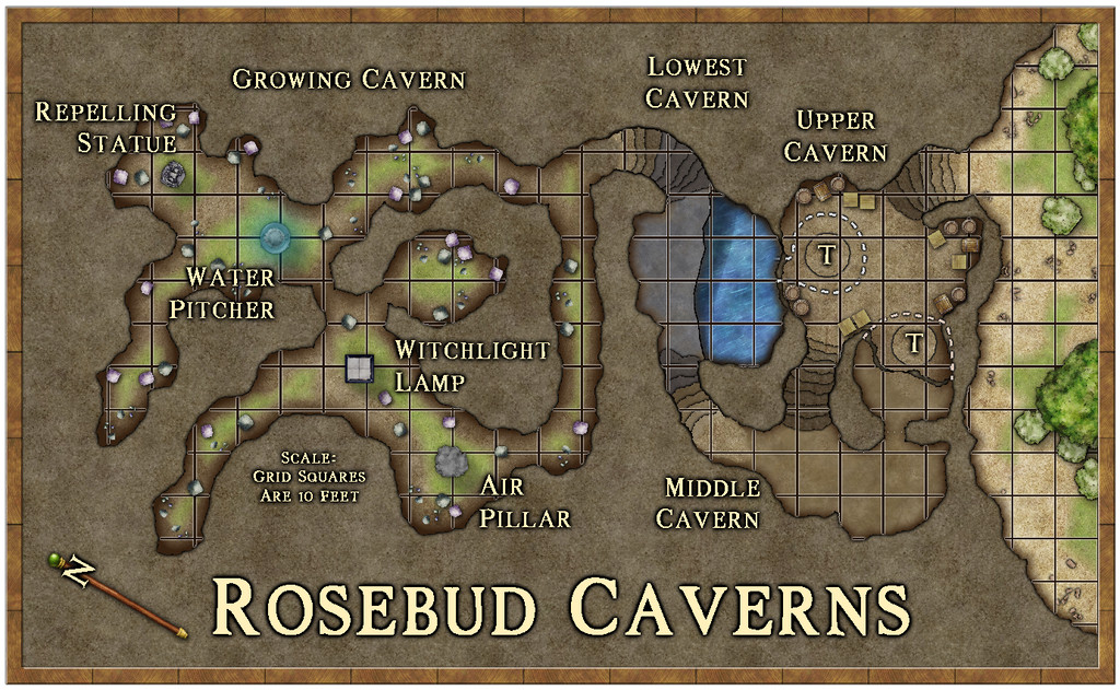
The earthy colouring worked to reinforce the whole "druidic growth" concept, and it's a style that works well in showing what's outside and inside, as having greenery, bushes and trees available. To keep the interior clear enough for GM use though, I decided against adding specific plants there, just some fungi (which are one key aspect of the Growing Cavern area), and also went with a quite strong scaling grid, as distances here can be important. I continued the grid over the water, because half of Lowest Cavern is underwater, and characters could well end up stuck there (the underwater areas including the annexe chamber beneath Upper Cavern - the dashed white lines show bits of the lower caves under Upper Cavern). Those circled "T's" in Upper Cavern are indeed rotating Dwarf-made round trapdoors, dropping down to the barred-cell cave off Middle Cavern, and into the plunge-pool off Lowest Cavern. In Growing Cavern, the four labelled statue-like features are the magical items that keep the place functioning, as explained in the map notes, and which again have vaguely elemental aspects to them.
Probably the biggest mapping challenge was constructing the steps, which did start to feel a little as if they were having to be carved from the native stone by hand for a while! Each has to be on a separate sheet to enable the effects on them to be adjusted to create the illusion of showing which are higher and lower, with the added pain of trying to hide the dark glow at the "back" edge of the top step. They're not perfect, but to my eye at least, they seem perfectly functional to show what they are on the map.
One further troublesome aspect was the abysmally slow redraw times when using the "Trace" command here, because the caves are all drawn as fractal polygons. For reasons I won't pretend to understand, the command insisted on repeatedly following the entire Caverns outline every time it was used, regardless of which way I'd told it to go, or how small an area I was trying to trace. There wasn't any choice though, as aside from needing different floor textures in places, I had to create masks to Color Key cut-out the unneeded segments of the grid, due to the way caves are drawn in this style. Worked in the end, but quick it ain't!
A useful feature of the Inkwell Delver dice set is that one of the six dice is designed to show entrances to the subterranean systems. So for the first time in this mapping project, rather than simply devising a suitable way in to the dungeon or caves separately, the first segment of this map - from the exterior through to that first long, straighter, northeast-southwest passageway in Growing Cavern - came directly from the dice design. We'll get the chance to see another of these entrances in action next time.
As for next time, a new continent beckons, the largest on Nibirum, Doriant, and a location somewhere in the Duin Elisyr region...

-
Community Atlas competition entry: The Summer Palace of the Winter Queen
Thanks Quenten! I started trying to analyse what the influences had been on this set, and while some were obvious enough, the more I thought it over, the more came to mind, mostly from folklore, mythology and fantasy fiction (which latter tends to rely heavily on both the former, of course). Plus as I said back when I started mapping "my" bit of Alarius a couple of years back, I've been working on parts of what was to go into that for decades, and the same is true here too, as essentially another part of the same thing.
Meanwhile, back to Palace 8, which is finally completed. This is it:
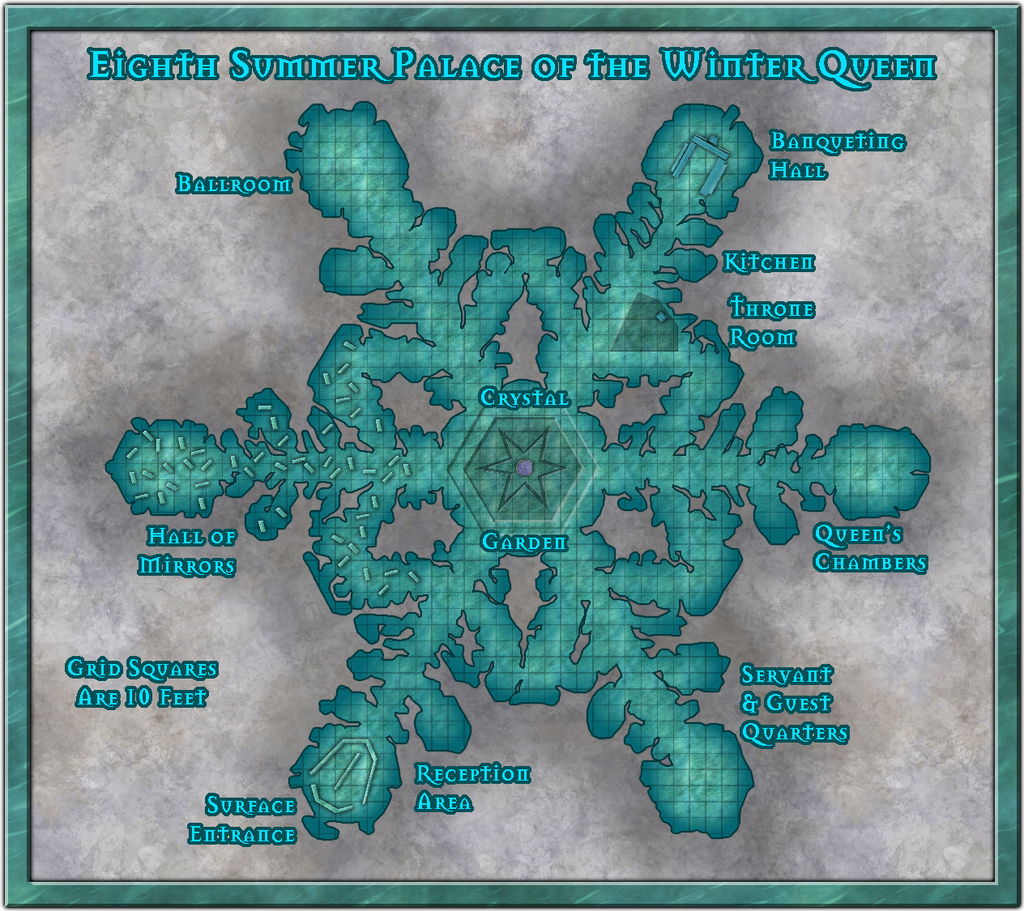
There have been a number of additions and amendments, mostly of a cosmetic nature, beyond the anticipated scattering of symbols and other internal additions, and the labelling, of course. The most substantial change was probably to reduce the overall size of the map somewhat, as the whole felt a little unbalanced at the top and base of the drawing once everything had been added. That was a bit fiddly, because there are always quite a number of entities to amend on the Map Border and Screen Sheets, as well as things like the Background Sheet, whose rectangle was also then too large.
I then had to change the fill for the frame. For all it might be thought a little incongruous as not having a very icy/snowy look, I rather liked the default wood-block pattern on the earlier version, and it looked a serious contender to remain, right up until the point where I adjusted the size of said frame. At which point, the lower border (only) suddenly had a dark horizontal line running right through it, because of the way the fill fits itself into drawings at the scale it had. And that quickly became A Distraction, so sadly it had to go.
The new fill for the frame is Water Green from this CA54 style, scaled-up to prevent it tiling, and holding up remarkably well in doing so, I thought. I was really just experimenting with it, but as soon as it dropped in with the light Bevel Effect, I knew it had to be The One!


-
Dead trees. Spectrum overland [Solved]
It looks like there's a problem with the macro that operates with this drawing tool under Terrain Default, Woods Dead. The first line is:
SYMFILLLOAD @system\fillers\CA163 Snow Woods.symfill
If you change the end of the line to read:
CA163 Dead Woods.symfill
instead, that should solve the problem.
To do this, click on the Overland drop-down menu at the top left of your CC3+ screen, and choose All Map Drawing Tools... That will bring up the Select drawing tool pane. Click the Advanced button at the bottom left of that pane.
Scroll down the Tool name list to find the Terrain Default, Woods Dead tool and click on the name. Just in case you make a mistake at this point (easily done!), click the New button and give the tool a recognisable, but different, name, like "Terrain Default, Woods Dead 2". Click OK.
Now, in your "new" tool, click the Command to execute button. This will bring up the macro that runs with this tool in a separate pane. Change the "Snow Woods" of the first line to read "Dead Woods" instead. Don't change anything else! Click OK.
Then click Save, so the change you just made will work with the tool, and then click OK. You can now draw with the corrected Woods Dead tool. I hope ?
I imagine this will be amended when the second part of the Spectrum Overland set is released in the Cartographer's Annual next month.

-
Paper Modelling (October 2021 Cartographer's Annual)
Thinking further about this, it occurred to me it might be helpful to provide a list of manufacturers that produce, or have produced, downloadable card and paper models, with website links. I'll not pretend this will be fully comprehensive, but it may give some more precise pointers than simply advising people to go and hunt through the OBS sites and CWF. Where not noted, the scale is generally the "standard" 28 mm-32 mm used for most fantasy and science-fiction gaming (which of course isn't a true scale at all, but what can you do?).
Antohammer the Lonely Wargamer: Mostly 2D standee paper minis, with some 2D, 2.5D and occasionally 3D models as well (of terrain features, smaller structures and a few vehicles), fantasy and historical.
Arid Hills Gaming: A limited range of 2D, 2.5D and 3D fantasy and science-fiction gaming terrain and props (e.g. for dungeons and graveyards). Manufacturer has now though switched to 3D printer files only.
Avalon Game Company: Mostly paper minis (plus a massive collection of written RPG accessories, gaming floor tiles, tabletop print-and-play games and accessories), with a limited range of fantasy 2D and 3D scenery, e.g. for dungeons.
Black-Ronin: A small number of 15mm-18mm scale 3D exterior modern buildings and structures, and 2D floorplan textures, intended for historical wargames.
Crooked Staff Publishing: A VAST and increasing range of Pay What You Want texture packs for creating your own scenery. The guy who is the company, Kristian Richards, also produces regular short YouTube videos (59 so far!) on using these to make 2D, 2.5D and 3D models (attaching the texture to various types of card and foamcore first, very often), and has an enthusiastic Discord channel. Although not specific models as such, the PDF file textures could be easily converted and transplanted for personal use in CC3+ to draw specific models using them in Dioramas 3, for instance. The videos are especially to be recommended for new card model builders, and mappers particularly may care to view the, currently 4, "Tiny Terrain" videos, which are in essence 3D hexmaps!
DarekPages: A small, occasionally growing, range of 3D terrain models, some vehicles and 2D minis, for near-future/science-fiction settings (although some items will work for fantasy too), with comprehensive photographic instructions.
Dave Graffam Models: A huge, still growing, range of 3D, mostly exterior-only, models for fantasy and science-fiction settings, with 2D ground tiles as well. Instructions provided with each kit, many of which make heavy use of the PDF layers facility, so each model can be built in a variety of appearances.
Eddnic: All-free, more-or-less unique 3D paper minis, and some 2.5D and 3D fantasy prop models (HeroQuest-style, after the 1980s fantasy boardgame of that name). Not for beginners, as some can be very difficult to make, there are NO instructions, and searching through to find what might be of interest is a challenge in itself (as it's purely a blog site), but the models are often astonishing and - as mentioned - free + unique!
Epic Wargaming also known as Print and Play Fantasy: Primarily wargame-style 2D fantasy standee minis, but there are a couple of 3D models as well, notably a castle on the Wargame Vault site. A major website failure three years back has meant the ranges are still incomplete on the new site, although new minis are produced from time to time. Many of the minis are free, though some are Patreon-only items now.
Fat Dragon Games: A large range of mostly 3D buildings and terrain (for possibly the greatest number of biomes available anywhere in papercrafting), the later models often making use of the PDF layers feature to extend the options for how the final models can appear. Mostly fantasy structures, with some science-fiction, although the natural landscape terrain has many more uses. The owner has switched to 3D printed models only now, so the existing paper-model range is unlikely to expand further.
Finger and Toe Models: A large range of 3D building, structure and vehicle models for fantasy, historical and science-fiction settings. Mostly exterior-only models, and provided with illustrated instructions.
Haunted Dimensions: A host of horror-themed, free, 3D models, games and some minis. The models are chiefly exterior-only, though they do include the Bates and Amityville houses from their respective movies.
Helion & Company: Their Paper Soldiers range of hardcopy and PDF books each contain complete pairs of historical wargame armies of minis, basic rules and usually some 2.5D or 3D terrain features and miniatures, and come with full instructions. Two sets, "European Buildings" and "Castle Assault", are especially heavy on the 3D buildings side!
Hotz Stuff: A range of 1/300 scale historical naval wargame minis, including 3D ship and building/structure models, plus a range of 30 mm (1/60 scale) Wild West buildings and structures. No new items in more than a decade, however.
Kingsway Models: Mostly hardcopy-only OO-scale (roughly 1/76 scale) historical British railway model structures and buildings, with a few free downloadable PDF items. Some 1/43 scale (O gauge) items also available. Print quality on the hardcopy items is often not as good as you would hope, from personal experience, and this is true also of the PDFs.
Lord ZseZse Works: A range of 3D models (as well as lots of 2D ground-tile flats), primarily for fantasy settings, and including some terrain features as well as structures. Also a few 3D vehicles (historical Russian tanks). Unfortunately, after a very successful Elven Papercraft KickStarter campaign in 2014, the company ran into problems delivering all they'd hoped to from that, and although all their models remain available for purchase, no new models are likely, as the owners split-up in 2017.
Mystic Mountain Productions: A modest range of fantasy 3D buildings, mostly exteriors, though some with internal 2D floor plans as well, with comprehensive photographic instructions. Often makes use of PDF layers to enhance the final appearance options. No new models since 2017, however.
Okumarts Games: A large range of mostly 2D standee paper minis, but also produces some 2D, 2.5D and 3D models (dungeons especially in the latter type), mostly for fantasy and science-fiction settings, also some historical minis. Detailed photographic instructions are provided for the models, and the PDFs nearly always make much use of the PDF layers facility.
One Monk (also known as Mayhem in Paper) : Although One Monk produces chiefly 2D standee fantasy minis and a few 3D vehicles, their main website also hosts a huge repository for many free minis and models created over the years by the papercrafting community, in recent years via the Cardboard Warriors Forum's "Monthly Hoard" system, or produced by individuals outside that.
Papercraft Dungeon also known as Kev's Lounge: A range of mostly 2D paper standee fantasy minis, with a small range of 3D structures, the buildings coming with full external and internal artwork. The build mechanics can be complex for the structures, and although photographic instructions are provided, they work better for those with plenty of paper model-making experience. Tending to concentrate chiefly on standee minis only in recent years, however. In addition, not all the models are available via the OneBookShelf sites (the link above), and the owner's site, Papercraft Dungeon, while allowing easy paid-for and free downloads, will only let you download each item in your account a limited number of times - so make plenty of back-up copies!
Papermau: An extensive, very long-running blog, which serves chiefly to highlight some of the many paper model creations freely available across the Internet down the years. The blog's author also makes new, usually 3D exterior-only, models from time to time as well. Being Brazil-based, a few of the blog posts in the past two years have become rather politicised, which may be something to be aware of.
Paper Realms: A large and growing range of 3D exterior buildings, 2.5D/3D subterranean and ruin models for historical and fantasy settings, with some props sets and ground tiles, and some overground 3D terrain models, including options via PDF layers, and instructions.
Papier Schnitzel: A substantial and growing range of mostly historical 3D model structures and ships (Dark Age Europe and Medieval Asia, primarily), usually with full exteriors and interiors, making extensive use of PDF layers, and provided with detailed, photographic instructions.
PERMES: Chiefly a 2D standee minis producer (vast range; historical, fantasy and science-fiction), some of the sets do come with pieces of 2D or 2.5D terrain as well, and a few packs are chiefly of this sort. Instructions are not always provided, so some experience with paper modelling is necessary to get the most from these models.
Ravensblight: The "Toyshop" section has a substantial range of free horror-themed 3D exterior-only buildings, games and vehicles, including full-sized novelty items. Commonly added-to around Hallowe'en in most years, in some cases with RPG/story notes as well, plus separate PDFs with instructions.
Reviresco Tin-Soldier: A small range of mostly exterior 3D model vehicles, structures and buildings, making use of PDF layers to swap things around at times, and with useful, illustrated instructions.
Scalescenes: A growing range of British model railway structures, buildings and some vehicles, available in OO (1/72) and N (1/148) scales and with different exterior texture options (though only one scale, and one texture option, is provided in each paid-for downloadable model). Illustrated instructions come with each kit. Look out too for the free downloadable PDF scale rulers!
Stoelzel's Structures: A large range of highly detailed 3D models with full interiors and exteriors, often with props, and comprehensive instructions, suitable for near-modern and horror settings particularly, with some fantasy items (such as caves and dungeons). PDF layers are not used, so there are commonly huge numbers of pages per PDF, which can make it difficult to keep track of what to print when there are options available. Also relies on the use of foamcore to retain the correct wall thicknesses, so the walls are simply covers for that.
Tinkering Tom: A small selection of 3D building models, fantasy-historical in nature, complete with illustrated instructions.
Wordsworth Model Railway: A substantial range of British OO scale 3D exterior railway model structures and buildings, all free. Also a YouTube channel with a huge number of construction videos. Video 92 is recommended for beginners by the company, as a 10-minute general introduction to making card buildings.
World Works Games: A large range of 3D fantasy, horror and science-fiction model structures, buildings and some vehicles. Unfortunately, the range is no longer supported, so is unlikely to further expand. In addition, the kits are all available only through the company's own website, and it too is not regularly maintained, so in recent years, it has been frequently, and unpredictably, offline for unexplained reasons. As only a limited number of downloads are available from each purchase, be sure to make plenty of extra back-up copies of anything purchased from the site.


