


Monsen
Monsen
About
- Username
- Monsen
- Joined
- Visits
- 660
- Last Active
- Roles
- Administrator
- Points
- 8,858
- Birthday
- May 14, 1976
- Location
- Bergen, Norway
- Website
- https://atlas.monsen.cc
- Real Name
- Remy Monsen
- Rank
- Cartographer
- Badges
- 27
Latest Images


-
WIP tavern
Check this FAQ entry. It contains a pair of video links in addition to the text.


-
Building a world from scratch
Nice work so far.
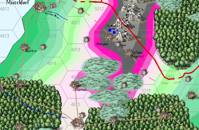
I was looking at your .fcw files, and I noticed that some of the colors around your mountain regions were a very bright pink. I am suspecting this is not intentional and is due to you having an non-default palette installed. If this is the case, I recommend attaching the palette to the drawing so it follows the file instead of having it in your CC3+ data directory as a separate file affecting all maps. You can attach the palette from the :CC2PRESETS: dialog.


-
Scale bar confusion
Most scale bars are 100, but there are exceptions like the style from that thread, where it is 200. Some styles also have multiple lengths, like the Schley overland style which as two at 100 and one at 200
The easiest way to check the scale of it in any style is simply to place it (Make sure the current symbol scale is 1) and measure it using the Info->Distance tool.


-
unsure what I've done to the border
Whenever you have issues like this, it is almost always something on the wrong sheet.
Sometimes the easiest way is to go through the sheets one by one.
If you issue the command
SAUTOHIDEONyou put CC3+ into only displaying one sheet at a time mode. You can then go to the next sheet with theSNEXTcommand or previous one usingSPREVcommand, or to a specified sheet by using theSSET SheetNamecommand.There is a small bug where the sheet indicator in the status bar says Common Sheet even if that is not the active sheet. Issuing a REDRAW command (or Ctrl +R) updates this to show the proper sheet.
Once you have identified what is wrong, which should be obvious when you work through the sheets like that, you can turn normal sheet display back on and show all sheets with
SHOWSHTF *.
-
Guide: Posting Maps & Images
There are several ways you can post your maps to this forum. This post showcases the different options. See the comment below for an example.
Embedding in a post
The easiest way to post a map is to embed an exported image of it into a post. There are multiple ways to do this, you can click the small image icon at the bottom of the post editor to pick a file from your computer, you can drag a file from your computer, or if you have an image on your clipboard, you can even paste it with Ctrl+V. As long as it is an image (.png or .jpg), it will show up inline in your post.

The images are restricted to a maximum of 5 MB in size. Anything larger than that, and an error message will show in the post box. You can close this error message if you want by using the X in the top right corner of it, but it won't be included in your post either way. Uploaded images will be resized to fit in the post (max 1500x1500px), so uploading an image larger that that won't do you any good.
Note that even though images can be up to 5MB, smaller images is much kinder on people having slow or metered connections. I highly recommend that you stick to jpg images over png whenever possible. Jpg is much smaller, and the visual difference is almost non-existent. Jpg is often an issue for people editing the image, but you are usually not posting images for other people to edit anyway, but to showcase your own work.
Attachments
You can also create attachments to your post. Just as with images, you can drag and drop these, or click the attachment clip at the bottom of the post editor to add an attachment. Any files that are dragged into the post editor becomes an attachment if it isn't an image. Note that if you want to upload an image as an attachment instead of displaying inline, you can also use the attachment clip.

As for inline images, attachments are also limited to 5MB in size, and only common file types like text, pdf, office documents, CC3+ maps/templates/symbol catalogs and zip files are allowed.
Note that posting your .fcw files as attachments is a great way for people to take a closer look at your maps, but you should always accompany that with an inline image in the post too, so people can see it right in the forum without opening CC3+. People might not have CC3+ on the computer they are using right then, or they don't have the addon you used so they can't see all the symbols, or they might be on their cell phone or tablet, unable to sue CC3+.
Image Gallery
Every user have their own image gallery where they can upload larger images. You'll find your image gallery by going to your profile page, and then hit the Gallery link in the sidebar. This is also how you visit other people's galleries.
Here you can create your own galleries, and upload images up to 15MB in size to them. As for images in posts, please do consider that a lot of people have slow or metered internet connection, so it might still be worth it to use smaller images if you wish most people to enjoy your gallery, trying to go for the largest image size allowed just to get the best quality may not be the best user experience.
Again, please consider jpg over png. The visual difference is miniscule, and since jpg is so much smaller than png, you can upload an image many times the resolution than you can manage with png, actually giving you a better quality image because of it.
Another way to make the gallery better for people with slower connections is to not have too many images in each album. It takes time to load all the thumbnails when someone enters an album, so it is better to have multiple albums with fewer images than just a few ones with a huge number of images in each.
Linking to a gallery image from a forum post is as easy as to first visit the image in the gallery viewer, copy the url shown in the address bar, and then paste it into a post.


-
Community Atlas 1000th Map Competition - The Winners
A new set of maps integrated. This time I did @Royal Scribe's contest entries, along with some required intermediate overland maps and supporting maps.

-
Creating Symbol Catalog issue.
You can just rename it. The maps doesn't refer back to the .fsc file even if you've inserted symbols from it. As long as you don't rename any of the underlying art (png) files, or the folder/path they're in, you're fine.

-
Suggestions on making a good Symbol for Massive Tall Elven Trees
I have not figured out how to scale them to the same size as Mike Schley's trees, other than by holding Control and just resizing them
Bring up one of the Schely trees for editing from the Symbol Manager, and then use Tools -> Distance to measure the height of it.
Now, edit your own symbol, and just scale it up so the height matches.
Note that your symbols should be edited in the source symbol catalog where you have them, if you edit the symbol from within a map where you have used it, only the copy stored locally in the map will be changed. Also, when you change it in the actual symbol catalog, be aware that maps that already use the original smaller version will continue to use it (because symbol definitions are copied from the catalog into the map on first use) unless you first purge it from the map.


-
Can CC3 export maps’ elements information for other software?
Kind of. The List command in CC3+ gives a lot of detailed information about entities, and it can be exported to a text file that shouldn't bee too hard to parse programmatically.
If that does not cover the need, it is also possible to write your own extension for CC3+ that can walk the entity list and generate whatever output you need, but of course, that does require a bit of programming.

-
New Laptop Time - thoughts on configurations?
One of the reasons it is bad for CC3+ is that a higher resolution monitor simply have more pixels. CC3+ needs to render a new image to present on screen from the vector data every time things change, and rendering a 4K image takes 4 times as much cpu time as rendering a 1080p one. Since it is already working as fast as it can, that basically translates to 4 times as long in actual time as well, so a 4K monitor is simply slower to work on. This will be more or less true for any vector-based application, while raster-based editors works differently, and mostly just need a bit more of memory.
The net effect is offset by the power of your CPU, so the more powerful the CPU, the less of an actual impact a high-res monitor will have.
Windows do have a scaling factor you can apply to your monitor, but this just make it behave like a lower res one, so it is a waste of money, and not all programs work correctly with the scaling (CC3+ works mostly, but there are some issues in some dialogs).
Of course though, all of these considerations are mostly related to the internal monitor of the laptop, since that can't be changed once the machine has been bought.
Having multiple external monitors are always a good thing though. On my fixed setup, I have 4 (+1 (+1)), it really helps productivity.

