


Royal Scribe
Royal Scribe
About
- Username
- Royal Scribe
- Joined
- Visits
- 9,530
- Last Active
- Roles
- Member
- Points
- 3,353
- Birthday
- February 5, 1968
- Location
- San Francisco, California
- Website
- https://legacy.drivethrurpg.com/browse/pub/31814/Royal-Scribe-Imaginarium
- Real Name
- Kevin
- Rank
- Mapmaker
- Badges
- 16
Latest Images


Reactions
-
Atlas Submission: Doriant - Gold Coast - Tyr Alomere
Third floor.
Toggles
PARCHMENT layer to hide/reveal the layer of parchment that provides a sort of sepia filter over the outdoor areas.
TEXT LABELS (NUMBERS) layer to hide/display the numbered labels.
TEXT LABELS layer to hide/display the legends describing the labeled numbers.
Files
Description
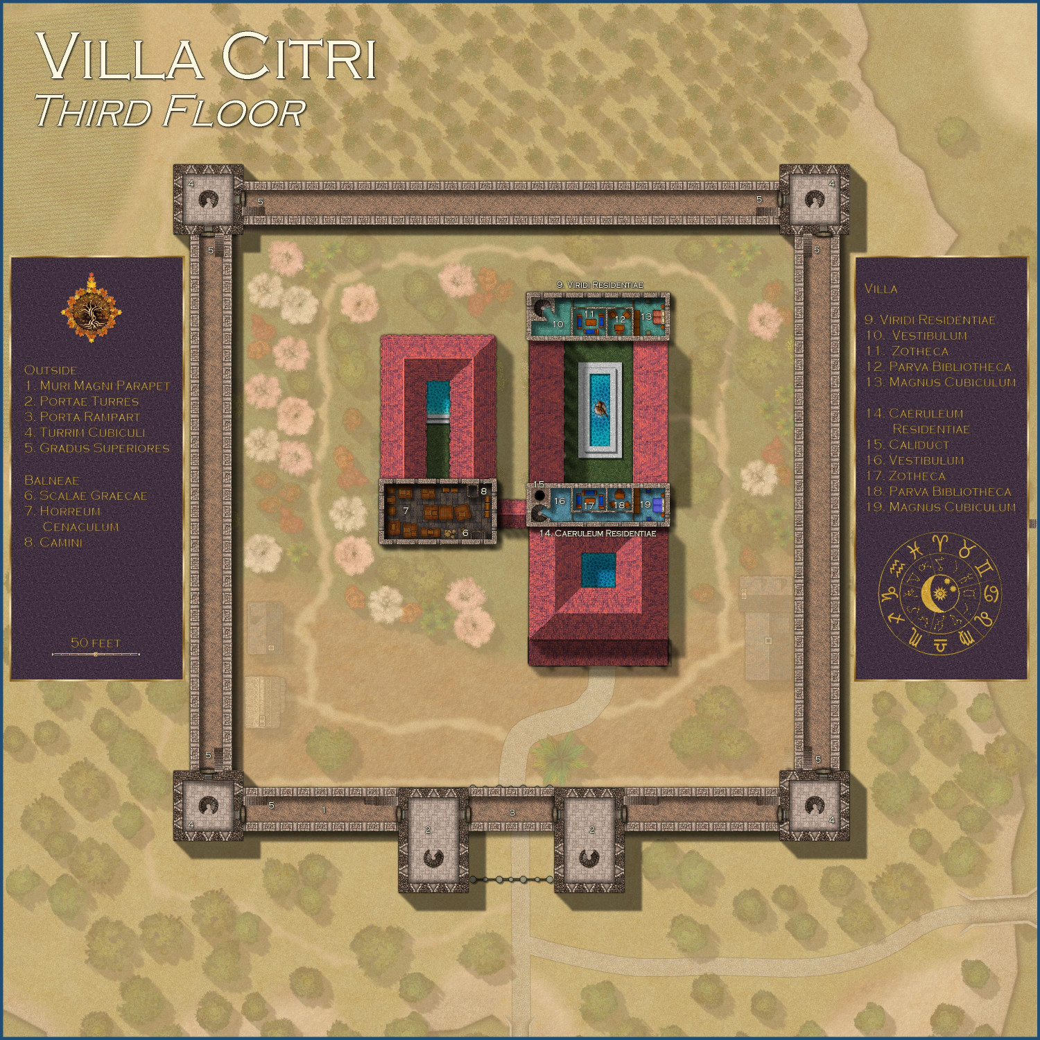
The third story of the Villa Citri and its estate.
Outside
1. Muri Magni Parapet
The open-to-the-sky crenellated rooftop walkway of the Great Walls can be accessed through arched doorways from the corner and gatehouse towers. Metal doors protect the towers from intruders. Stairs ascend to the rooftops of the corner and gatehouse towers.
2. Portae Turres
The upper stories of the gatehouse towers have spiral staircases descending to the second floor, and arched doorways providing access to the parapet. It also provides access to the Porta Rampart, a parapet over the gates.
3. Porta Rampart
A parapet over the gates from which guards can address visitors to the villa.
4. Turrim Cubiculi
The chamber at the top of the corner towers. Each has a staircase that descends to the second floor and arched doorways that provide access to the Great Wall’s parapets.
5. Gradus Superiores
Staircases that ascend from the crenellated parapets to the rooftops of corner and gatehouse towers.
Balneae
6. Scalae Graecae
Walled staircase that descends to the second floor.
7. Horreum Cenaculum
An attic used primarily for storage.
8. Camini
The chimney venting smoke from the hypocaust’s furnace.
Villa
9. Viridi Residentiae
The “Green Apartments,” so named for the color of the tiled floor, is one of the two luxury suites. In prior generations, the Lord and Lady of the villa sometimes maintained separate residences. This suite is currently used by the Earl of Westford when he visits his mother.
10. Viridis Vestibulum
An outer reception area for the Green Apartments.
11. Viridis Zotheca
A private lounge and dining area for the Green Apartments.
12. Viridis Bibliotheca
An office and small library.
13. Magnus Cubiculum
The main bedroom for the Green Apartments.
14. Caeruleum Residentiae
The “Blue Apartments” are named for the blue tiles on the floor. Unlike the Viridi Residentiae, the floors here are heated. The Dowager Countess of Westford occupies this suite as her own residence.
15. Caliduct
Hot air from the hypocausts vents from here to heat the floors of the apartment,
16. Caeruleum Vestibulum
An outer reception room for the Blue Apartments.
17. Caeruleum Zotheca
A private lounge and dining area for the Blue Apartments.
18. Caeruleum Bibliotheca
An office and small library.
19. Magnus Cubiculum
The main bedroom for the Blue Apartments.
Toggles
PARCHMENT layer to hide/reveal the layer of parchment that provides a sort of sepia filter over the outdoor areas.
TEXT LABELS (NUMBERS) layer to hide/display the numbered labels.
TEXT LABELS layer to hide/display the legends describing the labeled numbers.

-
Atlas Submission: Doriant - Gold Coast - Tyr Alomere
Here's the second floor.
Toggles
PARCHMENT layer to hide/reveal the layer of parchment that provides a sort of sepia filter over the outdoor areas.
TEXT LABELS (NUMBERS) layer to hide/display the numbered labels.
TEXT LABELS layer to hide/display the legends describing the labeled numbers.
Files
Description
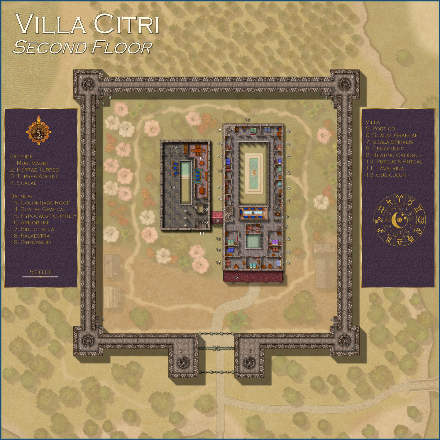
The second story of the Villa Citri and its estate.
Outside
1. Muri Magni
On this level, the great outer walls of the estate have a ten-foot-wide central corridor that allows for defenders to be protected while shooting arrows through arrow slits.
2. Portae Turres
The second story of the gatehouse towers includes a spiral staircase that extended from the first floor all the way through to the third floor. Arrow slits allow for defending the main entrance to the villa’s estate.
3. Turres Anguli
The corner towers can be accessed from the ground floor via external staircases. Each has a spiral staircase leading to the third floor.
4. Scalae
These external staircases, unwalled on one side, provide access from the outside grounds to the second stories of the corner towers.
Villa
5. Portico Roof
Windows from the second story provide a view of the roof of the covered portico, or front porch.
6. Scalae Graecae
Staircase enclosed by walls on both sides.
7. Scala Spiralis
Spiral staircases that provide access to the third story.
8. Cenaculum
The private upstairs dining room on an upper floor of Roman houses.
9. Heating Caliduct
Hot air from the hypocaust is piped through here to heat the second story floors.
10. Puteus & Puteal
A chamber (puteal) that houses a wellhead inside the villa. Water is piped in to the well from the river.
11. Lavatrina
On this floor, the lavatories do not have a direct connection to the sewers. Instead, each has a cabinet over a chamber pot that is periodically emptied and clean by the villa’s servants.
12. Cubiculum
The guest bedrooms on this floor are a bit nicer than the ones below.
Balneae
13. Colonnade Roof
As the colonnade is only one story high, the views here provide a glimpse of its roof.
14. Scalae Graecae
Walled stairs connects this floor to both the first and third floors of the bathhouse.
15. Hypocaust Chimney
Brings the smoke from the hypocaust’s furnace to be vented to the outside.
16. Armorium
A closet.
17. Bibliotheca
The villa’s main library has a vast collection of books and scrolls, as well as several seating areas, including a lounge overlooking the tepidarium.
18. Palaestra
This exercise area includes a promenade overlooking the tepidarium.
19. Gymnasium
This room includes exercise equipment for use here or in the palaestra.
-
Atlas Submission: Doriant - Gold Coast - Tyr Alomere
Here's the first floor:
Toggles
PARCHMENT layer to hide/reveal the layer of parchment that provides a sort of sepia filter over the outdoor areas.
TEXT LABELS (NUMBERS) layer to hide/display the numbered labels.
TEXT LABELS layer to hide/display the legends describing the labeled numbers.
Files
Description
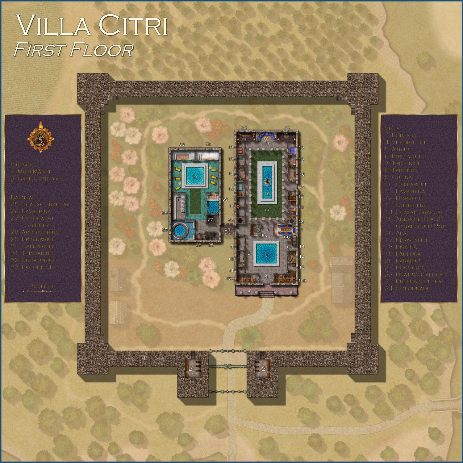
The ground level of the Villa Citri and its estate.
Outside
1. Muri Magni
At the ground level, the great walls that surround the estate are solid stonework, as are this section of the corner towers.
2. Portae Turres Controls
Each of the gatehouse towers has a chamber access by a short flight of stairs that house the controls for the gate and the portcullises. Both sets of controls can operate the gates independently of the other. Solid metal doors guard the entrance to these chambers, and metal gates at the top of the stairs also provide further protection. A spiral staircase in each ascends to an upper story of the gatehouse.
Villa
3. Portico
This covered porch of red marble has four column pillars supporting the roof, as well as a railing of black marble.
4. Vestibulum
The entryway leads to the atrium, where guests may be greeted by their host.
5. Atrium
Guests are received by their host in this central area. Though the walkways are covered by the floors of the second story, sunlight from an opening in the roof (called the Compluvium) over the central pool keeps the room well-lit during the day.
6. Impluvium
The pool in the center of the atrium, called the impluvium, is positioned beneath an opening in the ceiling, called the compluvium. Rainwater collects in the pool and is then piped to a cistern used in the kitchen.
7. Triclinium
The villa’s main dining room has couches arranged in a U-shape, with a short table for food in the center of them.
8. Tablinum
The open office is used by the proprietors of the villa to conduct business with guests while keeping an eye on both courtyards. An enclosed chamber (8A) allows for more private work.
9. Culina
The villa’s kitchen includes a well with water piped in from the impluvium, though this villa supplements it with additional water piped in from the river. The wood-burning stove vents directly to the outside.
10. Cellarium
The pantry for the kitchen can only be accessed from the kitchen.
11. Lavatrina
The lavatories on this level all have shafts where waste is deposited directly into the sewers.
12. Horreum
These rooms are used for storage.
13. Cubiculum
On this level, there are six cubiculae, or bedrooms, surrounding the peristylium courtyard. On this level, the bedrooms are mostly used by guests.
14. Scalae Graecae
A staircase enclosed by walls provides access to the second story. An archway also provides access to stairs that lead to the basement.
15. Andron & Gynaeceum
In ancient times, the Andron (#15a) was used exclusively by the men of the household for libations and conversation, while the Gynaeceum was used by the household’s women. Both are now used as front parlors for socializing.
16. Alae
These two chambers flanking the courtyard are used to honor the family’s ancestors.
17. Peristylium
This courtyard, which is also open to the sky, has a central fountain, with column pillars surrounding the courtyard.
18. Piscina
The central fountain beneath an opening in the roof collects rainwater, but water from the river is also piped in to keep the fountain operational in dry months.
19. Exhedra
This semicircular seating area is used for socializing. A brazier enchanted with a Continual Flame spell allows for heatless, smokeless flames to provide lighting in the evenings. A second enchantment allows for heat to radiate from it when desired on colder evenings.
20. Lararium
The chambers flaking the exhedra are shrines for the household’s favored gods. The braziers here, like that in the exhedra, are enchanted with a Continual Flame spell.
21. Posticum
The rear exit is used by the villa’s servants, as well as by the villa’s residents and guests when they wish to avoid the front entrance.
22. Heating Caliduct
This pipe brings hot air from the hypocaust in the basement to warm the villa’s upper stories.
23. Puteus & Puteal
A chamber (puteal) that houses a wellhead inside the villa. Water is piped in to the well from the river.
24. Colonnade
A covered walkway surrounded by columns instead of walls connect the villa to the balneae, the bathhouse.
Balneae
25. Scalae Graecae
Walled stairs ascend to the bathhouse’s second floor and descend to the basement.
26. Lavatrina
Lavatories with shafts that descend directly to the sewers.
27. Hypocaust Chimney
Connects to the hypocaust in the basement which is used to heat both the bathhouse and the villa, and to provide for hot water.
28. Apodyterium
A changing room for those using the balneae’s amenities, as well as to wash up before using the communal pools.
29. Frigidarium
A cold-water pool that provides for an invigorating plunge before being warmed up in the bathhouse’s warmer pools. The hypocaust does not extend below this room, so it is kept chilled even as the rest of the bathhouse is kept warm.
30. Caldarium
A hot-water pool located directly above the hypocaust’s furnaces keep the water as warm as any bath.
31. Tepidarium
The water in this pool is piped in from both hot- and cold-water cisterns, keeping the water at a comfortable and refreshing temperature. Though this area is open to the sky, at least over part of the pool, the tiled floor is heated by the hypocaust.
32. Sudatorium
A steam sauna, with hot water from the hypocaust poured over heated rocks to provide for steam.
33. Laconicum
A dry sauna heated from the hypocaust in the basement below.
-
Atlas Submission: Doriant - Gold Coast - Tyr Alomere
I am ready to submit the maps for the Villa Citri in the town of Tyr Alomere. I will do each map as a separate post in this thread, starting with the main outdoor map.
Toggles
TEXT LABELS (NUMBERS) layer to hide/display the numbered labels.
TEXT LABELS layer to hide/display the legends describing the labeled numbers.
Files
Description
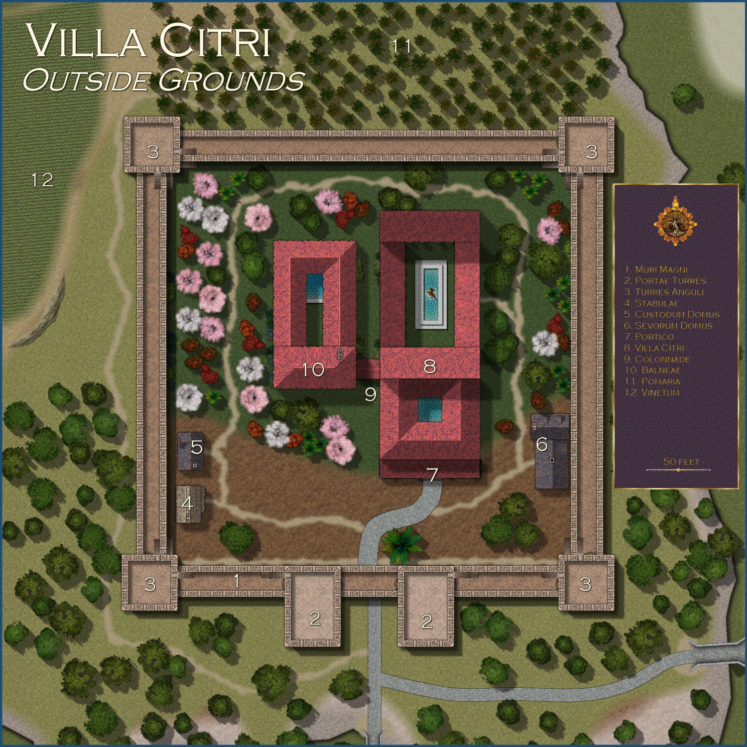
In the village of Tyr Alomere, the Earls of Westford have owned the Villa Citri for generations. The villa is known for its orchards of orange trees as well as its vineyards of wine grapes.
It has at times served as a summer vacation home for the noble family, but at the present is the regular residence of Lady Amfiri Prelcort, Dowager Countess of Westford, widow of the seventh Earl of Westford and mother of the eighth. She lives there with a few close friends, attended by faithful servants and guards, where she receives a steady stream of family visitors and other guests.
The villa’s grounds includes a detached bathhouse, or ballneae, as well as detached quarters for servants and for the guards, along with a barn.
Outside Areas
1. Muri Magni
The great outer wall, called the Muri Magni, is 20 feet thick (with crenellations that extend a bit beyond the edge of the wall), with the parapet rising 25 feet above the ground.
2. Portae Turres
The gatehouse towers extend 15 feet above the parapet. They have ground-floor entrances on the inside of the fortified wall. The gates themselves include an outer portcullis, a metal gate that is generally left open, and an inner portcullis. Each gatehouse has control mechanisms that allow for independently opening or closing the gates, and for raising or lowering the portcullises.
3. Turres Anguli
The corner towers of the fortified wall extend ten feet above the great wall’s parapets. They can be accessed through external stairs that climb fifteen feet to the second story.
4. Stabulae
The stables are sufficiently large to house the Dowager Countess’ horses as well as those of any visitors.
5. Custodum Domus
The residence of the estate’s guards.
6. Sevorum Domus
The residence of the estate’s servants.
7. Portico
The villa’s covered porch, supporting by four columns, two on either side of the stairs.
8. Villa Citri
The villa is three stories above ground.
9. Colonnade
The covered walkway connecting the villa to the balneae is lined with column pillars but has no walls.
10. Balneae
The villa’s bathhouse is used by residents and guests as well as by the villa’s staff (at separate times) for personal hygiene, exercise, and recreation.
11. Pomaria
The orchard has an abundance of orange trees.
12. Vinetum
The vineyard where the estate grows grapes that are then fermented into wine.
-
Atlas Submission: Doriant - Gold Coast - Tyr Alomere
I realized in the middle of the night that I forgot something -- the cutout in the parchment that allowed the courtyards to be shown without the parchment filter. There should be another toggle for the Floor 2 and Floor 3 files, second and third floors: the COURTYARD layer. Hiding it hides the magenta polygon, causing the courtyards to be hidden behind the gauzy parchment.
Or if you think that will just be too confusing, here are some FCW files that delete the magenta polygons, so the courtyards are always included when the outside areas are grayed out.
-
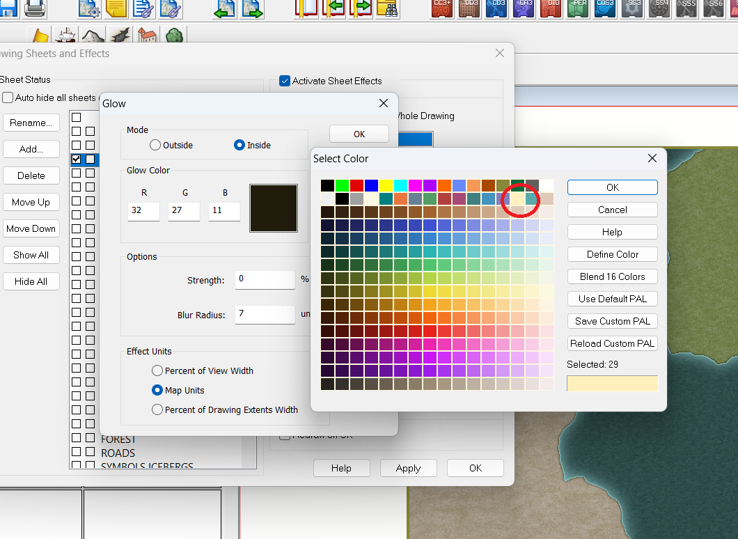
Issue with beach on Spectrum Overland
Just to elaborate on what Ricko said: on the LAND sheet, you'll see three GLOW effects. If you click on the first one and click Edit, you'll see that it's an inside glow with a dark color. (The other two Glow effects are outer glows that add the light blue to the coastal waters.) If you click on the color in the Glow parameters, you can change the color. Ricko is recommending the tan color I circled on the screengrab.

-
Drawing lakes over forests and mountains sheets with 2023 MonkeyFrog Overland style
One other thing to note: the cutout will cut through terrain, but it won't cut through symbols like the tree symbols that surround your forest.
-
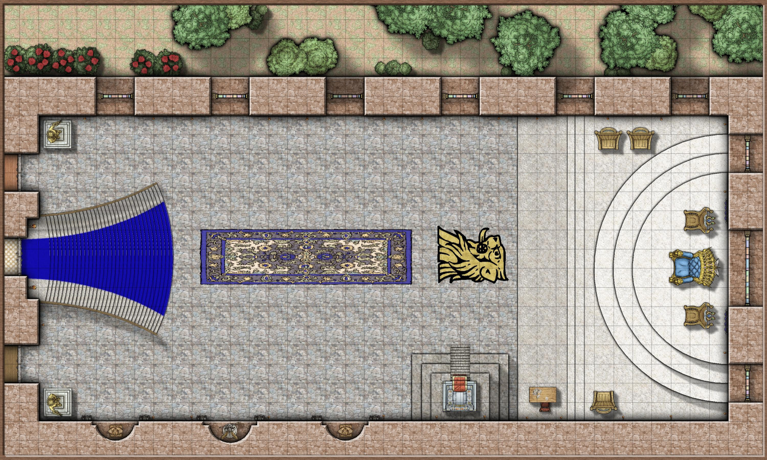
[WIP] - An audience with the King
Either the upper throne chair is to close, or the lower one is to far from the main throne. Like 1/4 of a grid.
I'll tweak it. Wasn't sure if I should aim for precision, or intentionally leave it imperfect. Sounds like it's more of a distraction.
-
[WIP] - An audience with the King
Made some tweaks (including expanding the entry landing), and then created the feast.
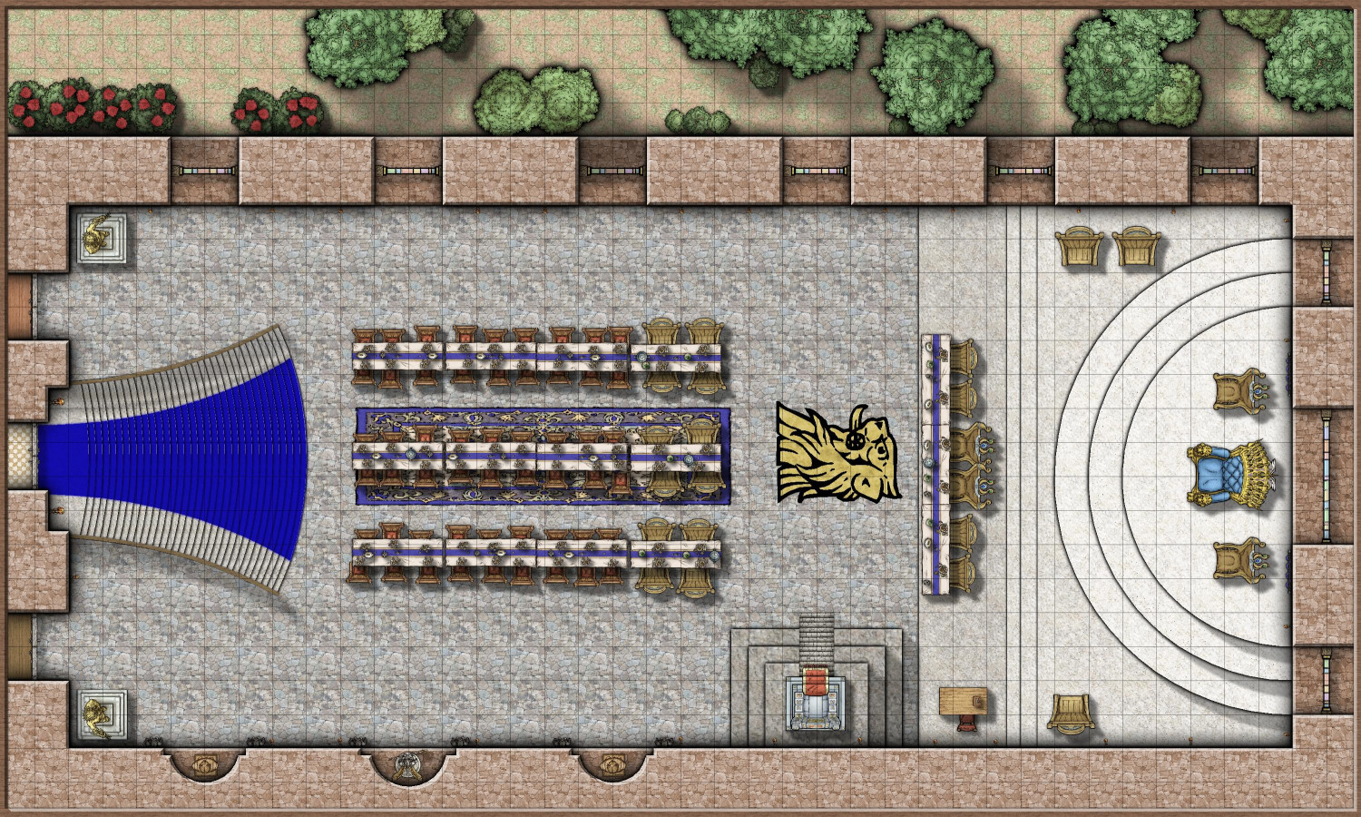
Working on the third map now...
-
City of Serbinel
Love how the structure symbols work together to make a city. These styles work really well together.

