


Royal Scribe
Royal Scribe
About
- Username
- Royal Scribe
- Joined
- Visits
- 9,534
- Last Active
- Roles
- Member
- Points
- 3,353
- Birthday
- February 5, 1968
- Location
- San Francisco, California
- Website
- https://legacy.drivethrurpg.com/browse/pub/31814/Royal-Scribe-Imaginarium
- Real Name
- Kevin
- Rank
- Mapmaker
- Badges
- 16
Latest Images


Reactions
-
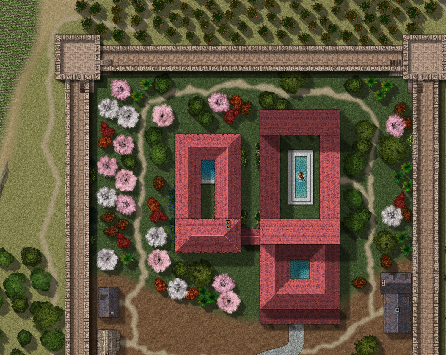
[WIP] Villa Citri (Roman-style villa)
I think that front and back parts of the northern courtyard are supposed to be a whole story above the east and west sides, but in looking closer at my sheets, I didn't draw them that way. (I used too many images for inspiration that had different floor plans, and I think I muddled them up.)
I moved those two roofs to higher sheets. Does that capture it a little better?

-
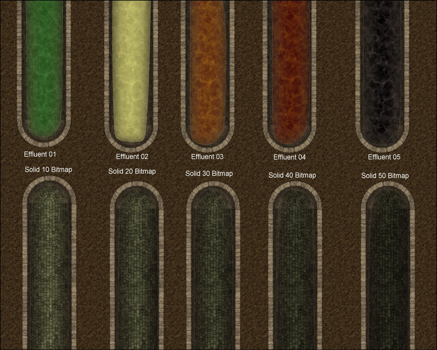
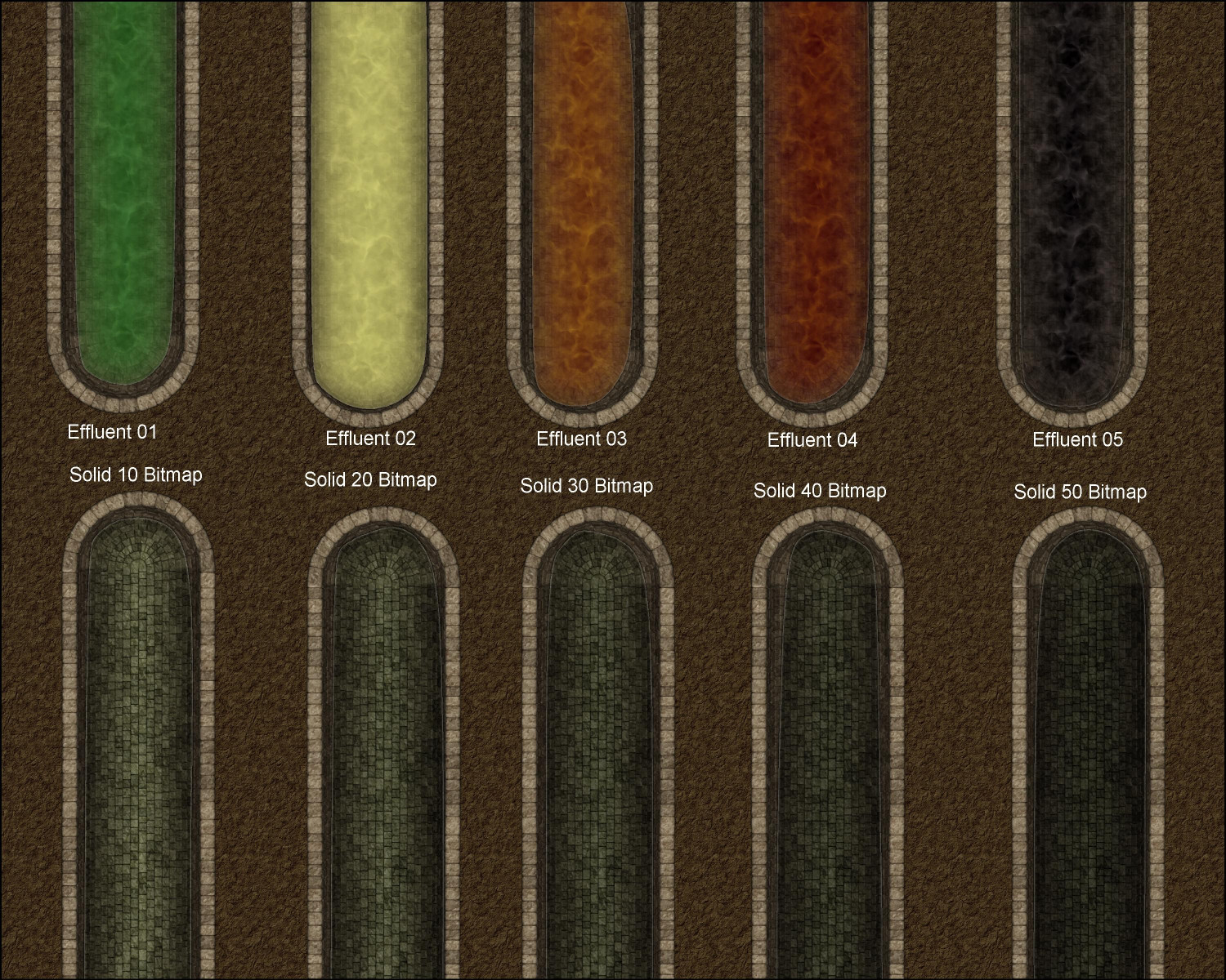
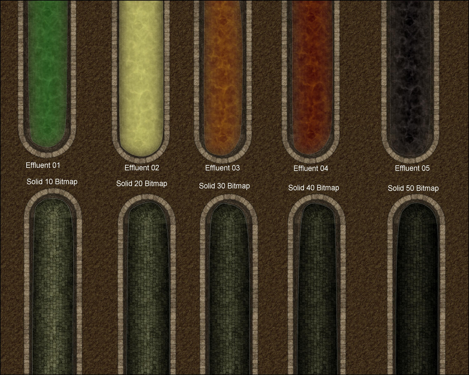
[WIP] Playing around with Sinister Sewers
On today's Live demo, which was about Sinister Sewers, I asked for recommendations for what to use as a fill style for pure water uncontaminated with sewage (such as water runoff from storm drains). I had been using Effluent 05, but on another Water sheet with a transparency effect. Sue recommended trying one of the Bitmap Solid fill styles.
Here's a practice attempt, with the five effluent fills above and then five on the solid bitmaps below (from Solid 10 Bitmap through Solid 50). The five below are on a Water 2 sheet in case anyone recommends effects different than the regular Water sheet. Right now, I put the same effects on Water 2.
I am leaning towards Solid 40 Bitmap for storm drain runoff (since that water will have dirt and other impurities), and maybe something like Solid 20 Bitmap for pure water (for example, if dwarves are using this technology for a subterranean aqueduct).
Thoughts? (If this is too difficult to see here, I can post it in my Gallery if that has a better resolution.)

-
[WIP] Playing around with Sinister Sewers
Hmmm, I'm not seeing much of a difference, but there's some glare on my screen at the moment. Here they are:
First Edge Fade off, second one on
First Edge Fade on, second one off

Both Edge Fades off
And here's the FCW file:
-
MY MUNDI IS READY!
These are great. I really like how you scaled up the dunes in the Mamede map. It's giving me Lawrence of Arabia vibes!

-
Tutorial - Between hills, rivers and trees
Yes, thank you! I've seen the first one before but it's handy to have the tutorials all in one thread. Much appreciated!
-
floathing Island and Babel Tower style city
Very cool!

-
[WIP] Community Atlas, 1,000 Maps Contest: Villages in The Whispering Wastes of Haddmark, Peredur
if they serve as meeting place for the populace in the evenings, even 3 places isn't necessarily that extravagant for a population of say 300
That's a good point. With my villages, I've tried to keep in mind how and where the locals would socialize. Taverns and inns are also good places to catch a performance of a wandering bard or troubadour, or a troupe of actors.
Also, a small village might still get a lot of travelers passing through if it's on an important trade route, or along a route for a pilgrimage to a holy shrine. Or the last stop for adventurers trying their luck searching for treasure in the ruins of an ancient temple (or their first stop on the way home). My village has a winery, and I figured that merchants buying wine at the winery to resell in other towns and cities would want a place to spend the night before heading back with with their casks of wine.

-
Style Suggestions for Annuals
Looka like we posted threads concurrently! Your Mesoamerican overland and dungeon requests would work well with my Jungle Adventurers suggestion. I would love Greco-Roman stuff. And I’ve been musing on designing a haunted house for Halloween, so your 1920s Horror House idea works wirh that. I love all of your suggestions but those were the ones I wanted to second.

-
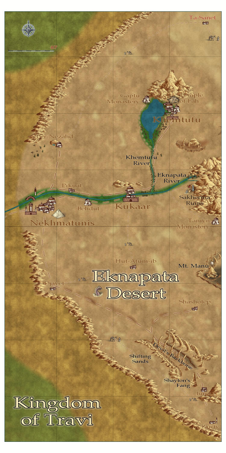
[WIP] Community Atlas - Eknapata Desert
Thank you! Here's how it looks with the effects changes. And I've standardized the font sizes to three: 10 points for country names, 5 points for the three major cities, and 3.5 pts for everything else.
-
Chotlan - Meso American little town
Love the use of magic on the temple and the flames at the arena
