


Royal Scribe
Royal Scribe
About
- Username
- Royal Scribe
- Joined
- Visits
- 9,537
- Last Active
- Roles
- Member
- Points
- 3,353
- Birthday
- February 5, 1968
- Location
- San Francisco, California
- Website
- https://legacy.drivethrurpg.com/browse/pub/31814/Royal-Scribe-Imaginarium
- Real Name
- Kevin
- Rank
- Mapmaker
- Badges
- 16
Latest Images


Reactions
-
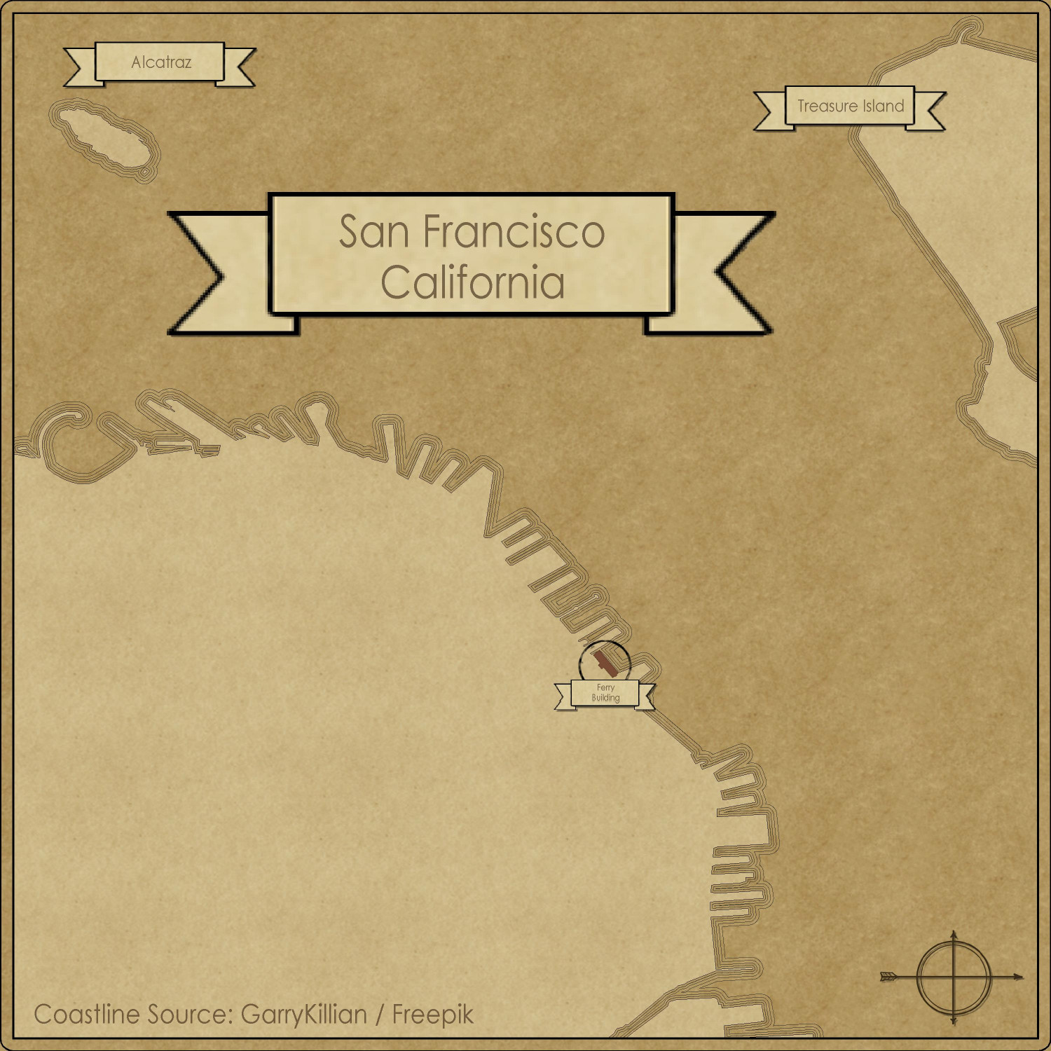
[WIP] San Francisco, California (Parchment Cities)
Ever since the Parchment Cities annual came out in February, I've been wanting to create a map of old San Francisco, California -- the city where I live and was born, and where generations of my ancestors were from.
I wanted to find a reference map for 1895, because by that point, six of my eight grandparents were living here by then. (Two moved here no later than the late 1860s, one moved here in 1884, two others moved from different parts of France in the early 1890s, meeting and marrying in San Francisco.) Unfortunately, the images I found were poor-quality JPGs that would have been a challenge to draw the coastline correctly. (The coastline changed significantly after the famous earthquake in 1906 that burned a huge swath of the City. In rebuilding the City, a lot of the rubble was tossed into the bay, changing the coastline and becoming landfill that newer buildings were built on top of.
Once I made peace with not finding a good 19th century source map, it become much easier to hunt down good quality SVG images on Wikimedia Commons that I could convert into a DXF file with CloudConvert. That made doing the coastline much easier.
I will still have to do the streets and blocks using JPG reference images, as my source map included elevation changes rather than streets. To make it a little easier, I decided to focus on the northeast corner of the city, the downtown Financial District. I thought about doing my own neighborhood but it's in the middle of the City, three miles to the east of the ocean, and three miles southwest from the bay, so I wouldn't have gotten any of the lovely coastline.
Anyway, here's what I have so far. The streets will take a lot more time.


-
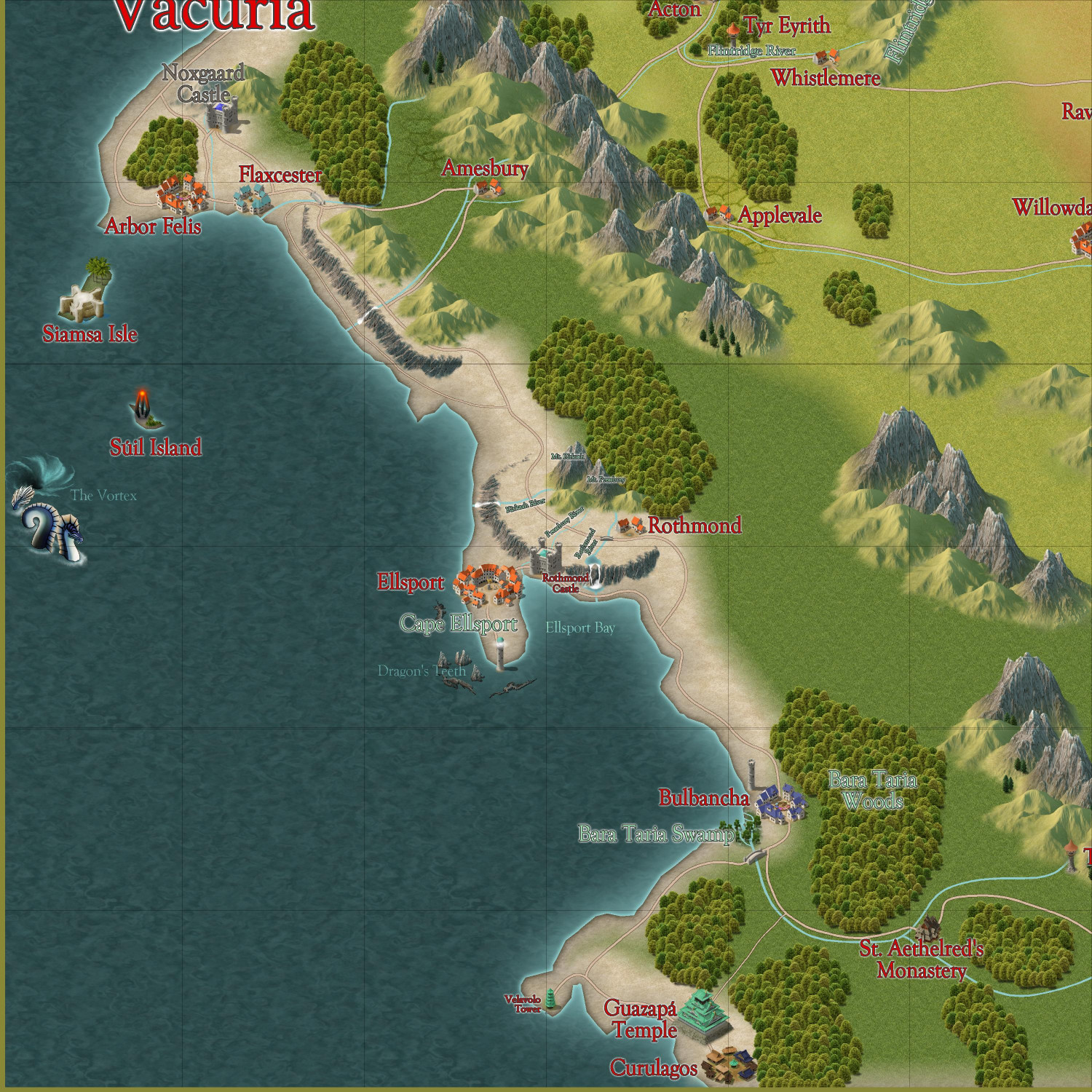
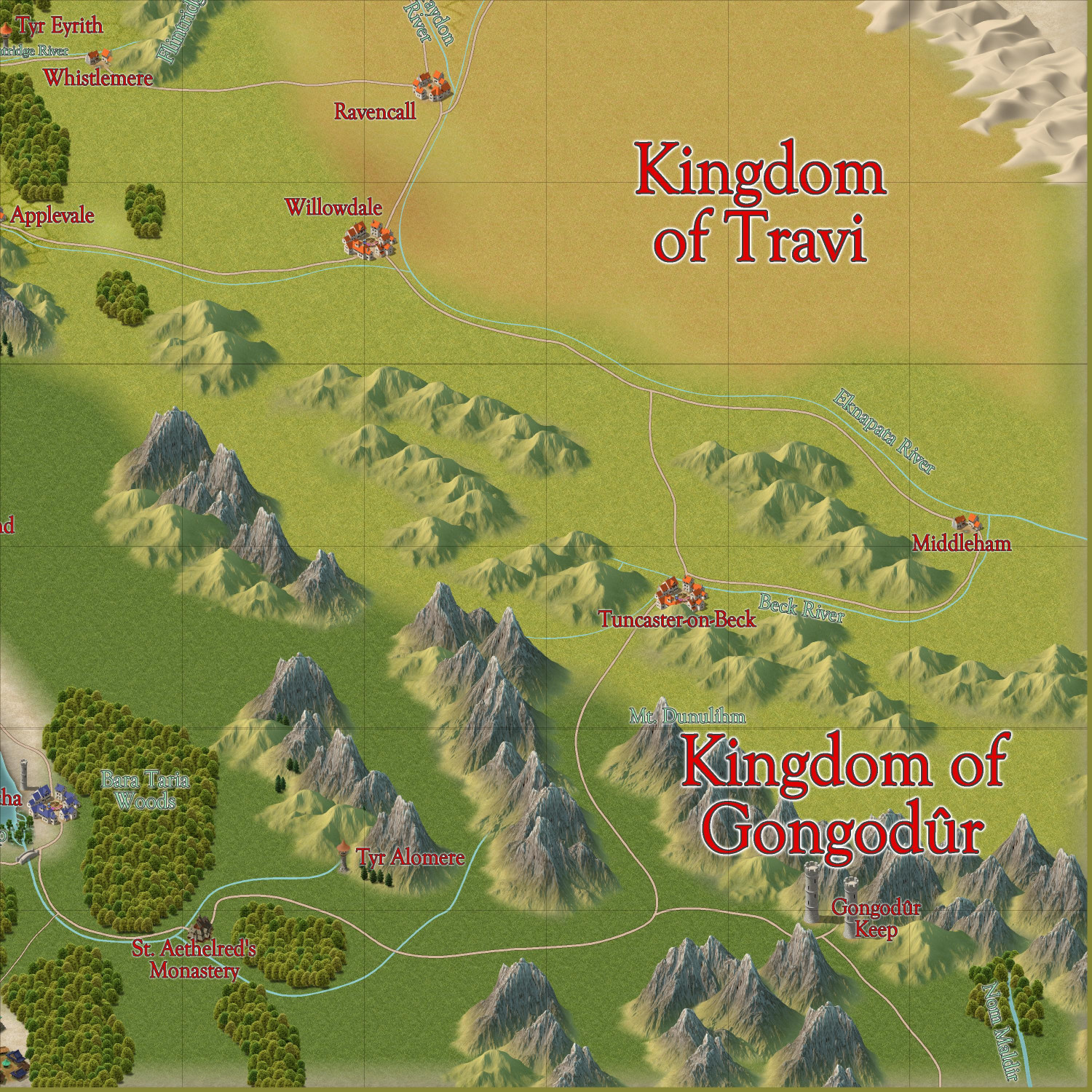
[WIP] Community Atlas - Gold Coast, Doriant
I've been working on a 1000 x 1000 mile part of western Doriant that I adopted. (This is separate from the elvish town in Verinress Arl, Artemisia, that I adopted for the 1000th map contest.) I know that new maps for the Atlas aren't being accepted until October, but that's perfect because it will give me a chance to do more detailed maps of specific settlements and points of interest at the same time.
I previously posted about this map in a previous thread, but I've decided to rename it, so I'm starting a new thread.
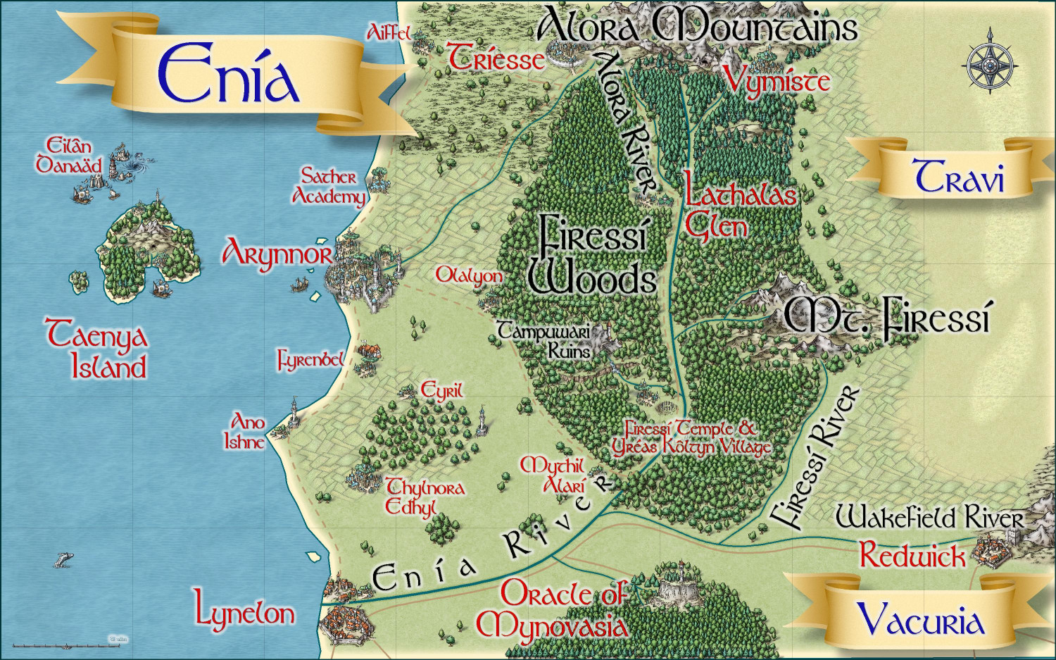
If it's okay, I would like to rename this the "Gold Coast," a regional term for an area so named because of the sandy beaches and tawny dried coastal grasses in the summer. It's an area that encompasses a region that includes a predominantly human kingdom of Vacuria, the inland human kingdom of Travi, a small elven kingdom to the north called Enía (a constitutional monarchy with a hereditary monarch and an elected Assembly), and a small dwarven kingdom in the southern mountains called the Kingdom of Gongodûr.
I still want to create a Borders drawing tool to draw the borders of each kingdom, but for now, this is what I have:
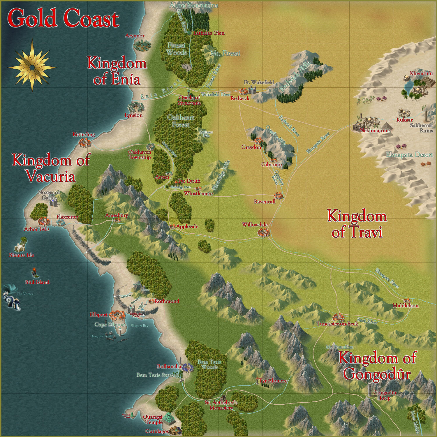
I have discovered that naming things is one of my bigger challenges. For several years, I've been maintaining a list on my phone of fantasy RPG character names, some of which could just as easily be used as place names. I also tried an old trick I used for naming gods in different pantheons in my campaign world: pick a language available on Google Translate and then look up words to find something tweakable for the god. (For a Thor-like god, for example, I might look up words for thunder, lightning, storms, etc. to find a word that could be modified a little to be a name.) And I also found a Wikipedia list of small towns in England and tweaked them (like changing the suffix from -ford to -port). And there are also a whole lot of patterns: a river that flows from a mountain may take its name from the mountain, and the village beside the river might as well.
Questions:
- What did I miss that should be named?
- Do you have any changes to recommend for fonts, font colors, or sheet effects on text labels?
- Any other thoughts?
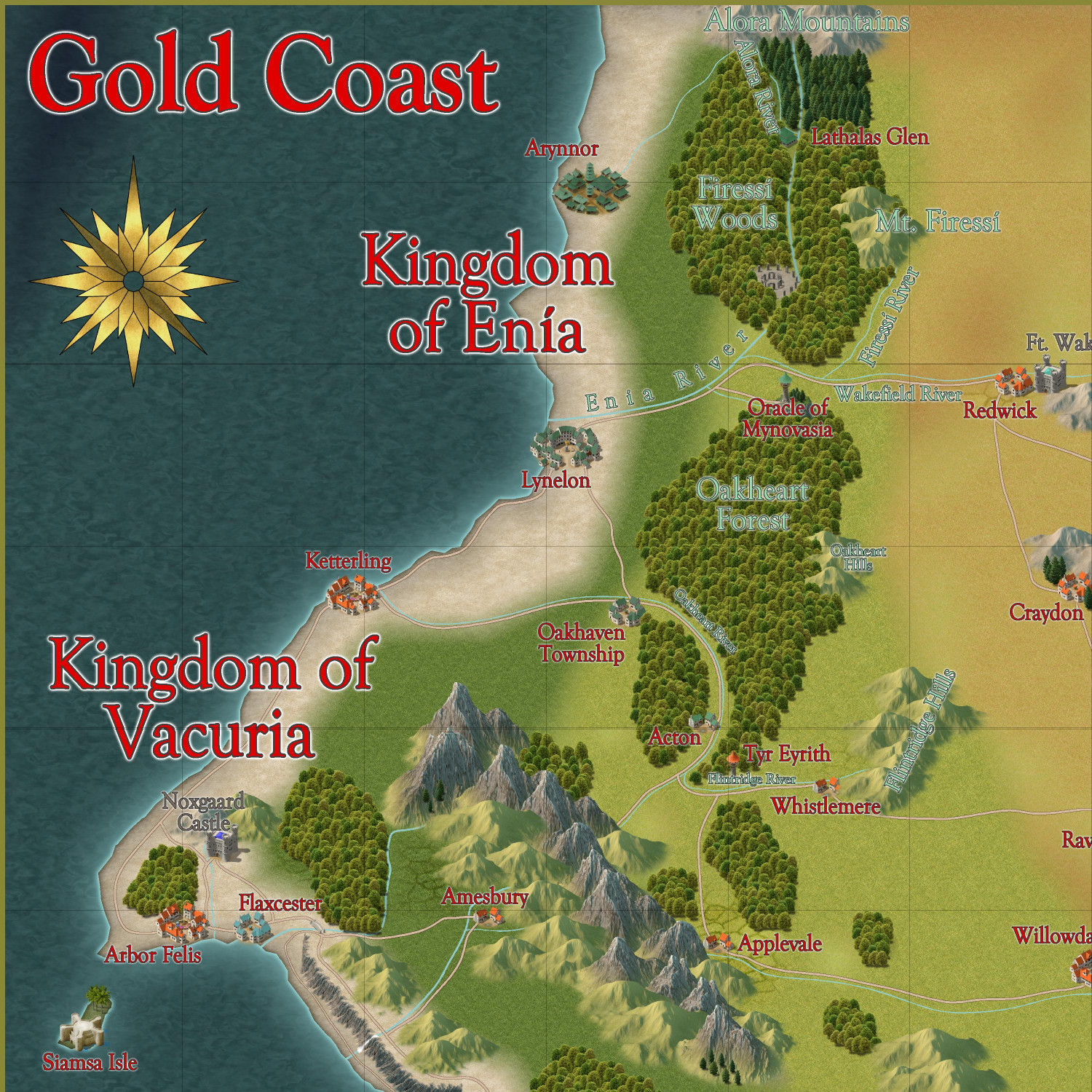
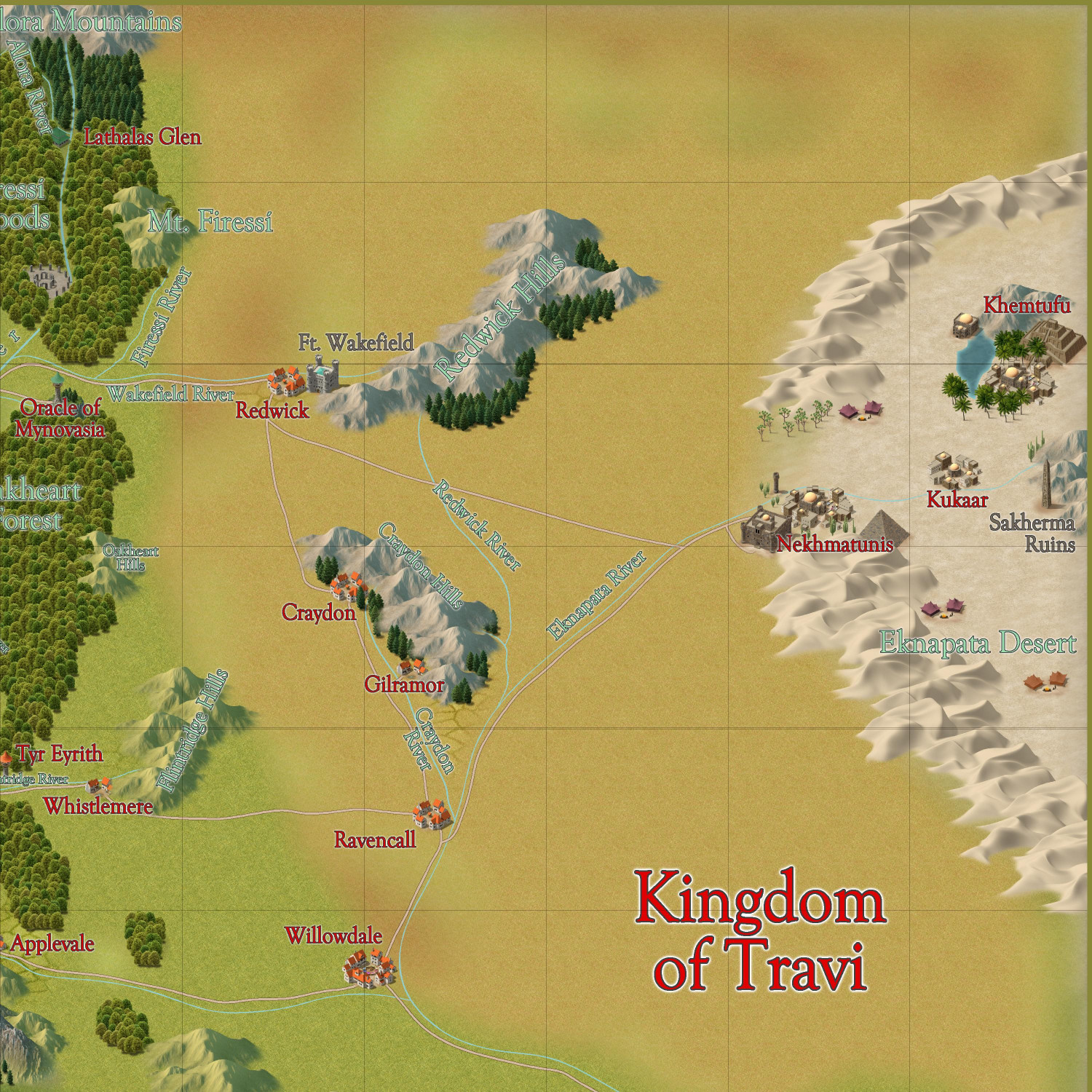
Here are some zoomed-in views to make it easier to see. In the future, would be better to post the larger map in my galleries so that folks can zoom in?

-
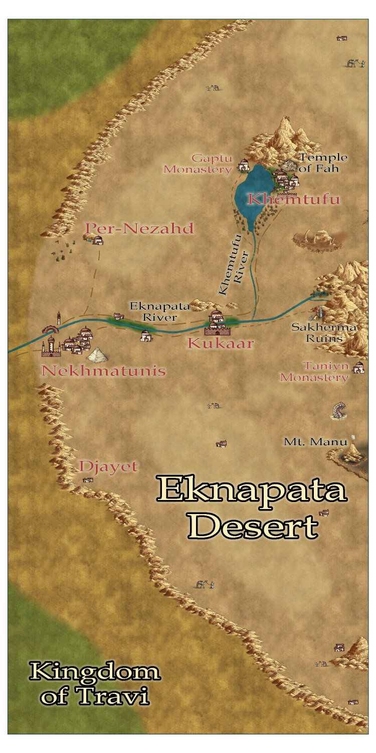
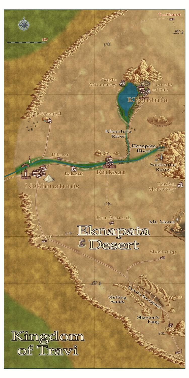
[WIP] Community Atlas - Eknapata Desert
I am writing up the description for the Eknapata Desert area of Gold Coast region of the Community Atlas. It was designed using the Scorching Sun annual. Any feedback on the map before I submit it?
-
Community Atlas 1000th map Competition - with Prizes [August/September]
Hi @Quayuazue! I think you’re describing a different place than mine, but just in case, I wanted to show you the place I’ve already adopted. It’s the village in the red box here:
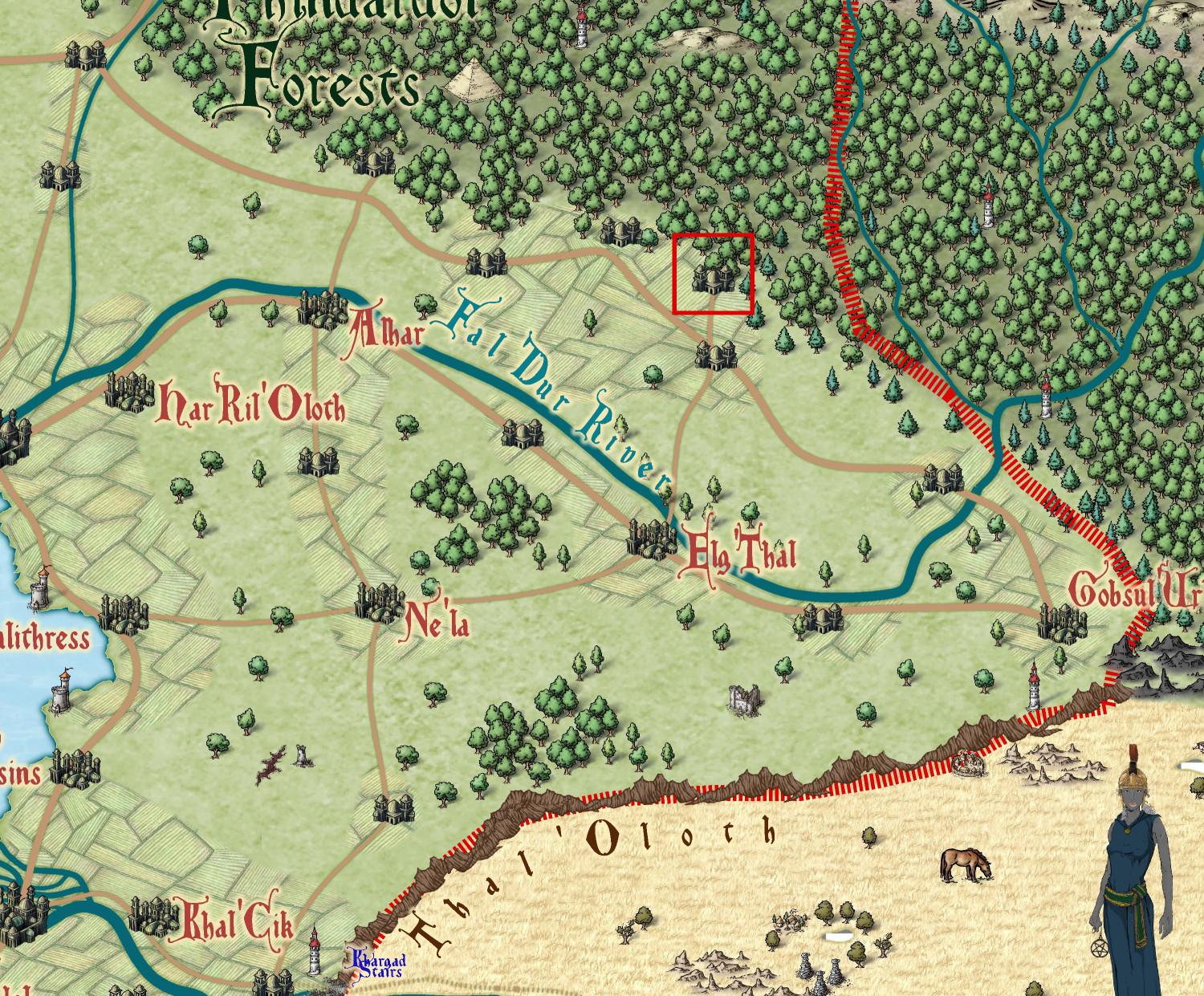
I’m looking forward to seeing your approach to these villages!


-
[WIP] Atlas Contest - Yréas Kóltyn Village (Kingdom of Enía, Gold Coast region of Dóriant)
Related to this village: I am planning on submitting an intermediate map of the Kingdom of Enía portion of the Gold Coast. And now I'm thinking that I might also do another map of just the Firessí Woods. I think it might be easier to do the Firessí Woods map now than after this temple village is added to the Atlas.
If I do create a Firessí Woods map, are there any sorts of adventure hooks or mapping possibilities you'd recommend including? I have the Tempuwari Ruins, which were meant to provide a place for an adventure reminiscent of the opening scene of Raiders of the Lost Ark. Other than adding a few more tiny elven hamlets, and maybe a few cave openings in hills, are there other mapping/adventure hooks you'd like to see?

-
[WIP] Community Atlas Competition - Artemisia - Spiros Isle - Aretizo village
This is really lovely. My only ever-so-slight feedback is that my old eyes are finding it a little difficult to read the legend, so I would consider increasing the opacity of the background fill/color slightly.
-
Issue with beach on Spectrum Overland
One other thing just occurred to me. See where it has a Blur Radius of 7? If you want bigger beaches, increase that number.

-
[WIP] Community Atlas - Eknapata Desert
Per Quenten's suggestion, I have been playing with the Line Styles for the roads. I didn't try creating a custom one, but I did try some of the other presets, and they didn't really work. I also tried checking the Paper Scale checkbox, and that had weird effects when I zoomed in.
Here's an attempt that sets the roads to be solid and leaves the guided routes as dotted lines. I like that it makes it a bit clearer which ones are actual roads. I will also put it in my WIP gallery to make it easier to zoom in. Thoughts?

-
First Time Mapper, First Time Poster, Long Time Struggling Learner
Welcome, Matthew!
I agree wholeheartedly with Ricko's recommendation to start with Joe Sweeney's videos. I owned the software for many years, trying to teach myself how to use it through the PDF manuals and fiddling around with it, but could not make any sense of it. I would peek at this Forum and admire everyone's beautiful maps, but could not make any sense of the software. Then I stumbled across Joe's videos and everything clicked.
Joe's videos are old, but still relevant and give a good foundation for the software. Once you've watched those ones, I would recommend checking out more videos here:
https://forum.profantasy.com/discussion/10519/video-tutorials/p1
The viewing order of those videos that I think may be most helpful (in order to get a foundation before tackling more advanced subjects):
- Joe Sweeney
- Dogtag's and Josh Plunkett's
- Learning CC3+ Section
- Quickies
- Campaign Cartographer Concepts
The ones in the section called "Blog Videos" accompany a blog article on the same topic, so I would recommend tracking down those blog posts. And the ones under the Live Tutorial section are fantastic, but most are not focused on a single technique or tool, and some are more advanced than others. I would try to get a good grounding from the other videos first, and then consider the older Live videos before the newer ones unless you see one on a specific topic that you think will be helpful. The Live videos are also really enlightening about the possibilities with the range of add-ons.
I resisted watching the videos for a long time because I was impatient and thought I could read the PDFs faster than watching a video. And that clearly didn't work for me: I bought the software in 2017 and didn't start watching the videos until mid/late-2023, and didn't make any maps until then either. But honestly, watching really made everything fall into place for me. Plus, I just love seeing someone start with a blank canvass and bring it to life to become a work of art. It's like watching Bob Ross painting videos. I've not only learned techniques from the Live videos, I've also been creatively inspired by them, too.
-
[WIP] 1000th Map Competition: Elkton, Alarius North Central
I have been looking forward to seeing what you do since you first claimed Elkton.
Also: DD4 things! Squeeee!

