Royal Scribe
Royal Scribe
About
- Username
- Royal Scribe
- Joined
- Visits
- 9,535
- Last Active
- Roles
- Member
- Points
- 3,353
- Birthday
- February 5, 1968
- Location
- San Francisco, California
- Website
- https://legacy.drivethrurpg.com/browse/pub/31814/Royal-Scribe-Imaginarium
- Real Name
- Kevin
- Rank
- Mapmaker
- Badges
- 16
Latest Images


Reactions
-
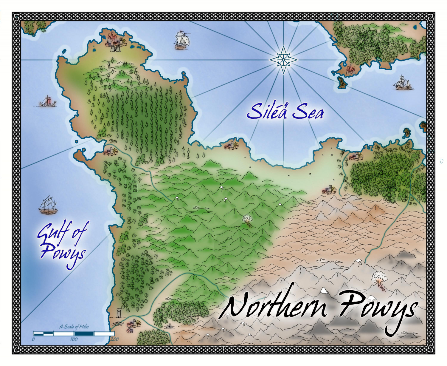
[WIP] Northern Powys (Sarah Wroot Revisited)
Reinstalling seems to have done the trick. Still had to manually delete the lines that were already there, but the lines weren't reintroduced when I redrew more farms and forests. Thank you!


-
Community Atlas 1000th map Competition - with Prizes [August/September]
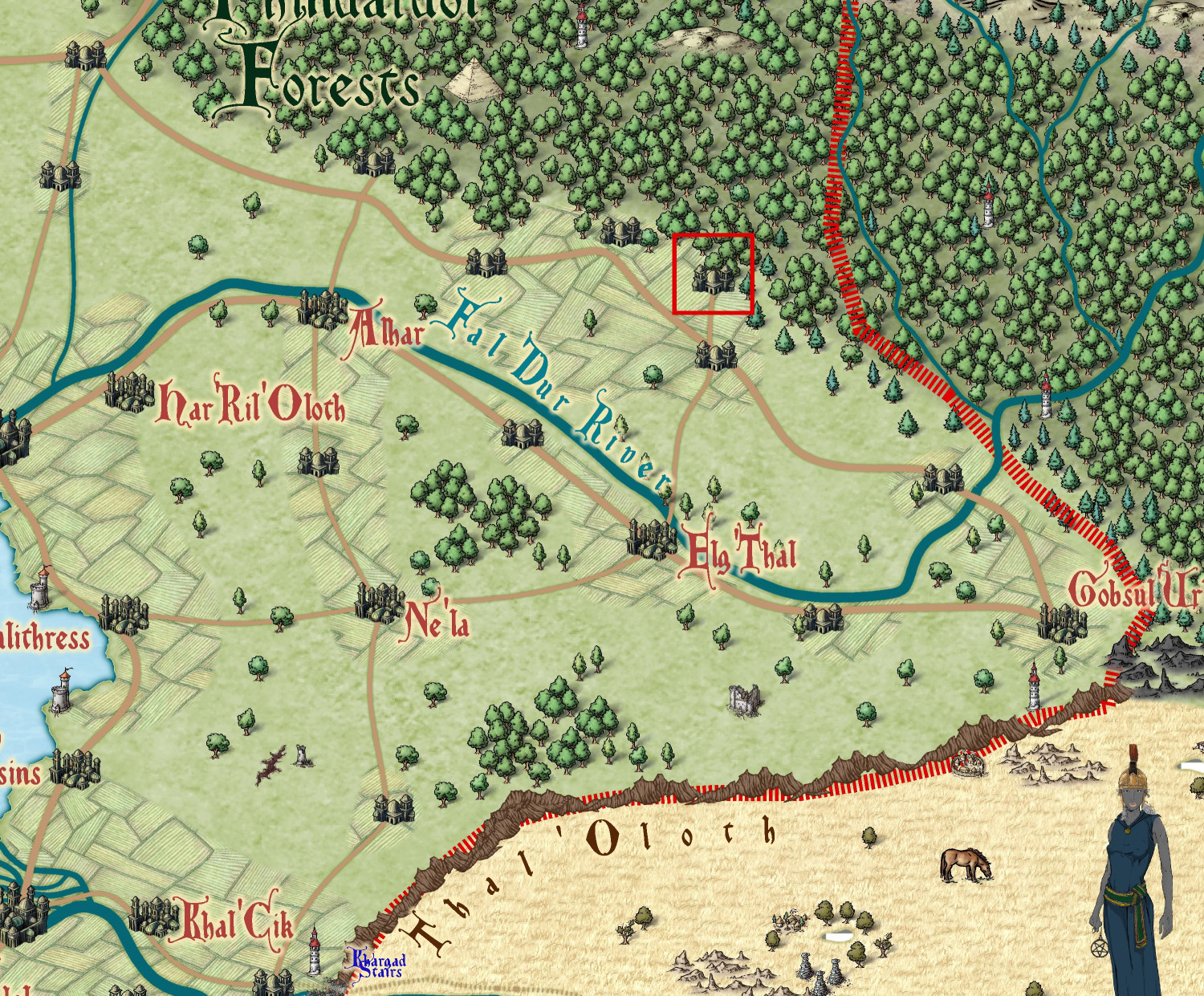
May I adopt this little unnamed elven village marked in the red box on Virinress'Arl? (Quenten, since you did the parent map, please let me know if this is encroaching on your future plans.)

-
[WIP] Lair of the Red Wyrme
Maybe that’s what took out the one at the base of the erupting volcano.

-
[WIP] Community Atlas - Gold Coast, Doriant
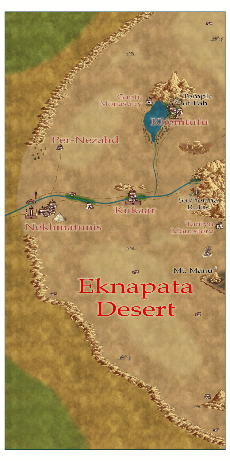
Here's an area map of the Eknapata Desert region on the northeast corner of the Gold Coast map. I decided to do it in the Scorching Sun annual. The mapping guide for the annual recommended Mike Schley Overland as a complementary style for additional symbols, so I used that for the pyramid at the city of Nekhmatunis, the ziggurat at the city of Khemtufu, and the half-buried statue and obelisk at the Sakherma Ruins. I also threw in a few of his camel-with-guide symbols to represent nomadic tribes, and a sandworm just for fun. There are a few more villages, too, and another monastery that I figured were too small to be on the parent map for the entire Gold Coast region. I also added a volcano, but figured that would be on the parent map. Since the parent map hasn't been submitted to the Atlas yet, I went back and added it to the parent map, too.
I'm enjoying the opportunity to try out different map styles with this project. I plan to design one city with Mike Schley's Mideastern symbols from SS5, and another with the Desert Oasis annual.
-
[WIP] Research Saucer Shuttle
Here is the saucer shuttle from below.
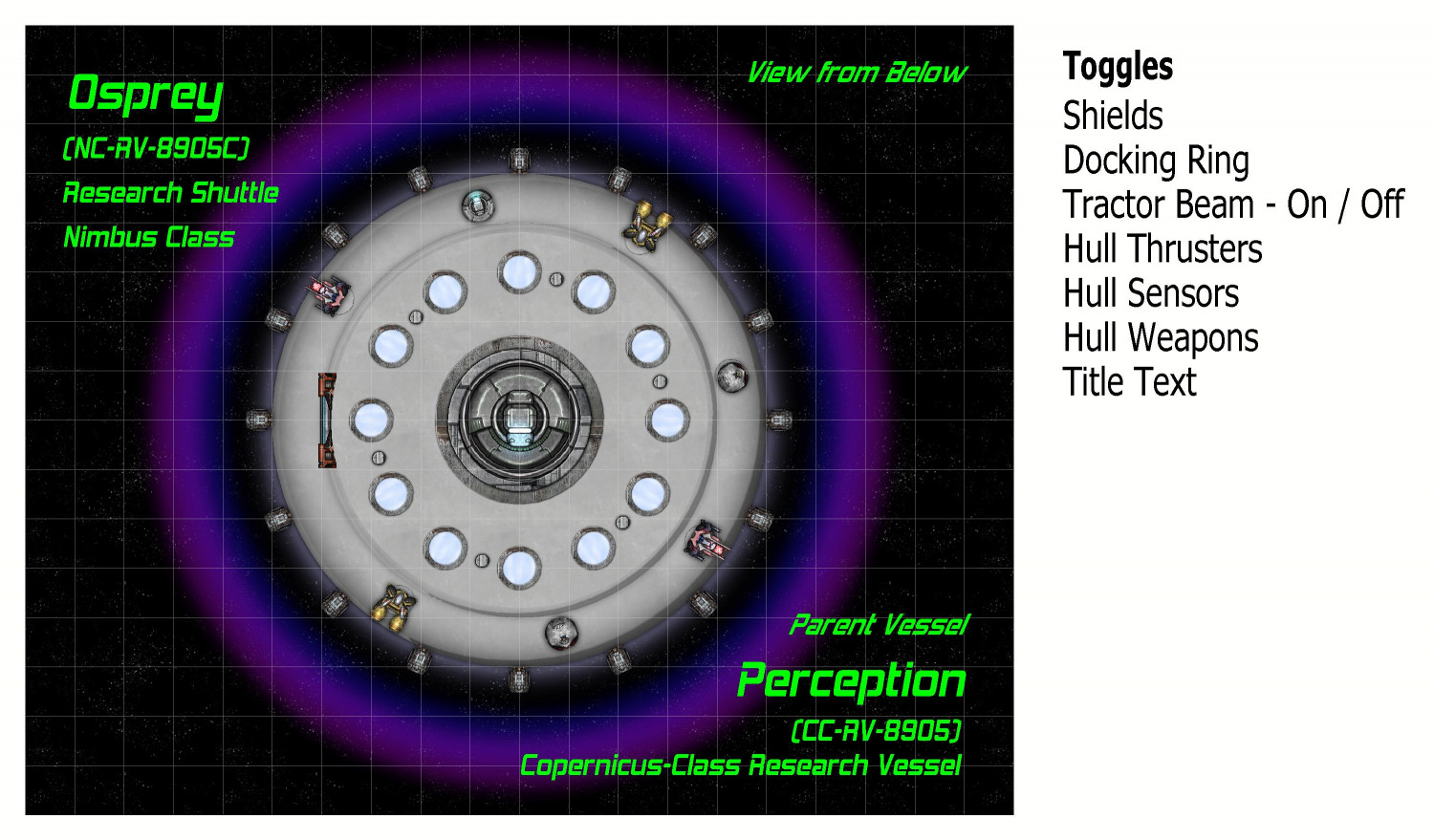
I named this shuttle The Osprey. It is of a class of saucer ships that I've named a Nimbus Class. These shuttles are assigned to either a space station or larger interstellar vessel. In this case, it is part of The Perception, a research ship from a class of ships that I am calling the Copernicus Class.
On the left side, the airlock hatch can be opened planetside to extend a ramp. The very center has a docking ring for connecting to The Perception or other vessels or space stations. The twelve glowing disks are meant to be some sort of magnetic propulsion thrusters (the side thrusters are more for steering and course correction, not liftoff or acceleration). They were made using one of the sun symbols that come with Cosmographer. And the six metal disks are meant to be places where retractable legs can extend when on planet.
The text labels on the right are for toggles in the FCW file. They are off the map border and normally don't print, but I wanted to show it to you. They are mostly on/off toggles, but the Tractor Beam is a little more complex, which I will get to. Here is the syntax for the thrusters, as demonstrated in Remy @Monsen's recent Village Battlemap tutorial. It toggles between hiding and unhiding the layer called "Symbols - Thrusters".
GOLAYER BACKGROUND
TOGL Symbols - Thrusters
NULL
As Remy's tutorial explains, the GOLAYER line is done to make sure you aren't on the layer you're trying to hide, because active layers cannot be hidden. And the NULL line is to make sure that toggling a layer is not your most recent command.
Here's the map with the center docking ring open:
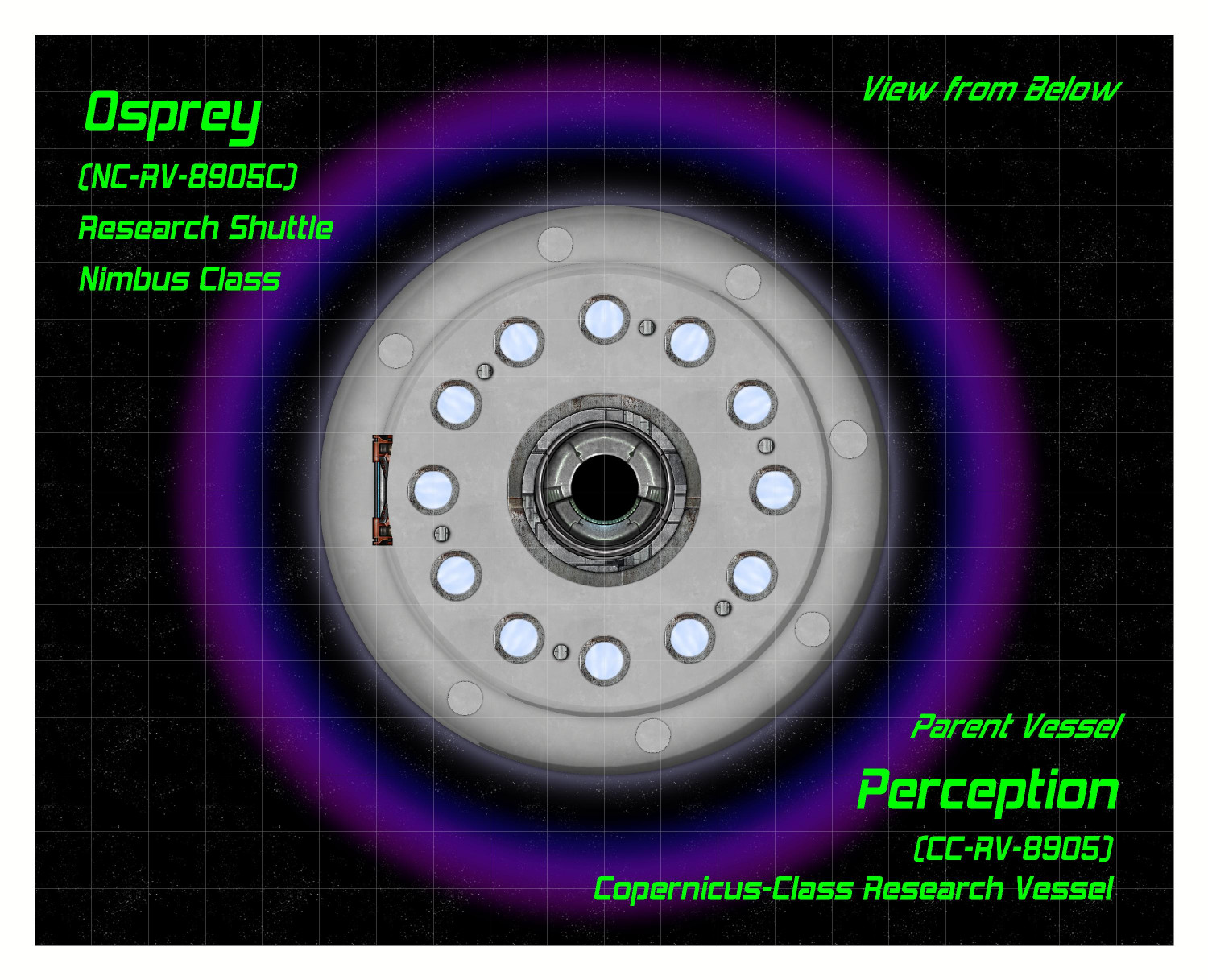
The docking ring is actually two separate symbols, with the closed hatch symbol on top of the open hatch. The "Docking Ring" toggle hides or unhides the sheet that the closed hatch symbol is on, allowing the hatch to go back and forth between open and closed.
In addition to using the center hatch for docking with other vessels, a tractor beam can be activated to lift cargo or specimens into the shuttle (like cows or battered pickup trucks in the deserts of Nevada). Here is the tractor beam activated (it's one of the varicolor suns):
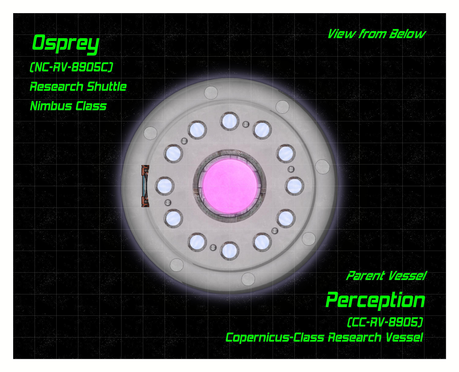
The toggling of the tractor beam was a little tricky. I suppose I could have made it just be on top of the hatch symbols, but I decided to make it as separate "on" and "off" options. Clicking "on" simultaneous hides the layer that both docking hatch symbols are on while unhiding the layer that the tractor beam is on. Here's the syntax for turning it on:
GOLAYER BACKGROUND
HIDE Docking Hatch
SHOW Tractor Beam
NULL
Clicking the "Off" link reverses this, hiding the tractor beam layer and showing the docking hatch layer.
On to the Habitat and Engineering decks!

-
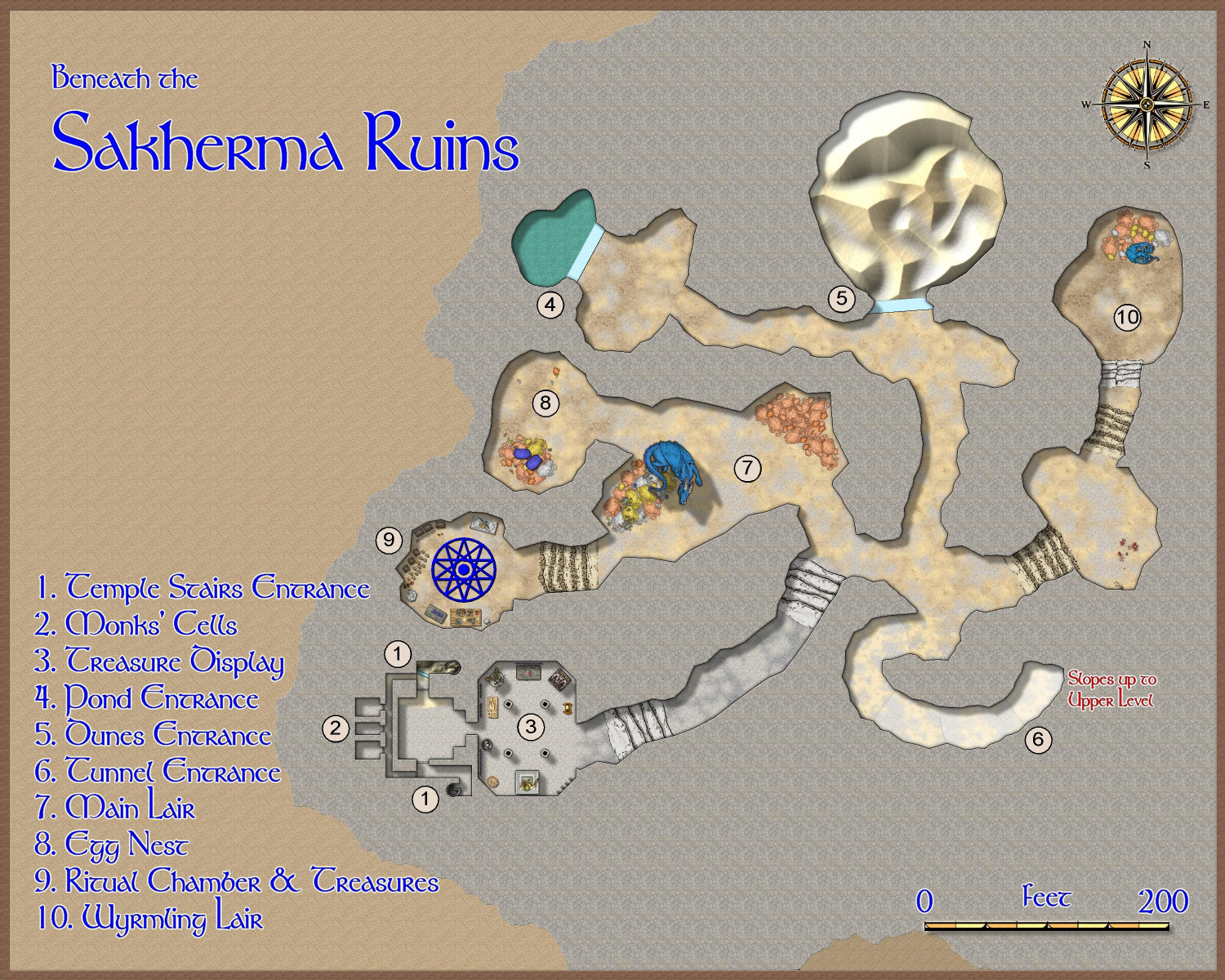
[Atlas Submission] - Doriant - Gold Coast - Eknapata Desert - Sakherma Ruins
Below
No toggles.
Description
Sakherma Ruins
Below
1. Temple Stairs Entrance: Here, the stairs from the temple ruins above descend to human-created chambers. The northern staircase is blocked by sand, but a glass wall keeps the sand from filling the chamber below. The southern staircase is relatively unobstructed.
2. Monks’ Cells: These three chambers appear to once have been home to the monks who maintained the original temple. Game Masters: At the Game Master’s discretion, one or more of these rooms may be occupied by the dragon’s humanoid allies – kobolds, dragonborn, or perhaps sorcerers with a draconic bloodline.
3. Treasure Display: This room is practically cluttered with statues and tapestries. Game Masters: Here the dragon has created a veritable museum showing off its favorite treasures, including a display of magical armaments.
4. Pond Entrance: At the base of the pond, a mighty glass wall keeps the pond’s water from flooding into the tunnels. Game Masters: The dragon can magically pass through the glass without harming it to bathe in the pond, or for another escape route to the outside surface.
5. Dunes Entrance: A great glass wall keeps the sand dunes from pouring into the caverns. Game Masters: The dragon can pass through the glass without harming it in order to reach the surface of the desert, or to devoir travelers camping there.
6. Tunnel Entrance: This tunnel connects the upper and lower caverns.
7. Main Lair: It is readily apparent, if visitors haven’t already figured it out, that this is a dragon’s lair. Piles of coins, particularly copper ones, form its bed.
8. Egg Nest: A blue dragon’s egg lies on top of a pile of coins infused with the dragon’s magic to keep the egg warm when the dragon is away.
9. Ritual Chamber & Treasures: Here the dragon keeps most of its magical treasures. The dragon may also shift into human form to conduct arcane rituals from time to time.
10. Wyrmling Lair: The bedroom for the dragon’s “teenage” child.
-
Community Atlas submissions: the Gold Coast (Doriant) and areas within it
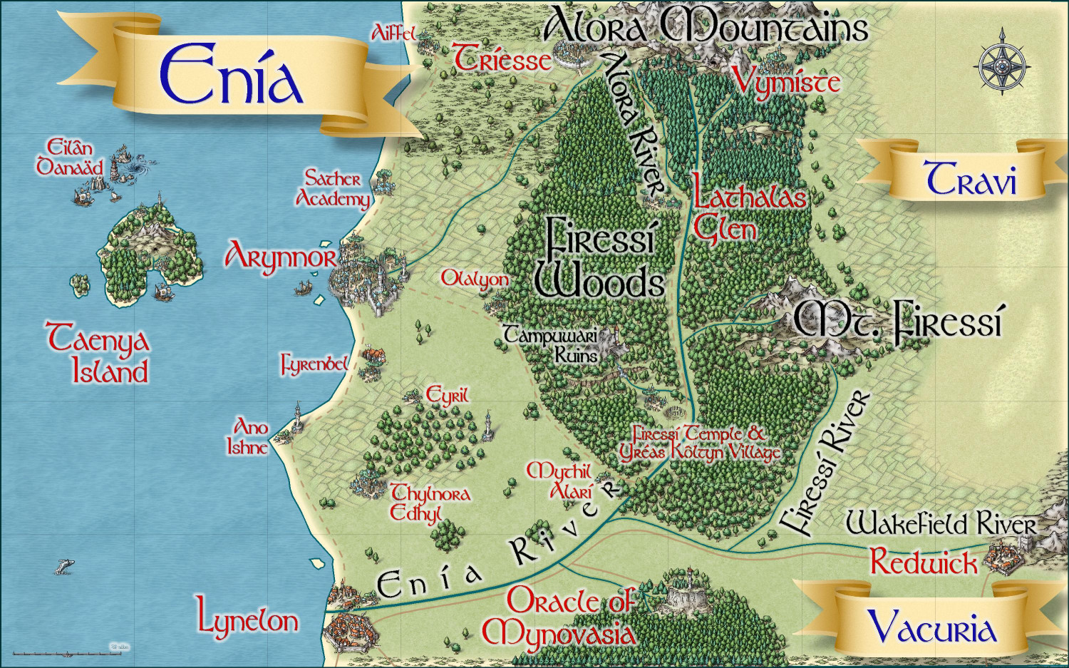
I'm ready to submit this intermediate map for the Kingdom of Enía, along the northern edge of the coast for the parent map above. This map will be the parent (or possibly grandparent) for a few villages I will be submitting to the contest.
Primary Style: Mike Schley Overland
Toggles: BORDERS/POLITICAL to show/hide political borders
Here is the FCW along with a PDF of the description:
Should I do a plain text file that strips out the accent marks? Here's the text of the description (with accent marks):
The elven kingdom of Enía is the northernmost coastal kingdom in the Gold Coast region of Dórian. The human Kingdoms of Vacuria and Travi lie to the south and east, respectively. Enía is significantly smaller in both population and geographic size than its neighboring kingdoms. The kingdom’s borders are marked by the Enía River along its southern border, and the Firessí River and edge of the Firessí Woods along its eastern border.
Enía is governed by a hereditary monarch who is advised by two political bodies: the Council of Adept Mages, and the People’s Assembly. The Council of Adepts consists of those archmages and adept mages able to cast the most powerful spells. The People’s Assembly includes a hundred citizens elected throughout the realm.
Major points of interest include:
Arynnor: The capital of Enía, called the “city of glass.” Here, elves pioneered glassblowing techniques both for ornamentation and practical purposes. This includes a technique to make glass nearly as strong as steel, which has allowed the elves to safely cover their towers with brightly colored glass domes.
Sather Academy: To the north of Arynnor, Sather Academy is an institution of higher learning with academic classes of all sorts, from history to astronomy, poetry to accounting, but it is most famous for two things: its Bardic Colleges, and its Arcane Academy for the formalized study of wizardry and arcane lore.
Lynelon: The coastal city on the northern bank of the Enía River, Lynelon is a bit smaller than the Vacurian city of the same name on the southern bank.
Firessí Woods: Much of the realm is covered by a mighty forest, the Firessí Woods. The woods are home to numerous tiny elven hamlets along with a few notable features. Towards the southern edges of the Firessí Forest lies an ancient henge of standing stones, the Firessí Temple, erected to honor the elven gods. It is the holiest place in all of Enía, and the seat of power for the Archdruid of Firessí, the most powerful religious figure in the kingdom. A small village, Yréas Kôltyn, provides a home for the elves who tend to the temple and provides accommodations for the temple’s many pilgrims. To the northwest of the temple lies the Tampuwari Ruins, the haunted ruins of a people so ancient, they disappeared long before the elves moved to the area. The ruins are best to be avoided. Farther to the north, Lathalas Glen is a town built up around a monastery of the same name.
Taenya Island: The small island is home to a few small villages and hamlets of wood elves Just to the north of the island among rocky reefs, Eilân Danaäd is a harbor village of sea elves with homes both above and below the waves.

-
CC4 Overland Development Thread
Love, love, love those craters. My family has a cabin less than 2 miles from the rim of Crater Lake, Oregon, so I have an abiding love of calderas.
-
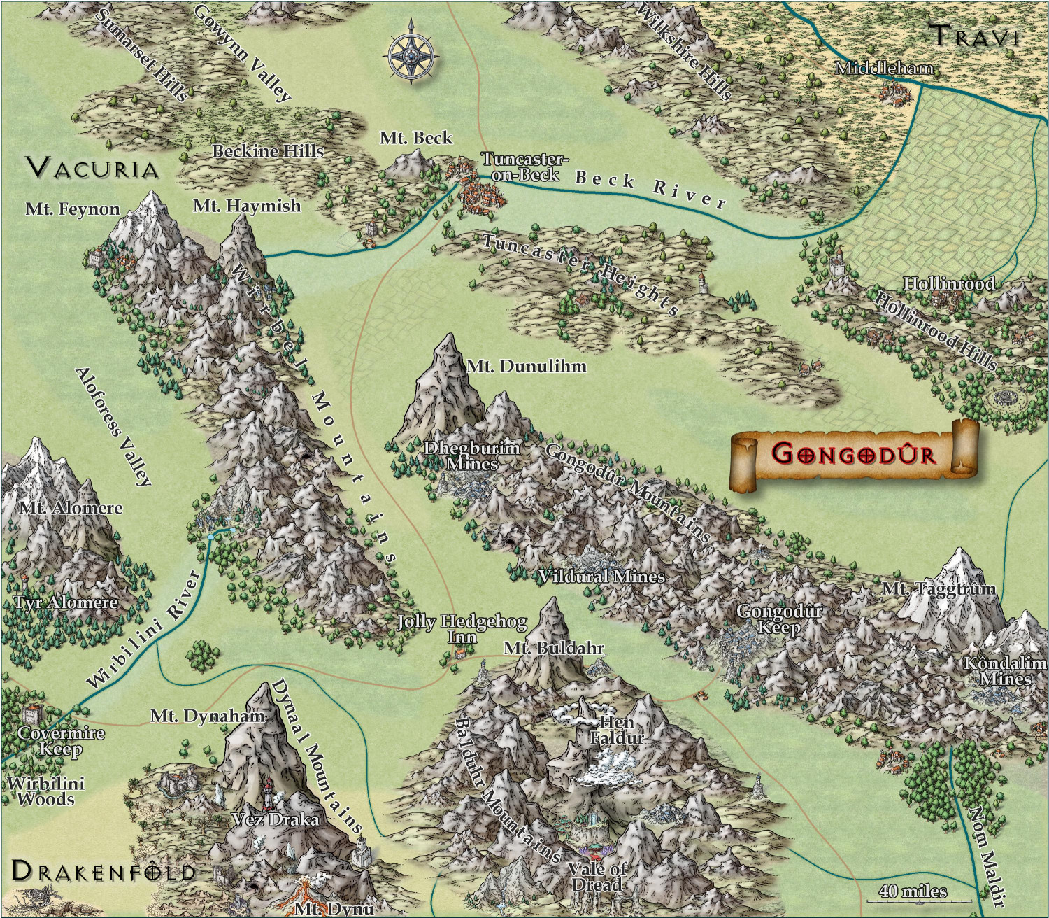
[WIP] Kingdom of Gongodûr
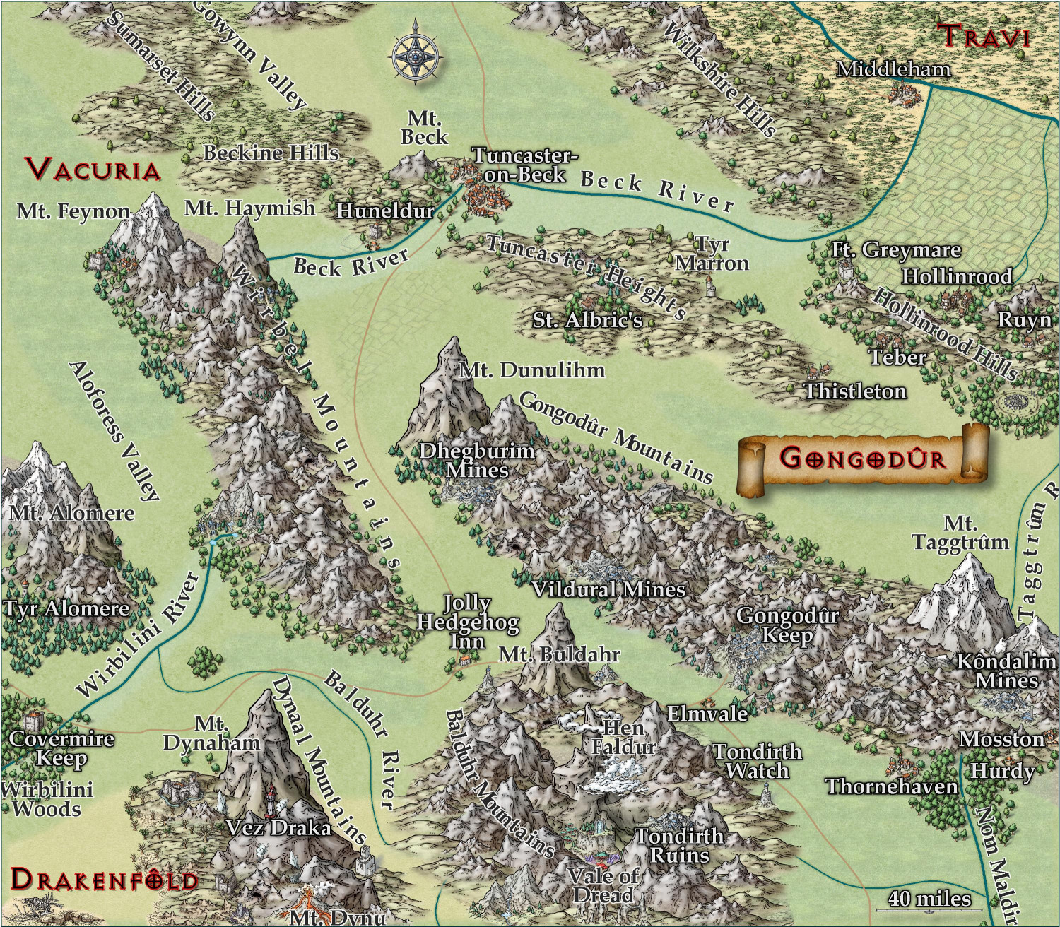
I changed the two labels to near-white for settlements and near-black for geographical names. (Let me know if you think I should reverse that, with dark names for settlements and light ones for geography.) Playing with text-along-a-curve for some mountain ranges and rivers, and moved some to the side to make them easier to read. (For a few of them, I had to explode the text and ungroup temporarily to adjust the kerning.) Made some effects changes to the political borders but I need to redraw them to reflect the river changes. Oh, and I embiggened the compass and moved it. It also has an inner glow to make it stand out a little.
May not have more time today to work on this -- about to head out to a family function for the day. Hoping to finish it this weekend.

-
[WIP] Kingdom of Gongodûr
Still working on this. Text is slightly larger, and the glow is as well. Added more names, though I still have a few more rivers and settlements to do. Should I be naming the roads, too?
I am think about putting country names, settlement names, and geographic names each on a separate layer so that end users can toggle them on and off as desired. They're already on separate sheets, though, so maybe that's sufficient for toggling individually, and a single layer for all of them to toggle all names on/off simultaneously?