

Community Atlas WIP - Panaur region of Doriant
 Don Anderson Jr.
Mapmaker
Don Anderson Jr.
Mapmaker
So besides all the other mapping projects I did want to contribute to the Community Atlas. It teaches me quite a few things and makes me feel good to add to the project.
I took a region in the lowest South East area of Doriant. A region called Panaur. Going to make it a bunch of Fiefdoms. Along with the Knights, will be some of the continents best shipbuilders.
The variety of trees they cultivate are kept hidden from other shipbuilders. They protect the trees from jealous competitors.
The climate is harsh in areas, but it is consistent, so every copse of trees can be assured to grow strong.
First map is the region I have chosen
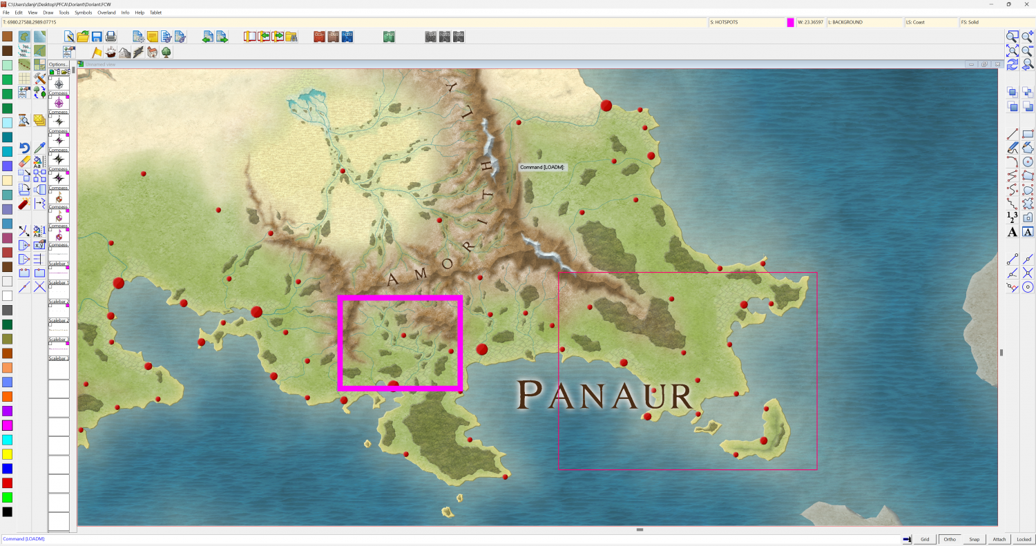
Next map is the copied region from the main map, with all the city and town locations. My main starting point.
Last map is the current state. All the important details from the main map are filled in. Now to add extra character to the map. Lots of items will probably be tweaked a bit. Text definitely is a placeholder for now.
I will add in political boundaries for all the Fiefdoms. I looked at the map and realized the coast should be redone with more fractalization. It is way to smooth in my opinion.
Future plans are to do a few of the cities. Maybe do one isometrically. Also to do one map in perspectives. Maybe even a dungeon or two. Maybe even a small regional map in a totally different style. Kind of adds some pressure for me to work on my map making, and trying to improve.
Please do be kind, it is a WIP and I haven't worked on effects to much. The main forest for sure needs some TLC.


Comments
Don't forget that aside from adding more character to the coastline, you can also add smaller islands there in places to help break up that "smoothness" aspect, much as other features too small to have been added on the original larger-area map can be added inland. What's shown as a peninsula on a large scale, might be really an island with a tidal causeway headland instead when you start looking closer, say!
I'd definitely recommend using your Atlas mapping to experiment with different styles; it's what I've been trying to do for some years now! It does indeed push you into thinking in different ways about mapping, and trying out new things in terms of how to use the program.
Here is some further progress on my map.
Things I haven't done yet.
Text for rivers. I am not going to do roads, they are un-named, just arrows to destinations.
Text for biome's
City text. I numbered them with name, and will do that with Biome's so I can do a legend with all things. The legend will go in the sea on the right side.
Political borders for the Feudal states.
I am open to further ideas. If it was my own world I would add whatever I feel, but being part of the community map. I am struggling a bit to enhance the map more. The central forest has differing tree colours as the shipbuilders grow huge regions of specific tree types. So it may look odd to some people but it truly serves a purpose.
I am open to further ideas. If it was my own world I would add whatever I feel, but being part of the community map. I am struggling a bit to enhance the map more.
As long as your ideas don't clash with/contradict anything that's been written about the continent and/or nearby areas already (see the map notes in the Atlas FCW files for those there are - not everyone adds some to their maps), and the overall details from larger-scale already-mapped areas aren't changed significantly, you're pretty much free to devise as you please. You could even devise some undersea mapped areas, if that appeals 😁!
As Wyvern says, you can add pretty much what you want. The idea behind this project is that everyone can bring their own ideas to the table. A local map should obviously be consistent with the regional map it is taken from, but the general idea is to make it interesting by adding features and locations that wouldn't have been mapped at the greater zoom of the parent map. The marked city locations on the parent map are naturally going to be the largest cities in the region, but as you drill down to more close-up maps, smaller cities and other interesting locations will naturally start to appear. So make it yours, add your own lore to the area (if you want to), and make it an interesting place for subsequent mappers to pick for their maps.
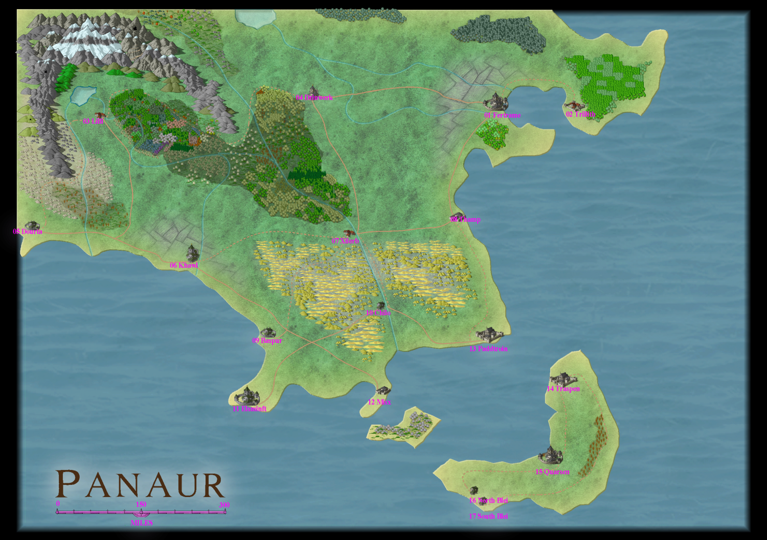
Updated main map
Still have to do some text, and tweak what is done for text.
Here is a regional map for the bay in the North East
First of three towns. None of which I have placed on any of the upper level maps yet.
Stehltuhn
Shellaigh
Metilee
Main map is almost done, with the exception of doing text and some points of interest.
I may add more regional maps, so they can tie in the town maps I completed.
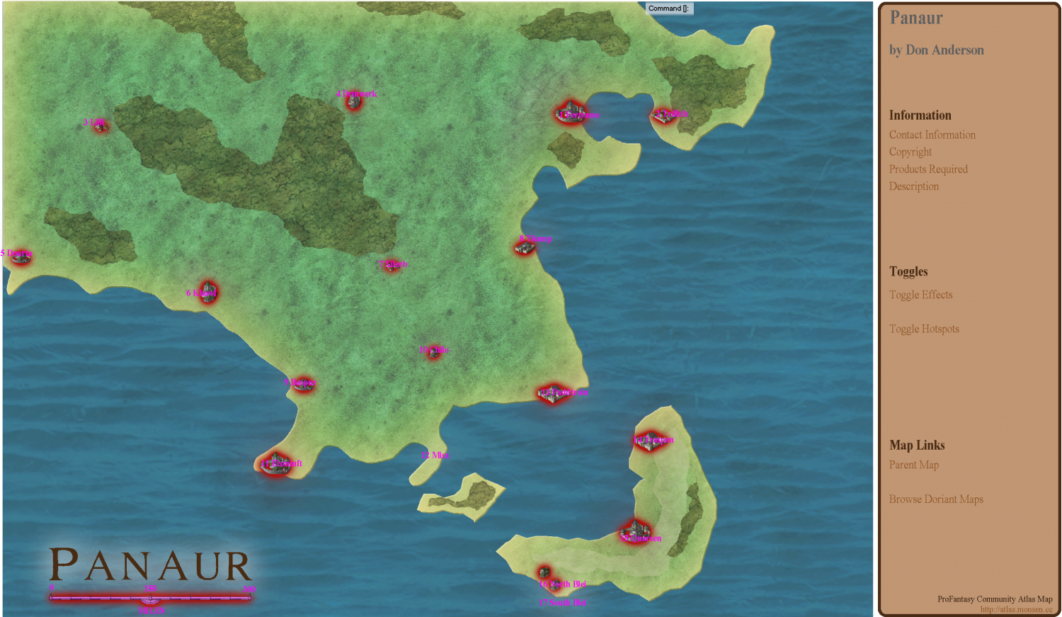
The red dots were the reference points from the main continental map for towns and cites. The grid is only there for the index.
I added wind markers to make sense of the biomes in this area of the continent. Of course hidden on their own sheet. Mostly reference for myself.
First foray with a different take on perspectives. Only an hour or two into this one.
This is the Isometric view of Metillee, the village pictured just above.
Have some tweaks to do with layer separations and sending other items to the back.
Hopefully with some sheet effects and more polys here and there, as well as more vegetation, I can get it to look decent.
Scaling stuff in all the distance regions is going to be the tough part. It's kind of close now, but not perfect.
Had a little serendipitous moment placing hills and it placed some empty spots that look like they could be the river.
Update on my mapset for the Atlas. 15 maps. Half of them are 95% or more done. Some tweaks for some of those.
One main map linking some of the camp maps is the least done at about 10%
LEVEL A CONTINENTAL REGION
Panaur
LEVEL B REGIONAL and a city in that region I had the city one done before, but somehow overwrote it. Now I have to redo it.
Two cites down south Khawl and Stehltuhn
LEVEL C MAPS
LEVEL B REGIONAL
4 connecting maps
Hmmm uploaded 10 maps. 5 more to go. (spam limit?)
Had 4 more local area maps Father map is the undone island.
Remy said he didn't like buttons. So I made the campsite into a dark and light version.
The new temple from the mapping session is going to be like a player treasure map.
Remy said he didn't like buttons. So I made the campsite into a dark and light version.
It's not that I don't like buttons, it is just that setting up toggle switches is simply more work than just handle a straight-forward map. But generally, a map with toggles are preferable to having multiple maps of the same location. The linking system in the atlas is primarily designed to link different locations together, and doesn't work as well when linking two different versions of the same map together, primarily because there is no sensible way to indicate a linking spot on the map itself for that purpose, so it will only be in the sidebar (or below the map in the web version viewer)
OK I will try figure that out.
Turning shadows off, while turning light on.
Time to get the learn on.
Do note though that day/night maps can be hard or even impossible to do with toggles. It is easy to hide/show layers and sheets, but macros can't toggle the individual effects on a sheet.
I think I found a work around with 2 sheets. If it was more of a complex map it would probably not work.
Thanks for the insight.
SO stoked.
Down to three maps to finish.
Shellaigh the map that got lost, that I have to redo.
Khawl the Isometric weird one.
And adding a button to make the campsite night and day.
Always wanted to contribute to the Atlas and now it's so close. Not all of them are works of art, or perfect by any means, but I think they are fair contributions to the project. Then it will be up to Remy to tell me all the shit I did wrong and have to fix. I am pretty sure it will be a big list LMAO. I dropped a few maps, but want to add in one more....I don't want to contibute 13 maps.
Hmmmm maybe a House floorplan, I think that's essentially the only one I haven't created in this set.
Then it will be up to Remy to tell me all the shit I did wrong and have to fix.
Some of the more typical things people forget are map title and other labeling, scale bar and compass roses, and they forget to use proper scale for the map. For the latter, when using Info -> Distance, the value should be what is expected. For example, if measuring along the a scale bar, the value in the dialog should match the displayed value on the scale bar. If the measurement come up wrong, it is likely that the entire map is scaled wrongly. Or if it comes up right, but the values on the scale bar doesn't match your intended scale for the map, it also means it is scaled wrong.
I have used your CC3 tools to scale other maps and it's awesome. So easy.
Haven't put any scalebars 0n any maps yet, nor compass roses. I'll need to find one that suits all the maps I guess.
Also started to do Map Notes for all the maps.
Down to one map. Shellaigh town.
I managed to do my first macro to create the day night for my campsite map. It wasn't working. Then I kind of figured the sheet that wasn't hiding had a space in the name. Deleted the space on the hotspot and the macro and all was fine. (didn't hide the hyperlinks for the screenshot)
Do I need to submit that macro as well? Or does it save to the map?
Ack have to change the map name, seeing as it's the same map now.
12 maps complete including all the map notes. That took a lot longer than I thought it would.
One map at about 70% completion.
Then the one more map I want to add.
How should I go about presenting the links to each child map? Should I just do a rectangle and add text for which map it links to?
I believe I read not to do any hyperlinks, because Remy has his system.
Map level A has 2 Regions and 2 city's
Map Level b1 has 1 town link
Map Level b2 has 2 towns, one local battle map and region(level c) to an island
Map Level c has two battle maps one links to a dungeon temple(level d)
I'm not going to submit them until Remy is recovered from his vacation.
If links are obvious (like a city map linking to the labeled city marker on an overland map), you don't really need to do anything. If it is harder to understand without a explanation, either just explain it to me in writing, or put a rectangle or something (with optional text) on a dedicated layer which I can just hide or delete when I am done with it. Just name the layer something that make it obvious that it is a temporary layer and don't conflict with the MAP LINKS layer I use.
I do not understand why this map is taking me so long. It's just dragging on for days and days and days.
No idea how many hours have been put into this damn map. I swear the first version took me maybe a day.
Mind you doing a lot of individual walkways, lots of different fences and such. Still haven't even touched vegetation. Lots of sheet tweaking to go as well. A few areas I need to flesh out, but drawing a blank.
This is another map that doesn't look great zoomed to extents, but it looks pretty nice at road level.
Looking good :)
The more detail there is the more interesting the map, but you have to stop at some point. The level of detail (LoD) in any one map is a tricky decision to make sometimes, but generally speaking if it's a city map and the detail you are thinking of including comes from a dungeon scale style, it's probably way too much detail unless it's something fairly large and relatively simply drawn as a dungeon symbol. That's an extreme example, but it's an illustration of what I mean.
If you're finding the mapping a drag, and not really enjoying it, it may be worth considering a broader-brush approach to the city overall - such as the Watabou style, that shows general areas only, with just a few important places highlighted, roads and general layout. Then if you feel so inclined, you could add detailed areas for selected spots as separate maps - that way, you don't need to worry about how the map looks zoomed out, and can pick area sizes to better suit the time and energy you have available for detailed mapping.
As Sue said, what you've shown here looks good in detail, but if it's not inspiring you, it may be worth a rethink, if only for next time.
I think maybe this is the map with the most detail I've ever put in. Mostly with the massive variety of fences, foot paths, sidewalks and grass textures. Probably why it feels like no progress. Past maps probably didn't have sidewalks of note. Most likely just drawing tool paths.
I like how you've managed to give neighborhoods distinctive looks with colors and symbol type choices. Like the desert/middle eastern house types in the lower left, the blue building complex (temple?) on the middle right, the eight gray buildings in the center top. And I really like the bridge. Some day I want to do a major city with a massive bridge inspired by the historic London bridge -- the kind with shops and residences on the bridge.
As for dragging on for days -- that happens to me with so many maps! I usually have half a dozen going at once so I can take a break from one (while the ideas continue to percolate) while turning my attention to another.
Kinda think of my maps as High Fantasy. Groups tend to stick together. Elves near Elves, Halflings near Halflings. Regional people together. and so farth, cept for mages. Further away the better.
My thoughts are to assume a majority of the population is illiterate. So they give descriptions of their houses. Mine is the aged cedar shakes behind the church. Or our business is on the main street with the green shingles.
I hear that about to many maps. This is the last in the set (maybe 1 floorplan) so I need to press on.
Yea I decided to just go with a dozen submission for my Region in the Community Atlas Project.
Finished off my Shellaigh map. I'm very proud of it. It looks sharp when it's zoomed in. I think it is tied for the best map I've ever done.
So that's one dozen maps wrapped up in a shiny litte bow for Remy to work his magic. (I sure hope I get good marks for this submission)
Here it is complete. On a side note, I added very few details on all my maps, so people can let their imaginations run wild. With this map I made a concious effort to really hide the few text labels used. Only used them to tie it locally to the other maps in the set.