

Myirandios - Hardin Region - Skalamark
 Quenten
🖼️ 124 images Mapmaker
Quenten
🖼️ 124 images Mapmaker
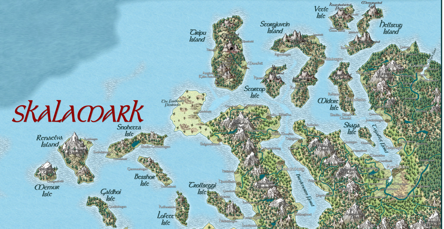
Here is the northern part of Skalamark. I made free use of Norwegian place names, some Norwegian translations, and the Viking symbols from Mike Schley latest monthly offering. I hope there are some more to come, for use in this hardy land - rather like Harald Hardrada's kingdom.


Comments
Well, I have amazed myself, and finished this map in a rather short time. A Norwegian feel, I hope.
Sorry the resolution isn't so good on the forum.
Sorry the resolution isn't so good on the forum.
In-post forum images needs to be kept to a reasonable level out of consideration for all the various users, but if you want to provide a link to a higher resolution gallery image, you can just right click the image thumbnail in the gallery and pick "Copy link" (Slightly different name in different browsers) and you get a link straight to the relevant image you can paste into the post.
Please do make sure to make it into a hyperlink though, and not embed the actual image, as that will force everyone that opens the thread to download the full high resolution image, which is really bad for people with slower connections or even metered connections, like mobile plans. To avoid embedding it, simply type some text on the line before the link, like I did below (Forum will automatically try to embed it if you just paste the link on a line by itself.)
Like this:
High resolution version here: https://forum.profantasy.com/uploads/galleryplus/539/f30IY0FX345EK.jpg
Or even by manually making the hyperlink:
(High Resolution)
I will try that later on, thanks, Remy. let us know when you are ready to upload more maps to the community Atlas - I hope you are enjoying your break.
The size of the pic is already nearly 10 mb, both here and in the gallery. BTW, the upper image limit for the forum community page here is 10 MB, not 5 MB; not sure if it is more than that in the Gallery, but it certainly is more than 8Mb. I really would like to show the 10,000 x 10,000 pixel version - about 35 Mb as jpg. How do I go about that?
The actual upload limit is set a bit higher than the stated limits simply to avoid error messages for people uploading images close to the limit, because the forum processing can actually end up changing the effective size slightly.
But there is a huge difference between uploading in the gallery, and in the forum posts. Images uploaded to forum posts are resized to fit the width of a posts, because they are intended to be viewed inline as people scroll past. Therefore, no matter what you upload to a post, it will be resized to 1500 pixels wide (don't remember the height restriction, but it is similar), but if you upload to the gallery, it will be resized to 8192 pixels because that is intended as a high-resolution viewing area. Thus, your image in your post isn't 10mb, it is about 1mb, while the one in the gallery is 6mb, which makes for a huge quality difference.
If you need larger than that, you will need to upload to an external service and link from the forum post (Although I do recommend sticking with the gallery to avoid missing images later if the external service changes)
OK, thanks for that.
Yes, I just tried it on the gallery image. You do have to download it first though, once you have it on your screen, and then it is a good size for viewing all the detail. Hope you enjoy the Norwegian names. The ruler is a type of female Harald Hardrada
You don't actually have to download it. If you use the direct link like the example links in my post a bit above, you can see it fine in your browser. The browser will by default show it zoomed to fit the window, but a single click on the image should zoom it to full size.
(If you come through the gallery manually, you can also middle-click on the thumbnail in the gallery to force it to open in raw browser view instead of the built in gallery viewer. The gallery viewer is nice since you can easily scroll through the maps, but it doesn't allow zoom unfortunately).
Names are fine, but in Norwegian, we wouldn't use the English term "Island" as a suffix though, but rather "Øy", so "Skaga Isle" would be "Skagaøy" and "Gudrune Isle" would be "Gudruneøy" (or even "Gudruneøya" or just "Gudruneø"). [Notice the lack of spacing before the suffix]
Small islands (Islets) could also be called a "Holme".
OK, thanks for that, I will use that, though I am not sure I can get the ø to come out in the font I like (Tolkien).
The Tolkien font does do diacritics and ø. So I have renamed things øy and holme. Thanks for that. Any other names I should use, eg for forts/castles/ and also reefs, and skerries/rocks? I looked some up on Google Translate, but not sure I was enamoured of them.
I have used 'hold' for the farm settlements, not sure if that fits. And for the Slavic regions eg Folortalin, I have used words like Zamok, for Castle.
The Tolkien font does do diacritics and ø.
Oh, good, because my fake Elvish names tend to use a lot of accents (three years of high school French decades ago trying to have an influence). And the Tolkien font is great for elven maps.
A good old name for fortifications/castles is "Borg", although for more modern-style fortifications we would just call it a fort (Like all the World War stuff).
The words for the various things jutting up from the sea can be a bit floating. Larger skerries would fall into the definition of "Holme", while smaller ones would be "Skjær". Reefs are "Rev". We also call a collection of small islands/islets/skerries near the cost for a "Skjærgård" (But that latter is more term used for talking/writing about it, not usually a part of names in maps)
A lake is formally an "Innsjø", but when used as part of a name, we only use the "Sjø" suffix (meaning sea).
A farm is called "Gård/gard", and it is not uncommon that a complete settlement is named after the farm or castle at that location.
Keep in mind that in Norwegian, we combine words, so all of these would be suffixes after the main name with no space in between, and while commonly named with a suffix, not every single island/lake/etc would have one. For example, one of islands in my vicinity is simply called "Stord", it means something like the tall one, no part of the name indicating it is an island.
I will definitely change 'hold' to gard. And use skjaer. Thanks for helping with this. I may change a few to borg.
I hope we get another collection of Viking structure symbols from Mike Schley - I could do with inns/forts/temples.
I am naming the Temples after Norse gods with kirke added as a suffix. It suits my fancy to have pagan gods associated with christian churches! 😈
Well, I have completed this map = all the names and features I want. Norwegian in style, similar to the kingdom of Harald Hardrada. The lower right hand corner is taken by a Cossack-style kingdom (Hetmanate) with Ukrainian names; and the very lowest right hand corner is a cult of darkness with Lovecraftian names. And the left hand upper corner is an island of mixed Norse and Celtic culture, formerly the Isle of Llum in the Atlas (Kentoria continent). Thanks to @Monsen for some naming ideas - though I am sure I have transgressed a fair bit! 😃. Some names are actual Norwegian or Ukrainian translations of English words, using Google Translate app.
Bigger version in the Gallery - Image Gallery: Hardin — ProFantasy Community Forum