Triterra world map - Critique and Ideas needed
Hi everyone,
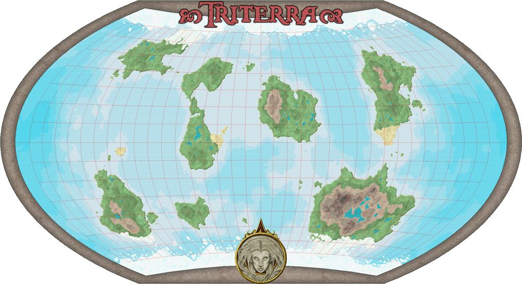
I'm working on a new map for my old campaign world, Triterra. I have a rough draft done and would love to hear some critique and ideas on what could be changed/added.
Uploaded a new version.
Thanks!
I'm working on a new map for my old campaign world, Triterra. I have a rough draft done and would love to hear some critique and ideas on what could be changed/added.
Uploaded a new version.
Thanks!


Comments
For a rough draft its rich in detail so far as well.
As a gaming person I could easily see this map in use in a campaign setting. Pretty nice.
Here are some ideas for you as requested.
If we look at climate & landmasses and how it has had an impact on earth a few ideas come to mind.
I think the Polar regions would have more impact upon the land. Think Greenland, or Canada, Alaska, Siberia where there are glaciers, ice pack, frozen ground year round. Russia has pretty drastic frozen winters where some of its shipping areas are impossible to get to unless ice breakers blaze a trail to the port. That said you have some water placed pretty near those polar regions which could be made into ice. There would be tundra type areas.
The ocean winds and sailing. How will ships sail that far? There must be islands not seen at this level of detail zoomed out. Along those lines what sort of areas do you see in the world? Jungle, Desert, etc. Where does the water come from, why is the area the way it is. Is there 1 Moon, no moons, multiple moons? They have an impact on waves and severity of weather on the oceans. For example a Trireme is fine in the Med Sea, but does not exactly sale in the Atlantic / Pacific Oceans.
Mountain ranges, Volcanoes, islands, etc. Think the Ring of Fire here on earth. You have a spot on your map that looks a bit like that. How did the landmasses get the way they are over time? Was it one super continent and the pieces broke up? Or was it several, that type of thing.
For some real weird adventuring how about the sea floor? Are there areas ripe for some weird lizard / fishman race? Is it like Earth where we have huge areas many times the size of the Grand Canyon below or is it more of a level milder ocean. That probably is a bit much but it would be interesting as you sort of have sea level contours in the map too.
What about the equatorial areas? Usually some deserts will show up someplace around the world.
Don't mean to write a book but if I'm asking and looking for input the more the better I say.
Great job on the map, look forward to seeing more!
JJ
Bigger ice caps sounds good, just not sure how much more is good. Same with the Tundra areas. Any idea to which of the latitude lines they would "normally" extend? Triterra is 24900 miles in Diam (e.g. earth size).
I had a concept of plate techtonics below the surface that does not show here, nothing exciting though, just a few lines.
Still thinking about where desarts would likely be and how big.
At this zoom level I'm not sure how much I want to comit to filling in mountain ranges and forests since they will have to match the sublevels I'll be making.
Just from looking quick online I see that the maps of earth from space you can see green, blue or tan / brownish.
Some fine tuning and your all set it looks like.
Like to see the continental maps when you do them.
Thanks for sharing
JJ
The map looks fantastic. How did you give the appearance of the continents following the curve?
Another thing to consider is buy a used copy of a world atlas book. That's what I did a few years back. Checked the clearance books and found one for ten bucks. Well worth the cost and then some.
I like the various Desert additions and think it makes sense to have covered some of the land in the north and south poles with some tundra / ice sheet.