Community Atlas - Continent J - Forlorn Archipelago
 JimP
🖼️ 280 images Departed Legend - Rest in Peace
I haven't settled on a name for these islands just yet.
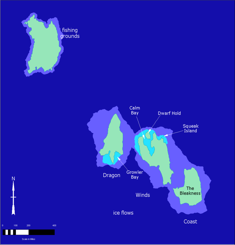
Dark blue is of course the ocean depths.
Purplish is the 'continental' shelf. Water is down to 2 miles, or 3,219km, deep.
Light blue is the shallows. Wading depth down to half a mile, or 0,805km.
I'll map more, and come up with additional names and places. Squeak Island is less than 2 miles wide and about 4 miles long. 3,014km x 7,234km
Png is 800 pixels of my original export size. Original is 1152 pixels wide.
Edit, instead of Continent, shouldn't this be islands ? Anyway, I am naming them the Forlorn Archipelago.


Comments
Feel free to add more minor islands around the coast if you want to though, it's only natural that small islands exists that didn't show up on the world map.
Edit: Name sounds good though, this is definitely an island region.
I kept to just the standard pallete.
Which bitmap fills are in just CC3Plus ? I would like to 'fix up' the islands a bit.
This map is 800 x 833 pixels, the original is 1152 x 1200.
Not sure what additional detail I can add at this level. I hesitate to add towns, villages, and rivers.
A large frozen lake could be placed on The Bleakness and Kraken Island.
Oops. Almost left out a bit of story I came up with.
Basher and Fisher cities are rivals. Fisher has a slightly larger fishing fleet. They take over the fishing grounds and Basher's fleet has to go over by the, unknown to the islanders, deep hole to fish. Sometimes something comes out of those dark depths and eats nets and the occasional fishing boat with crew.
The Princedom of Hunters are the good guys and hunt for trolls, giants, orcs, etc. The Princedom holds a bit over half of the island and the evil beings hold the rest.
For some future details... there could be sea caves and old volcano tubes that connect the 3 islands to the lower right.
Here is the updated map.
Since you are using bitmap fills for the islands, have you considered doing the same for the sea? Even if you don't find the number of different shades you require, you can always darken a section by overlaying with a polygon using the Solid 30 fill, basically giving unlimited possibilities.
This link to Sable Island with some photos will illustrate how i came up with this idea.
Map misspelled word corrected. Thanks Wyvern !
Also, "ice flows" should probably be "ice floes" as it seems an area of drift ice, whereas "flows" relates more to glaciers.
Squeak Island has lots of giant rats on it. Along with some large bats.
No, I've never heard of that dish.
I had thought of undersea tunnels connecting some of the islands in the lower right of this map, but not connecting to the one in the upper left.
What details is the group going to decide on for this map ?
Or, do we even need more details on this large scale map ?
Squeak is 11 to 14 miles.
Kraken to Justice island is 141 miles... but there could be evil towns down there. The Underdark connects lots of things.
But from Justice to The Bleakness is only 40 miles.
I'll think on it. There could be tunnels that go part way on level below the seabed. And ones that connect all of them miles down. These islands are on a continental shelf which could help with connections. I have thought about Mermen cities... but I've never used them so I'm unsure where to place them.
I was thinking of dividing up Fisher and Justice Islands... into two more areas. The known ruins is enough of a guide though for detail mappers. Also thinking about adding in climate info. The Bleakness is rather close to any arctic type areas while Fisher is closer to the temperate areas.
Overland CC3 for the style in CC3+
I agree with Quenten, you didn't waste any time putting together a living map!
Cheers,
~Dogtag
I see Fisher and Basher as more cities, but they could be fishing villages.
The Bleakness is a blasted land, unknown if my magic or weather/volcanoes. Once a thriving small nation along the lee shore, it was destroyed before the trolls arrived.
Growler Bay gets its name from the pack ice that crashes against the shore, trying to remove the impediment so it can get to the cozy home, villages, and towns inland, and smother them in Ice.
Churning Mountains... I haven't quite decided on what is going on there.
Fisher Island: humans, elves, halflings, and gnomes.
The Bleakness: other than the trolls, nothing is known.
Justice Island: humans, dwarves, elves, halflings, gnomes, orcs along the icey south shore.
Have to do things around the house, so I'll be back around tomorrow.