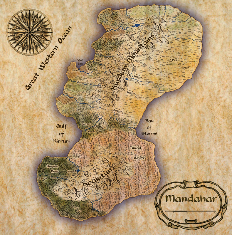
First CC Map
I've created my first map in Campaign Cartographer and while I'm pleased with the results, I have to say that the initial learning curve was agonizing. If not for the landform maps annual, I'd have written the whole thing off as a bad investment. The number one improvement needed, in my ever-humble opinion, is better manuals and tutorials. My many thanks to all of the people who have contributed to the forums, as your work and words were both inspirational and enlightening. I certainly hope to be back with more and better maps in the future.


Comments
I've been using CC for a long time, having made lots and lots of maps. This was your first one?! Even more impressive.
Wow.
Steve
I have no clue on how to create a beautiful map like yours, no idea at all. The worst of all is that I can't find tutorials online
But congrats!!
I agree with the learning curve, but once you learn what CC can really do and how to do it you end up with amazing maps like yours.
Have you used your own symbols or some methods of style-changing?
Sorry for my English
The only negative comment that I would have is that the outer glow from the continent onto the water doesn't quite fit with the style of the rest of the map.
Zerad adjusted himself in the saddle. "Muhab, sound the horn, and let it be known to the faithful that any who stop at the wadi will suffer."
This would be a good day, a day that the river Riblu would run red with Assurian blood, a day that the Assurian dogs will call Zehrad 'El Hawadi master, a day that Emir Zehrad 'El Hawadi will rule Assur.
The commander of the guard frowned slightly before answering. "At least. Maybe a few more. Five cadres of swordsmen, as well."
"Can we stop them?"
Bannir shrugged. "My men are worth two of 'El Hawadi's. They'll break on our shields. I worry about the riders, though. We don't have enough cavalry and if their riders get behind us the day is lost."
"I will direct Golob Dahr to take care of the camel riders. You and your men can do your work without fear."
Again Bannir frowned. "How can you be so certain about Golob Dahr? There are so many riders for one man, wizard or no."
Oshan Marimbi gave his old friend a smile. "Dahr has powerful reasons of his own to hate the Emir. I have little doubt that he will provide his old captor with a most enthusiastic welcome." He reached out and squeezed Bannir's shoulder. "Now come friend, we have business to do. Before the sun sets we'll see the end of that filthy desert rat."
Thanks for the feedback. I agree about the blue glow. I'll probably change it to look more hand-tinted, like the other colors.
Edelas -
The symbols are from the landform maps annual. I paint them manually, rather than using the automatic fill mode. The fill is too regular and tends to use inappropriate symbols.
General thoughts -
The map outline, rivers, and symbols were all done in CC3. The coloring and lettering was done in Photoshop. It's probably possible to do both in CC3, but I have a lot of experience in Photoshop, so for me it's faster, easier, and produces better results. The compass rose and the scroll in the lower right were hijacked from 17th century Spanish maps of the Gulf Coast. I'm pretty sure that they're out of copyright by now.
As far as making the map look good, there are two important steps that are easy to forget:
1) Think of the stories that you want to tell and build a world to tell them in. Seraphim_72's story was not all that different from what I had envisioned before I started the map. I had planned a spice route from the Amanu Naiu through Assur. With those stories in mind, I knew what terrain features I wanted.
2) Look at real world maps and see how the terrain types play against each other. If you are still in school, it doesn't hurt to take a geography class. Learn about rain shadows, lee waves, and the difference between continental and coastal climates. Try to keep scale in mind, too. Mandahar is roughly the size of California or Japan. It has room for a variety of environments.
Thanks to everyone for all of the nice comments.