

2nd map
 MatthewBertram
🖼️ 5 images Traveler
MatthewBertram
🖼️ 5 images Traveler
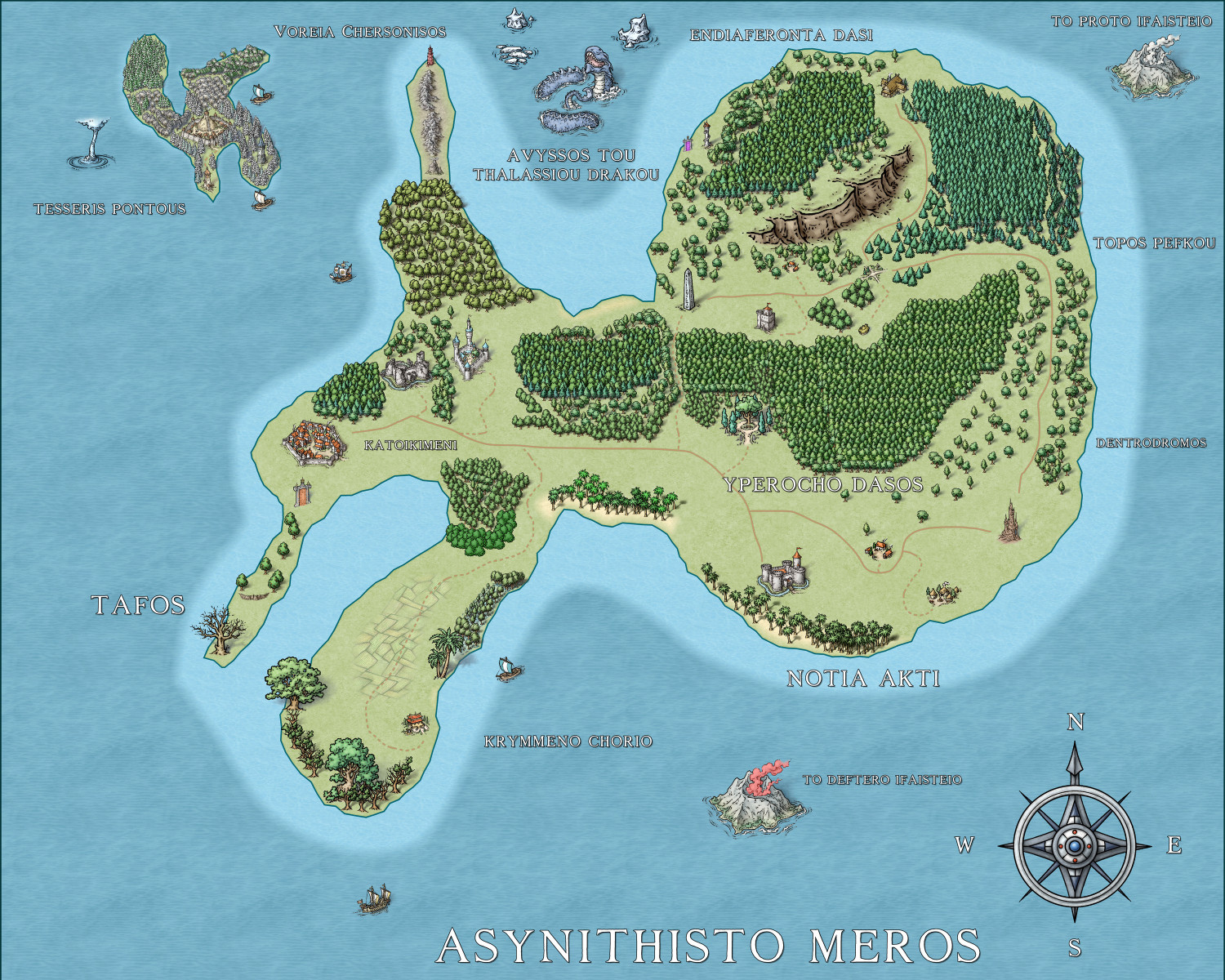
Asynithisto Meros, or as it's translated from Greek to English "Unusual Place", is my 2nd map. With 13 regions from a southern swamp-like farm area all the way to a sea dragon's domain, I tried to reach out with this one a bit more.
I definitely went more tree happy this time around. I felt that I didn't do enough the first time around and now I feel that I've done the opposite, while leaving some areas perhaps a bit too sparse. I wanted to do something a bit more mysterious, hence the teleportation gates between Tafos and Katoikimeni as well as by Avyssos Tou Thalassiou Drakou. Used different architectural structures this time around, ranging from a walled city in Katoikimeni to a few castles, towers, villages, Elven structures, an obelisk, as well as the stronghold on Tesseris Pontous. Also added some volcanos, as well as trade ships.
Very proud of this one! Will upload a file-size appropriate JPG here and then a bigger file for my own personal gallery if anyone's interested.
Errors I made/problems I encountered:
-Perhaps could have added a harbor of some sort in several areas of the map. Not kicking myself for it though, not sure how to do that just yet.
-Despite being a tree happy map, I went WAY overboard with the trees on Tesseris Pontous that it looks clumped together.
-The coastline looks too jagged for Voreia Chersonisos, maybe could have added a couple trees here and there as well.
-Should have used a different volcano for each of the Ifaisteio volcanos.
-Probably could have done with another beach or two in Notia Akti.
-Put the 'W' in the compass too far to the left (my fault, should have chosen one with them already written).


Comments
The Herwin Wielink overland style has a pier that I use a lot as a port indicator.
Like in this drawing, for example.
In this second example, I use the same image of the pier, connecting it multiple times, to imply a "larger" port.
Not sure where to find the symbols that aren't a part of the map type that I'm using.
Hit this button and will open your CC3 folder
make sure you are in Cc3 > Symbols > maps
Go to the Herwin Wielink image archive, go to the COAST subfolder and there is your pier.
So that's how you do it! Thank you!
Looks amazing btw! Great stuff!
I don't have much knowledge of the Software, but we are here to contribute.
I was looking for a video to show it, but screen grabs would have been faster. Ralf and Remy do it all the time in videos, but finding the right spot where it's shown in an hour-long video can be a challenge.