Help with snapping symbols to hex grid
Hello, I created a hex map using the Annual Hex Overland style, following the model presented in this video:
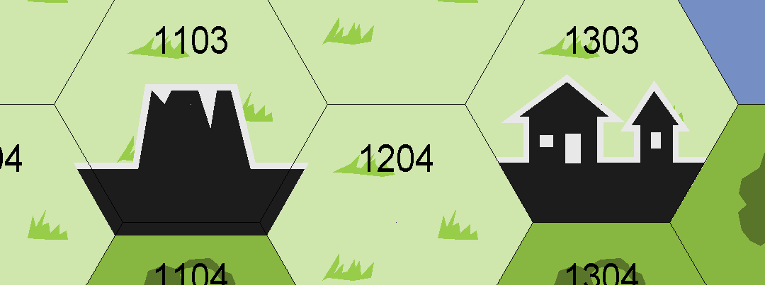
However, after saving the map and reopening it later for editing, I am now unable to get structure symbols to snap properly to the hex grid. I am attaching a screenshot to illustrate the issue. The symbol that snaps tightly to the grid is one I had added when I first created the map. The mismatching one, I tried to add after I reopened the map for editing.
I tried to play with different settings but I can't get the software to snap those symbols properly.
Any idea what might be the issue?


Comments
Looking at the way the symbol is misaligned it appears to be too big - overlapping equally on 3 sides.
Get another symbol on your crosshairs and then right click. You will see a dialog there. Click the Set Normal button and ok. I'm hoping that should give you proper alignment.
Also make sure you have a proper hex snap grid selected (Right click the Grid button in the lower right). Having the right hex grid snapping active is what triggers the automatic resizing to fit the grid. Not that if you had a symbol on your cursor when setting the snap grid, you need to pick up a new symbol from the symbol catalog to trigger the sizing.
Thank you @Monsen and @Loopysue, that helped. In the end I had to set the scale manually to the grid spacing I had selected when creating the grid (50). It seems to reset to 25 every time I reopen the file.
Edit: found the menu to set the default symbol scale...
I discovered there was a problem with symbols not working to the hex snap grid a while ago.
Following discussions elsewhere, it seems this can happen if you set the hex grid up during the initial map creation process, using the new map wizard. If you don't do that, and just use the snap grids in the map once it's been created, it should be OK. In the experiments I carried out from that linked topic, I ended up placing the location symbols by-eye alone, which was doable, though not ideal.
The hex maps I've done since haven't relied on placing features to the snap grid, so I've never gone back to find out if this works, however!