

Community Atlas submissions: the Gold Coast (Doriant) and areas within it
 Royal Scribe
🖼️ 388 images Mapmaker
Royal Scribe
🖼️ 388 images Mapmaker
I am going to use this thread to officially submit my maps for the Gold Coast region of Doriant. I will have separate Work-in-Progress threads for feedback on maps as I am working on them, and then will use this thread for the official submissions so they are easy for Remy to find. I know Remy isn't processing new submissions until the contest ends, but this will queue up my future submissions for later this fall or winter, and it also provides a home for some of the villages I want to submit for the contest.
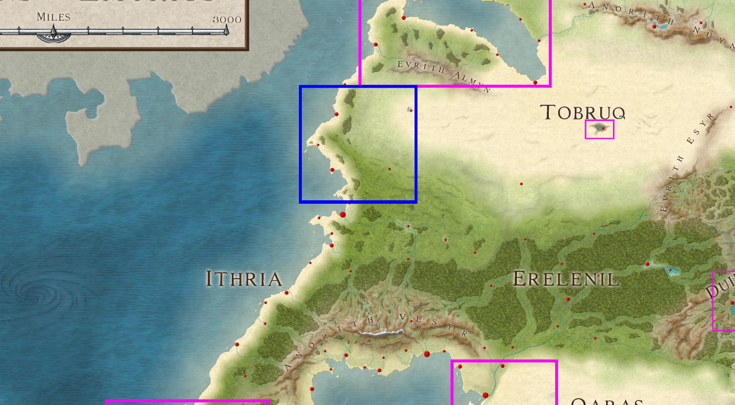
The first submission is ready! It's a 1000 x 1000 mile section on the western side of Doriant.
Here's a markup of the parent map to put it in context (the blue border represents the area I'm calling the Gold Coast.
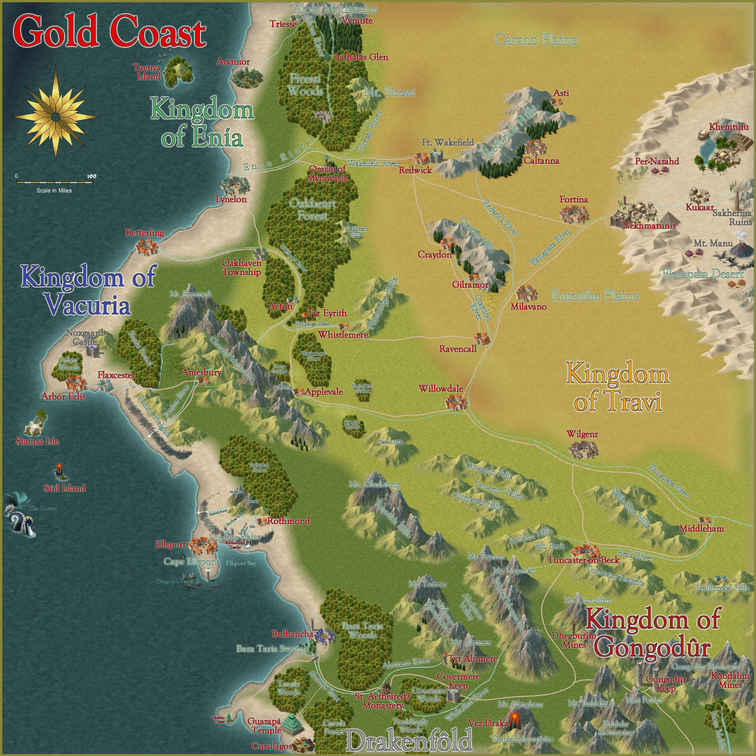
And here is the Gold Coast with all labels but without political borders shown:
Here is the FCW file, along with a PDF description and a plain text description. (I stripped out accents and special characters in the plain text file.)
Primary Style: Annual Spectrum Overland
Toggles: "Borders (Political)" sheet to turn display or hide the political borders within the region.
@Monsen, please let me know if I've messed up and need to fix anything, or if you'd prefer submissions to be handled in any other way. I have lots of other local area maps within this region that will be ready to submit soon.


Comments
I'm ready to submit this intermediate map for the Kingdom of Enía, along the northern edge of the coast for the parent map above. This map will be the parent (or possibly grandparent) for a few villages I will be submitting to the contest.
Primary Style: Mike Schley Overland
Toggles: BORDERS/POLITICAL to show/hide political borders
Here is the FCW along with a PDF of the description:
Should I do a plain text file that strips out the accent marks? Here's the text of the description (with accent marks):
The elven kingdom of Enía is the northernmost coastal kingdom in the Gold Coast region of Dórian. The human Kingdoms of Vacuria and Travi lie to the south and east, respectively. Enía is significantly smaller in both population and geographic size than its neighboring kingdoms. The kingdom’s borders are marked by the Enía River along its southern border, and the Firessí River and edge of the Firessí Woods along its eastern border.
Enía is governed by a hereditary monarch who is advised by two political bodies: the Council of Adept Mages, and the People’s Assembly. The Council of Adepts consists of those archmages and adept mages able to cast the most powerful spells. The People’s Assembly includes a hundred citizens elected throughout the realm.
Major points of interest include:
Arynnor: The capital of Enía, called the “city of glass.” Here, elves pioneered glassblowing techniques both for ornamentation and practical purposes. This includes a technique to make glass nearly as strong as steel, which has allowed the elves to safely cover their towers with brightly colored glass domes.
Sather Academy: To the north of Arynnor, Sather Academy is an institution of higher learning with academic classes of all sorts, from history to astronomy, poetry to accounting, but it is most famous for two things: its Bardic Colleges, and its Arcane Academy for the formalized study of wizardry and arcane lore.
Lynelon: The coastal city on the northern bank of the Enía River, Lynelon is a bit smaller than the Vacurian city of the same name on the southern bank.
Firessí Woods: Much of the realm is covered by a mighty forest, the Firessí Woods. The woods are home to numerous tiny elven hamlets along with a few notable features. Towards the southern edges of the Firessí Forest lies an ancient henge of standing stones, the Firessí Temple, erected to honor the elven gods. It is the holiest place in all of Enía, and the seat of power for the Archdruid of Firessí, the most powerful religious figure in the kingdom. A small village, Yréas Kôltyn, provides a home for the elves who tend to the temple and provides accommodations for the temple’s many pilgrims. To the northwest of the temple lies the Tampuwari Ruins, the haunted ruins of a people so ancient, they disappeared long before the elves moved to the area. The ruins are best to be avoided. Farther to the north, Lathalas Glen is a town built up around a monastery of the same name.
Taenya Island: The small island is home to a few small villages and hamlets of wood elves Just to the north of the island among rocky reefs, Eilân Danaäd is a harbor village of sea elves with homes both above and below the waves.
Should I do a plain text file that strips out the accent marks?
The character set in map notes only does standard ASCII characters, not the entire Unicode range, so it has certain limits what will work or not.
You can easily test yourself if anything is necessary to remove by creating a new map note in a map, paste in your text, and then open it up in the viewer (the blue window) afterwards.
Here's a plain text file with the accented/special characters replaced with the standard ASCII equivalents. I checked t as you advised and didn't see anything amiss in the blue window.
I am ready to submit the FCW for the Eknapata Desert for the Atlas, knowing that it won't be processed until after the contest ends (though it is a parent map for a village I am submitting to the contest).
Here is the FCW, along with a PDF Description and a plain text file (with accents replaced with standard ASCII characters).
I am ready to submit the Kingdom of Gongadûr area map for the Atlas. At least one village that I will be submitting to the contest will be within this region. (I have active plans for two others in this area but we'll see if time permits.)
The parent map is the Gold Coast map at the top of this thread.
Primary Style: Mike Schley Overland
Toggles: "Borders/Political" layer to turn on/off the political borders
Been out of commission with the flu the last few days, but on the mend now. I wanted to submit the Spring, Autumn, and Winter versions of my village of Arbor Hollow in case Remy finds it easier to process them at the same time as the Summer version, which was submitted as part of the Atlas contest.
Here are images, followed by the FCW files. The description is the same for each, but I will provide again here anyway.