

Importing real world map
 wintermute
🖼️ 8 images Traveler
wintermute
🖼️ 8 images Traveler
I think about using a real world map (Hong-Kong) and use some borders on the background sheet.
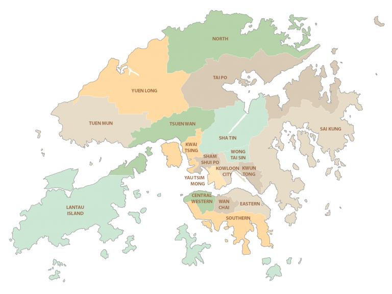
https://gisgeography.com/wp-content/uploads/2021/07/Hong-Kong-District-Map-768x576.png
It is possible to convert vectorized (I assume) imagine directly into CC3 sheets without using a drawing tool ?
Comments
It's a png file, so not vectorised.
You can import the image to an FCW file as it is and hand trace the relevant details using a drawing tool.
Arf, what I feared.
Even if I vectorize the thing (gimp or whatever), I still need to hand trace the borders ?
Some people have attempted to convert png to vector in apps like Inkscape and others to import into CC3 with variable success. Due to the differences in file formats generated by these converter apps it might be easier to trace the png in CC3 by hand, but there's no harm in trying if you really want to do that.
Just bear in mind that not all file formats work when pasted into a CC3 file.
You can use the TRACED command to trace it automatically, but you do need to make a small config file change to work around a bug in the current version.
Thanks to you both for your answers ! I will have a look at it !
I undig my own topic.
I managed to use traced, thanks !
The result is:
I only got external contours. Here is the original image:
As you can see, district are drawn. You it be possible to trace it the same way ?
Not unless you wanted to separate each of them out into an image per district and trace them that way. When you get to that amount of work it could be faster just to import the image and draw the districts by hand.
Going back to the tracing job on the outline...
The result seems a little pixelated to my eye compared with the original. This can happen if the image being traced is too low in resolution or if the edge between the opaque parts and the transparent parts are not well defined. If you want to improve on that result see if you can make the image both larger (more pixels in a bitmap editor) and more sharply defined.