

CC3+ Going back to the basics-Overland.
 Kathleen Ann Cox
Surveyor
Kathleen Ann Cox
Surveyor
Hello Folks!
I have be dabbling in Campaign Cartographer and popping in and out of here for years. Today, I gave myself a new project of re-installing my complete catalog one piece at a time, reading the guides and manuals, and making the practice maps.
It didn't take long for the first hiccup to happen.
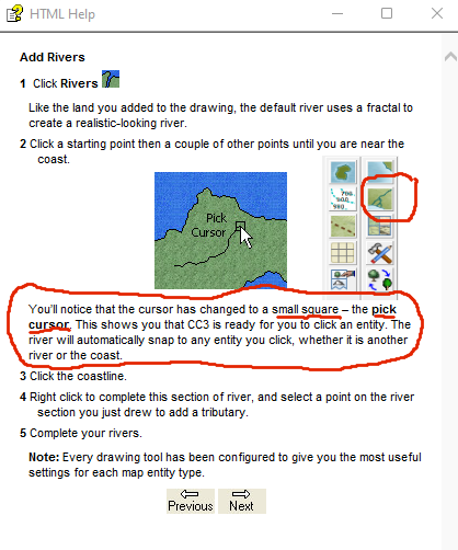
First, it looks like the river draw tool icon has changed--no problem just want to point it out for clarity.
I was working through the Quick Start Guide from CC3+, and my river drawing tool did not behave the way it was supposed to. As I clicked and made nodes, it never changed to the small square "pick cursor" no matter how many times I tried to place it near the coast.
I can't figure what step I am missing or mistake I am making. The note entry makes me think it may have something to do with the configuration of my draw tool, maybe?
Up until now, I have always used the "on" command to accomplish attaching rivers:
But it would be nice to have this happen automatically with the drawing tool.

Comments
I think the missing bit is attach, or F9. If you press the F9 key you should get the pick cursor, and the point will snap to the line you click on.
I'm not sure if the instructions are missing the F9 bit, or if things have changed in the interveining years.
Thanks Sue, F9 does indeed work. Is F9 the same as the "on" button or is it a different command?
Its the on button shortcut. I forget and call it attach, which isn't the same. Attach snaps it to the nearest node on the line you click.
Notice that this behavior can indeed be automatic with the drawing tool, and it is that behaviour the instructions was written against, but it seems that most drawing tools doesn't use it. But if you edit a drawing tool, you'll see it has a setting labeled attach mode, which can be current settings, on or off. Current setting refers to the global attach option, the button down in the lower right of the main gui. On or off is just forcing it to be always on or off. Right click the attach button in the lower right to select exactly which attach option to use, I think endpoint is the default. (The drawing tool can unfortunately not specify which attach option to use, only if it should be used or not)
Just a quick update note on this project/journey:
Here is a screenshot of the above answer.
I have moved on to the Tome of Ultimate Mapping and ran into an interesting issue. CC3+ kept crashing when I tried to trace the swamp drawing tool along the coast of the Windclaw practice tutorial, but when I created a new map it was fine. I have no idea what is wrong with the first map but I am abandoning it and starting over.
So I finished my first pass of doing the sample map "Windclaw" from the ToUM. I restarted it a few times because of different issues, but I finally got "Thumbs Up" done.
Top three things I picked up by doing the tutorial that I wasn't doing before (after using it for a very long time).
I am allowing myself to expose that CC3+ for me stands for Clueless Cartographer 3x worse than I realized plus it really pays to read manuals, do tutorials, watch videos, and read the blogs and forums.
There are still problems, but I am thrilled to be learning (or getting reminded) of what the software can do.
Now I am ready for the deep dive into Editing. I have a feeling my old brain won't be able to remember all the bells and whistles, so my goal is just to train myself to look things up. I am aiming for my memory to whisper, "I know there is a way to do that (easier) and immediately go to the reference materials.
Very nice seeing a variation of this. The original Windclaw map is from my own campaign, part of my campaign world Virana. Players are not there right now, but it still have an important role to play in the time to come.
I am really bad. I love making maps for role-playing and novels. The process of making the map inspires story in me, but I am lazy and impatient, so I try to bulldoze my way through instead of learning the program in a calm, steady, and organized manner. I am sharing my journey here to help keep myself committed to this project and to encourage some others to share how they tackled learning the program.
I myself frequently use Brute Force and Ignorance (BFI) to get through my map making!
It is nice to know I am not alone. Today I played more with fonts and stumbled upon this interesting fact (or I assume it might be a fact).
Exploding Text converts text from a font entity to a multipolied group of entities (see Tome of Ultimate Mapping p. 39 for details). I have a habit of always labeling things with two or more words on multiple lines. I expected some of the changes that were explained in the Tome (it will use status bar settings not the original), but it looks like exploding text converts line or paragraph breaks into those little square symbols. A single line of two words leaves the space as a space and is fine. Therefore, exploding text on multi-line text entities won't work? Did I guess right or am I missing something again?
Never noticed that behaviour before (don't really do that much text exploding) but yea, I think your guess is right. In text, a line break is represented using two characters, the newline character, and the carriage return character. Both of these doesn't have an actual printable representation, which those squares represents.
I guess you can always unlock groups, then erase the squares, and manually move the second half of the text down as a manual workaround after exploding.
I don't think I would have ever exploded text if I wasn't working through tutorials and I doubt I will use it much in the future. I just hit the "Text Along a Curve" issue and it was making me crazy. I started to take screenshots to post it but decided to check the forums first (a part of my re-training project to access readily available resources).
https://forum.profantasy.com/discussion/comment/104993
I am still a little confused and will have to go back and read the thread but I know Profantasy is aware of the issue.
Fractalization Frustration :)
I made my local map from my regional map (it's awful right now). Here is what happens when I fractalize the land:
It seems the fractal command is reading the land at the borders as the shape of the land and is including it, maybe. Even if this is the problem, I don't know how to fix it. I feel like I have to tell the program that the land continues beyond the border so don't frac with it, but I don't know how. I am betting I am being dense as usual.
Hey, but here is another embarrassing but fantastic thing I JUST learned.
Text is not actually written in stone tablets. I can change it with Numeric Edit. The things I did not know about the program is truly humbling since I have been playing with it on and off since at least 2014.
Oh don't worry - it always does that.
Hide everything but the landmass and use the delete node tool on the left hand toolbar to remove the extra nodes in those sides which should still be straight.
Oh, so I must have clicked along the way to the corner and then as I went up and that is what is causing it? If so, in the future I will try to rein in my click-addicted finger. :)
And yes, deleting the nodes did it.
Oh I see. I thought you meant you had used the Fractalize button on an existing coast.
When you draw the land with the fractal land drawing tool and want to have a bit that vanishes off the edge of the map, you click outside the map at the point where it vanishes, once again outside the map just before it reappears in the map, remembering to click outside the corner of every corner you pass on the way between those two points.
Sorry for the confusion. I did use the fractalize button. But I also used the fractal land tool and I thought it created nodes only when I clicked, but I guess the land draw tool will place a certain number of nodes automatically. I seem to remember that being mentioned in the tome or a manual.
The fractal land tool generates nodes along the way and displaces them randomly on either side of the line between the points you click, to create the jagged appearance. That behaviour stops if you click outside the map border because most of the land drawing tools are limited to work only within the map border. So what you get when you click outside the map is just a straight line pinned up against the edge of the map.
When you use the fractalize button it adds extra nodes between the existing ones and displaces them to create the new jigs and jags. This tool doesn't seem to create new nodes outside the map border, but it does create them inside, so you can end up with the previously straight line that was tucked neatly up against the map border suddenly developing a very large dent into the map. Thankfully, this usually only involves a few nodes, which are easy enough to delete.
Wow, very informative and good to know. To be honest, node editing has always intimidated me. In the past when something like this would happen, I would have just given up trying to use the fractal button on the land mass.
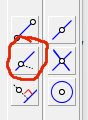
There are 3 node edit buttons. Took me some time to learn them.
I have fractalized a land mass, then I had to move the edges of the land mass back under the border. The button with the 2 arrows, and a line with a circle in the center, is it.
Node delete and node edit is what I use.
Takes trial and error to get used to them.
Trial and error is at a higher tier than my usual method. The way I dealt with node editing was just clicking around on the line hoping to find the one that will change the shape into what I wanted. It is sometimes referred to as the "buckshot" method.
So here is my River Splitting Attempt. My only real goal for the map was the gradual increase in the size of the river. I can see the change, but I wonder if it is actually too gradual, especially if the map were larger and the view is zoomed out.
It's a pretty good first attempt :)
Some of these tutorials are using things I have already picked up on my own, but I am trying to fill in the gaps of my knowledge (things I never knew and things I have forgotten). My go to method for making rivers grow was to end it, start it again using the "on" button and increasing the line width several times. Putting down the river(s) and then splitting them up into segments is SO much easier.
My journey is beginning to make me understand the terror managers feel when their workers get their training through "tribal" knowledge. Can you imagine if I got my hands on some poor newborn, innocent mapmaker and started telling them:
"Oh yeah, here is how you do that..."
Truly Terrifying!
Honestly, that is why I don't comment much on the work of others. Other then making comments like:
"Cool!" "Nice!" "I really love it!" I don't have any advice or suggestions to give to someone in the process of making a map.
And yeah, I realize our forum is probably a type of tribal knowledge, but our tribe is full of smart, experienced people as well as some great leaders. I am just that person who would probably dress in motley as fair warning to others not to ever take me too seriously.
So to practice what I have done in the tutorials I created this map to utilize some of the new Schley Symbols. I figure the reason I never fractalized my land was the issue I had with land along the map border, but now that I am beginning to actually edit the nodes (how daring of me!), I will probably fractalize more. I fixed my land and I worked with sheets and their effects as well as increasing (and decreasing) river size. I am not happy with the labels, the shape of the forests, and some of the scaling seems off, so I am going to continue to work on those things.
I think your labels and forests are good. I think some of the trees in the Inspirator's Haunt could be a tad smaller. I have appreciated you sharing your journey, and I hope it will encourage more to go through the tutorials etc
Thanks, Quenten. I shared my experience partly because I realized that I have been doing so many things the hard way for years, and I thought I could contribute to the community in my own way by confirming and endorsing the value of investing some time in using the resources that are available.
Now for my newest question:
This note in the Tome confuses me a little. I have three guesses.
Here are the some sheet effects on the Thumbs Up Map:
I added a buttonize effect in Paint Shop Pro, but the drop shadow on the scale bar and compass and the sepia coloring was done in CC3+. The good news is that merely getting used to using any tools in the program makes using other tools later easier.
Recent updates have changed this and empty sheets you may have created are not abolished any more.
What Quenten says is true, so you are also pointing out bits of the Tome that need updating - another useful thing coming out of all your hard work.
Thank you so much for your encouraging words. I was thinking I might be annoying everyone with this silly little personal project that I decided to post publicly.
Oh no, definitely not! This thread is one of the first I check each morning :)