The Sunken Temple
 Monsen
Administrator 🖼️ 82 images Cartographer
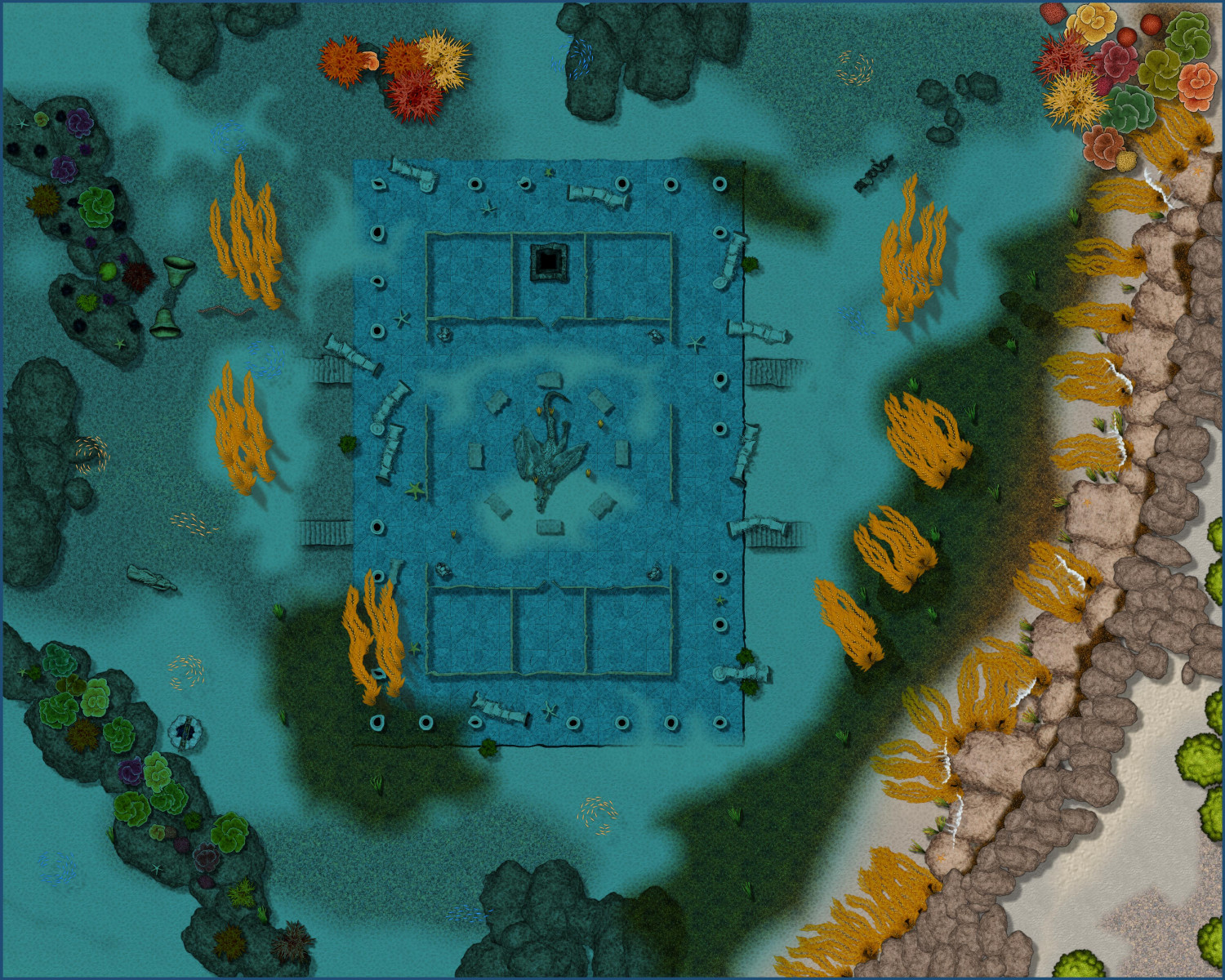
So, with visitor restrictions being relaxed a bit, it's was possible to bring the gang together once more for some roleplay. This weekend, the game took them to a sunken temple in a deep mountain lake, and what better to use for mapping the underwater scene than Sue's newest annual?
I am not completely happy with everything on this map, but it turned out quite ok thanks to Sue's excellent artwork.
I could have improved some details if I had more time, but it had to be ready for the game Friday evening, along with the map of the basement below (not shown here at this time, maybe I'll show it when my players are done with it), so time was short. It was quite good enough for the game anyways.
I could probably go in an improve it now, but since it has already been shown in the game to the players, it is kind of locked down in my eyes, so I am probably not going to modify it. But If I were to change it, I would have tried to make it look a little less bare in several areas.
Filling out outdoors areas was never my strong suit anyway though.
One major flaw with it is that it doesn't really look like the environment at a freshwater mountain lake. You don't have corals or seaweed, the vegetation is quite a bit different. But, all these things do help set the underwater mood, so I did decide that even if it wasn't completely realistic to the environment, it still served to enhance the map and reinforce the image of this being an underwater location, and I think doing it this way actually made for a better map for playing purposes.
All in all though, while it does have some flaws and some obvious mistakes, I am reasonably happy with how it turned out overall.
(Hi Res)


Comments
Now you need to find a location in the Atlas to place it - plenty of lakes to choose from.
I think you are the first person to try it out, other than the two maps done my myself and Ralf as part of the style development, Remy.
It's also perfectly demonstrates how the symbols from other styles can be mixed with the ones from MD.
I think you did really well, considering its so much larger than the example maps :)
@Quenten wrote:
Now you need to find a location in the Atlas to place it - plenty of lakes to choose from.
I am not even sure it need to go into a lake in the atlas. Honestly, it looks a bit more like a saltwater map, so I might just put it off a coast somewhere.
I put it in on Malajuri, off the coast of a small island. The map looks quite tropical, so I think this is the best fit.
I think you've said it before during a livestream -- you use a VTT with your in-person play, right?
Yes, I use MapTool.
Does everyone bring their own laptop, or do you use a monitor? I've heard it works really well -- and I imagine you can do all sorts of tricks with CC maps!
I use a projector connected to a computer running a client in player mode. It's easy enough for players to tell me where to move when we are meeting in person anyway (laser pointers are great). I turn on the view following, so the player client on the projector always show the same area as I am looking on in my client (Of course, what the player client actually shows is limited by light, vision ranges, and fog of war of course.)
But most players do bring a laptop. Easier to keep character sheets in an electronic format, and when everyone uses a shared OneNote notebook for note taking, it is easy for the players to keep common notes. So players connect to the vtt if they desire, but it isn't a requirement since we have the projector.
So different from the cardboard DM shields, everyone sitting round a big table, with handwritten character sheets, miniatures on the table with a homemade hex grid board, drinking plenty of soft drinks or coffee, and eating junk food like it was going out of style - oh, and the arguments about rules, and the squabbles between married couples, and the 'bonding' between two would-be lovers. Those were the days, my friend, i thought they'd never end!
Well, call me old fashioned. I still play around a table behind a DM screen with minis on the table and plenty of snacks :) I do print out my maps since most of the time I configure them to fit on a 24x18 or 36x24 posters - though sometimes I will put a map up on my tv if it's too large or has too many rooms to explore and keep covered on the table
If the DM was cruel (the default position), he would call out directions of the corridors and rooms, with some dimensions-and we had to draw the map ourselves. If the DM was particularly pleased with themselves - for reasons having nothing to do with DND, they would draw the map on paper as we went. Printed maps - are you kidding? This was the 1980's.
@Quenten wrote:
So different from the cardboard DM shields, everyone sitting round a big table, with handwritten character sheets, miniatures on the table with a homemade hex grid board, drinking plenty of soft drinks or coffee, and eating junk food like it was going out of style - oh, and the arguments about rules, and the squabbles between married couples, and the 'bonding' between two would-be lovers.
Well, things are not that much different. Yes, the miniatures and grid have been switched out by a VTT, and handwritten notes are now done digitally, but we still sit around the table, argue about the rules, and consume tons of snacks. And with a VTT you don't have to have the minis for everything. And it saves lots of space on the table.
If the DM was cruel (the default position), he would call out directions of the corridors and rooms, with some dimensions-and we had to draw the map ourselves. If the DM was particularly pleased with themselves - for reasons having nothing to do with DND, they would draw the map on paper as we went.
I used to be the DM that described the place and had them draw their own maps, but I realized that it took away a lot of the game. Players would spend unnecessary much time drawing, and they would frequently ask me to repeat distances (which I could hardly refuse to do, the characters were there in the middle of the dungeon and could re-check things as often as they liked).
This is why I love the VTT and projector approach. My players only see what their characters see in that moment. It saves me from describing every minute details about direction and distance, but the players see the current situation. I don't let them see back to where they have been, only the exact place they see right now. If they want a map, they can draw it, but I save a lot in explanation, and it looks so much prettier. And I can put in semi-surprises as part of the map drawing. Now, they need to actually use their eyes to spot certain things instead of me describing everything.
Not saying that the old way was better, just SO much different. I haven't played RPG's for quite a number of years ~ 15.
Well, we used to do it the 'old fashioned' way, map wise, until fairly recently. My boss had a failed side business venture and there were a couple of digital displays left over, so that then replaced our printed maps. A couple of guys who couldn't play in person then joined late in 2019, so we still had the monitor with our mini's but they joined in via Discord and Roll20 - unfortunately, now online is a neccesity in Sydney ATM.
I think this looks great. I haven't gotten into the underwater annual yet but I'm thinking about creating some underwater ruins off the coast of one of my bigger cities in my campaign world.
Here's the basement level below the underwater temple. Also flooded obviously, so I used marine dungeons for that too.
I took some liberties with this one too, for example I used lots more sea plants that would naturally grow in a place with basically no light at all. I've found that when using this style, if you want it to actually feel underwater, you may need to overdo some things that might not be completely natural.
Had a bit of fun with this place. Considering the players had to use spells to breath and move efficiently underwater, they were on a timer. Unfortunately, they are quite high level by now, so with the spells active, they were more or less able to ignore the environment. But the timer meant they couldn't just decide to rest to heal up and recover spells, and several spell slots had already been used up for the underwater support spells. Also meant that Dispel Magic suddenly became the most deadly spell in the book.
(Hi Res)
Another map for the Atlas to go with original?
Currently working on the ruiny bits for part 2...
Nice map with what is available so far, Remy :)