

Community Atlas - Dunor Valley - Ensom region
![[Deleted User]](https://secure.gravatar.com/avatar/c75d9a245b74d9c59be0999ea81ca541/?default=https%3A%2F%2Fvanillicon.com%2F92add7f8c954488718110edc4896ad39_200.png&rating=g&size=200)
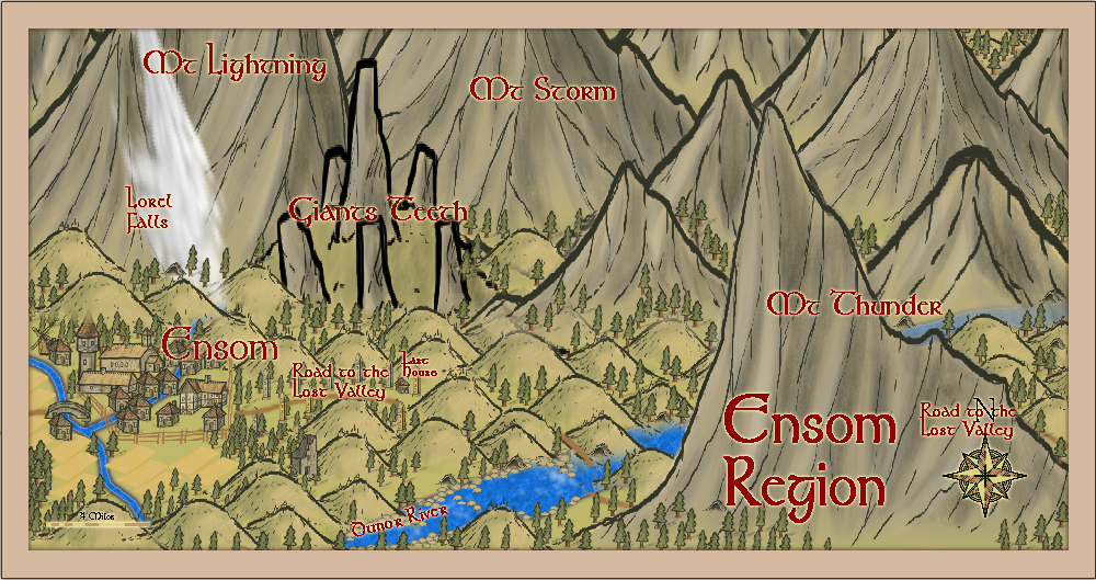
Here is the regional map for the town of Ensom. I have done Helmdal and Ensom before any of the remaining regions, because I also want to do the towns of Ensom and Helmdal. I will, though finish the whole valley. The style used, as for all of them, is Local Maps. The water fall is a distorted symbol (using asymmetric x and y values in the symbol dialogue) of a geyser turned upside down, from Spectrum overland.
I have put a revised version of the map here - to show the river Dunor, and change to destination of the road to the Lost Vally, as per the large regional map by Hadrian VI.
Comments
The map notes for the Ensom region:
Ensom Region
Ensom is a border town north-east Dunor regionin a very hilly setting, settled 130 years ago from immigrants hailing out of Helmdal and Dunor. It is a small town of ~3,000 people, led by Thane Sigurd Wolverson, a tall, brawny, fair-haired man with a long blonde beard braided into 5 plaits. He is generally easy-going, and fair-minded, but when drunk (which is not that common) he transforms into a foul-mothed aggressive barbarian spoiling for a fight.
The road east leads through the mountains to the Lost Valley, a fertile and warm region surrounded by mountains, and with plentiful waterfalls and fair woodlands- or so it is told.
Ensom is surrounded to its eastern and northern borders by three giant mountains, Mts Storm, Lightning and Thunder, with a mighty waterfall crashing down the steep slopes of Mt Lightning – the Lorel Falls. It sends fine spray over Ensom and its surrounding barley fields, when the wind is from the north-east – which thankfully is not that often. The townsfolk rather like the fine rain, and are surprised when visitors complain about it. What they do not like are the frequent thunderstorms that cause all the channels between the hills to fill with rushing streamlets.
At the entrance to the really mountainous country and at the western end of the pass to the Lost Valley, is a rambling 3-storey house, which offers meals to travellers. Appropriately, it is called the Last House – which really refers to the owner, Hermann Last.
The major feature of the region is a huge henge like structure, of five natural monoliths surrounding a huge tor – the Giant’s Teeth. Unknown to all is the fact that these are six Strom Giants turned to stone by a powerful Enchanter hundreds of years ago. Over time, the features of the giants have been weathered by the constant wet weather, so they seem like natural features to the townsfolk.
The Dunor River reaches it source in the most eastern mountains, and here there are many rapids, making any water navigation impossible. Multiple caves and hollows line its banks, filling with water in the stormy water. What lies within these has never really been investigated.
I love the story that goes along with the map. As I was reading it, it felt like I was reading the beginning of a novel. Great job. I love the idea of the Giant's Teeth. Something I may use in my future campaign.