

Community Atlas - Blackrock WIP
 jmabbott
🖼️ 39 images Mapmaker
jmabbott
🖼️ 39 images Mapmaker
Hi All,
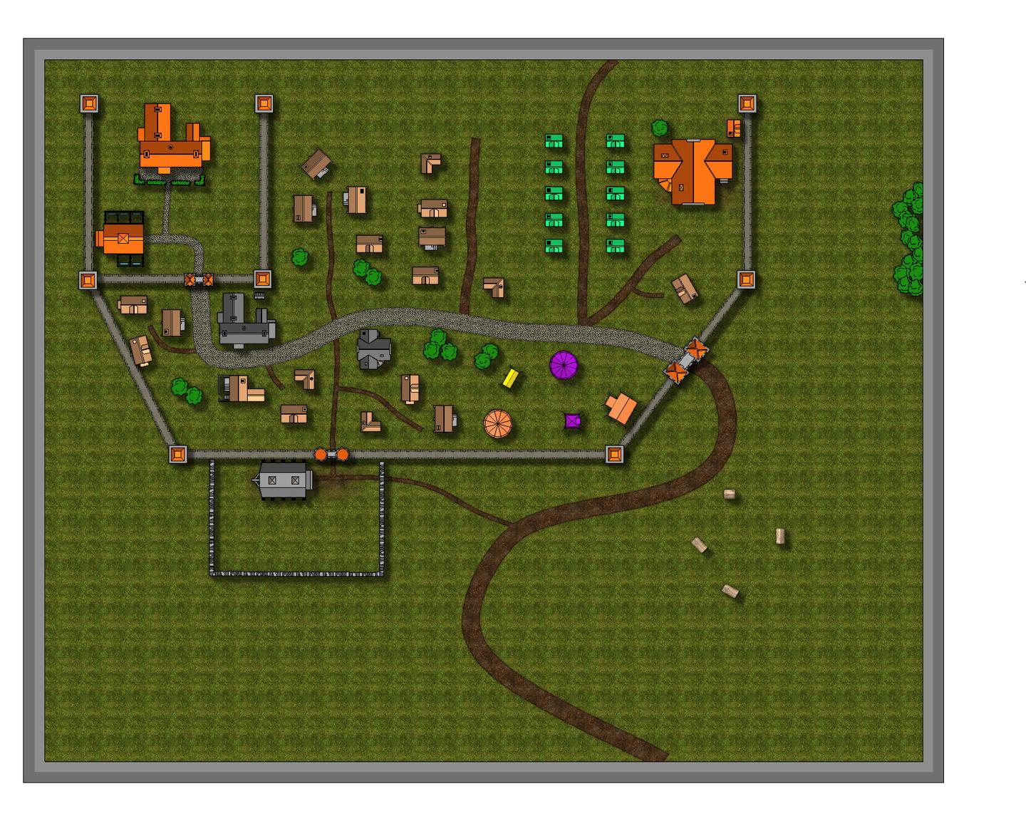
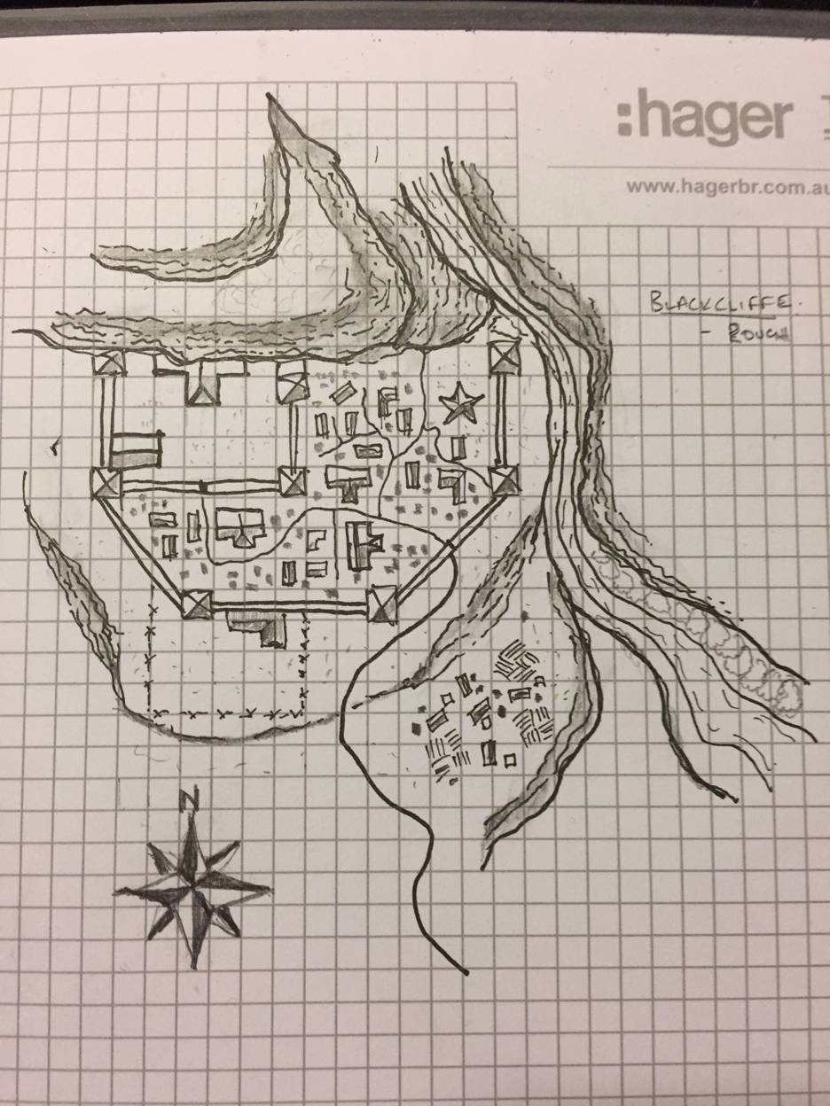
Here is my WIP for Blackrock, a mining town in the Loska region. It's about 60% done. Apart from labelling, I have to figure out how to do the elevations; it buts up against a mountain at the top of the map with a road leading into the mines and sits on a bit of a plateau with the fields lower than the township. You'll see what I mean in the sketch. The green buildings are the miners cabins. The local lord is benevolent, unfortunately the same can't be said for his son and things get much worse when he discovers something that should be left well and truly alone, which is when the fun starts...
Here is my WIP for Blackrock, a mining town in the Loska region. It's about 60% done. Apart from labelling, I have to figure out how to do the elevations; it buts up against a mountain at the top of the map with a road leading into the mines and sits on a bit of a plateau with the fields lower than the township. You'll see what I mean in the sketch. The green buildings are the miners cabins. The local lord is benevolent, unfortunately the same can't be said for his son and things get much worse when he discovers something that should be left well and truly alone, which is when the fun starts...
Comments
Decided to start again and use the Jon Robert's style with Sue's wonderful cliffs. Here is where I'm up to at the moment.
C & C welcome, and in fact encouraged!
Hi Folks,
Here is an update. I've been mixing symbol catalogs; mostly all Jon Robert's except notable buildings, arena, cemetery and wharf and Ryecroft for the hedgerows.
Any suggestions, comments and critiques are welcome as this is my first non watabou city (and cities are definitely not my forte...).
Cheers,
It's looking pretty cool, Jim :)
I think you might have an unexpected glow effect, or something similar set on the sheet with the second level of grass on it. That would be what is causing that darker line between the different levels of grass. If you haven't got anything like that I would be interested in seeing what you do have on that sheet.
@Loopysue Do you mean where I have those lines extending from where the 'cliffs' end on the lower sections? I haven't checked that in awhile, perhaps I've got the background fill on the wrong sheet, I'm pretty sure there's an Edge Fade effect, I don't think there are any others. If I can't figure it out when I get home, I'll post the .FCW file once I've done the below. I'm sure you'll be able to point out how to fix it pretty easily, it's probably something ridiculously simple.
Speaking of the fill, I need to change its scale. It is so glaringly obvious it's a tile pattern...
I'm not happy with the fields either, need to work something else out for them, they just look, I dunno, odd, not like real fields at all. Any suggestions? I might re-visit Ralf's live mapping video on the Jon Roberts City style, I can't recall if there were any fields shown in that... Maybe I'll use trees and hedgerows to 'outline' the fields and then just fill them with the terrain tools... Once I get something I'm happy with there, I'll add some more to the east side of the road in the gap between the cliffs along with some hatched roof houses.
The area west of the road I'm thinking will be forest with the Key on top. I'll probably put some forest on the higher levels as well. Not sure whether to use the Jon Roberts overland forest fills and trees or use the Mike Schley symbols. Perhaps it's a good excuse to learn the symbols in area with the exclude command (for the road).
I also need to extend the road south off the map, and maybe put a couple of houses there for the dock workers.
Put a compass rose and scale bar, probably in the lower right corner, label the map and then call it done!
Ok. I'm not sure I will have time to look at the FCW, where I'm up to my eyeballs in Japanese structures in Sketchup right now, but I'm pretty sure that even with just a few more weeks experience you will probably find it yourself anyway.
As for the scale of the fill - maybe. The thing about fills is that if you scale them up too much they pixelate, so it very much depends on how large you want to print your map. There are two ways of disguising the redundancy (which is what we call it when a seamless tile starts to generate that kind of noticeable pattern). You can either put a lot more in the map so that not enough of the background shows through for the pattern to be visible (you will have some idea of how that works by looking at the area of the settlement). The other way is only necessary if you don't intend to put anything at all in the rest of the grassy area, and involves creating irregular patches of a very similar coloured texture on another sheet above the grass that are themselves not large enough to have the problem, but which cover one in three or four of the more noticeable parts of the pattern where they appear in a line or column without interruption.
Ok. I'm not sure I will have time to look at the FCW, where I'm up to my eyeballs in Japanese structures in Sketchup right now, but I'm pretty sure that even with just a few more weeks experience you will probably find it yourself anyway.
No sweat Sue. As you say, I'm sure I'll figure it out. And if I can't, there are a quite a few geniuses lurking around here who would no doubt be able to offer a solution if I'm really stuck. If I remember correctly, I did try another terrain fill that I wasn't particularly keen on, I think it was a grass texture or something, that worked. This particular fill is a background fill so it's probably to do with sheet ordering or something silly like that.
Ok. I tried another fill over those lines and it works but I wasn't happy with it, so I've left them for the moment.
I'm happier with the fields but still not 100% satisfied.
I played around with bringing in the forest fill from the Jon Roberts overland style and no matter how I scaled it, it looked rubbish. Then I played around with Symbols in Area (Exclude) and I must have had the symbol size too small, so I'll try that again with larger symbols.
In a nutshell, all I accomplished in about 2.5 hours was the fields and adding the road and changing the main road into the town and mine. I suppose for 2 hours of that I was pretending to be Alexander Bell and figuring out what won't work... Here's where I'm at at the moment.
That's quite a lot of work for the time - especially if you are trying to do stuff you haven't done before :)
There is an awful lot of space involved in this map that in the real world would be totally covered with detail almost as dense as the detail of the city itself. There would be a network of smaller roads and tracks with hamlets and farms along them, and the rest of the land would be covered in fields, woods and moorland. A city needs a network of satellite settlements to provide it with food and other produce. Presumably there will be a lot more than just a few bags of grain and the odd cabbage being sold in the market place. The fields you have done are good, but they wouldn't provide everything the citizens of Blackrock need for a healthy and varied diet - or enough of it by far. I think they would be killing each other for flour to make bread only a month after the grain harvest was done.
There are lots of other land uses besides woodland and fields. Have you thought about mills, cemeteries, or landmarks like ruins?
I sometimes add a sheet called SKETCH to the top of the map that can be deleted when the map is done, and I draw on it in white with the freehand drawing tool the approximate position of satellite settlements, roads and field systems etc. This makes it easier to fill in the area with the required amount of detail without having to entirely re-imagine everything every time I've finished a single field or copse before I do the next field or copse. I draw the manmade stuff first, and then fill in the gaps with fields and woods as appropriate.
Title's, scale bars and compasses also help, and it is sometimes easier to pick a spot for these before it gets too crowded with detail so you don't end up covering a bit you are proud of with the title, or try to squish the title into the corner to avoid it.
The Symbols in Area tools use the default symbol scale, which is set in the Drawing Presets dialog here:
I would make a note of what the scale is before you change it, so that you can go back to the default when you are done.
Mapping can be slow when you are learning. And that is exactly the point. You might not have got a lot done on the map, but you did a lot of learning that will help you be much faster next time you are doing a city. That is nothing to be scoffed at - especially if you are aiming to do commissions one day, where time is of the essence and could make or break your bid if it is only one among many.
If you upload your FCW I think you might find that several people will look at it, and you will get a nice cluster of suggestions to pick little gems from and learn even more.
Thanks Sue,
That's a great idea about the 'sketch sheet'. Also about considering demographics and food supplies as well. I guess, looking at the number of dwellings with a few extra to be added in for support workers; i.e more farms and a couple of extra houses for the dock workers, the population of the immediate town will probably be somewhere around 350-450 people.
There is a small cemetery behind the church but a postern gate could see that extended to just outside the city walls. Those buried within are the nobles and wealthier merchants, while outside is used for the common folk.
The plan was to have the stretch between the 2 lower cliffs given over to agriculture. The bottom right is where I'll likely put the compass rose (a custom symbol, nothing overly fancy, that also serves as my signature) and scale bar. The lower left portion is where the map key will go so while it needs something, that something does not need to be elaborate as it will be covered.
My intention is to do ALL my maps to a publishable standard regardless of whether or not they are commissions as I will most likely use them for things I self-publish. It's a matter of picking up the pace so that when I do have commissions to work on the hourly rate equates to something more reasonable than a cappucinno! I think CC3+, even at my stage of proficiency, is way faster than hand drawing in Ps; I knocked up a simple floor plan as an example for an indie publisher in a little over 45 minutes.
Oh go on, then.
My head is fizzing with too much Sketchup right now.
Do you want me to look at that FCW for you to sort out that edge on the grass?
Thanks Sue, for all your suggestions and help. I really appreciate it given your looming deadline for Spectrum 2!
I'll do a bit more and next time I post an update, I'll also post the FCW file, irrespective of whether or not I've fixed those pesky edges. I think the other terrain fills will work better as they're not 'background' fills...
Hi All,
Finally making progress on this map. And I figured out waht the issue was with the cliff lines showing through, my grass cover was too low in the sheet order!
I reckon it's about done, perhaps just add a scale bar.
Is there anyway to edit the Index to remove the grid references or will that stuff up the hyperlink?
It looks much better now you have sorted the grass out :)
How would grid references be related to hyperlinks?
(that's just a question because I'm confused by your question)
How would grid references be related to hyperlinks?
@Loopysue Hi Sue,
For whatever reason, I can't remember why now, I had the grid set up at 25 metres, so when I created the index for the Key the grid labels are off the map. I tried to edit the text block to remove the grid eferences but it appears to be a hyperlink and the Change Properties command won't let me edit it. I asked the question because I thought the reference might be used as part of the hyperlink. Now, that you've questioned it (and I've had some sleep, it was 1/2 past midnight here when I posted!) I realise that the grid reference probably has nothing o do with it...the hyperlink that is.
LOL! I'm now seriously confused.
But I've never used one of those fancy key things before ;)
All it does is zoom into the location, I'm guessing by a hyperlink. I read the CD3 Essentials and now know how to edit it but I'm going to re-do it, as it's for the Atlas so I want it to be right.
You could try it with a test copy of the file?
@Loopysue All good Sue. I decided to just edit it.
I don't know what Crossover actually did but running CC3+ on my Mac natively, apart from text being a pain and the function keys not working (perhaps there is a setting on the Mac I could've change for that...), was much faster than running it in the Windows 10PRO partition I created. Redraws with sheet effects on take bloody ages.
I can really understand why some people don't like technology. It can be extremely frustrating.
Did you install the apple bootcamp drivers for windows? I know there are some performance issues if you don't, because Windows doesn't come with mac support out of the box.
@Monsen As far as I'm aware the Bootcamp assistant does that as part of the set up process, so I think the answer to that is yes.
Also, this is just about finished. I deleted my submission post (I know you're not accepting submissions Remy but this is nearly done) as I noticed there is still the cliff top showing through where it shouldn't on middle cliff level.
So this would be the Better Day At Blackrock, presumably ?
Indeed @Wyvern, indeed. I changed the redraw speed in the view menu and while it's still a little slow, it is certainly an improvement!
I fixed that little section in the middle and am trying to decide whether or not to make the arena bigger and change the dock to just have 1 larger boat dock... what do you folk think?
For the size of the Arena, not sure it will help necessarily, but the Greek and Roman stadion/stadium, also known in English as the stade, unit of length was around 180-185 metres in length (there were variants, and some modern estimates have varied still further from this). That might be a way to go, though it would be likely the inner circumference, not the actual length of the construction in an oval form. It really depends what goes on there as to how large it should be.
The River Docks is another in the "length of string" debates, as it depends what the river is used for and by what proportion of the populace, whether it's used for exports and imports (and what of, type and quantities), does a ferry run from here to other places (such as even across the river), etc., etc. To my eye, for a river of this size, the three docks now seem probably too few, but more information would be needed for a more definitive answer, I think.