

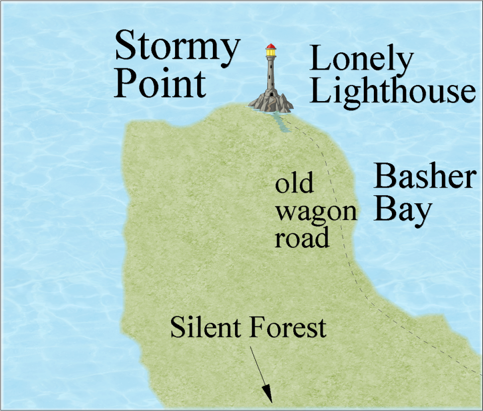
Community Atlas: Lonely Lighthouse, Stormy Point, Basher Bay
 JimP
🖼️ 280 images Departed Legend - Rest in Peace
JimP
🖼️ 280 images Departed Legend - Rest in Peace
I redid the map border and deleted the bits not needed from a previous larger map.
This really needs something else. A wreck in the shallows near the point ? A reef or two ?
Effects run, but that doesn't look correct either.
This really needs something else. A wreck in the shallows near the point ? A reef or two ?
Effects run, but that doesn't look correct either.
Comments
Could probably consider adding a very tiny island or two off the coast, and maybe add features such as a small ruin (even a larger ruin probably wouldn't have turned up on higher level zooms unless it was significant), a things like small hamlets or farmsteads, maybe a cave and/or a mine, etc...
Last night I thought of a sinkhole above the area where the word 'Silent' is on the map.
I'm still getting used to the mid-range maps.
If you add more details the size of the labels could come down some?
Would you like some tea ? It will keep the chills away. Tea is good for ye. Have Some Tea !"
As he fades away in the gathering sunlight.
And the cliffs don't quite match the shoreline. Michael Schley symbols. I'll have to work on the effects.
The evergreens are shrunken from the wind and the oaks are all gone. Their trunks slowly rotting away.
As an alternative, you might try a black Glow, with parameters adjusted so it looks more like a simple black outline. That could marry things up a little more with the cliffs symbol, for instance. Or you could just draw a black outline around the coast either freehand, or perhaps easier, by copying the land polygon to a different sheet (above the LAND sheet in the stack, of course!), and then converting the new polygon to a solid fill with an appropriate line width for a black outline (or another colour if black seems too harsh).
I'd be inclined to hold off on too much Blur at this close level of mapping scale. This is of a level where modern maps show every individual building, fence and hedge line, even things like individual boulders if they're large enough. I'm not suggesting that's needed here, just that features can be much more exactly defined on maps of this type.
I have even heard other people say 'Now, thats a really big boulder !'.
I think they were looking at an outcrop, but it could have been one of several 'size of a house' boulders nearby to.
Forlorn Archipelago, Basher Bay, The Lonely Lighthouse on Fisher Island
Name: JimP
Contact details: Profantasy forums http://crestofastar.drivein-jim.net/
Map Description: A lighthouse on Stormy Point. Not much out here.
The tree symbols represent an area of trees, not an actual tree count.
The map is 5.3 miles by 4.5 miles.
Style used is CC3+ Overland, template is Overland Mike Schley.
Bitmap fills and colors used:
Peninnsula land is Land_MS
water is Sea_MS
color 100 for the green in the compass
For the var-color hamlets, Desert_MS
Font is Baskerville Old Face
Symbols:
Mike Schley Overland
The old wagon road is how the light house is supplied with food and water. Two small hamlets provide shelter along the way for the wagoneers.
The sinkhole has been known to move. Adventurers that go to look into it, disappear.
The Weeping Sands are the remains of the Dread Cliffs breakaway.
Ruins: Spotted Elm and Bashed. Two hamlets that met a bad end not long after the sinkhole first showed up.
The Wandering Sands is one reason for the lighthouse. They move about in the shallows. No one knows why.
A few small areas of pine trees. The oaks are all dead and dieing.
There is someone keeping the Lonely Lighthouse in use, but there is a ghost as well.
The old light house keeper tella ya, "This point was once a thriving area of small hamlets of people. But the sinkhole showed up and swallowed a manor house. The land gave way and formed yon cliffs and sands. You can sometimes hear the wailing of those who were drowned there.
Would you like some tea ? It will keep the chills away. Tea is good for ye. Have Some Tea !"
As he fades away in the gathering sunlight.
Thanks for contributing.