

Can't get mapsize right

Hello all,
I am having an issue in getting a map to the right scale. I prepared a campaign area in hexographer as a hexmap for me to use. I now want to turn that hexmap into a player handout ready map in CC3. I am importing the image into a new map. One hex should resemble 6 miles, so I calculated the CC3 map size as hexes*6 for width and height. Alas that is not working. The scalebar keeps showing 20 miles for 5 hexes, that should be 30. It is probably a newb issue but I just can not figure it out since 1,5 hours. I tried raising the mapsize by 1/3 but that changes nothing when I put in the hexmap again, as the ratio width x length stays the same. I suck at math and have a hard time grasping what I am missing. The Hexmap export is 1452x1323 pixels 72ppi. Hex size is 40x30 hexes 1 hex 6 miles. By simple calculation it would be 240x180 in CC3 but the format is not working out as the hexmap is almost square and CC3 it is definitely not. I guess the hexmap is the culprit as a hex can not be translated that simply? Anyone able to help? Thank you in advance!
I am having an issue in getting a map to the right scale. I prepared a campaign area in hexographer as a hexmap for me to use. I now want to turn that hexmap into a player handout ready map in CC3. I am importing the image into a new map. One hex should resemble 6 miles, so I calculated the CC3 map size as hexes*6 for width and height. Alas that is not working. The scalebar keeps showing 20 miles for 5 hexes, that should be 30. It is probably a newb issue but I just can not figure it out since 1,5 hours. I tried raising the mapsize by 1/3 but that changes nothing when I put in the hexmap again, as the ratio width x length stays the same. I suck at math and have a hard time grasping what I am missing. The Hexmap export is 1452x1323 pixels 72ppi. Hex size is 40x30 hexes 1 hex 6 miles. By simple calculation it would be 240x180 in CC3 but the format is not working out as the hexmap is almost square and CC3 it is definitely not. I guess the hexmap is the culprit as a hex can not be translated that simply? Anyone able to help? Thank you in advance!
Comments
What you need to remember is that hexes are not as wide as they are tall. A hex that is 6 miles tall, is about 6.928 miles at its widest point, and 3.464 miles at its most narrow point (These lengths were measured in CC3 by just creating a 6' hex grid and using the distance tool on it). Note that I don't know which dimension of your hexes is meant to be 6 miles, I just used the height as an example to show how it will vary.
Furthermore, the hex pattern complicates things. Your hexes are horizontal, so when measuring straight north or south, it is easy since the hexes are nicely stacked on top of each other, but notice what happens when you go straight east or west. In this case, if you start in the middle of a hex, you will measure along the widest point of the first hex, then the narrowest point of the second hex, the widest of the third hex, and so on. So to get the proper width to use for calculations, you will need to use the average of these two widths. Again, I am assuming that it is the height of your hexes that is 6 miles, so then we get that the average width is (6.928+3.464)/2 = 5.196.
Using that value to calculate the map size, we get (40*5.196)x(30x6) = 208x180 as the map dimension. The scale bar should then display 10.392 miles from the leftmost point on one "wide" hex to the leftmost point of the next "wide" hex". Remember that when measuring along the east-west axis, you always need to measure the hexes in twos, because of the alternating pattern. Never measure across a space of 5 hexes when you are trying to calculate scale and hex sizes.
Obviously, if 6 is meant to be the hex width instead of height, you need to redo all the calculation with the proper values.
The hexes are 6 miles wide. Using this assumption I measured Hex size in pixels first. Thinnest end is 24 Pixels widest part 48 pixels and it is 42 pixels high. Calculating with the assumption that the widest 48 pixels are 6 miles gives me a height of 5,25 miles for 42 pixels and the thinnest part is 3 miles for 24 pixels. If I understood correctly I calculate (6+3)/2=4,5.
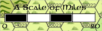
So my map needs to be (30*5,25)x( 40*4,5) 158*180. And of course this does not work right either *sigh* The Scale bar still shows a size for 20 miles that would be around 36. I measured it with the distance tool. I did this with all the hexes too. The distances measured in the hexes fit it is just the Scale bar that is wrong! No wonder I can´t get it to measure up. What can I do now? It is the Overland BW style.
If the scale bar itself is the wrong size when you measure it with the distance tool, delete it and insert a new one. You can find the scale bar by clicking the "Symbols in Map" button on the top of the symbol catalog. Make sure when you know your current symbol scale when you place it. If placed at a symbol scale of 1, the scale bar for this style is 200 miles long. Multiply 200 with whatever you are using as the current symbol scale.
Back about 1982 I was still using 5mm hexagon paper to make my outdoor maps. Well, not many home computers back then.
I had a paper, or card stock, template for 5mm hex paper. It was marked so I could just hold it on the paper and read off the distances for height, width, and diagonal paths on the 5mm hexes so I could quickly detertmine distancfes at that scale.
It was marked for different milages of 5mm hexes on the paper.
I realize the distance commmand works, but this would be good for printouts as well.