

Community Atlas: Temple of Nidag, Stormwatch, Emerald Crown Forest, Alarius
 Wyvern
🖼️ 291 images Cartographer
Wyvern
🖼️ 291 images Cartographer
For the next map in my ongoing Atlas project, I thought it might be interesting to try another work-in-progress topic, to show some of the developments as they happened along the way. It's been a while since I last tried this, and I do tend to forget to record progress while mapping, but we'll see how it goes! The initial posts below, over the coming days, will outline what's happened to get this map underway during the last couple of months, and only the subsequent notes will start to become rather more immediate.
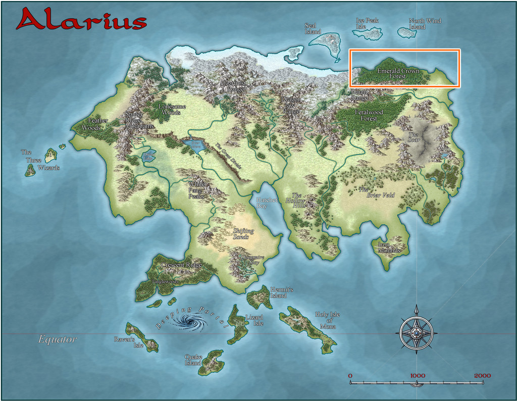
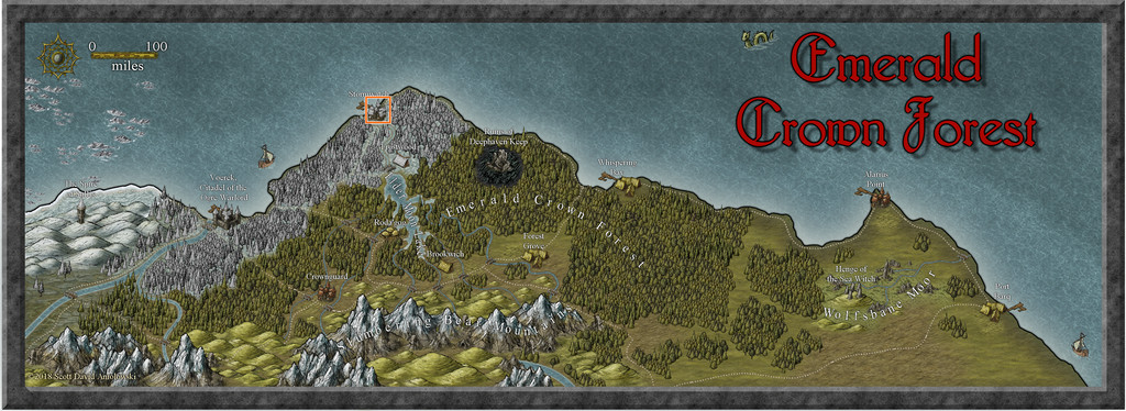
Said map was intended for somewhere in the Emerald Crown Forest region of northeastern Alarius, here:
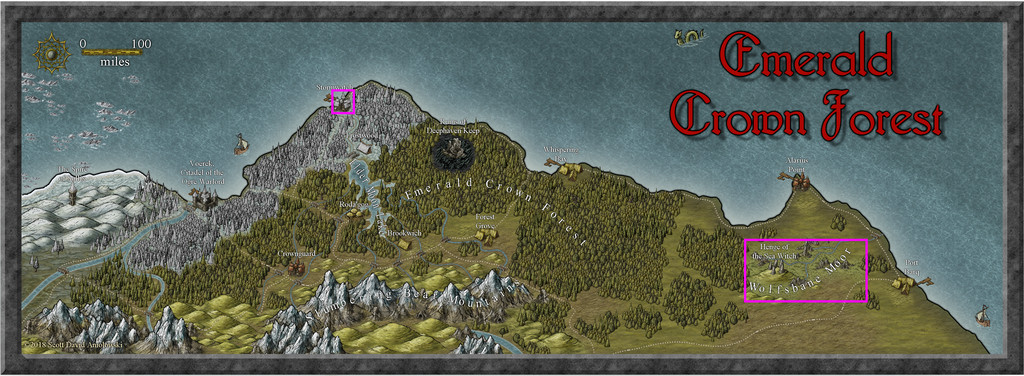
Zooming-in to the next map already in the Atlas, there were a couple of additional places already mapped (highlighted in pink), along with some equally intriguing unmapped spots:
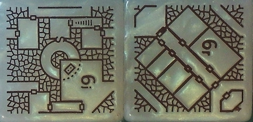
As usual, the development of each new map in this project is an organic process, in that while thinking about where the map's to go, I'm also looking at the dungeon design, and identifying ideas for what its contents and purpose might be. In this case, the design was from two Inkwell Ideas Dungeonmorph Dice in the Trailblazer set:
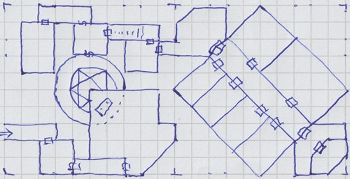
These translated into my hand-scrawled version, with the unconnected/extraneous passages and areas either removed or adapted, thus:
Looking through the Inkwell book that accompanies the dice for this pair of designs, the 6i one is from the Incantations/Magic Areas die, whose main-idea notes suggested this to be a temple masquerading as for a good/neutral deity, but which was actually for another less pleasant one - so that altar above the circular room drops victims down into it, for use in summoning an avatar of the deity, for instance.
The 6r die's main notes (for Rooms/General Areas), proposed it as part of the private quarters for some royalty, with a kitchen, dining room, and guards, while one of the alternative suggestions was for it to be an inn, possibly one with several vertical levels. In combination, these suggested a temple complex (replacing royalty with priests and inner-cabal followers), partly above ground, partly below. That suggested a larger population would be needed to both support and conceal such a place, as well as to provide victims for use in the summoning chamber.
Turning then to a couple of further books for inspiration, the "Tome of Adventure Design", and the very recently-released "Nomicon", both published by Mythmere Games, provided Maleng, Herald of the Seasons as the beneficent nature deity for the temple, with the congregation ostensibly calling themselves The Fellowship of Maleng, although they're really The Fellowship of Nidag, The Blind Slayer (the deity who's not so pleasant).
Looking at settlements in the Emerald Crown Forest area after this naturally pushed my thoughts towards the larger towns, and likely towards those on the coast, as probably having sizeable itinerant populations, where people chosen as victims would be less missed. Which eventually brought me to the pre-mapped town of Stormwatch:
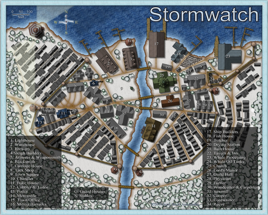
It's probably not hard to see what drew me here - there are lots of anonymous groups of houses of the right size and rough orientation to fit the dungeon dice designs quite well. Finally, I picked a spot on the eastern edge of the map, outside the town walls, here:
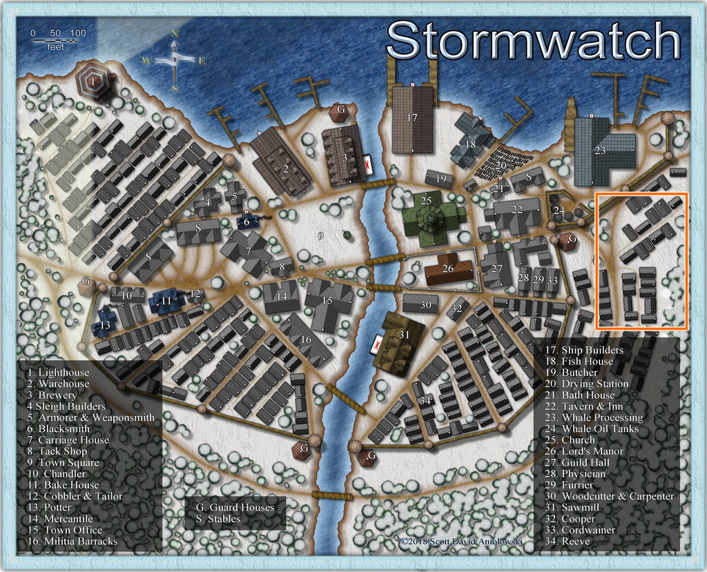
At which point we discover I was missing a few small symbols (probably from the free, non-ProFantasy, sets usable in the Atlas) - for the inn signs, chimneys and waterwheels - hence the red Xs in places (the previous shot of Stormwatch was taken from the hi-res Atlas version).
Choosing that area wasn't straightforward, however, because a swift test-trial of my hand-drawn dice design showed the fit wasn't going to be exact, either from the placement and sizes of the various buildings, or the angle between the two main parts of the design. This wasn't unexpected, and after checking several potential alternatives, the orange rectangle on the image just above was picked as the closer fit. Even then, that area wasn't properly defined at this point.
I narrowed the spot down by setting-up a basic line drawing in CC3+, where I could compare the exact shapes, sizes and orientations of the Stormwatch buildings with the dice design draft map. This began by extracting those forms from the Stormwatch map thus:
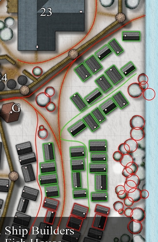
The building outlines were generated more or less automatically, by simply copying the buildings to a new sheet and layer, and changing their properties (possible only because they were originally created using the CD3 house-drawing tool), while the tree circles and road lines were all hand-drawn. The two colours are because the original test-fitting was done just with the green-outlined buildings, and took several attempts. The red outlining was to make sure all the features in the final rectangular map area would be covered too, once the final "green" selection was made. Next time, pinning-down that rectangle.


Comments
With testing completed, the next stage could begin. My original thought was to use the Pär Lindström Horror House Annual mapping style to fit the overall unsettling theme, and because I thought a simpler drawing style would be interesting to use here. Ultimately, this was changed, but this was where I began. First, the hand-drawn dice design was imported:
Then a copied version of the outlinings plus the town wall segment was pasted onto a second BITMAP Sheet, whose placement was adjusted until it approximated to a fit over the dice design:
This view shows the extent of the mapped zone, and how far beyond it other items had been picked to ensure full coverage of the key area. It also indicates that the dice design barely fits the edges of any of the structures from Stormwatch. However, it also finally allowed the choice of area to be shown on the full Stormwatch map, by copying and pasting an amended version of the map border rectangle over to the Stormwatch map (as in the penultimate image from my first post here).
With this complete, I then drew an outline version of the dungeon design's layout, amended to fit the buildings better (at least as far as the nearer- and above-surface parts of the maps were concerned):
That was about the point I realised the surface map (or maybe maps) needed to be drawn in a different style, because the Horror House one doesn't have any vegetation symbols. While some could have been re-used from others, I thought it preferable to stick with a single style, if possible. Which turned out to be the Naomi Van Doren Fantasy Floorplans one. While not monochrome, it is a nice, fairly clean-drawn style, with a limited colour palette, which seemed appropriate for this high-northern (Stormwatch is at about 58°N latitude), somewhat creepy, setting. As we'll see next time.
[Had it been available when I started drawing this map last month, I might have been tempted to make use of Ralf's new Hand-drawn Dungeon Annual style. Actually, it might match quite well with Naomi's style, so you never know...😊]
With the style selected, it was time to copy over the linear elements to a new map, after a few further minor changes (mostly to avoid copying the symbols for the town wall again):
The building walls have already been changed closer to the new map style, although without any sheet effects on at this point. The dungeon design lines have been changed to blue as well. Several copies of this CC3+ drawing were saved, in case of later problems, and so the above and below ground map designs would match.
Next, the roads, town wall and main vegetation were all added for the surface map:
The background bitmap fill has been changed too, as the roads were getting a little lost in the earlier dirt brown default fill. Effects have been tweaked here to outline the pathways better, although the trees and bushes still need a bit more work.
Now, the building outlines have been switched to the WALLS sheet, and the first pine floors added (using angle-by-edge on the flooring polygons, and adjusting the shading's pitch and angle to tone-down the wood-plank colouring, although this felt too dark and similar to the surface cover, which meant further experimentation with several aspects of that pine plank fill to reach this stage:
Still not 100% sure about the floor colouring, but I can see what's happening in the buildings now at least (particularly with the BITMAP sheet outlines all hidden). The vegetation has been adjusted by adding a further TREES sheet, and moving some of the taller trees onto it. All still subject to further tweaking, of course, though the tree cover looks less 2D now, at least.
Next began a trickier stage (given virtually none of the mapped wall lines work with the "Ortho" setting), the process of showing what the buildings contain, and how they link to the subterranean features. New floor textures (and a tweaked pine floor one too), wall-lines, doors, windows, stairs, etc., were added, in a limited section only at this stage, which gets us up to date with progress on this map:
The BITMAP lines are back, so I don't start fitting the stairs and entryways to the wrong properties, (in theory). The two buildings done so far are the main public access points to the underground temple, and as you can see, I've already taken slight liberties with the original Stormwatch map, by connecting two of the surface buildings to better work as such. Lots more to do, however, not least the fact I'd forgotten to copy over where the chimneys are before starting these interiors, so there may be even more tweaking by next time!
Returning to the Stormwatch map, I copied the positions of the rooftop chimneys to a new BITMAP sheet in the Nidag Temple Surface map, so they'd appear above the wall lines, using simple purple squares:
Since these only illustrate the rooftop flue outlets, the actual locations of the internal fireplaces can be a little different to this, and of course two fireplaces might even use the same flue, so allowing for some flexibility. Zooming-in to just the two buildings with the internal walls shows how I opted to set-up the fireplaces in these, based on where the purple squares were:
This also provides a clearer view of exactly how the interiors were being set-up. All very basic still, with just the essential main structural elements.
My initial aim with the interiors was to lay out just the access-points for the lower level dungeon design, as the next two snapshots illustrate:
It's possible other properties may yet link with the subterranean places, because, as commonly, more ideas were forming regarding the general layout, beyond the vaguer ones I'd already had - such as the angled section containing parts of an inn-like structure, with separate rooming-houses, loosely mirroring the higher-class rooms of the underground directly beneath them. Surface houses too for some of the priests, to help keep up the pretence, as well as other houses for the ostensible religion's followers above the various underground areas, who wouldn't be reporting unusual sounds from below to the authorities, of course!
Today's final shot shows that part of the area linking several properties has been dirt-paved, where there was once just a track, given that vegetation would be unlikely to long survive repeated foot-passage by priests and worshipful members of the Fellowship, aside from the relatively brief spring and summer at these northerly latitudes. Plus one more property has been "developed" with its initial internal fitments:
And yes, this does mean another surface map level will be needed for the new upper storey to this property (and others to follow!).
The thinking at present, incidentally, is that there'll be two priestly residences "above" the temple entrance ones (that's actually west, remembering north now lies to the right in this map view), and the new two-level building north of them will be a follower's house. In the angled segment, the only building with an interior thus far is a kitchen for both the surface inn and the subterranean kitchen, to disguise regular food deliveries below, and so forth. The long property below-right of the kitchen will be the dining hall/bar, and the rest of the properties along both sides of the track there will be other parts of the inn. These are not intended to be all connected, although some may be. Ideas are still developing...
Not sure I shall get much more done next week, but I'll report back on progress at some point soon(ish), with luck.
As expected last time, progress has been slow over the past week, much of it only over the weekend. Things have moved on a little though!
First was filling-in more of the internal structural elements in the properties alongside those done so far (including the two partial houses on the left map edge). While doing that, it seemed obvious to fill-in the narrow alleyways between the buildings with a dirt-path fill, given they're likely to see little to no sunlight, and it followed it would be natural to continue those to the closest trackway as well:
Probably hard to tell at this resolution, but the alleys between the eastern properties have been similarly filled, including that blind alleyway at the conjoined temple buildings. Plus a somewhat broader pathway has been added to the front door of one house on the extreme left map edge.
The divisions created by the new alley paths to the main track were starting to look like garden plots, so that's what they became:
It would be natural for areas of land to be used for growing small-scale crops by each property, given the brief summers at such a latitude as this (58°N), much as crofters do in parts of northern Scotland still today, for example, with small amounts of livestock, and land used to grow crops for the family. As I've opted for a summer view of this area, it was always going to be necessary to add extra ground-surface details that the long winter snows would conceal at other times. Thus it followed there'd be more small bushes elsewhere as well:
While I wanted to add some further garden plots east of the central houses too, the proximity of the forest there meant the land would likely be poorer-quality, and so the plots were made deliberately patchier and less filled with greenery:
All of which was starting to make that new "square" between the southern properties look a little sparse, so a well was added, and then the interiors for the peripheral properties further west:
Along the way, I'd also started adding loose "pathways" immediately around the western houses, as marking naturally cleared spaces adjacent to the properties, created through use and for general maintenance, and although I went on to add more, and alleyway-fills, around the western-fringe buildings too, together with more shrubs, and a second well, I haven't got round to adding them yet to those houses with the first gardens, as this last shot for now illustrates:
I did though remember to add more of the bundles of sticks available in this mapping style to the scrubby eastern gardens, to make them a little more unkempt. As mentioned previously, these maps have a tendency to grow organically, as forgotten things get added at random intervals later!
Hopefully, somewhat faster and further progress to follow.
The next step was to add fireplaces to the remaining properties, as their placement determines where the doors, windows and interior walls can go:
The first exterior pathways have been added too, and though it may not be obvious at this resolution, there's a spiral staircase in one corner of the second "under development" house on the left of the street, which will go into the dungeon level below eventually. That mid-building fireplace in the fourth left-side property is going to be interesting to work around!
After adding another descending spiral stair to the fifth left-side structure, I started developing the main bar feature of the series of inn buildings on the street's right side. This also connects with the adjacent property to its northeast, though I haven't finalised exactly what this property will be yet; perhaps another bar-room, or an entertainments room:
The range of fitments in the bar-room are there so I don't later forget what I was meant to be doing here, of course.
And then the inn started to develop in an unexpected direction...
Aside from connecting it to the kitchen-house (first building on the street's right), which was always intended, now there's a fence-enclosed narrow yard, with a latrine block and woodstore, together with a gate nearest the curving road off to the northwest (probably hard to spot at this res).
After which, the pathways around all these right-side buildings were drawn, and some bushes added:
Oh yes, and we now have a stable block for the inn! While it may be hard to tell here, this has been provided with a cobblestone floor, instead of the usual wood planking, and those hay piles look somewhat less strident on higher-res images (I hope!).
Followed swiftly by more external paths, a little more vegetation cover, and a staff house at the east end of the "inn-side" of the street:
Lastly for today's update, are the outer wall and internal fittings for the two northern map-edge properties:
More shortly, with luck!
While tinkering along the northern, east-street area, I'd started wondering how viable those narrow strips of grass might be along the southeastern side, and even if I should remove the bushes and thin grass verges on the other. Currently, I've opted to maintain the bushy verges (makes sneaking around the front of the inn easier for nefarious purposes, after all!), but have "paved" the other side's verges with a fresh area of dirt trackway.
To make up for the loss of vegetation cover, some new garden plots have been set up (not all with their vegetation added at this stage), together with a battered, earthen area between the curving road and the back gate of the inn's yard, which seemed a natural addition, using the same dirt fill as the gardens, with much less vegetation cover. The perceptive may notice I've also now added a lot more small, low-growing, "dots" of meant-to-be weeds in numerous places, helping break-up the textures and some of the harder pathway edges in places.
Now the rest of the garden plots northwest of the inn street have been finished, it's perhaps a little easier to see that vague, not-yet-pathway from the road to the back of the inn:
Which leaves just one last row of buildings to design internally, and a few more garden plots to add. This was as far as I got in my most recent session:
The non-spiral staircases have been a little bit of a battle all the way through. The initial trio all had the same orientation, so could be easily copied from one place to the next and still have their effects look correct, although even then, the second one had to have its staircase symbol adjusted for size (which luckily meant it fitted better to the third house as well).
Those in the two houses west of the main road though were in an opposite orientation, and needed to be added to a new sheet with altered effects to stop their shadows protruding through the solid wall they're inside. With those alternatives in-place, the two new staircases on the inn street were less of a problem in that way, for all adjustments to the shade angle have been necessary for nearly all the "landing" floor pieces, to get them to work with their lower floor planking as well.
One other thing was corrected. For some reason, all the doors and windows in the northwesternmost property of the "temple square" section (closest to the south corner of the first house on the south side of the inn street), had ended-up on the wrong sheet, and were casting wall-level shadows. That was spotted because I normally use the "eye-dropper", Extract Properties , to set-up for whatever items I'm next drawing in a map like this, which provides a quick means to do so (especially for Layers, which aren't always automatically associated with symbols, for instance), and a check for mistakes - as here.
Nearly done now, at least for this first mapped level...
First task on resuming mapping was to complete the structural building interiors and gardens:
However, while I was "digging" the gardens, it became clear the vague not-path from the road to the back of the inn wasn't clear enough. At first, I tried adding patches to cover the hard-line road edges, and tweaking the effects that created those lines too, but it didn't improve, so ultimately, I redrew the connecting area as a full stretch of the road-style dirt pathway, while retaining its funnel-like appearance as seen from above. Doing this though also made me think further about these roadways, so I also added some more of those little "weed clumps" along all the roads, notably at the junctions, in the places where wheels, hoofs and feet would be less likely to pass frequently, all to make the roads look a bit less maintained. They are beyond the main settlement's boundary wall, after all.
Plus we can see how that mid-property fireplace worked out in the end - a fireplace on one side, a cooking range in the narrow, galley-like kitchen on the other.
With this completed, it was time to begin detailing the internal contents of the central properties, those belonging to the temple and its ancillary elements. Temple access hall and priests' quarters first:
Followed by the dwellings of the lesser clergy and higher-ranked followers:
After which came the rest of the inn:
There were a few other changes made here as well. I wanted some water troughs for the stable block, which were simply drawn using fill polygons, as there aren't any suitable symbols in this style (although I did repurpose some stretched versions of the unlit braziers for the wall-mounted hay baskets in the separate stalls - likely too small to see at this res). It then occurred to me that other troughs could be positioned elsewhere, so I put a couple more in by the main crossroads, not far from the well there, and added a few cauldrons resized as buckets nearby, as already done elsewhere.
In addition, I changed the sheets for some of the larger furnishings, to give them a bit more shadow, and thus presence, when viewing the whole map, as I discovered I'd already done that for the bar furniture at the inn earlier. Not sure now if that was by accident or design though!
Finally, the last row of properties could have their interiors completed:
I did think of furnishing all the buildings, but felt that would draw attention too much away from the more central properties linked to the subterranean map. This does also leave open the possibility to install player-characters in one or other of these should they wish to spy on the temple and its congregation at some point. Plus it was common practice in many of the earliest D&D maps to show no roofs, just walls, stairs, doorways and windows, for surface buildings.
That just left the labelling, for which I chose the default font that comes with the Naomi Van Doren mapping style, the awkwardly-named IM FELL DW Pica PRO. Names for most of the items were predetermined using tables in Mythmere Games' "Nomicon", as noted in the first post above here, and allocated where appropriate. Thus we reach this completed first map, or at least its surface view, now at full Forum res, no less:
I'll spare you details of how much effort went into tweaking the effects, sizing, colouring and placement of the labels, compass rose and scalebar; suffice to say, it was almost a session in itself.
Next will be designing the upper floors of the properties here that have stairs, which may explain how that Banys Hall label applies to what are apparently two separate buildings at present...
With the main surface part completed, it was time to ascend in the properties with rising stairs. A new sheet was added appropriately in the stack to allow the addition of a "haze" blanket, to mist-down the lower level buildings and features. This was achieved very simply by adding a map-sized rectangle of the "Solid White 40" bitmap onto said new sheet.
After that, copies of the full wall lines (from the initial line-tracing, shown back in the second and third posts above, from the 2nd and 5th of November), the floors, and staircases were placed on three more new "Upper Storey" sheets, to give this result:
This illustrates too that higher features, such as the main trees and battlements of the Town Wall, were also set above the "mist" panel. The stairs look very flat at this stage, as they're essentially simply markers for where the stairwells will go.
The next step involved cutting holes to show parts of the existing stairs rising to their landings on this upper level. Of course, the holes had to be cut through not just the new upper-level floors, but that mist panel as well. "Color Key" effects on both sheets provided the mechanism, although to prevent any mishandling, colour 6 (magenta) was used only on the upper floors sheet; colour 4 (yellow) was used on the mist panel sheet:
Further refinements would be needed to make these stairwells look a bit more real (including adding shadow lines and an upper banister rail), which became practical only after the new upper interior walls were in place.
One complication was that because I wanted the final Atlas map to have a toggle to hide or show this new upper level, everything had to be added only onto a new "Upper Storey" layer. That created a few issues later.
Next though was a much simpler step - adding all the new upper storey fireplaces:
They're in the same places as those on the lower level, although some were moved a little subsequently to better fit their new locations.
Then the walls, windows and doors started to be added. This initially took a degree of organising, because to have things like doors and windows cut the wall lines, the walls MUST be on the "WALLS" layer. The wall-cutting tools and symbols don't function otherwise. Only they also have to be on the Upper Storeys layer to work in the final map! So this led to a lot of hiding and showing various sheets and layers at different stages of the process, which all needed to be done in order.
And (of course!) there was a further difficulty, because with identical wall colours and effects for both the upper and lower storeys, wherever the two levels of walling stacked, there were clashes of transparency acne oddities along some of the upper storey walls. So that meant adding yet another sheet, onto which the final cut new wall lines could be copied, with no effects, and their colouring changed, to stop that. Much of this was worked-out using the two west-side buildings, and a heavy use of the "Undo" function:
The process eventually stabilised per building as:
One more, variable, interjection of an additional number-point anywhere in this list was:
Eventually, however, this was the result:
As envisaged, most of the upper storeys were to be dormitory-style communal rooms for cult followers, hence the large open spaces, albeit there is also the practical consideration if these were genuine buildings, to help reduce the weight the lower storey needs to support. The first buildings to be furnished show what this meant:
Meeting House is a bit different, with a library and a couple of somewhat higher-ranked cult leaders in separate rooms. As before, the structures not directly connected with the cult on the western map edge, are to be left unfurnished. The remaining three properties were not to be so left alone though, and this is the higher-res final version of this map:
While not mentioned sooner, this view is now hopefully clear enough that the hinted-at connection between the two parts of Banys Hall, is obvious. I'd been intending this ever since deciding to place the two stairwells on the lower floor as they were.
Next time, the delve underground begins!
While they might cause occasional screams of frustration, these are beautiful maps, Wyvern :)
Thanks Sue! Of course, it's my own fault for making the mapping this complex in the first place, but that doesn't help at the time!
And it's another lovely mapping style, not entirely dissimilar to Ralf's current Hand-drawn Dungeons one, expanded by the new Annual issue, as shown-off in yesterday's livestream. Indeed, I think if that latter style had been available back when I was wondering which to use here, I might have gone with that instead. Now I can try it another time though 😊.
The starting-point for the subterranean map was to save a fresh copy of the surface map that still had the line drawing of the underground setting in it, and then delete everything that didn't relate to the access-points from the surface drawing. The overall map background was changed to a brown stone bitmap fill along the way, and, so I didn't forget what I was doing, or indeed forget to do it later, the map title was amended too:
Also left here is the well from Maleng Square, given the shaft below would naturally pass-by this below-ground level. The other well on the surface map, at Bennart Cross, is too far from this underground level to worry about adding it. The surface wall lines and floor textures were simply left as reminders of how the access-points were laid-out in the earlier maps, and were to be removed subsequently.
Next was filling-in the wall lines, with the first subterranean floor textures, around those access points, and disposing of the unneeded surface elements:
All the northern area's walls have been added, given there are three separate access-points into this part of the complex. The spiral stair in the rectangular room has been walled-off with its own door, and more doors have been added to the two southernmost access route areas, with some extra wall-torches for the temple stairwell.
Effects on the wall lines were still the same as the surface ones at this point, hence the shadows. I hadn't been sure if these would still work satisfactorily, if with added wall masks, and this view convinced me they probably wouldn't, particularly with the outer glow on the floors as well, making the wall lines and shadows overall too dense. These were swiftly amended, and the rest of the upper part of the temple completed to give a better idea of how this would look:
I decided when preparing the surface map that blue was going to be the dominant colour for the pretend-good temple, and started to think at this point too that floor colourings might help enhance the different underground depths at which different parts of this level were intended to be. The blue area here also has no direct connection with any of the rest, except for the unseen drop-shaft below the altar. While said altar isn't as symmetrically-placed with respect to the deeper circular chamber any more, I'd rather taken to the idea that there would be imperfections in the overall designs involved, hinting that perhaps all was not well. Thus some of the upper wall-lines aren't quite true in the surface buildings - many were drawn purely by-eye deliberately for that. Aside from the fact this is a rather rough-and-ready part of the surface town, built outside the walls.
As ideas coalesced around this facet, my explanation for the complexity of the subterranean parts was that they'd been dug-out, or were created using existing surface hollows and hummocks, as the area was being developed by individuals and teams, the original temple group doing much of their own work, in digging out "cellars" for their surface properties, if oddly deep ones in places (obviously, trying to find an alternative well 😉).
Moving ahead, the final wall-line conversions were carried out:
Followed by a more protracted spell of adding floor textures, staircases and doors to the western, in parts deepest, segment:
Apart from the new additions, after toying with the idea of a separate well-shaft access-point, ultimately, I decided to shrink the room nearest it instead, given the shaft had probably been sunk some while before the "cellar construction" had begun hereabouts. The segment of wall for the circular chamber below the upper temple has been changed to indicate that now, and the idea of using different floor textures to help show different vertical levels was continued in this area.
Progressing with this ran into problems for the final section, however, as adding one of the diagonal-tile bitmap fills to the connecting passage-room north of this freshly-completed part showed the northeastern wall-angle for the diagonal link into the large rectangular area was off. While something I already sort-of knew, it was one of those things easily forgotten until reality strikes! So currently, I've gone with something rather plainer in texture for the passageways only:
A few more adjustments have been made here too, because that northeastern end chamber not only had a forgotten extra wall line in it for a second chamber there, but its wall-lines didn't quite marry-up with the broad "corridor" trending away to the southwest either. Now though, I'm less happy with the placement of the spiral staircase in that northeastern room, which I think needs changing. The staircase has to be where it is to match the surface buildings, so the subterranean wall lines will have to be moved. Again!
One other element isn't demonstrated by these images. Somewhat like the upper floors on the surface level, the glows between, here, the walls and floors, have shown an irritating tendency to interact badly with one another in places, so an intervening sheet with copied, colour-changed, wall-lines with no effects on has been emplaced between the walls and floors ones to prevent that happening. That though can only be done once the doors have been cut through the walls, and while the res probably doesn't show it, doors have been added in the illustration above.
Still to do: complete the last area, fit-out the whole with more furniture, then worry about labelling, and whether the area surrounding the mapped region still needs to be quite so large. Thus, some way to go...
Pretty colours :)
First order of business on resuming the mapping was, of course, to shrink that northeastern pair of chambers:
Having also fitted it with the same grey flooring as the connecting areas though, I was having doubts about persisting with that, as it started to feel too much that it was segregating the whole northern segment from the rest, and wasn't really continuing the level-colour idea I'd begun with. So I changed it back to the green tiling, and once the rest of the northern area flooring was completed, that slight mismatch angle in the linking area didn't seem as noticeable (hopefully!):
I have made one concession to "reality" here, however, in giving what will be the lower kitchen, and upper kitchen's cellar, a cobbled floor, as hard-wearing and less fancy seemed much the order of the day for such a place.
With the main structural elements complete at last, it was time to start adding the decorative ones, furnishings and the like:
One notable amendment here was adding glow symbols for all the wall torches, and candles in the great circular temple chamber. This makes them easier to identify, and provides some further indication of the difference between the two temples - fewer torches in the lower section. This happened almost by-chance, as I'd missed seeing the glows sooner, given they're at the end of the furniture collection, with the candles, rather than in the wall features catalogue, where the wall torches are. Needing to add candles to the lower temple meant I found them - eventually!
Pressing on into the northern segment, I wanted to add quite a few bits of scenery in the Kitchen/Kitchen Cellar particularly, which included a couple of stoves by the northwest wall, where an unseen flue would link to the surface chimney outlet, a couple more stove-lengths beyond the nearest wall (as a quick check with the otherwise hidden chimney bitmap sheet in the map indicated):
This also made me realise there needed to be a connection between this Kitchen and the adjoining large Dining Hall just to its northeast. I toyed with a serving-hatch notion before opting for a full double doorway - it's a big room, intended to have three tables in it from the Inkwell book-inspired notes, so easy access for staff and foodstuffs would be essential. This res likely won't show that doorway though.
Proceeding on, the Dining Hall was next, where I thought it would be interesting to add some extra floor decoration, and also in the long corridor. In the Inkwell descriptions, both are rather fancily-appointed, so I wanted to hint at that:
While all I did was add a few pale lines, using the blue water bitmap texture, as it looked quite like pale marble at a sufficiently high res (if not so clear in the narrowness of the final lines), that proved quite tricky, because of the off-axis angle of the whole northern segment. What I did was copy the floors, and realign those copies to the standard grid lines, so I could use the snap grid to draw the decorative lines to the right sizes. The final placement of the new lines had to be done by-eye though, any remaining misalignments of which were something the corridor torches and tables were intended to help disguise!
That turned out to be quite time-consuming, so the rest will have to wait for another day...
Four rooms left to complete now. The first two were fairly straightforward, a lower barrack-room for the temple staff and guards below part of Banys Hall on the surface, and a shared space for some of the temple priesthood:
These were followed by combined study and bed chambers for the leading priests, which necessitated adding cross walls to both the last two rooms, and fresh doorways, as well as somewhat more sumptuous furnishings:
That completed the main map drawing, which left the labelling and layout, plus I decided to add a grid, as I often do for dungeon drawings. I tried with a 10-foot grid spacing at first, but the offset walls, and non-standard width areas in places, because of the adjustments to fit to the pre-existing surface features, meant that wasn't helpful, and looked quite messy. So I went with a 5-foot grid instead, although that too looks uncomfortable over that northern segment, where the diagonal floor tile lines clash with the grid in places. It seemed OK for the rest of the map at least, and people can always turn it off, or amend it, in the FCW file if they don't like it.
It only needed adding to selected parts of the whole drawing, and without a walls mask sheet, that meant a grid mask was going to be required, with another chance to break-out the magic of the Color Key sheet effect:
Looks quite impressive here, less so with Color Key off, to show how it was accomplished:
Thanks to the complex and off-axis shapes involved, I'd quickly created a new drawing tool just for this Color Key mask, because that allows the tracing of already-created polygons, of course. And once the remaining strident pink sections were added, the magic was complete:
The perceptive will have noted too that one basic layout action has happened while all this Color Keying was ongoing, moving the map's title. More such juggling followed, as also with the labelling, to reach this final version, gridless, then gridded:
The usual higher-res versions have been added to my Gallery as well today.
The outline arrow for the surface entrance from Maleng Hall was just a little drawn polygon linear shape using the snap-grid, and the upper part of the background map area has been shrunk to better fit the final map's layout, using the Stretch command on the Map Border and Background sheets.
Not quite ready to submit these maps for the Atlas yet, as the PDF notes are still to complete, so I'll post again here once they're done and the maps have been sent-off to Remy.
The PDF notes are at last ready for these maps, and the whole package has been sent off to Remy for the Atlas now, so I can finally change the topic from being a "WIP" to "Finished"! For those interested, the two PDFs are attached below here as well:
For the next maps, I'm on a return visit to Kumarikandam, and somewhere in the Xinxing Region there, in the central-southern part of that continent...
Now in the atlas. Thanks for the contribution @Wyvern
How did I miss the entirety of this thread?
Wow that was a ton of work you did. The way the look changed through the process was pretty cool. Tons of extra effort also to show your concept to final transitions.
Excellent stuff!
@Don Anderson Jr. asked: How did I miss the entirety of this thread?
Honestly, I do this all the time on the Forum. I come back a few days later and find there's something among showing as unread way down the list, when I'm sure I'd clicked to check all the new topics here. Probably just get distracted with too many other things at the same time. At least you found it now! Thanks too for your very positive comments!
And particular thanks, as ever, to Remy for fitting these into the Atlas now!
Yeah, happens to me, too. I see and read every new thread here, but since the forum jumps you down to the last post in the thread, sometimes I miss other additions to particularly active threads.
Not what I was looking for today but this is amazing. I was just looking for the command to take a section of my map and create a new map from it to make a detailed view of the section. This Multi level view does not solve that but it was something I had been thinking about having looked at a Curse of Strahd Map and wondered how they did it.. that Silver Dragons Ruined Keep..which I wish I had the original as I want to refurbish rooms and fix the ruins.
Glad it's helped!