

Community Atlas: Embra - Villages
 Wyvern
🖼️ 201 images Mapmaker
Wyvern
🖼️ 201 images Mapmaker
When approaching, or leaving, the Faerie city of Embra, and as discussed previously on the Forum, the settlement seems to be merely a village, whose appearance can be different depending on the direction involved. Eight such Village maps are provided for the Atlas, one for each of the main compass directions - north, northeast, east, southeast, south, southwest, west and northwest. As also noted earlier, the bases for these eight were randomly-picked maps from the two Judges Guild "Village" RPG map books, published in the late 1970s, reworked and amended in places to fit what was needed here.
Those base maps were all placed within hexagons, though I decided a circle would be more suitable here from very early in the process. Having set that, the overall appearance of the eight Village maps was quickly established, partly thanks to the banner, scalebar and compass-rose assets available in the CA169 Fantasy Town package chosen for the mapping.
A decision had been made too that variant Celtic knotwork borders were going to be key aspects of all the Embra maps. Finding a circular design was fairly straightforward - if unfortunately not using the CA23 Map Border options (as they work only for rectilinear borders). Those CC3+ designs did influence the general look to an extent, however, with the "Village" colours partly chosen following those used in the "Official Guide" map's border:
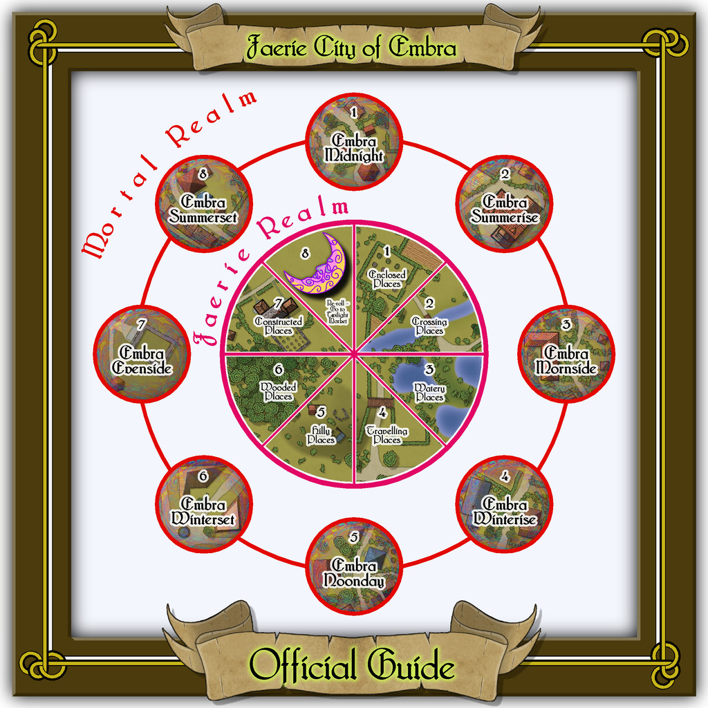
The final Village knotwork design was based on a couple found online, although one of those, what turned out to be my final choice, was also virtually identical to one in the Dover Clip-Art "Celtic Borders on Layout Grids" hardcopy book, mentioned in the introductory Forum topic as well. This then is the map for the "north" Village, Embra - Midnight:

The nature of these eight Villages, on the border between the Mortal and Faerie Realms, invited adding something to each map to reflect that, hence the pale, misty, oil-iridescence colours towards the edges, fading into the middle. This also gives a suggestion of viewing the map through an old, round window, lens, or in a mirror - Embra Through The Looking Glass, perhaps. That oil-patterning comes courtesy of @Loopysue's transparent City Domes symbols from CA144A.
Although scales and an unlabelled compass-rose are provided, nothing in the Faerie Realm is strongly fixed, so while the map is correctly drawn to the scales, GMs can adjust those distances, sizes and directions to best-suit their own needs. Similarly, the featured text below the compass-rose alongside the map can be used, adapted or ignored as the GM may wish. It was determined by a random tarot-card draw, as described previously, as an interpretation of what the card artwork showed or inspired.
Place-names on the maps were sometimes taken from their obvious nature, the surroundings of Embra as established on the Clack Valley map, my own earlier RPG mapping, or more commonly from a random choice of adapted names in Celtic mythology, primarily drawn from entries in James MacKillop's Dictionary of Celtic Mythology (Oxford University Press, 1998). Some of these are explored a little more in the PDF and text notes accompanying each map. The placement of the labels is necessarily somewhat obstructive at times, so a toggle in the Atlas FCW versions will allow them to be switched off for better clarity.
A second Atlas toggle on this Embra - Midnight map allows simple internal layouts for each building to be shown. The original Judges Guild settlement maps were always drawn like this, showing only cross-sections through the surface level's outer and interior walls and doorways, for almost every building. Indeed, this was established so early as the norm for RPG settlement maps, that I still struggle to make sense of the more recent RPG tendency of settlement plans that DON'T provide this option, but show just a - to me - sometimes confusing series of rooftops. This was part of the reason I decided to add this element for the Village, and many of the Places, maps for Embra, although a lesser aspect was I found it wasn't always easy to tell where the buildings were on some of the more heavily-vegetated maps. Most of the buildings have just a single room inside, while all occupy only the surface level on this map:
One aspect on most, but not all, these Village maps is the River Clack, which, as the Clack Valley map indicated, runs through the city. In Embra - Midnight, it is quite narrow, and crossed by a ford. Elsewhere among the Village maps, it can be broader or narrower, and bridged. In some cases, it becomes almost ditch-like. This variation, while adopted from the Judges Guild base-maps, was a deliberate choice from very early in the planning and construction process, to emphasize that Faerie is not the mundane world outside, where things may not be what they seem, even at such liminal places as these "outer" Villages.
While the Atlas connections favour moving from outside to an entry-village, and then on into parts of the city itself in Faerie (or reversing the process when wishing to leave Embra), there is no reason GMs could not opt to move the party from one Village to another as an extra possibility too, perhaps camping, or taking rooms at an inn, in one Village, only to wake next day in a quite different one - perhaps where the inhabitants are identical, say, for a little further confusion!


![[Deleted User]](https://secure.gravatar.com/avatar/c75d9a245b74d9c59be0999ea81ca541/?default=https%3A%2F%2Fvanillicon.com%2F92add7f8c954488718110edc4896ad39_200.png&rating=g&size=200)

Comments
Next in the sequence is the northeastern Village, Embra - Summerise:
Here, we have a broader River Clack, if still one with a ford. There are fewer buildings this time, although a couple are larger properties, particularly Mide House, treated as an inn in the accompanying map notes. In addition, there are two "interior" toggle options, one for the surface level:
And a second one for the upper floor of the inn:
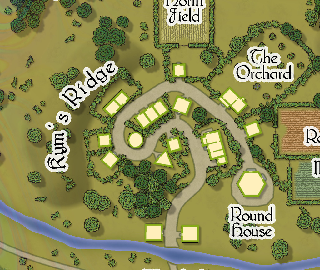
The eastern village is Embra - Mornside, a name partly influenced by the real-world district of Morningside in Edinburgh, although naturally, it also fits neatly into the general naming conventions here (none of which is merely coincidental!).
Now the broader Clack has a small island in it, and one of the tributaries from the Clack Valley map features as well, the Wadingburn, in an especially prominent form.
There are more buildings too, a mix of larger and smaller properties, one of which, Gofannon's Farm, has an upper storey:
Continuing the circuit of villages brings us to Embra - Winterise, on the southeastern side:
A neat little village on the road, that seems curiously separated from the narrow River Clack here, with its mysterious bridge that no track leads to, and some equally mysterious ruins atop Gargam Hill. This time, the properties are all of only a single-storey each:
The southernmost village, Embra - Noonday, has a particularly narrow Clack stream, yet one that both the main near-Embra tributaries from the Clack Valley map, the Silverburn and Wadingburn, join by the east edge of this map:
Although there are more buildings this time, each is still only a ground-level property:
Embra - Winterset in the southwest moves things towards a somewhat different nature, with many clustered properties, and no River Clack. Water comes instead from a pair of well-fountain pools at two midline crossroads, while the not-quite enclosed areas of Aine's Pastures are connected by a bridge that arches over the northern trail, a particularly obscure - thus clearly Faerie - feature:
The interior views show what the layout of the properties really is, although there are many fewer two-storey buildings, as the lower image here demonstrates:
The western village of Embra - Evenside carries things to an even stranger place, now with a "castle", Caer Sidi, that is really just an elaborate stone fence around an open field! The Clack here isn't a stream, but a series of ponds linked by marshes that have a couple of bridges over the swampier spots. There's also a huge orchard, and a second dry valley with a scatter of marshy ponds along it too:
This is one map which I think especially benefits from a means to help identify which mapped items are genuine buildings:
Completing the circuit is Embra - Summerset in the northwest, with its small village of single-storey properties, the River Clack with a bridge (albeit the bridge seems detached from the village rather), both the main Clack Valley tributaries, plus a curiously unlabelled third tributary stream, which seems more significant than the named Silverburn (a deliberate choice!). However, dominating the map's centre are two substantial lakes and a marsh:
Next-up will be the first of Embra city's contents, the Enclosed Places.
Is the close up outer glow size intentional ? I have problems with that myself.
I'm assuming you mean the glow around the lettering, Jim. It's the size it is quite deliberately. It's fixed so the map labels are legible when viewing the complete map. I found it didn't work sufficiently clearly at smaller sizes. The close-up version is really just because the Forum resolution isn't that great at showing details so well, so the glow seems a bit much in some cases.
Okay, understood. What works for me at map full size, I zoom in and the outer glow appears to be covering a county or two worth of land.
To make zoom-friendly glows for text, use the Percentage of View Width effect scaling option. This means the width will be relative to the current view, instead of the map. Of course, this also requires a very different size setting for the range of the glow.
This is really something. My only recommendation would be maybe to put a dot on the rose so you can easily tell which direction the village is relative to the center city.
Yeah, I did think about that some time ago, but there's also the problem that the text's position shifts at different resolutions, such as when you zoom in or out. I've tended to work texts at just the full-map resolution for some time now because of this, so that I know exactly where the lettering's going to be. Thus if I can't read the text clearly at that level (and I usually do an A4 test-print to double-check), something has to be tweaked. In this case, that was the size of the glow.
Thanks for the compliment!
As for the positional dot, there isn't any real point to doing this, because the village's relative position is only of potential importance when approaching the city from outside (when the direction would be obvious anyway), or when moving away from it. In one sense each Village actually IS the entire city, but at a level only visible on the Mortal plane (so it only seems to be a little settlement). In addition, GMs can opt just to pick a Village, or decide one randomly, for the players to encounter when trying to reach the Faerie version of Embra, rather than using their approach-direction, so again that would invalidate such a marker.
Good point, Wyvern, forgot about that random option. The lens effect is a brilliant idea, especially the oily film.
Some new maps from Wyvern in the atlas here. Didn't have time to process all of them, but there is the selection so far.
An absolutely fabulous set of maps - fascinating story, and visually wonderful. I think this is the best yet from @Wyvern and that is saying something. The visual appeal is just so enticing - and inspirational
Thanks very much Quenten! And we've hardly started them all yet 😎
(Hoping to post about the next set, the Crossing Places, later today. Hoping...)
One thing regarding the Embra Village maps (only) that occurred to me, but time didn't allow discussion of when I posted about these earlier, is that it might be possible to add versions of them elsewhere in the Atlas too.
This is because I left the original "wooden" square frames on them all, but concealed in the current final Atlas versions using their "Embra"-style circular borders. This is the Embra Midnight map without all its Embra labels and trappings:
Obviously, it would need further work to fill-in the outer blank areas, as I didn't carry the surroundings much beyond the circular border, but that wouldn't be a huge amount of extra effort.
It seemed to me it might be fun to add them to places on continents other than Alarius (where such loosely European-style, temperate/cool temperate agricultural villages might be appropriate, of course), and perhaps suggest in their accompanying notes that there could be a secret way to pass directly to the "originating" village from the Embra set, if player-characters can but find it. Naturally, there couldn't be a direct link in the Atlas otherwise. Maybe one revised Embra Village per continent, say?
It would be preferable to not have to adjust the established parts of the map, although labels and smaller areas of terrain or vegetation could be changed or added readily enough. Thus the overall layout of each of the eight Villages as shown in the earlier parts of this topic would be retained more or less as-is.
Thoughts? Or ideas for where these might be set-up, if this seems interesting?
That's a great idea!
Magical instances of the same village globally, as if the whole village is a portal that (if you can get in) will allow you to exit into a number of different places.