

Yet Another Wargame Map set in ...
 mike robel
🖼️ 15 images Surveyor
mike robel
🖼️ 15 images Surveyor
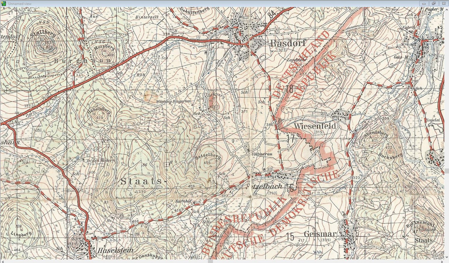
You guessed it in the V Corps area of Germany in the Fulda Gap. This one, while in the same area, is a little different and is centered on Rasdorf which is very near the old Internal German Border. Here is a map of the region, covering an area about 5 x 8 km. the scale is 1:50000 and each square is 1km
I'm making the game for a game called Assault which was set in the late 80's and I used to play it for both enjoyment and for training my officers. You can read about at https://www.boardgamegeek.com/boardgame/8284/assault-tactical-combat-europe-1985 if you are tired of making maps for the moment.
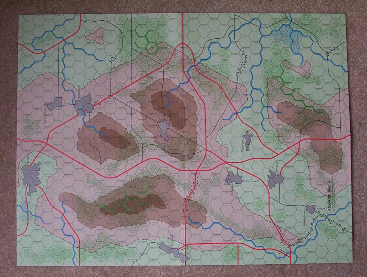
Here is one of the maps from the game. They are based on German terrain, but are isomorphic and very generic and I don't like the roads running in the center of the hex, streams on the hex edge, and other features contained within a hex or a group of hexes. counter interval here is 20 meters, but you can say it is anything you want. The map scale is 1 Hex = 250meters and the unit scale is platoon (3-10 vehicles).
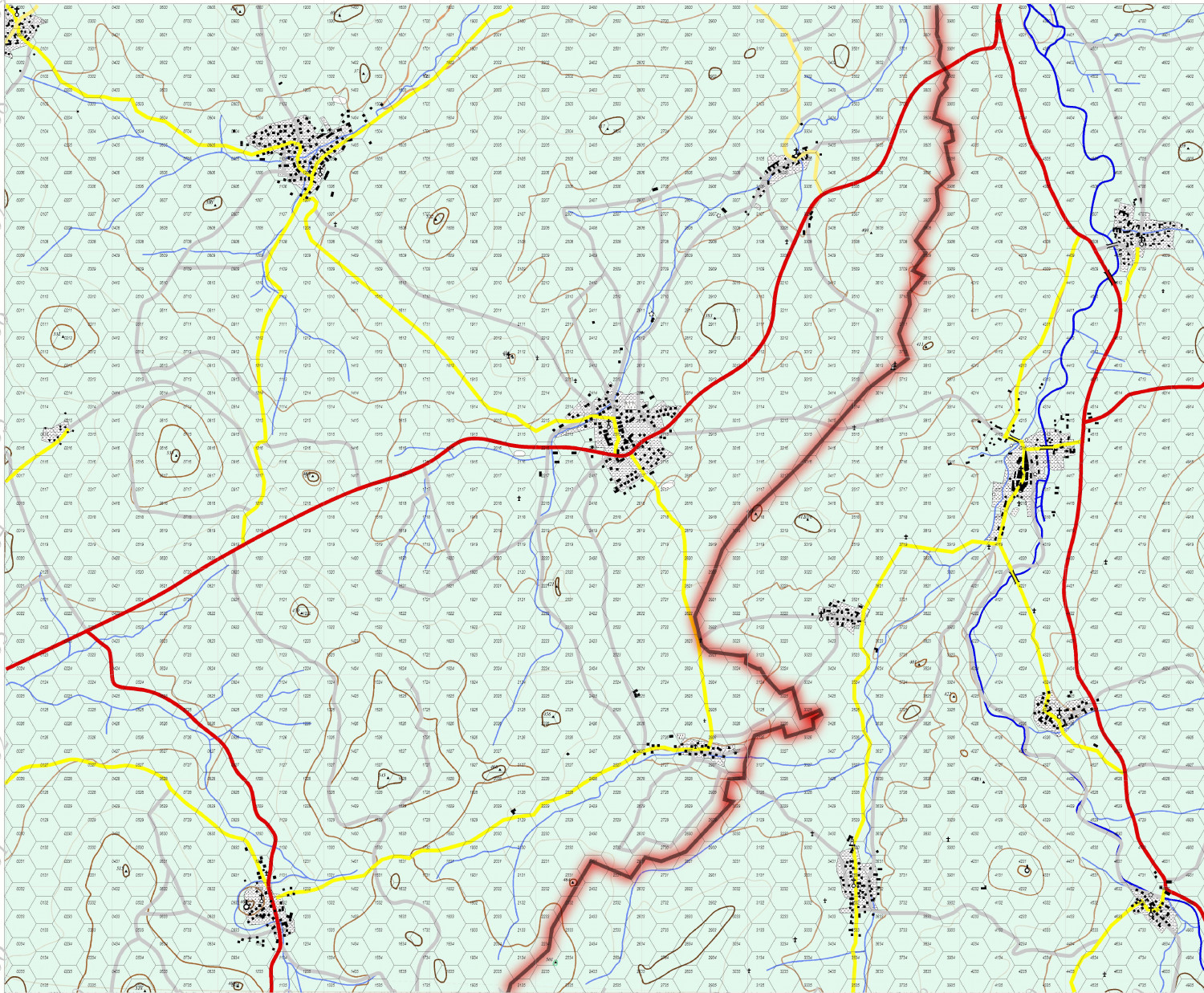
This is a copy of my game map in progress. I had to blow it up to the Assault Scale, so it is much larger than the top map. The map measures 30 x 37 inches or so. (sorry about mixing measurement systems.) Rasdorf is the city in the middle and Setzelbach is directly below it and very near the Red/Black line which marks the Interzonal or Inner German Border.
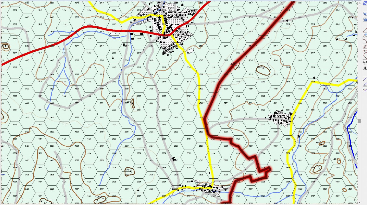
This map is sized to about the same hex size as the Assault map above. The town at top is Rasdorf and the smaller one at the bottom is Setzelbach. My tank and cavalry platoon would occupy an Observation post for three weeks about once every quarter to provide surveillance of the border, the OP is now a museum and sits just about where the light gray road exits the map to the north near the Border.
It's getting close to finish. I have to decide if I want to put in more contour lines, fill in the contoursso they are easy to interpret, and detail the areas of forest.
Enjoy


Comments
For those here who may be unfamiliar, the original 1983 map from Assault is very typical of the board wargame maps of the 1970s-1980s in general. The features you dislike Mike were exactly what made the games playable back then, as well as reasonable simulations for the level of combat formations they were designed to show. The key features were that everything had to be clearly in an identifiable hex, or on its border, if it had any effect on the game whatsoever. So we were all very used back then to working with maps like this, and personally, I always preferred this idea to adding a hex grid to a real map, which never seemed workable to me as a board wargame mechanic (still doesn't - sorry!).
Even so, always like to see how your maps grow, Mike!
@Wyvern You are totally correct placing the features in the way I don't like leads to easier play. I adjust the feature to make it obvious where the feature lies. For roads its not a big deal, but for rivers, you pay the cost when you leave the hex and there is no cost when you move along the river line. Line of Sight issues always occur, and I just have the players resolve the issue if they can't agree with a die roll.
In my younger days, we would play computer assisted simulations in the main Fort Riley gym, on moving map tables with maps blown up to about 1:10000 scale using micro-armor. As the battle shifted, we'd move maps in our out of the play area as the game unfolded. We had to talk about what we could see and do before we filled out the battle form and took it to the computer operators. Several times, late in the game and usually late at night it seemed fist fights might break out as the arguments became heated and ones map reading skill, as well as other qualities and abilities might be called into question.
Regardless, I try to make my map and rules as clear and understandable as possible. Since battle is chancy, if players disagree I tell them the challenger gets to roll a die and if its even he wins and odd the challenged wins. If in the other players turn, they have to roll again to determine if the issue changed.
I'm a moron. I didn't scale the drawing properly. The dot's you see in the background are 0.1 inch apart, the hex is 25 dots wide and each dot is 10 meters apart. Therefore I have spaced the tanks 10 meters apart, not 100. The second picture below shows the correct spacing at 100 meters.
The other thing to remember is tanks are tiny and hexes are large. The Hexes below (in the second diagram) represent the typical width of a 1000m battle position I would allocate to a platoon to give them plenty of room to shift position in the defense or to move in the offense. The M1A1 tank is scaled to represent its length and width (9.77m x 3.66m) with the typical 100m spacing between tanks. Seldom would the tanks of my company in the same hex, unless I was in the final assault. They can be anywhere in the hex and you can bet they would look for the most advantageous position for themselves as they could find.
The 6 red dots in the second diagram represent the impact of each round while the circle represents the burst radius and together represent the beaten zone of a volley from a 155mm artillery battery. A single volley would do little, if any, damage to the tanks.
The black square represents the counter size.
Diagram 1: Incorrect. This rendering has the tanks spaced too closely together.
Diagram 2. Corrected. This rendering has the tanks spaced correctly.
You can see the battlefield is empty space and an individual tank or person can be virtually anywhere inside the hex. So measureing from the hex center is an inexact representation of what occurs. But no one wants to get into computing line of sight mathmatically (except maybe in a computer game) so it is good enough. The 100 meter spacing is somewhat elastic. The platoon could get pinched down to a wedge in which the tanks are only 10 meters apart or even into a column, but you do't want to that close together.
As Sherman said, "Men are not blocks of wood," but neither are blocks of wood (or cardboard) men or tanks.
Here is a shot of me in front of my first tank. The woods are moderately dense, but LOS in blocked pretty well if you are trying to see in, but is pretty open when looking out. Until you shoot and the muzzle flash gives you away. Then you need to move, which is why I gave all that space to me tanks. Today with thermal sights, hiding is much harder. Better to dig in and not turn on your heater in the cold.
A Boy and His Tank.
Lastly, this last shot shows the difference in range from WWII (an M4A3E8 76mm Sherman tank) versus about 1980 (An M60A1 Main Battle Tank) overlayed on a section of a 1:5000 map near where my map is. A glance easily shows several places where LOS is blocked and areas where tank would have a difficult (slow) time trying to move through.
WWII Range vs 1980s Range
More than anyone here probably wants to know. :)
Well. I decided to fill in the contour lines using the special palette Monsen made me with 48 shades of green and changed the contour interval from 50 meters to 20 meters. The 50 meter contours are still in there. Because I have trouble following contour lines, I decided to work backwards from highest to lowest. I thought I was saving regularly and saved the thing this morning a little while ago because its the 29th, not the 28th, but I obviously failed to "early and often" because the thing crashed and so I lost about an hour of work.
At any rate, here is an overall view of how things are. It will look much better.
The black lines are the 400 meter contour interval. When those are all changed, they contours will start to meander more and spread across the map. When I am done with this I will have to decisions to make. Switch to the 48 brown palette Monsen made for me and/or skip a color between contour lines (instead of 196-197-198 go to 196 - 198 - 200) to make the elevation change easier to see for my poor eyes.
Sue will be annoyed because darker is higher. :)
, but I will be able to focus better on where they go.
You make some good points Mike. I must admit, I never thought hex map boardgames worked all that well for tactical-level wargames, where I always felt using models and miniatures on a physical tabletop was much more useful and instructive as an attempt at simulating something of the realities. All the board wargames I still own, and occasionally play (not sure how I found the time when I was younger; never seem to have enough now!), were of a far more strategic level (so where a single turn is always at least a day, for those less familiar, and the ground scale is matchingly large).
Thank Wyvern! I don't like miniatures much. They are in general too out of proportion to the field and many systems are much too slow. And it is so much work. I just sold all my MicroArmor to a friend, gave away my Star Fleet Battles stuff to another. I still have my 1/285 pieces from FASA's Renegade Legion, and I have a phalanx modeled in 1/72 scale just because its cool (not the whole thing, just 4 ranks by 10 or 12 files, but only with spearmen) and some Macedonians still in a box.
I suspect my (ongoing) connection to miniatures (and scenery, and everything else that goes with it) is because I started out as a model-maker, and only got involved in wargaming proper a few years after that, at the end of the '60s and early 1970s. Many tabletop rule systems are, and always were slow, but most of what I've done has been for my own interest and solo, so that was never a great issue for me. And a lot of the larger-area battles are fought using the miniatures as little more than markers, so I quite understand your "scale" problems.
I never understood why so many wargames have to be "balanced", when reality very rarely is (unless somebody's really screwed-up their reconnaissance and planning), which I think is why I never took to needing a group to game with. That was just too much like chess to me, whereas I wanted to try to better understand real, or potentially real, situations.
I pretty much agree with you. I think the difference between a game and simulation is the presence of a training objective. That said, the purpose of game is largely entertainment.
I started building models and playing wargames pretty much in third grade, I played miniatures to some extent, Star Fleet Battles, FASA Starship Battle Simulator, Battletech, Renegade Legion, Harpoon, and micro armor, but I've gotten rid of everything except Renegade Legion and I sold my Battletech games a long time ago after losing my miniatures in a move from CA to KS before Desert Storm.
That said, I do have a display of a 1/72 Spartan Phalanx, 10 - 12 files in 4 ranks, all with spears either pointing forward or up and a pack of Macedonians that are unbuilt.
Games should be able to reproducer, within some bounds, the historic event but allow the either side to win. For instance, against a competent general, Hannibal probably should have lost. The French may have still lost because coming through the Ardennes surprised them, but the French/British should be able to set up as they wish and react as they wish to avoid the same mistake. (Never mind that most games may rate the Germans better than they really were and the French/British.
If you want to ensure a historical result as much as possible one should have detailed setup instructions and rules supporting it.
Simulations should be as realistic as possible and conform as much as possible to the available facts. Since World War III games/simulations have no historic data available, you have to guess. For one example, I don't think one should rate ones force as anything but average, unless for some reason there is a common opponent that is clearly less than or greater than in talent worse than a force. So, we treated the Iraqi's in Desert Storm as much more competent than they were.
Here is a look at the map after I converted contour lines from 50m to 20m interval and filled them in. When I finish, I will outline in each layer with Brown to make them more distinguishable. The difference between some colors is too hard for me to see although it is somewhat more obvious when printing. I really like the effect and many thanks to Monsen for the custom palette's he made me.
I may, though I am dreading the work and thinking required, to skip a color to emphasize the color difference between each layer.
I am uncertain how to deal with showing the extent of the forces. Usually I just use a green fill and make it transparent. I probably will do that, then fill it with the individual symbols for the type of forest (deciduous, pine, mixed) but I find filling an area with symbols is problematic and I either get way to many or only a few and it varies by shape and size, so I may end up just plopping symbols in place. You can look at the topo map to see how they look, which is the effect I want.
Also need to text.
Sometimes, things just go well. I thought the colors were too vibrant for Germany, so I made them 50% transparent. I still may need to town them down.
Also added the Forest. Decided to go with a Green Outline and then put the symbols inside.
Well, I think it's done, except for placing the borders on the contour lines and deciding if I want to change the color scheme.
The hash lines represent really steep slopes or embankments, cuts, etc. They provide some protection in a direct fire engagment and stop movement across the hexside. A cumulative effect is provide in the case of gaps. If you are moving parallelly to the embankment, there is no penalty unless you exit perpendicular to the direction of the embankment.
and with the Brown Contour lines drawn around the polygons
Here I skipped a color between contours (instead of 200-199-198 its (200-198-196) between layers which I think improves it.
Nothing to see here. Not the Droids your are looking for. Move along. Move along.
So, did I read right? You aren't using miniatures on your maps? BTW, awesome work. I wish I had the patience to draw out contours heh.
Cal
Yes, I would be using the game Assault to play. I used it when I was in the Army to train my officers and think about tactics.
https://www.boardgamegeek.com/boardgame/8284/assault-tactical-combat-europe-1985
Well, it's just excellently done, man.
Cal
Thanks! I tend to think my maps are rather boring as compared to most maps on the forum, but they are the way I like them. :)
but they are the way I like them.
Well, that's the main idea behind making maps, isn't it?
A map doesn't have to be some sort of artistic masterpiece to be a great map, a map should fit the intended use case. Visually stunning doesn't always make for a good map.
I agree with Remy.
And just because I make lots of those arty type styles it doesn't mean that I don't find the more practical maps interesting and beautiful. I once trianed to be an OS cartographer ;)