

Endoria
 Jeff B
Betatester 🖼️ 39 images Surveyor
Jeff B
Betatester 🖼️ 39 images Surveyor
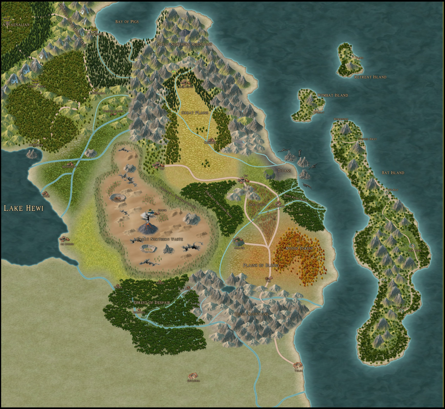
I have been working to bring the World of Endoria to life in CC3. The person I'm doing this for has been running a DND game in Endoria for 20+ years now and I'm building the map from his collection of crude pencil drawing and filling in the rest of the world as I see fit. The world is huge and it is taking longer than expected but I'm making progress. Now that the August Contest entries are completed I have been able to work on the Monster Lands and surrounding area to produce a regional map ina jpeg image as I have not broken out the region into a separate map yet.
I decided to post what I have been working on to get some feedback into what I can do better and what I maybe missing. The style is Sue's Overland Spectrum with building from Darklands.
I may post the entire map later as it is currently rough and only has some areas fleshed out but not real happy with some of those areas. So here is what I'm currently working on.


![[Deleted User]](https://secure.gravatar.com/avatar/c75d9a245b74d9c59be0999ea81ca541/?default=https%3A%2F%2Fvanillicon.com%2F92add7f8c954488718110edc4896ad39_200.png&rating=g&size=200)


Comments
Are you importing the sketches into cc3+ ? You can put them on their own sheet and layer, then use them as a guide.
I've done that with several hundred 5mm hexagon paper maps.
@JimP
Yes that is what I did but most of the areas are pretty blank with just some landmark stuff.
Well I knew this was going to happen I just ran into memory issues trying to export the jpeg. This is a huge map with lots of stuff so now I need to figure out how to either reduce the scale or start over which I really do not want to do.
Here is what I have now. lower resolution as I could not export any higher.
You may want to reduce the amount of Edge Fade, Inner.
Thanks Quenten I'll do that.
That worked I reduced the edge fade and now I can export at a higher resolution.
By the way the city of Torlok is between the forks of the Bligh River.
I'll look through the atlas and see if I can find a spot for the Torlok map if not I'll ask for you help Quenten to find a spot for it.
Larger the map, the fewer the symbols should be used. Otherwise you run into a rendering and exporting problem.
For the largest cities in my Crestar site, I made them either in pieces, or a generalized map, with smaller detail maps.
Those two methods likely won't work for the Atlas.
Good-looking map!
My immediate thought beyond that is that some of the broader rivers don't appear quite right. In places where they merge, there's often a patch of darker blue in them which makes them seem a little disjointed. I suspect that may be because the inner glow effect on the rivers sheet needs tweaking to be a little larger, perhaps (it may be something else, as this isn't a style I've used much, or very recently, however).
Also, there's the common problem with river lines where they meet the coast, that they don't match up properly with the coastline, and can seem to run into the sea, with a colour mismatch. Sometimes you can adjust the final node on the river line to match better with the coastline, though sometimes not. One alternative is to add a small polygonal patch of the appropriate sea fill texture over the end of the river line, although even that sometimes doesn't work as well as you might wish.
A further alternative is to set up the land sheet with a Color Key Effect, which effectively "cuts out" the rivers instead of superimposing lines on top, so essentially the rivers become long sea inlets instead. The downside is you have to draw the rivers on the land sheet as well, and in a solid fill of a single colour (by default, this is Colour 6, bright pink). You can though make your rivers look a lot more natural that way, especially if you draw them as polygons instead of lines (this can be a bit tedious for long rivers, however, as you have to draw both banks), or add polygons to disguise where river lines of different widths meet (so the main river line can vary in thickness along its length in a more "realistic" manner than a single line width will allow.
@Wyvern
Thank You for the river tips I will be looking at that as I really hate the get the rivers to match with the coast line and attaching to different river sections.
I like the Spectrum Overland style but I wanted to use a different style for this map but the guy I'm making it for wanted this style.
Well I decided to post in this thread instead of creating a new one. I have finished the eastern portion of the world. I know this is a large map with way too much detail but that is what the person I'm doing this for wanted and it's too late to change now. He plans on printing a large format print with detail to hang in his game room. He created this world over 40 years ago and had very little of the world explored so except for the area he had already mapped out I'm able to have free rein over how it looks.
I still need to update political regions (turned off on this posting) and label the rivers but most everything else is completed.
Once the map is completed I add sea contours and a few islands along with scale and compass.
larger image in gallery
comments and suggestions welcome as always
Ok the over detailed map of Endoria is completed. Well almost still have to do political regions and do some font work and naming. I know there my be some areas that need a little work still.
Comments and suggestions welcome. - Larger image in gallery
It's quite beautiful :)
If anyone is interested the map uses the follow styles:
1) CA163 Spectrum Overland - Main Style
2) CA173 Darklands - symbols and fills
3) CA63 Herwin Wielink Overland - Symbols and fills
4) Mike Schley Overland - Symbols
5) SS5 Cities of Schley - Symbols and Walls
6) CA170 Banners and Seals - Symbols
7) EucalyptusNow - How to Create Decorative Symbols by Tracing Tutorial (Not shown on posted map)
Made changes to map today after meeting with the person I'm doing the map for. I redid some rivers added mysterious island, changed some text items (size and font/shading) and removed over 200 cities towns etc. Updated map is in Gallery.
Also turned the hex grid on for printing.
Looks like we are about ready to print. Taking it to the printers Tuesday and size of print is going to be 48" x 36" unless printer recommends a different size.
Working on getting the Hex transparency correct for the printing. Added higher res to galley.
We picked the version with the Gray Hexes to print. Print Size 54" x 41". Should be ready to pick up mid next week. I'll post some pictures of the final product after we pick it up. He is also having a tabletop version done at 24" x 18".
Wow, that's large!
Lovely map :)
He was going for 6' x 4' but the printer said that if he went to just 54" he could use the high resolution large format printer and get the best image possible so he went that route.
Now I need to get the political regions done so he can have that printed at 24" x 18"
The map of the political borders was approved today.
Larger version in Gallery
Congratulations :D
@Loopysue Thank You, I will be glad to see the printed version of the regular map after 6 months of work that I put into the overland map. I'll get a couple weeks break to work on my stuff then it's dungeon maps again. It was a really good learning experience.
We picked it up from the printers today.
Started as this
Finished product. Blurred out owner of map.
amazing! Congratz @Jeff B
Thank you