

my Crestar, Northern Hemisphere, several continents, Zaggah nation
 JimP
🖼️ 280 images Cartographer
JimP
🖼️ 280 images Cartographer
I did find an old discussion about the northern hemisphere, back in 2011. But I decided since I'm attempting the Schley overland monthly symbols, I would start a new thread.
first map is the Zaggah part of the continent, and then the part I have done so far.
Second map has rather wide paths through the mountains... I'll work on reducing those.
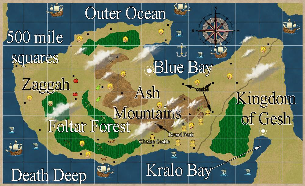
Dread Peak is in the top part of this map which is 1000 x 800 miles.

Comments
An update, larger in my gallery.
Yes, on Crestar there is an Inner Ocean.
Added dwarves, elves, crops, horses, a forest, a few more ruins in the northeast area.
Larger 3000 pixel in the gallery.
Added a few large rivers, more text, bridges. I have the bridges in two colors. Not sure why yet, but I'll come up with something.
3000 pixel in gallery.
Two ruined bridges where it says Ice River.
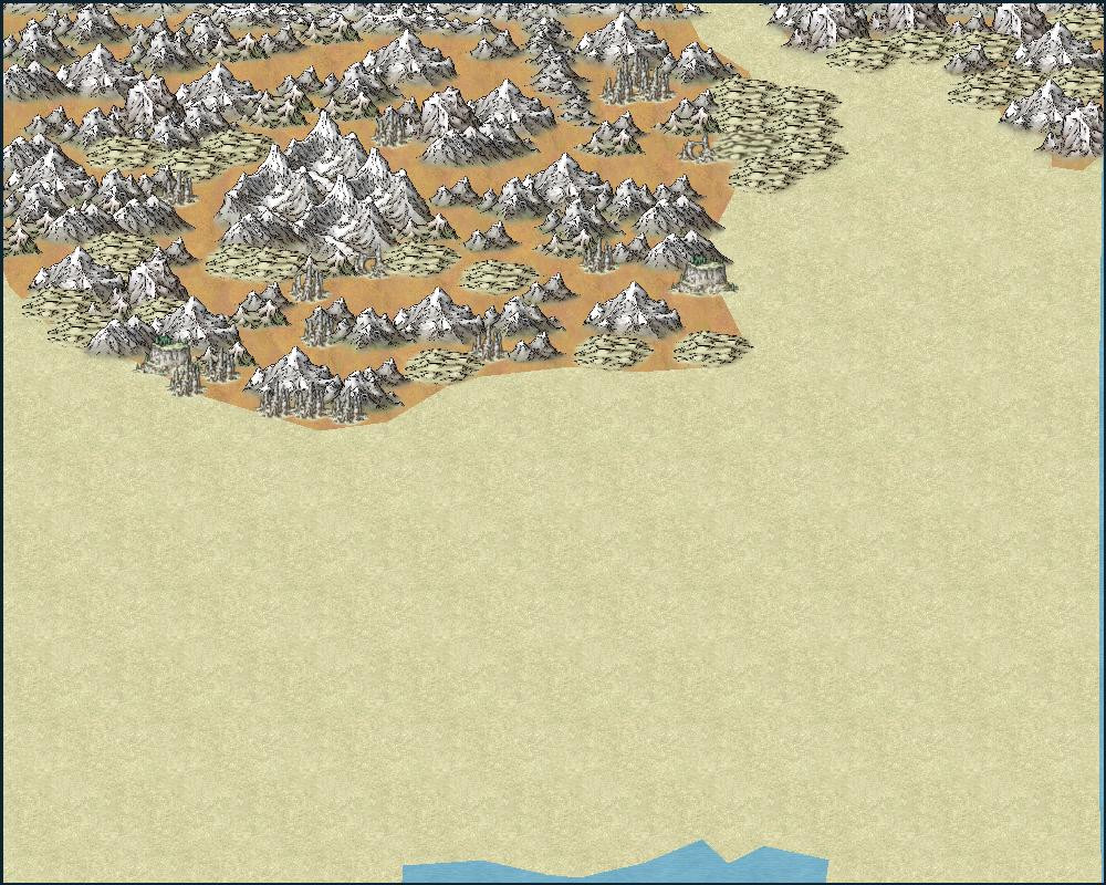
I think this is a bit crowded... do I need to add more mountains and hills into Ash Mountains ? Some of them seem rather far apart to me.
3000 pixel in my gallery.
Smelter River so named due to the dwarves not always being careful what they dump into the river. And that is why the last 2 bridges on that river are brown, pollution.
A couple of hill side towers add in the mountains, and two henges.
I don't think it's crowded :)
I think that maybe the labels could be a tad smaller.
I do think you could fill in some of the empty space in the mountains with smaller mountains, cliffs, lakes , small valleys and a few rivers and hills.
I'll check into those ideas Monday afternoon. Bit busy, hopefully won't take long, in the morning.
It depends how you see the mountain range Jim, I think. Not all mountain ranges are crowded with mountains in reality, after all. Some of the "empty" spots could be hidden valleys, or even plains, with impassible mountains all-round, like the classic Shangri-La.
If the Ash Mountains are more than a name (so something like volcanic ash), maybe the valleys there could be grey with ash too, where nothing will grow, say, if you want a little more variety. Or maybe a scatter of a few trees here and there (really as much for decoration as indicating any genuine small woods, perhaps).
Update, let me know what you think. 3000 pixel jpg in my gallery.
Text down from 20 to 15. I didn't change the mountains and the ocean names.
Added forests in symbols and the two forest tools. I may make a scrubland tool. The changes are all in the mountains, or nearby to them.
I need to keep an eye on the sheet shown before I place the symbols.
The labels are a much better size now, Jim. The whole map looks better because the labels aren't overpowering everything else :)
Thanks.
I tried the view size for the text, for the outer glow.
That is a bit larger than in CC3+. I think.
Anyway, here is the closeup.
I did drop the text range one bit smaller.
Anyway, I was thinking about mapping the area around some of the towns.
Maybe add them to the Atlas ?
I'll start working on adding small towns to Forlorn Archipelago.
Thanks for the encouragement Quenten. I forgot some events were going on in Everquest II, but I'll get started on this.
I'll look around Forlorn and see what would be some places to put a few villages, and maybe a small town.
edit: And I'll get a fresh map.
Okay, another necro. And I got a fresh map just now.
Oh, yeah I'm already working on maps for Fisher Island. Argh. Forgetful.
And another necro.
Looking at my Crestar and Old Crestar sites... Well, I had originally put South at the top of the maps as some of my players had a difficult time remembering Crestar isn't a parallel Earth.
So, yesterday I am checking the maps... and I find some still have South at the top of the map, and some have North at the top. Some continent maps are rotated and some not.
I'll be fixing that over the next month or so.
Edit: I don't think I added the above new map to either site. More looking and adding to a spreadsheet I suppose. Argh.
I've updated most of yhe maps for a starting country Dank Forest. Along with some of the Islands on Old Crestar.
On my cell, I'll post some examples later today.
Brillar, Dank forest's capital.
center of the city, old map.
Newer map of the city.
While the second one is still using older symbols, I'm more working on changing out the CC2Pro symbols for CC3+ ones.
A more up to date map: Crestar, Northern Hemisphere, Barrow Islands, Long Tooth, center area.
I was going to work on this today, villages and towns on the Forlorn Archipleago, but got busy doing other things.
Medina Station started giving me a headache, so I'm switching to these villages/towns and working on Crestar for a bit.
Here is a map of an adventure area, one store and my home players went on this one. Crestar, Southern Hemisphere.
Both groups decided to go up the river valley, with the steep sides, and boulders washed down from upstream.
Water started rising, and they got their characters up on the ridge. I thought the scree and loose boulders was a ... dead giveaway.
To the lower right of the word Watchers, are the ruins of a dungeon. Right about where X marks a spot.
I was looking at the two hemisphere maps and decided to make some area maps in the Northern Hemisphere.
I made one, the one below, and then noticed that most of the maps for the continent Darshan, had no affects on them. So I added them to several of those maps.
The black line is a border, mostly friendly to each other... however, someone has been going back in forth across the border and apparently trying to stir things up... but no fatalities. But note there are no roads crossing the border, they may be off the map.
An arrow fired at an empty hut, carts turned over... and foot prints of goblins and orcs... but wooden feet have been found that seem to have been used to make the suspicious footprints.
I probably wont elaborate further.
Decided to make two ruined towns in the broken lands part of Crestar's Flat continent.
First one had towers, no walls. Campers on the west side, probably looking for loot. Or maybe trying to rebuild. The well is ruined. Probably easier to tear down and start over.
Looks a bit newer, even an attempt to build walls. Looks like they were too late as there are just two ruined corners on the Northwest and west areas. Three partial buildings, must be newer. All is ruins. More campers ? Five ruined wells. Downed trees.
Have you considered using a different style of roads? Those dashed lines works on overland maps because they're only representative of the feature, but on close-up maps like these, they come out looking a bit out of place. Maybe a dirt brown fill with a small edge fade instead?
I wanted to give them a look of not being used. I'll be busy tomorrow out in the yard but I'll check on them Monday night.
Here are the updates. I changed the line style to solid, and the fill style to cd3b cobble brown 1.
I know its different than you suggested Remy, but I wanted to try this.
Hard to see on my cellphone, but on my 40" screen I use with my desktop computer, the paths look worn and brown from not being repaired.