

The Mapping Game
 Monsen
Administrator 🖼️ 46 images Cartographer
Monsen
Administrator 🖼️ 46 images Cartographer
This is a fun little collaborative game that anyone with CC3+ can participate in, no matter their skill level.
The concept is simple.
I post a starting map with both a picture and an .fcw and say something like
"I challenge the next mapper to add an island"
Then, whomever wants to pick up the challenge posts a message claiming "this is mine" or similar. (To prevent multiple people working on the same map simultaneously)
Once you have posted your claim post, double check that nobody actually managed to post a claim before you.
Assuming not, download the fcw from my post, add the feature requested, and when done, post an export and the fcw with a new challenge for the next mapper.
And then we just continue like this, improving the map one small piece at a time. Always continuing on
Each person can (and is encouraged to) participate multiple times, but don't handle your own challenges, make sure others gets to have a go in-between, even if it takes a little bit of time.
The challenges are intended to be small, something anyone should be able to do in a couple of minutes.
The challenges should not be too specific, let the mapper who picks up the challenge interpret it. Avoid telling them where to do things
When taking up a challenge, you should only do what the challenge requests, don't go around adding lots of other details to the map. For example, if the challenge asks you to add an island to the map, you draw an island landmass, you don't fill it with terrain an symbols, leave that for a later challenge. Feel free to make the coastline as detailed as you want however, that would be within the challenge of the example I used here.
Features added by others shouldn't removed, but some alterations may be fine. For example a challenge to add a bay to an existing landmass.
A challenge can be about adding or improving a feature, but could also be about effects, for example "Improve the coastline effects"
Always give a challenge based upon something you see the map would need, but let the mapper taking the challenge decide about the details (size, shape, location, amount, etc)
To keep this available for everyone, only symbols/fills that comes with a core CC3+ installation should be used, but all the styles included in base CC3+ is fair game. But no resources from add-ons, annuals (even free ones) or community symbol sets or custom images that needs to be installed.
From you claim the challenge, you have exactly 24 hours to post your modifications along with a new challenge. If you fail to do so, anyone else can claim the challenge instead, as you are considered to have abandoned it. However, each challenge should not take more than a couple of minutes, so I recommend you post your modifications and new challenge within one hour. If you can't start right now, it is better to wait and grab the challenge when you have time.
Discussions and comments are fine, but remember, once someone has made a feature and posted their map and the next challenge, this is it, don't tell people to go back in and change the flow of the river because it looks unnatural or try a different effect. Maybe someone will later post a challenge based on such suggestions, but this isn't a WIP thread where you give the mapper tweaking advice, neither should anyone implement random advice unless it directly relates to the challenge they are working on.
Also, keep discussion posts separate from claim and update/challenge posts. It is easy to oversee a claim if it happens somewhere in a post discussing other things.
To keep things consistent, I suggest that the update images are all 800 by 600 pixels jpg's. This also helps the forum pages to load somewhat quickly, a page can load really slow when filled with large images. Don't forget to add both the .fcw and the image to your post. You can add two attachments by first posting as normal with the first attachment, then hit the edit link on your post, and you'll see there is now space to add a second attachment.
Comments
Remember, you can import symbols and fills from other styles, as long as it is from Core CC3+.
My challenge to the next mapper is:
> > > Add a lake to the map < < <
My challenge to the next mapper is:
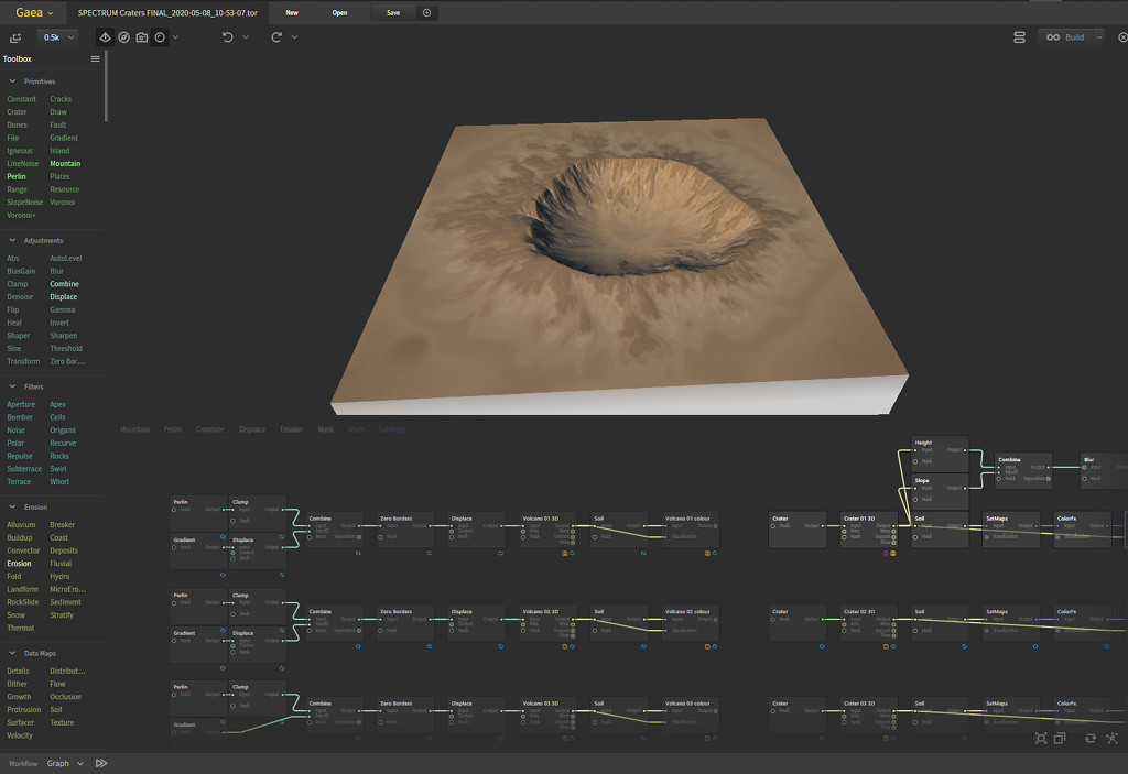
> > > Add a volcano < < <</B>
So, then of course, my challenge to the next mapper will be:
> > > > Add a Mountain Range< < < <
Next challenge: Add a river
Next challenge: Add a swamp or marsh to the map.
Next challenge will be:
> > > > Add Scrubland to the map< < < <</b>
Next challenge - forest
My challenge to the next mapper is:
> > > Add another island to the map < < <
My challenge to the next mapper is:
Add some kind of structure to the little island
My challenge to the next mapper is:
Add a natural feature to the big island.
My challenge to the next mapper is:
Add a road to the natural feature on the big island
Edit: you guys can chance the position of the legends.
And thanks for the info, Monsen -- the forest certainly looks hand-crafted and worth the effort.
Challenge: place the farmland that feeds Greenwall and supplies its traders.