

Drawing tool macros
 Loopysue
ProFantasy 🖼️ 39 images Cartographer
Loopysue
ProFantasy 🖼️ 39 images Cartographer
I am thoroughly muddled up with drawing tool macros, but willing to keep trying.
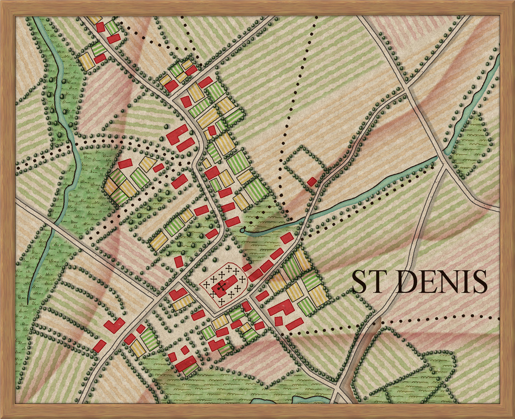
My current project is creating the Ferraris style annual issue. The fills and symbols I know how to do, and they're coming on fine, but what I can't figure out is how to make a few rather specific drawing tools - if they are even possible. Here is a list of what I would like them to do, under an image of the example map so far (to give an idea of how they would be applied).
[Image_13385]
- Draw a polygon with a bitmap fill that is aligned to the first side. This is to make drawing the stripy fields a lot easier.
- Automatically draw a filled circle on a different sheet to the line that is exactly the same diameter as the line width. This is to join different types of road that are on different sheets with both sheets having glow effects that will show as lines across roads at the point where they join. An example of what I mean by the circle is the way the roads are drawn by the random city generator.
- Automatically select random bushes or trees and do the symbols along line job on the line the user is drawing right at that moment with the drawing tool. This would help greatly with drawing the lines of trees and bushes. Maybe this needs to be some kind of connecting symbol instead, but I don't know how to do it so that the connecting symbols stay the right way up no matter what direction the line goes in - trees with trunks to the ground etc. When I draw the trees properly so that they have tiny little shadow lines it will also be important that they are sorted once drawn in a way similar to the sort symbols in map tool does it.

Comments
There are several solutions to this, but the one I'm looking at first is one that I know must be possible because its how the roads are drawn by the random city generator - to put a circle of the same fill on top of them both on a sheet with no effects whatsoever. It hides the join. This is what I have done by hand on the left, leaving the one on the right as it appears without the circle.
What I am thinking of is a drawing tool that will do this automatically.
Doing the whole thing by hand is fine (I did the example map entirely by hand because I couldn't figure out the drawing tool macros), but it is definitely a little clunky.
I don't even know if what I want is possible. Been trying for nearly a week now between textures, and I still can't figure out the first one. I think I have a basic concept problem. If I could work out how to think about macros maybe I would do a bit better.
I don't think the first one is doable using a macro until the next CC3+ update.
For the second one, drawing a circle the same width as the road is tricky if the road can have any width, but if you have drawing tools with fixed widths (which city road drawings tools usually are anyway), it should be doable. Likewise, making a copy of the road, move it a few units, and change fill is also doable in a macro, what I worry about here is getting the direction right since that seems to depend on the direction of the road.
For the third one, it can be mostly automated with Symbols Along (will probably need a dedicated symbol catalog too, bu that is easy enough), but the ESCM command don't allow the line to be selected by the macro, so the user would have to click on it after drawing it.
Thanks Remy!
Ah, well that might be some of why I can't get the first one to work.
On the second one the roads will be set widths in the drawing tools (different widths for different kinds of road), and the existing shadow is a shadow effect on that Particular sheet. The original map is inconsistent because the shading was never intended to be a shadow, but just a second line that was one side or other of the road. Shadow or shifted duplicate is as close as we can come I guess. If this is just too messy and awkward I have considered putting all the roads on the same sheet with the shadow and making the only difference be the width of the road. That will be close enough to the original for most people. I will probably upset the purists, though!
I had really big doubts about whether the third one could be done, or it would probably have been done before now. Would users get used to the idea of having to click it again after drawing it? I know I would, but that's just me.
I'm so sorry - all this technical stuff fascinates me, even though I'm absolutely crap at understanding it all.
I made the line style in the FCT while I was making the map, so I assume that when I've finished and duplicate the FCT and take all the drawn bits out of it except the frame and the screen the line style will stay with the template.
Now, if I put all the roads on one sheet but make separate drawing tools for each of the two types of road, I can have each drawing tool add the necessary lines to one of two backing sheets - only one of which will cast a shadow.
That means there are no strange circles, and I can clone one of the wall tools to make both the new road tools.
Roads will only be a pain for the user if the user decides to adjust it's shape.
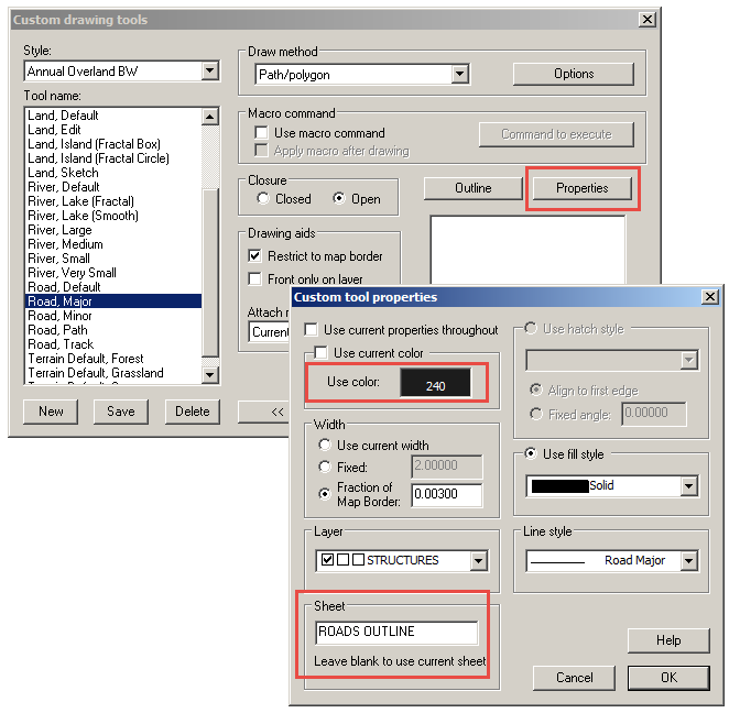
There's an easy — but unintuitive — solution to the road problem, no macros needed. Don't use outlines (or glows); use two entities in the drawing tool settings. There are similar roads in CA20 Overland Black & White issue of Volume 2 (2008) of the Cartographer's Annual.
The "outline" is actually a thicker, darker line on a sheet below the lighter, thinner line (e.g., a Roads Outline sheet and a Roads sheet). The darker "outlines" are always below the lighter "roads" and so when two roads cross, the "outlines" cross below where the two "roads" cross. There is no outline to cross over the first road and thus the intersections are clean. In CA20, the lighter road is set up using the Outline properties and the darker "outline" is set up using the main Properties. I'm not sure how important that is since they go on different sheets, but that's how it's set up in CA20. Regardless, I believe this is Ralf's genius idea (he'll correct me if I'm wrong) and it works beautifully.
As for the two road types (if I understand the issue there), you can make two tools that use different outline sheets, one with a shadow effect and one without (e.g., Roads Outline, Shadow and Roads Outline). I think that would work.
Here are the settings for a Major Road in the CA20 annual. They probably need to be tweaked since I'm sure the scales are very different but this should put you on the right... track. *rimshot*
(If desired, click each image for a full-size version)
This trick also works if you make a tool for a market square (or circle or poly or whatever shape), and works nicely for rivers and lakes, too. These also use the "two-entities & two-sheets" trick but, for the poly tools (e.g. market square), the settings are a little different. The "outline" width is a fraction of the map border just like the road outline, but the "market square" itself has a fixed width of 0.00 (so it's a filled poly).
And with those lovely illustrations I can't really go in the wrong direction.
Thank you very much, Dogtag
It's great seeing you around the place again
I'm looking at the last one now. I would like to make the hedgerows relatively automatic to draw using a drawing tool.
Close examination of the original map has revealed that there is a kind of green line underneath the bushes in a hedgerow, so I've started a tool that draws a thick green line on an appropriate sheet, but I can't seem to get it to ask me to click a line or enter anything to put the bushes along it. This is what I've got so far. Please don't laugh. My brain doesn't function very well where macros are concerned.
SELSAVE
SELBYP
ESCM xyPath
SELREST
I know! I know! It's pathetic
So the only one I picked from the list of macros that comes with the Tome is the ESCM command. Unfortunately that one doesn't work right now in this context.
So what I've done is make a drawing tool to draw the green line background and called it hedgerow background. It's not too difficult for people to then use the symbols along tool to automatically add the hedgerow on top of it.
[Image_13417]
Things that I simply can't do from inside a drawing tool macro at the moment may one day be possible, but I can't say any more than that because I'm not part of the development team.
Or, of course, this could be a great opportunity for Ralf to include information about the Symbols Along (ESC) function in the mapping guide.
This is one of them. (The gap underneath is the other half of the png below the centre point)
[Image_13420]
I used Symbols along to redraw the hedges in the example map so that it would look like the maps that users would draw using the same technique.
[Image_13421]
While the effect is to have much more densely packed hedgerows, the style of this particular extract is more sparse than other parts of the map, where the hedgerows look a lot like this. Would that work with a closed poly with a line width?
If I had a tool that drew a poly on one sheet, but I wanted that poly copied onto no less than 5 other sheets simultaneously, would this be possible using a macro?
The reason I ask is because I have this idea for a new style that depends very much on being able to easily draw a land-shaped hole through 5 sheets of ocean without getting into all the complexities of copying it across one sheet at a time by hand.
This is the map so far - a doodle just to get the effects heading in the right direction. The land shades are all in the background. That's how I've got them to behave in a way that doesn't depend on the coastline. But to do this with drawing tools I would need a macro that put the same Colour Key shape on all 5 ocean sheets at the same time.
Of course, you can't save the original selection of sheets, so we have to just show all sheets at the end, which have the side effect that any sheets previously hidden now shows.
The macro to do this would be:
RDOFF
SELSAVE
SELBYP
HIDESHTF *
SHOWSHTF OCEAN*
COPYVIS
SHOWSHTF *
SELREST
RDON
(For this example, all the sheets involved in the operation, both the sheet you draw the entity on and the sheets you copy them to should be called OCEAN something, and no other sheets in the drawing should have OCEAN as a prefix)
Editing this entity would be a nightmare though, since you would need to update all 5 copies.
That's fantastic. It should do exactly what I need it to do.
I'll try it out and let you know how it worked.