

First crack at an overland map. Would appreciate feedback
 Solo4114
Newcomer
Solo4114
Newcomer
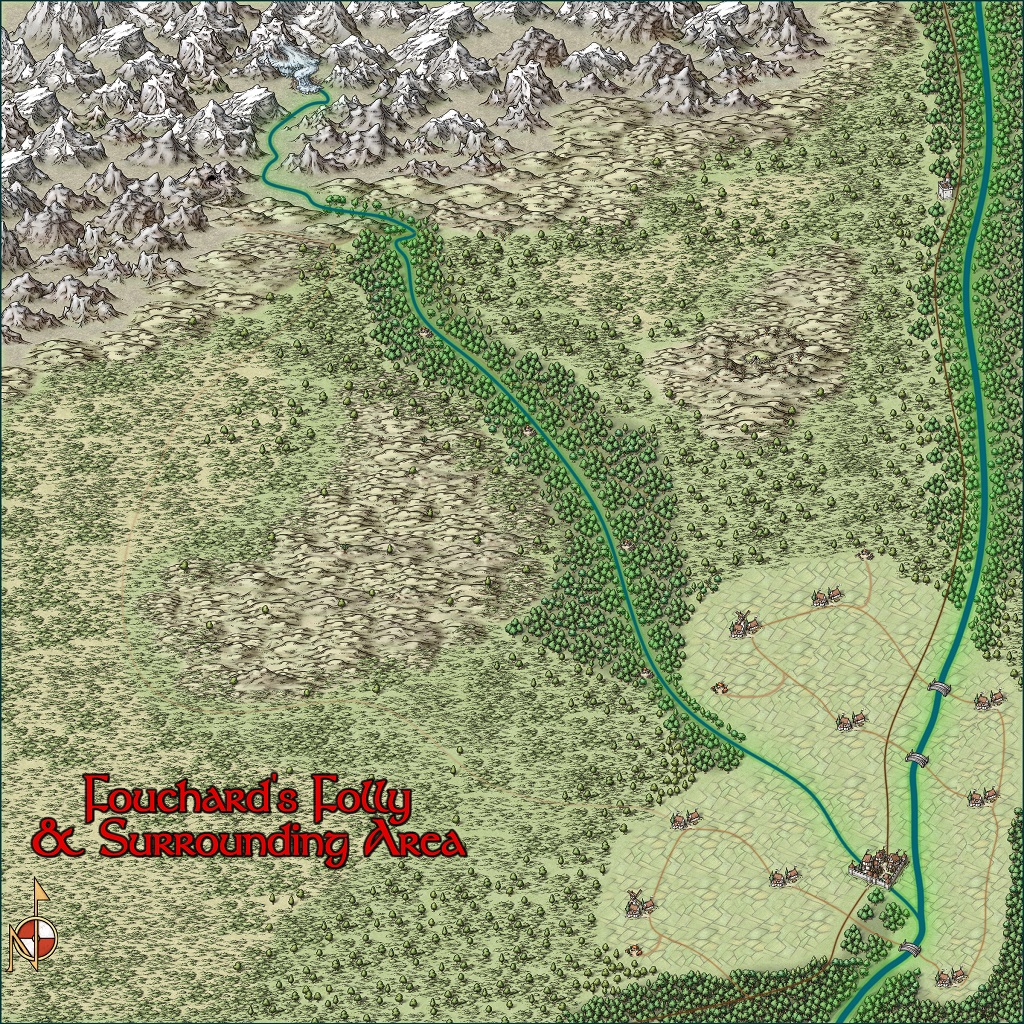
So, I bought the software a couple of months ago, and have been tinkering with it here and there. This is my first attempt at an overland map, which taught my several helpful tips. The map itself is based on an actual area -- a roughly 40mi x 40mi region near Columbus, MT (but rotated 90 degrees clockwise on the compass). I'm still getting the hang of the software, but I'd love to hear folks' suggestions on how to improve the map.
The basic background is that this will be the overland map for the campaign I'll be running (also my first time DMing) in D&D 5e. The PCs start at level 1, and the adventure should take them up to about level 4. The PCs are an adventuring company hired by a local lord to find the source of, and put an end to, raids that have been happening on the merchant caravans that run southward to the town, and on the town's outlying settlements. There are a couple of red herrings to draw the players' attention.
The basic background is that this will be the overland map for the campaign I'll be running (also my first time DMing) in D&D 5e. The PCs start at level 1, and the adventure should take them up to about level 4. The PCs are an adventuring company hired by a local lord to find the source of, and put an end to, raids that have been happening on the merchant caravans that run southward to the town, and on the town's outlying settlements. There are a couple of red herrings to draw the players' attention.
Comments
Ah, ok. Give me just a minute...
--EDIT--
Hope I did that right.
I can also try uploading a larger version of the map. I resized to fit the screen here and some of the detail gets lost.
Looks like you had a lot of fun doing this map. Nice first map
I think, if I did it over again, I'd probably either try to find a different symbol set for some stuff, or try to make the map a little less "busy" in the visuals. I'm working with a scale that seemed not entirely suited to the scale of the symbols, which I think resulted in a somewhat more visually cluttered map than would be ideal. But the other option was to not use the symbols at all, or to use them in a way that makes them look much more like a "tile" of sorts, rather than something more organic to the map.
Guess I may need to invest in some annuals and/or download some additional symbol sets.
The Mike Schley style that comes with CC3 is one of the largest overland sets there is, and I don't think there are any additional overland fills and symbols made by Mike in the Profantasy product line. There are several sources of battle map scale symbol sets, but these are for mapping things the size of a house or a cave and top view.
Mixing styles is always fun, but you have to be really careful you don't just end up with a mess caused by trying to mix styles that don't really go with each other. If you go that way then be aware of the overall colour scheme and line style you are trying to match with the MS style.
If you want to stick with the MS style but make a map that is more diverse than this one I would suggest starting an entire country. There's a lot more variety in something the size of a country. You can have coastlines, valleys, forests, plains, hills and mountains - with options to add things as diverse as standing stones and mountains with sage towers on them and all sorts of other stuff I'm sure you've seen as you scroll down through the symbol catalogue.
The map fits in as part of a campaign I'm doing. My instinct was "Start small, then expand." So, I figured I'd start with a rough sense of the overland map for this adventure, and I'll build other regions as necessary. Actually, for fun, here's the original version of the map that I made in MS Paint just to rough out what I wanted the thing to be. This was the starting point, just for my own personal reference, and from there, I decided to build it in CC3+!
When I finish with the few dungeon maps I'm doing for the same adventure, I'll post those, too. Basically, there's only two of them, but you can probably guess where they are.
You may want to move the symbols sheet with the trees on so the trees lie above the river lines, rather than behind them as at present.
I'd also be inclined to reduce the blur effect on the western trail, as I found it very difficult to follow in places even on the larger version. That's fine for keeping the players guessing, but the GM needs to know where everything is!
Minor points though, and a great looking first map!
The vegetation in the scrublands is mostly just there because...I dunno...it looked kinda empty without it, and I wanted the map to have some texture. I'm not sure how to describe the scale, other than to say that the map is a 40 mile x 40 mile map. But yeah, I could string some creeks through there to feed some of that vegetation more.
On the trees lying above the river lines, I thought I'd actually done that already. Looks like I didn't! That shouldn't be too hard to fix, though.
There's actually two "hidden" trails, both of which are blurred pretty well. There's the western trail leading up to the mine. There's also another one that runs on the east side of the river that runs down from the mine. The blur is meant to indicate that the players may be able to find the trail, but it's fairly overgrown due to disuse over the years. The eastern trail is more of a game trail than a true used trail. The western one is the remnants of the road used to get up to the mine from the town.
This is also the players' map. I have another copy with numbers on the map to correspond to encounter locations, but I could probably stand to highlight the trails a bit more clearly for other DMs to use (if anyone ever ends up using this map besides me...).
One thing I had trouble with was laying down a scale marker and then labeling it with numbers. I'd put that over by the cartouche if I could figure out how to do it so the numbers line up properly.
These are calibrated so that when you use the default symbol scale of 1 they should be the right size to cover a specified number of miles.
If the scale bar doesn't come with labels already intact, switch on the snap function of the map before you place the scale bar, and then use the snap grid to align the labels for it above either end of the scale bar.
And here I thought I was done with this map...
I very much like it, though, how the river is fed by the glacier!