

FR Gray Vale Intepretation BW Annual Template

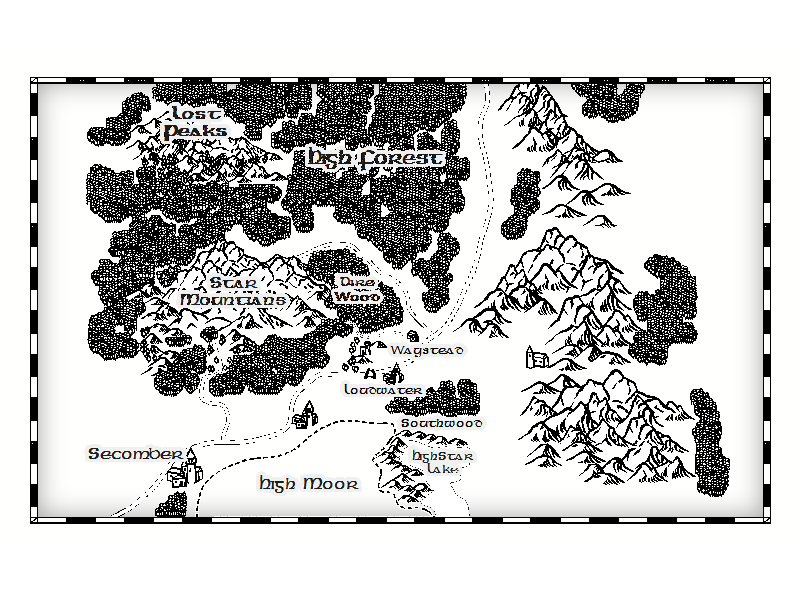
Hi All. I did this awhile ago for a campaign I will be running for my old D&D group which has come back together. This is based off of the published Forgotten Realms Map 4e that comes with the Campaign Guide. It is almost complete, I need to tweek it some and move some mountains around a bit more for a more balanced and pleasing look (suggestions welcome). I used the BW Annual Template from a few issues ago just to see what I could do without needing to customize new drawing tools.
This is a work in progress, might finish it up today... and repost again, but I am generally happy with the way it looks as a BW Handout map. I see this as an interpretation of the FR map... I don't claim any rights to the content as being unique except for a small village/town that I am using as a story 'piece' and it is called (village) Waystead at the moment. Also, I intentionally did NOT over populate this map with too many details... leaves it open for "question" from the players perspective and its good to have 'whitespace' sometimes.
This is a work in progress, might finish it up today... and repost again, but I am generally happy with the way it looks as a BW Handout map. I see this as an interpretation of the FR map... I don't claim any rights to the content as being unique except for a small village/town that I am using as a story 'piece' and it is called (village) Waystead at the moment. Also, I intentionally did NOT over populate this map with too many details... leaves it open for "question" from the players perspective and its good to have 'whitespace' sometimes.
Comments
Personally, I'd put on a scale bar, or a Distance Bar (You can go x distance on good roads in good weather) even if it's not IC. I find it helps me to envisage a world.
I'd also tweak the letters on the town below Waystead. I think it says Lotrowater, but I want to be sure of what I am reading.
A few outlying trees would break up the rather vertical forest-shapes to the right.
These are all small things, though. I think in general the balance is pleasing.