New Project - Lake-Town

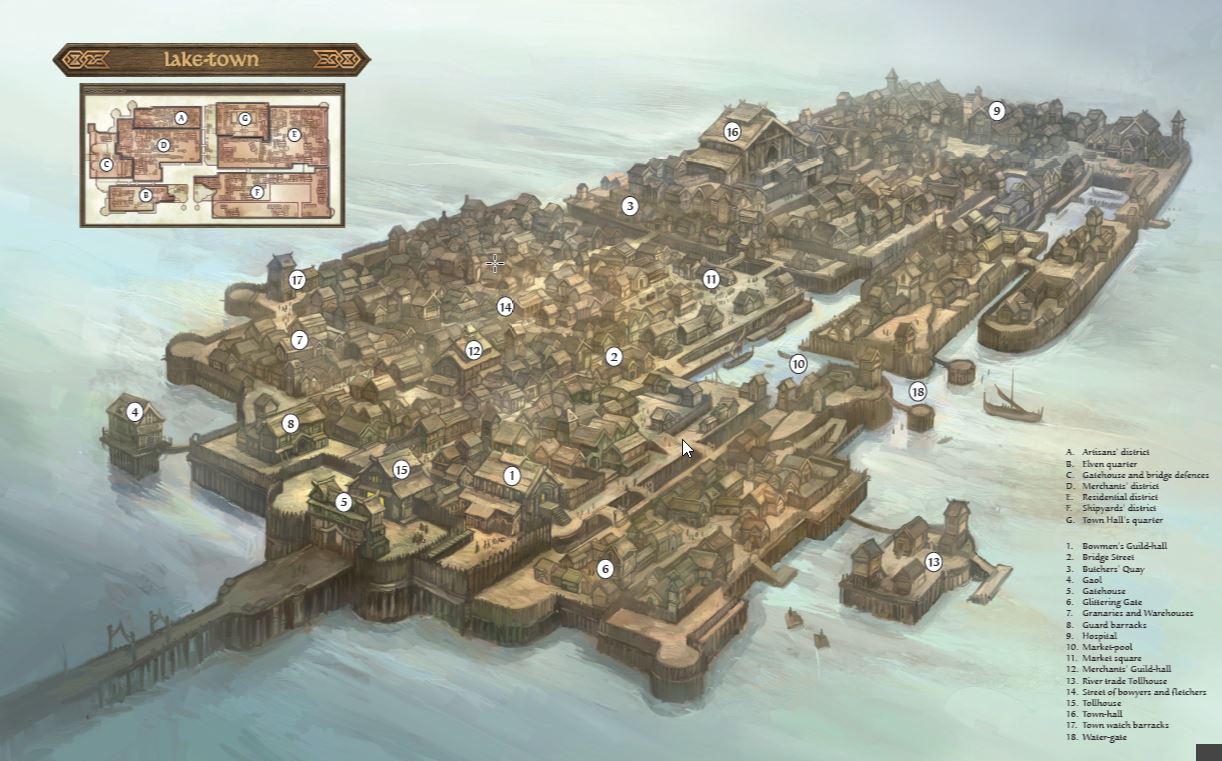
So I'm going to start a new project today. I want to have a top-down detailed map of Lake-town for my Adventures in Middle Earth game two weeks from now. I'm going to start by scaling & tracing the keyplan on the attached image and go to town (pun fully intended.) My question to you all is - any thoughts on a good style? My initial thought would be CC3 City Basic but I thought about picking up an old annual to dive into as well (I only currently own 2018 and this years stuff so far.)

Any favorites? or "Hey! XXXX would be great for that!"

As always - I appreciate all your comments.
Curt
«1

Comments

  • LoopysueLoopysue ProFantasy 🖼️ 39 images Cartographer
    The basic city styles are good, but if you want to be able to include greater variety you could always mix them with buildings created using the House command. In City designer this is the button with the house at the top on the left hand menu. Click options button once the dialog has opened and you will see that it is possible to create your own House styles - using your own fills if you wish :)

    I would play around with it on a test map for a while first - once you create a house it's really difficult to edit it, so get good with the tool first before you start on your map ;)
  • clithgowclithgow Traveler
    edited February 2019
    Thanks Sue - I'll try it out. I think I have messed with it a bit on my Rowanhold map - but I'll definitely revisit it.

    Edit - Now that I look back at it I don't think I ever put any of those custom houses into that map - but I remember playing with the tool.
  • LoopysueLoopysue ProFantasy 🖼️ 39 images Cartographer
    If you have access to a whole load of roof fills you can make a huge variety of different houses, but there are limitations. The obvious one that keeps cropping up over on the CC3 Group FB page is that you can't make automatic buildings with holes in the middle (stadiums - I've been asked how to do one of those twice now), but what you can't do with the House command you can usually make with Shaded Polygons.

    For the more elabrate rooftops that don't exist in the CD3 styles and can't be done either by using the House command or by using Shaded Polygons you may have to look to the annuals - yes.
  • I think the Vintyri collection will go along way to having varied buildings - then I'll use the House command for the special buildings.
  • LoopysueLoopysue ProFantasy 🖼️ 39 images Cartographer
    LOL! Oh yes - of course.

    I had quite forgotten them ;)
  • clithgowclithgow Traveler
    edited February 2019
    Any thoughts on a good way to do the pallisade? I rather like how the pallisade symbol from the CSUAC looks when zoomed in on a portion (I imagine outputting each district to an 11x17) but it gets a bit lost when zoomed out (I'd like to do a 24x36 output for that.)

    Sure would be nice to do a tool for that...I wonder about a open path with a bitmap fill of log tops. Then again maybe I should do it more diagrammatic with less realistic textures. hmmmm......
  • Well I did find out that if I actually let it render, rather than just taking a screenshot of the client, makes the full zoom version looks pretty good. That being said, the pallisade symbol I'm using doesn't appear to have enough short section to work for so I'm still on the hunt for another wood stake wall option.
  • You can overlap them - I have in a number of maps. They are pretty good that way.
  • clithgowclithgow Traveler
    edited February 2019
    Thanks Quenten...I actually have done that along most of the path so far to make it work...then I ran across this short run where the basic length would overshoot the corner....I suppose I could just adjust the map section there and make it the opening to a ramp down, rather than rigidly following the source material.
    gap.jpg 174.4K
  • You can also EXPLODE the symbol, remove what pieces you want off it - and even save it as a symbol in its own right (though not necessary if only neede for a few things and/or you want to share the FCW with others using ProFantasy and free addons only, eg the Community Atlas - hint, hint.
  • Unfortunately the EXPLODE doesn't do much here for that symbol since is basically just a .png file. I'll keep that in mind for other things. Maybe I'll look into the Tome on symbol making and see what I can accomplish in GIMP.

    I just looked at the community atlas for the first time yesterday. Neat setup! I'll look into the submission guidelines soon.

    Thanks again Quenten!
  • In progress shot of one of the districts. I spend alot of time hemming & hawing before actually doing anything. I think I'd like to do a different color for the building for each of the districts...but i'm not sold on this style. Will play around more I'm sure.
  • LoopysueLoopysue ProFantasy 🖼️ 39 images Cartographer
    edited February 2019
    Coming on really nicely :)

    Part of the pleasure of map making is all the hemming and hawing, followed by all the changes of mind and re-drawing - all with the aim of getting things as close to the ideal as possible :D
  • 14 days later
  • clithgowclithgow Traveler
    Another progress shot. I think this is the level of detail I'll leave the district zooms at; although I might put some more terrain blobs beneath the building to break up the ground field a bit.

    Now all I need to do is 6 more districts! Although I suppose they'll go quicker now that I'm done messing around with *most* of the decisions.
  • LoopysueLoopysue ProFantasy 🖼️ 39 images Cartographer
    I can see you really like the bright colours :)

    Curiously enough, I rather like that green in combination with the golden yellow ;)
  • clithgowclithgow Traveler
    I'll tone down those colors overtime...they just were easy to get to with the RGB Matrix presets.

    Here's the next thing I want to try. When I do my individual district zooms on this map I want to try to blur out the surrounding area. I created a "Mask" sheet with a multi-poly shape on it, basically covering the entire map with a hole cut out for this particular district. I filled it with a solid black hatch and applied a transparency & blur sheet effects. The result is below.

    I feel I'm on the right track but I don't quite like how it tints what it covers, I'd really like it to just blur everything *below* the mask without affecting the colors.
  • MonsenMonsen Administrator 🖼️ 46 images Cartographer
    edited March 2019
    Interesting question, never thought about that need.

    I can't think of a way of doing that with a single sheet, but I did manage it using 2 sheets

    Both sheets contain the same identical solid black polygon
    Both sheets contain the Blend Mode effect, both set to negate
    The last sheet in the sheet order (of the two) also contains a blur effect (after blend mode in the list) with the appropriate blur setting

    No other effects where used.

    Edit: Seems like it is doable with one sheet the same way if you set the opacity value of the blend mode effect to 0%
    x.PNG 871.2K
  • clithgowclithgow Traveler
    Thanks Monsen! That's exactly the effect I was hoping for. Check it out in the original district and the one I have in progress (those house rows are *way* preliminary.)
  • LoopysueLoopysue ProFantasy 🖼️ 39 images Cartographer
    An interesting effect, though I wouldn't bother labelling the bits you've blurred. Labels attract attention to the thing they are naming, so if you label something that is blurred it feels uncomfortable not being able to see it properly ;)
  • clithgowclithgow Traveler
    edited March 2019
    Well...Considering the game is tomorrow here are the finished (ha!) maps.

    The overall map won't see the table, but I wanted to show you where they all came from.
    Sue, I agree, the labels on the blurred out areas is distracting. When (if) I go back and tweak I'd like to try to add better titles & legends, and maybe a border. On that note I've got *lots* of messy-ness behind the scenes in my layers & sheets - I should probably tidy all that up too.

    My next thing will be to research the auto floorplan tool. I'd love to setup a template so that I get wood floors & walls by default rather than stone.

    Ran out of patience trying to re-size the shots. Check 'em out at the link if you're interested.

    Here is a google album

    Thanks for all your comments.
    -Curt
  • LoopysueLoopysue ProFantasy 🖼️ 39 images Cartographer
    Autumn's right - they do look great :)

    Don't be so quick to do yourself down ;)
  • clithgowclithgow Traveler
    Thanks Autumn, Sue!

    Its not so much that I'm down on myself, I do feel they turned out good. I'm sure like a lot of people who undertake creative projects its just that there is so often a gap between their initial vision and the final product that time and patience allows for. I'll always keep working for that, "this turned out better than I thought it would!" project. There are just so many more, "I'm gonna come back and finish this someday!" projects ;)

    I've attached one of the downsized photos here.
  • LoopysueLoopysue ProFantasy 🖼️ 39 images Cartographer
    You have actually done a really great job in a very short amount of time. Cities DO take time - usually a month or more, even when nothing goes wrong and you don't have to down tools to learn something new... unless you happen to be Quenten, of course ;)
  • clithgowclithgow Traveler
    Thanks Sue & Quenten - That means alot coming from you two!
  • If I may ask, if the symbols and fills are all from CC3 products (and not your own, or other resources from elsewhere) is there any chance this can be put in the Atlas. I can suggest placements if you are willing.
  • clithgowclithgow Traveler
    Absolutely Quenten! I didn't use any custom symbols or fills beyond CSUAC/Bogie/Dundjinni archives to the best of my recollection. I've not read the submission guidelines very thoroughly but I will tonight - feel free to summarize though ;) And I would happily have it placed on any area you suggest.

    My only thought is that the various district views/outputs rely on turning on and off specific layers to show & hide the masking objects to create the blurring effect and hide the reference lines I use for zooming. Not sure how that might affect any submissions - but you are welcome to the .fcw files and I'll happily output any images/pdfs that you might want. Let me know what you think and I will read through the guide lines tonight.
  • Remy Monsen automatically fixes that with toggle on and off buttons at the side of the maps. If they are as you say, then why not submit it to Remy ASAP. I will give a list of good options in next 15 mins or so. This city is a piece of art.
  • clithgowclithgow Traveler
    *Blush* Thanks again Quenten, that"s very kind and encouraging. I look forward to your suggestions and will definitely submit tomorrow when I can give it a write-up, particularly on which layers to show for which named view.
Sign In or Register to comment.