

Community Atlas - Kentoria - Sophos region
![[Deleted User]](https://secure.gravatar.com/avatar/c75d9a245b74d9c59be0999ea81ca541/?default=https%3A%2F%2Fvanillicon.com%2F92add7f8c954488718110edc4896ad39_200.png&rating=g&size=200)
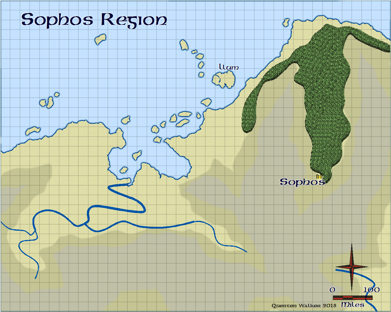
Here is the beginning of the Sophos Region of Kentoria, a continent sadly neglected. I am using the Pete Fenlon style, from Annual No 2 (issue 13). It will also contain the Isle of Llum when finished.
Comments
Looking forward to it
Here is the Island from Google maps
Kotelny Island
Kotelny Island is part of the Anzhu Islands subgroup of the New Siberian Islands located between the Laptev Sea and the East Siberian Sea in the Russian Arctic. It is administratively and municipally part of Bulunsky. District Kotelny, Faddeyevsky and Bunge Land are usually named as separate islands on most 20th century maps, although sometimes on the newest maps the name "Kotelny" is applied to the whole island. A flat, low-lying, plain connecting both is known as Bunge Land (Russian: Земля Бунге).
The total area of Kotelny Island is 23,165 km². Kotelny is one of the 50 largest islands in the world. These merged islands are a practically uninhabited territory belonging to the Sakha Republic (Yakutia) of the Russian Federation.
History
The island was officially discovered by a Russian merchant and hunter, Ivan Lyakhov, with the merchant Protod’yakonov, in 1773. In 1770, Ivan Lyakhov noticed reindeer tracks heading seaward across the sea ice. In 1773, he and Protod’yakonov discovered the Lyakhovsky Islands by boat using the bearing of these tracks. Continuing from the Lyakhovsky Islands, they discovered Kotelny Island and named it "Kettle Island" after a copper kettle, which they found while exploring it. The person(s), who visited Kotelny Island and left the copper kettle, is unknown. Formerly this island had been known as "Thaddeus Island" or "Thaddeus Islands" in some maps.
Under the employment of Semen and Lev Syrovatskiy, Yakov Sannikov conducted numerous hunting and cartographic expeditions between 1800 and 1810. On one of these expeditions in 1805, he discovered Faddeyevsky Island. In 1809–1810 Yakov Sannikov and Matvei Gedenschtrom went to the New Siberian Islands on a cartographic expedition. Yakov Sannikov reported the sighting of a "new land" north of Kotelny in 1811. This became the myth of Zemlya Sannikova or "Sannikov Land".
In 1886 Baron Eduard Von Toll thought that he had seen an unknown land north of Kotelny. He guessed that this was the so-called "Zemlya Sannikova".
Geography
The western part of Kotelny Island proper, also known as "Kettle Island", is the largest section of the group, with an area of 11,665 km². It is rocky and hilly, rising to 374 m on Mt. Malakatyn-Tas. The Chukochya River flows westwards to the Laptev Sea. Cape Anisy 76.200°N 139.1167°E is the northernmost headland of Kotelny and it is an important geographical point for it marks the NE limit of the Laptev Sea. Cape Medvezhiyis the southernmost headland of the island.
Bunge Land or Zemlya Bunge is a huge empty and almost barren intermediate zone. It is located between Kotelny and Faddeyevsky, which, unlike Bunge Land, could be described as proper islands. Sandy and flat, its area is 6,200 km². Since it rises only to a maximum height of 8 m above sea level, Bunge Land is flooded during storm surges, except for a very small area in the southeast that rises to an elevation of 11 to 21 m above sea level. The area that is periodically submerged accounts for over 80% of the total surface and is practically devoid of vegetation. Bunge Land is named after Russian zoologist and explorer Alexander Alexandrovich Bunge.
Faddeyevsky Peninsula (полуостров Фаддеевский) is a large peninsula projecting from the northern end of Bunge Land eastwards with its isthmus in the north. There is a deep inlet on Faddeyevski between its western coast and adjoining Bunge Land. Unlike Kotelny this island is relatively flat despite its size, its highest point being only 65 m. Its area is 5,300 km². Faddeyevsky is covered with tundra vegetation and dotted with small lakes. This island was named after a fur trader called Faddeyev who built the first habitation there.
Location of the Faddeyevsky Peninsula in the Anzhu subgroup.
Adjacent islands
• Deep inside the bay on the northern side of Kotelny lies Skrytyy Island. It is 11 km long and 5.5 km wide.
• Very close to Bunge Land's northwestern coast there are two islands: Zheleznyakov Island , right off the NW cape and, east of it, Matar Island. Both islands are about 5 km in length.
• Nanosnyy Island is a small island located due north off the northern bay formed by Kotelny and Bunge. It is C-shaped and only 4 km in length, but its importance lies in the fact that it is the northernmost island of the New Siberian group.
• Figurina Island was located about 30 km east of Nanosnyy Island. When discovered in 1822 by P. Anzhu, while he was searching for "Sannikov Land", its area was about 8 to 9 km². At that time, it had sea cliffs as high as 20 m (66 ft). Although marked on maps published in 1926, 1941, and 1945, a Soviet hydrographic expedition conducted in the early 1940s found that Figurina Island no longer existed.
Geology
Kotelny Island consists of sedimentary rocks and sediments ranging in age from Early Paleozoic to Late Cenozoic. The oldest rocks fossiliferous shallow- to deep-water marine, Ordovician to Early Devonian limestones and dolomites. Middle Devonian to Carboniferousinterbedded limestones, dolomites, sandstones, and conglomerates overlie these sedimentary strata. The Permian to Jurassic strata exposed within Kotelny Island consist of interbedded, fossiliferous mudstones, siltstones, and sandstones. All of these sedimentary rocks are faulted, folded into complex anticlines and synclines, and intruded by thin diabase dikes. Pleistocene to Holocene fluvial sediments, which range in age from 1,500 to greater than 55,000 radiocarbon years BP, underlie stream terraces that lie within the Balyktakh and Dragotsennaya River valleys. Thick permafrost has developed in these sediments.
Within Bunge Land and the southwest corner of Kotelny Island, relatively unconsolidated sediments ranging in age from Early Cretaceous to Holocene overlie the above folded and faulted sedimentary rocks. The oldest of these sediments are Early Cretaceous alluvialclays, silts, and sands that contain layers of conglomerate, tuff, tuffaceous sandstone, coal, and, at top, rhyolite. The Late Cretaceous sediments are overlain by Late Eocene to Pliocene alluvial sands that contain layers of clay, silt, gravel, brown coal, and lignitized wood. The vast majority of Bunge Land is blanketed by Early Holocene marine sediments. Only in the central and southern parts of Bunge Land do either Late to Early Pleistocene marine sediments or very small patches of highly weathered Prequaternary deposits and bedrock underlie the surface.
The surface of Faddeyevsky Island is underlain by unconsolidated sediments ranging in age from Early Cretaceous to Pleistocene. Three very small and isolated exposures indicate that the Early Cretaceous strata are similar to those found in the southwest corner of Kotelny Island. Overlying the Early Cretaceous sediments are alluvial and lacustrine Eocene clays and silts that contains rare beds of sands, brown coal, and gravel. To the north these sediments grade laterally into nearshore marine clays with fossil pelecypods. The Eocene sediments are overlain by fossiliferous, terrestrial and marine Oligocene to Miocene sands that contain subordinate beds of mud, clay, gravel, and brown coal. The Oligocene-Miocene sands accumulated in alluvial, lacustrine, and nearshore marine environments. Overlying the Oligocene-Miocene sands are Pliocene alluvial, lacustrine, and nearshore marine, muds, silts, and sands.
Pleistocene deposits blanket most of the surface of Faddeyevsky Island. A layer of Late Pleistocene and Holocene alluvial and lacustrine deposits largely cover the central and southern parts of Faddeyevsky Island. Middle and Late Pleistocene deposits largely cover the northern part of this island. The permafrost is about 400 to 500 m thick. The central plain of Faddeyevsky Island has been highly altered by thermokarst processes. It contains numerous deep erosive cuts created by the seasonal melting of the permafrost. Numerous baydzharakhs, thermokarst mounds, dot the landscape; they are the result of the melting of polygonal ice wedges within the permafrost.
Vegetation
Rush/grass, forb, cryptogam tundra covers all of Faddeyevsky Island and most of Kotelny Island. It is tundra consisting mostly of very low-growing grasses, rushes, forbs, mosses, lichens, and liverworts. These plants either mostly or completely cover the surface of the ground. The soils are typically moist, fine-grained, and often hummocky.
Prostrate dwarfshrub, herb tundra covers all of Bunge Land and the eastern part of Kotelny Island adjacent to it. This type of tundra consists of dry tundra with open to patchy (20–80% cover) vegetation. The dominant plants comprising prostrate dwarfshrub, herb tundra are shrubs, i.e. Dryas spp. and Salix arctica, less than 5 cm tall, graminoids, and forbs. Lichens are also common.
Climate
Kotelny Island has a harsh arctic climate, with temperatures only reaching above freezing briefly in the short summer months.
Strategic Importance
Between 1933 and 1993, Kotelny Island hosted an important Soviet naval (Northern Fleet) base. With the fall of the Soviet Union, the base was evacuated and only a civilian arctic research station remained located on the island. In late 2013, the first steps were taken to reactivate the base, with a temporary airstrip for flying in supplies and personnel established by a Russian naval task force that visited the New Siberian Islands during September 2013. Other initial infrastructure and supplies for the base, along with associated personnel were landed by the task force, whose flagship was the Kirov class Battlecruiser Petr Velikiy.
In September 2014, the 99th Tactic Arctic Group permanently established the base by beginning construction of a runway, pier and accommodation for troops and their families.[16] The airfield is now able to receive Ilyushin Il-76 aircraft all year long which significantly improves the bases ability to re-supply.[17] The base is known as the Northern Shamrock.
In popular culture
Part of the action of Jules Verne's novel César Cascabel (1890), takes place on Kotelny Island. There the European protagonists encounter 350–400 members of a "Finnish tribe" who make their living by whaling and sealing.
Feeling young again :-)
Feel free to add suggestions/corrections till then.
I like Fenlon Style (always have, which made me so excited when it came out in the 2008 annual). i did some early maps with it, but was right at the beginning of my learning curve.
Sophos and Nerilim Region
This region northeast of the massive Great Stonewall range, has seven political entities, discussed below.
The human population mainly derives from migrating Erithians (Celtic-like people) from Caer Saes in Berenur, the continent to the west of Kentoria. They chose the regions north of the great Stone Wall, as it was an area not controlled by the Glorious Everlasting Kentorian Empire (though the latter still assumed it ruled those lands – hahaha).
Kingdom of Nerilim, (pop 100,000), ruler Queen Nimrothen (age 47).
Predominantly human with some half-elves and dwarven folk
Cities: Nimfaroth (capital) pop 15,000
Iselreth pop 10,000
Thinberas pop 9,000
The monarch’s seat is in the mighty sprawling castle of Caer Aedil, added to in many different styles over the last 459 years of the Kingdom’s history.
The main geographical features are the rich alluvial plain watered by The Tamari River and its two main tributaries, the East and West Eskior rivers. In the east of this fertile plain is the great Grimholt Marshes, teeming with medicinal herbs, tasty fowls and exotic fish and crustaceans, along with the dreaded Green Mutant Turtles, able to bite a man in half (women too, believe it or not!). The plain is broken up by grassy hill country, very suitable for grazing cattle and goats – the Kingdom makes the bst goat milk cheeses and yoghurt!
Generally a reasonably pleasant place – for a feudal system, with a strong monarchy.
Autarchy of Sophos (pop 75,000), ruler Lord Magnadir (age 138).
Predominantly human with some half-elven.
City: Sophodun (pop 8,500) – a bustling town built around a grim citadel
This is a hilly valley split almost in two by the dense forest of Taure-o-Ungo, with a largely rural population and many small villages and only one sizable town. It is watered by the swift flowing Moraril River flowing down the west side of the mountains to the sea.
Unlike Nerilim, this is not such a nice place to live, being under the rule of a very autocratic dictator, who wrested control from the now exiled ducal family 85 years ago. Magnadir is actually a powerful mage using life-extending spells. He loves dominating, and even deriding, women, and thinks he is a marvellous leader, ridiculing any who raise any objections to any of his often erratic policies. In fact, the population is falling steadily, with the majority emigrating to the Free Cantons of Mordori.
Free Cantons of Mordori (pop 35,000), ruler – Council of the Five.
Mostly human with some elves and even more half-elven.
Canton Free Towns: Aelendir (pop 3500)
Galenrion (pop 3,000)
A long thin coastal land, with Lake Ibemari, a large and very beautiful coastal lagoon, being the major feature of the western region. Additionally, it takes in a number of coastal islands.
Once a vassal of the Duchy of Sophos, it is now fiercely independent. It is divided into five cantons, each ruled by an elected Mayor by all married adults over age 30. The five form the ruling council, and developed quite a reputation for trade, banking and manufacturing timepieces.
Isle of Llum (pop 50,000), ruler Laird Ossian McTuard (age 36).
Predominately human
Capital: Mobertory (pop 4,000)
This was once the biggest Canton of Mordori (in population) but broke away within 10 years of Mordori’s independence from Sophos. It is a fiercely self-reliant country, with great loyalty to its elected Laird. The Laird is elected from among the male members of Clan Tuard by all men over age 17 of the Clan, and they reside at Caer Tuard.
[This will be further detailed in the Map of Llum.]
Fay Queen’s Realm (pop 25,000), ruler Queen Morgaridel (aged 468).
Exclusively elves except as below.
Capital: Tar-o-Mòre (pop 12,000) – a beautiful city, nested in the lee of the Gaikol Mountains and by the shores of the deep dark lake referred to as the Esgad.
A secluded Elven dominion, dedicated to protecting the forest. 80 years ago. The Queen welcomed the exiled heir to the ducal throne of Sophos 80 years ago, enabling him and his family to settle after 5 years of hunted exile. His son, Fergus MacAilen is now head of the family, and his brother, Conall, has taken up residence in a previously abandoned tower in the southern part of the Forest, and as a powerful Enchanter, is known as the Grey Enchanter. He aids the downtrodden folk of Sophos where he can do so discreetly, and to his brother’s dismay, enables them to flee Sophos for the lands of Mordori and Nerilim.
Balinak-dum (pop 35,000), ruler Thane Dundor Greybeard. (age 217)
Exclusively Dwarves.
This is a huge under-mountain realm of industrious dwarves with the impressive gates on the shores of the deep blue lake of Elberoth. They are divided into three clans, the Greybeards, the Redarms and the Blackhammers. At present the Greybeards are ascendant, but when their elderly ruler dies (which should be soon), it is likely that the Redarms will pose a serious challenge. They trade with Nerilim and Sophos equally and remain totally out of the politically tense situation.
Tribes of Baluk (pop 11,000), High Chieftain Gargush the Scarred.
Predominantly half orc, with a few werecreatures.
The tribal lands comprise the wild regions of the northern Gondirammas (Stone Wall range), and are divided into the Zil, Drak and Jeg tribes. They meet at each tribal land every year at a great fair, where they trade goods and wives. The tribes are polygamous, but treat their offspring well. They hate the dwarves and are afraid of the elves. Humans they regard indifferently. Most of the leading positions are taken by lycanthropic halforcs, usually were-goats.
Political tensions
Nerilim is concerned about the possibility of war with Sophos, and is involved with competing claims to the island of Caleb in Harshanet Bay with the Free cantons. They also are alarmed by the increasing competition from the Cantons in matters of trade and finance.
The Cantons not only have their eyes on Caleb, but also wary ones on their southern neighbour Sophos, whom they fear is planning a campaign against them, at the connivance of Nerilim. They also are still smarting over the loss of Llum, and therefore guardianship of the Holy Isle of Anio. Finally, there is friendly but serious rivalry between the five cantons, and the Council of Five is often at odds with each other. They look to the Fay Queen for aid against Sophos, and have taken in considerable numbers of asylum seekers from Sophos. Recently they have begun to detain them in designated centres till they ascertain whether any are actually terrorists under the orders of Lord Magnadir.
Llum is not sure about the intentions of the Cantons, and are very possessive of their guardianship of the isle of Anio (supposedly independent, and a site of pilgrimage from all the human realms). They look to Nerilim as their ally, and oppose the claims of the Cantons to Caleb island.
Lord Magnadir is indeed planning expansionist moves, and has a trained group of assassins, the Red-headed league, who carry out terrorist acts against the Cantons and to a lesser extent Nerilim.
Finally, the Fay Queen is trying to remain aloof, but utterly detests the usurper in Sophos, and gives covert aid to the exiled Duke’s family and the Cantons. She is disappointed in the new policy of detention of asylum seekers, and is using her alliance with the Cantons to leverage a better outcome for those she calls refugees.
The dwarves and Baluk tribes are too busy skirmishing with each other (and themselves) to care about the rest.
Llum
Sophos
Thanks for contributing.