

Elandia

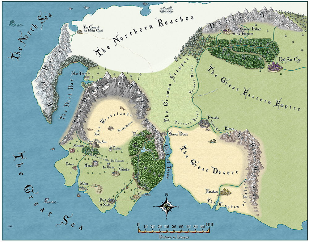
I thought I would share the first map I completed with CC3+. This was done after a couple of aborted attempts while I was learning the program. The map is for the first book in a series of epic fantasy novels I am writing. I wanted to get it done for the release of the manuscript to my beta readers. This map was completed about four days after purchasing the software. The map has a couple minor touch-ups added after it was released with the beta version of my book. The map uses the Mike Schley Overland Style. I was very pleased with the results (although I knew I could do better with scale of some of the icons and labels). My readers were quite impressed, also. I had long wanted to make a better map than the hand-drawn scribble I had used for reference while writing. I checked out many map making programs, and—after much research—chose CC3+. I am not disappointed in my choice.
I purchased Remy's tome with my initial purchase of the software, but I didn't read much of it until after I completed the map. All my effort was put into trying to meet my tight deadline for release of the beta (which coincided with a family reunion I was about to attend. The map was ready just before driving from Kentucky to Oklahoma City. Most of what I learned was by doing and searching for help when I ran into a roadblock. I also viewed some of Joe Sweeny's videos to get me pointed in the right direction.
I purchased Remy's tome with my initial purchase of the software, but I didn't read much of it until after I completed the map. All my effort was put into trying to meet my tight deadline for release of the beta (which coincided with a family reunion I was about to attend. The map was ready just before driving from Kentucky to Oklahoma City. Most of what I learned was by doing and searching for help when I ran into a roadblock. I also viewed some of Joe Sweeny's videos to get me pointed in the right direction.
Comments
One recommendation: Maybe play a bit around with the edge fade, inner sheet effect on the Sardan Yak Kaviri/Northern Reaches. I like this effect very much, but this is just my opinion.
I have some higher resolution version here: https://www.cartographersguild.com/showthread.php?t=42243 There are also some shots of the new Elandia map I am working on using the Jonathan Roberts style. It is on hold until I make some symbols for the cities. I have been waiting as I develop my drawing skills in SketchBook.
I did a hand-draw map that is over on the Cartographers Guild to work on my drawing skills. I enjoy making maps using a drawing tablet and SketchBook and I enjoy making maps with CC3+. Two different tools and some projects call for one or the other.
I wanted to share my maps here so that in some small way I can help demonstrate the capabilities of this software and inspire others. Hopefully people can learn from what I have done and the mistakes I have made along the way that will improve their own mapping making—as I have done from what others have been so generous to share. One mapmaker whose work has really inspired me is Jonathan Roberts. I really appreciate his website (http://www.fantasticmaps.com/) and the tutorials he has posted there.
I just wish I could get past that stage and actually write something! LOL!
These are great - thanks for sharing them.
mapping is creating
Jon Roberts is my favorite style and it fits my vision for what I want to accomplish best in most cases. I also really like the Mike Schley style and I like the fact it comes standard with the base program. You can make some really lovely maps with it. There are several other styles I want to try when I have the appropriate project to try them out.
To transform the hand-drawn relic to a CC3 map I imported it into CC3 as a bitmap and placed ii on the bottom of the layer stack (i.e. on top of everything else) and set transparency to about 50%. This way I could set it whenever I wanted and it would never be covered up (except for what I was working on at the moment until the map refreshed) and I could see through it to see what I had done. If I didn't want to see it, I simply turned-off the layer. I got this technique from either a YouTube video I viewed or from the Tome—I don't remember where.
I think the relative scale of different kinds of symbols might be a little discomforting. What I mean by that is that we are more familiar with seeing regional maps where all the symbols are set to the same scale as each other - usually the default scale of 1. (Yes, I know that's not a scale, because a scale ratio should be a ratio, and not a single figure, but 1 is the default size of the symbols when pasted direct from the catalogue without any fiddling around with the default size).
Maybe there is a slightly different problem going on here in this particular map though, because apart from the fact that the symbols do not appear to be of a comparable scale with each other (those forts are the size of a city in their own right), they are also apparently of different styles. I can't be certain about that last point because its been a while since I actually mapped anything., but they do seem to be a bit of a mismatch with each other. Maybe try it two different ways? Try using a strict selection of symbols from the same style as the fills mountains and trees, and on the other hand with everything as it is but the cities and forts and things shown at exactly the same scale as each other - and the same scale as the mountains and trees.
You are correct in the 1 league = 3 miles. That is the ratio I used and is the traditional interpretation of a league, though different ratios have been used historically. The map is sized like the first Elandia map, not the continent map. I understand the confusion as there has been not clear delineation in this thread between the two.
The symbols may in fact be too large. I know the village north of the Dragon Teeth is out of proportion with the village by the Spire (the lone mountain).
I regards to symbol proportions, I don't necessarily go with default size. I set them manual to match the map. In the first map, the city symbols were too small so I may have over corrected in this attempt. The symbols used are, for the most part, from the JR Overland style. The exceptions being Melekhir, which is a Schley, and Fara'Ri which is two different Schely city symbols combine with JR Overland mountains and some details like a waterfall added in SketchBook then turned into a symbol.
When I resume this map, I will most likely go with symbols I create from scratch for the cities, forts, and villages since I would like some uniqueness (the map will be included with my books when published) and none of the symbols sets have everything I desire.
Its just that you went and asked a specific question and I'm a bit of a nut about trying to answer things. Its like an OCD thing with me! :P
As for the file not showing - Its because you had an apostrophe in the filename. If you take that out the image will show.
There is a river that flows into the Green Lake from the SE that I plan to add mist around similar to the effect around the blue roof fort/city icon. I will do that in post-processing after I finish the map in CC3.
Hopefully I will get back to this map soon, but right now I'm trapped in Melekhir and they closed the gates and won't let me out.
I like your mountains. just a few more details and you can go with them I think!