

W.I.P. - Map 'The Battle for the South'

Hello everybody,
at the moment I am working on a map of the southern countries of the world where we are playing. I am doing this map to get on overview about what happened in these countries and what is the current political & religious situation. This effort is necessary, because in this independent RPG from 90's which we play these informations are distributed over several books in all kind of places. E.G. the sourcebook of the world is not done in a way we know it from D&D and others with structured information, it is rather written as a letter collection from different NPC of the world like high-priests, merchants, travellers etc which leads to a great atmosphere, but very incomplete information...
As the purpose of the map is to be a situation-map for me, it contains some text. I finished about 2/3 of the map and now I struggle a bit with a desert storm. When you look to the left bottom of the map, you can see a moon-elf (handpainted by my mother in law :-)) blowing into the desert and pushing a sand-storm. I found a storm in the CC3 symbols which is quite fine, but I would like to try additional methods.
So does anybody has an idea, how to do a sandstorm?
Thanks and kind regards, Jensen
A better resolution pdf you can get here
https://1drv.ms/b/s!Ak-JjeRFvmSPq36T3RCAVWjGvx7E
Comments
This is another very fine map, regardless, and worth examining in more detail in its enlarged version than I've had time for so far.
However, to your sandstorm question. My initial thought would be to make the storm more blurred, and perhaps even transparent (at least in places). A quick search using "orbital view sandstorm" brought up a number of images that might help. This is a small version of an event over The Gulf in May 2007 from this NASA webpage, for instance (there's another image available from that linked page as well):
[Image_11510]
It helps of course if there's something beneath the storm that can be seen still, to judge its relative transparency (hence my choice of this image).
And just out of idle curiosity, which RPG are you using?
[EDIT: Forgot to say, maybe make the storm more like the natural catastrophe illustration towards the upper left of your map, by Harfleur and the Crystal Coast.]
Indeed my plan was to make the storm in the style i‘ve made the asteroid, but I was not satisfied with the result. So i make a rest now and study the fotos you recommended, thank you!
Edit: The Gondolin map is on my to-do-list, as my daughter asks me regularly to make her a map of Beleriand. She knows the places and stories of the Hobbit and the LoTR, now I should read and map her the Silmarillion. :-)
I hope you'll make some progress with your sandstorm development. I liked the impact illustration, as it fits perfectly with the map style, yet still stands out as something unusual.
Be great to see your map of Beleriand in the fullness of time, certainly
Regarding RdW I can only give you a typical German answer: It's complicated.
RdW was never a big game, it remained in the shadows of D&D and Das schwarze Auge, but it's great because it's different. We came back to RdW because (at least I) was bored about all these RPG where you read great character class descriptions and when you look what that means in-game you find yourself with a bonus +1 on defense and an additional five foot step (as an example). Character classes at RdW are not balanced and some of them have extreme powers, like the 'Herr über den träumenden Geist' (Master over the dreaming spirit), a blind (and therefore extreme vulnerable) character class with powers I've never seen before in an RPG. And that's great, that's fantasy. Of course not everybody likes that, maybe one reason, why RdW never became big.
By the way in the forum you've mentioned (the last one that still exists) you can download the original RdW world map from 1991, but you need to register:
https://www.ruf-des-warlock.de/forum/index.php?showtopic=943
I can strongly recommend reading Tanith Lee, anytime I read her books I become a bit drunk without drinking. Her fantasy is different, strange and typical 80's style. A real contrast to contemporary fantasy. Give it a try!
Thanks too for that map link. However, I think I already found a copy of the same map, but split into four parts, among the Galerie pages of that same Forum, under Landschaften here. Annoyingly, my initial searches online kept coming back only with World of Warcraft images for their version of Tanaris...
I also added some places (islands at the top left), the light from the 'Eternal Flame' in the north of the map (a strange place in the north of Porginor) and minor stuff.
A high res version you can find here
https://1drv.ms/u/s!Ak-JjeRFvmSPrAL3k0RJsjqH2oLB
The sandstorm's looking better. Maybe make it a little more transparent, so you can still see more of the terrain demarcation line that runs across southern Gandram, west of the Beorn River/Seaway.
Speaking of which latter, that river's northern mouth (or inlet, hence my "seaway" note above) maybe needs some further tweaking, as it seems quite disjointed from the ocean just now. Or is that deliberate (some magical effect, perhaps)? The southern mouth looks good as a waterfall, so I'm guessing the general flow must be north to south.
Love that central plateau, with its wonderfully-executed edge escarpments and internal gorges. Not CC3+ though, I imagine.
There's an oddly linear terrain colour change near the eastern edge, cutting west to east across Ringar which seems unconnected to the scarp line drawn there as well, which might need some adjustment?
The river-mouthes are something I have on my to-do list, they all need to be made better. As I usually hate doing these mouthes, so I do them at the end :-). The (non-existing) waterfall from the Torgas plateau is in the same categorie...
About the strange river-flows I will say something when the map is done, then I will give an overview about the stories happening on the map, explain the religios symbols etc.. At the moment I still find additional places while reading the source books.
Everything in the map is CC3+, except the moon-elv blowing into the storm. The plateau-symbols and canyons are from the Jon Roberts or Midgard annual (I cutted them a bit).
Erendor and Ringar are still in progress. Erendor gets further places, farmland etc. Ringar has a huge crater/crevasse and some wood over it. And I need to write something about the temple there.
I much appreciate your sharp eyes, you pointed the big points I have on my list. It motivates to elaborate on them.
Edit: And the star in the 'Ashrarn' Symbol (half-moon and star) is also not from CC3+
I actually assumed the Torgas plateau river simply passed underground (which could happen if the underlying terrain were of limestone, for instance), which is why I didn't comment on it.
Thanks for the comments about the Jon Roberts and Midgard symbols being what you'd used to create the plateau effects. The canyons there are especially brilliantly done, I think. They're like images of the Grand Canyon in the USA taken from space, to me.
Of course, I like the Moon Elf illustration too, which feature I also noticed was on the original RdW game maps available via the Forum we mentioned, though presumably by a different artist. Still thinking those of us without access are missing out by not having RdW more widely available, by the way!
The canyons and cliffs from Jon Roberts I cut into small pieces which allowed me to re-assemble them to large canyons. The 2 Jon Roberts annual-issues are brilliant, I use them so often. I would be very happy if we get a third one
Regarding RdW: It‘s indeed sad, that nothing new comes, I have heared that at least two source books are ready to print since 10 years. But you can still buy the great Tanaris sourcebook (Tanaris Quellenband 1), the monster compendium (Geschöpfe der Engel) and some campaigns. As the owner of this shop owns the rights on RdW, you can ask him about future plans :-)
http://www.games-in.de/Fantasy
I think I am more or less done. There is always space for fine-tuning and I’m looking forward to recommendations, but the journey of making this map comes slowly to an end. A high res version of the map you can find here:
https://1drv.ms/u/s!Ak-JjeRFvmSPrG2KJS_fAhKViXcc
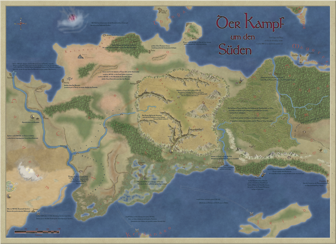
As promised, this time I will give some background information to the map. As I said, Ruf des Warlock (RdW) is roughly based on Tanith Lees ‘Flat Earth’ novels and inspired a lot by her Fantasy in general. For the first step that means, the world is flat.
RdW is mainly driven by the war of the gods, called Cherubims. They are 8: Ashrarn, Chuz, Uhlum (directly taken from Tanith Lee), Cäsar, Halphas, Thyron, Hazel and Thongmor (see their symbols at the left side of the map). These 8 Cherubims have about the same powers, but to make it easier for the people, they gave themselves some kind of a brand (Thyron for justice, Hazel for beauty …), but bottom line is, these 8 Cherubims are very similar, they are bored of being immortal and everything they can do to get some satisfaction is to fight against each other. And they do it a lot, keeping the world busy with that. They actively engage in daily things, wandering around on the world playing their games. That’s why I named the map ‘the battle for the south’ as behind these wars are the Cherubims.
Central to the map is the Torgas plateau. Several hundred years ago the ‘battle of the Torgas pass’ happened here, where an army of Thongmor defeated a huge army from the countries of Carrom and Camor (Hazel and Thyron), which lead to the total defeat and extermination of the High-Elves of Camor (see the ruins on the map). After the battle, the country of Nahor got established. Since these times the other Cherubims fight against Nahor and they already pushed Thongmor back (once Thongmor controlled the southern countries of Camor, Gandram, Carrom). So this is the broad set-up.
The world of Tanaris is full of fantastic places and I want to highlight some:
- Steinwürste des Betrugs (stone desert of deception): Once this was a fertile land. The King of this land wanted to become rich and asked Ashrarn for help. Ashrarn promised him to make him incredibly rich, if the King attacks the neighbor lands. The King started war against his neighbours but he lost the war. But nevertheless he came back to Ashrarn and asked for his reward, because he did what Ashrarn asked him for (in his opinion…). Ashrarns answer was, that he toppled stones over the whole land, ruining the whole country, making the most of the people die and so the land became the stone-desert-of-deception. Now there live only a few Ashrarn believer.
- Kloster von Chorazon (Monastery of Chorazon): Home of Hazel-believing female warriors (the character-class ‘Amazone’). Very powerful, but only a small group.
- Beorn River: A strange river flow. When there is high tide in the southern seas, the water pushes into the river mouth and presses the water up to the lake where the city of Saland is located, fills the lake and makes the water move to the north, until it goes into the northern sea by the city of Harandon. When it is low tide (as I did on the map), the Beorn river flows into the Graumeer. I struggled a bit mapping the tidelands/ wadden sea, but I hope now it’s relatively clear what it should be.
- Tempel des Amoco (temple of Amoco): Amoco was a great warrior and Thyron believer. He built this temple to praise Thyron. One day Thyron himself came around to visit the temple and he pretty much liked Amocos wife. What then happened is a long story, at the end Thyron took Amocos wife and made Amoco to an ugly monster who now prowls around the region.
- Sümpfe von Coulmeur (swamps of coulmeur): Large, large swamps, created by Thongmor himself. Deep in the swamps is the ‘black cathedral’, where one of Thongmors disciples has his home.
- Berg der sieben Prophezeihungen (Mountain of the seven prophecies): This is a typical RdW place – when you read the name, you get a lot of ideas what this could be. And when you want to read more, you find nothing (or the just the sentence: It’s on you DM to fill it with life). RdW encourages you to build your own world instead of giving a strict canon.
- Central tower of the Torgas plateau: Same as above. In this central plateau is a central mountain having towers on it, controlling the plateau (they are on the original map). And then? Nowhere a single word, what it is. It’s on each group to define this central place. I like this approach very much, so I added some clouds around the towers.
- Catacombs of the ‘tower of power’: Tower of power is really a stupid name, but maybe it sounded great in the 80’s. But besides the stupid name, the tower of power is a small but very influential organization. Basically their task is to send people to other countries and to make careers (Generals, Kings advisors etc.). When in a powerful position, they should influence the countries to bad decisions, which ruins this countries. It’s an Ashrarn organization. The catacombs are hundreds of caves containing the largest graveyard of the region. By the way, it’s typical for RdW, that an organization with name ‘Tower of Power’ has it’s headquarter in catacombs under the earth…
I hope you enjoy the map. RdW is unfortunately nearly a dead game with only a few groups around playing it. No new material is coming since about 20 years and sooner or later RdW will be forgotten. I hope this map will not be the funeral eulogy for RdW, but at the moment it looks a bit like that. My deep respect to the authors of this great and inspiring roleplaying game.
Best, Jensen
Congratulations on finishing it, and thank you very much for sharing it with us
I love what you've done with the background texturing, and the edge, as the map fades out into the parchment. My sole comment would be maybe a few of the map labels - especially the "Kenbanaro" and scale-bar's "Kilometer" along the southern edge, and the "Thingal" label on the central northern side - and perhaps one or two symbols in the Steinwüste des Betrugs mountains on the southwestern edge, need moving into the map, away from the parchment border just a little more, as they spoil the illusion slightly at present. But these are very minor concerns.
Be nice to think RdW might survive and perhaps be reborn in future. When you see the host of near-identical, older-style D&D-clone RPGs still being published with monotonous frequency, there should surely be room for something as interesting and innovative as RdW as well?
The concept of using just names with no description for places can be double-edged. Sometimes giving a description, even a brief one, can help GMs use it in one form or another. Often, I've found such things valuable in helping me decide what I DON'T want the place to be, and that can be as important as anything. But evocative names are generally useful, regardless of that.
And I'm especially pleased you got the sandstorm to look how you wanted it, which was after all your main question right at the start of this!
Yes, either way is correct. The international spelling is 're' at the end, while the Americans have to be different and spell it with 'er' at the end :P
Wyvern: You're right. Done, I moved the symbols and labels a bit away from the border. Regarding the sandstorm I am indeed satisfied for now, thanks for all your thoughts and help. But I think in a few weeks or month I will have again a look on it ;).
If you are interested in a high res version (80 MB) of the final map, you can download it here:
https://1drv.ms/u/s!Ak-JjeRFvmSPrHQe4h5pgspxMMS5
I will also share it in the FB group, to show what a great program CC3+ is! :-)
Again thanks to all of you here in the forum. I don't know another community which is as helpful and polite as this one at the PF forum. It's a great pleasure to be a part of it.
Kind regards, Jensen
Should RdW indeed resurface, I for one would welcome learning of it certainly.
And glad to have been able to assist a little, though really, it's been down to you Jensen in creating this masterwork.
I started this map with the purpose to do it just for me, which means I did not need to care about expectations of others and about ‚how things should be‘. For me the basic point of a fantasy map is to create a fantasy athmosphere, to beam me to another world, to tell me a story, to let me escape from daily live and to dream a bit. This is what I wanted to achieve and if others like it also, it‘s even better.
I still don‘t think that RdW will be relaunched, but I found some guys in the last existing RdW forum who like the map and maybe one day they will use it in their campaigns. I think about putting the map under a Creative Commons licence to make clear that the last RdW groups can use it and do with it what they want. Besides the big fun I had working on it, it would be great to see the map beeing used for gaming. This is, what it‘s made for.
As I want to make the map available and usable for the small but active RdW community and for the team who publishes the free-of-charge fanzine 'Six Magic Circles' I decided to put this map under a Creative Commons license (CC BY-NC-SA 4.0). As far as I understood the Profantasy license terms this should be OK, isn't it?
As there is a demand for two versions, I made one with the text as I presented here and another one without all the explanations.
So if anybody is interested in using the map, here are the links to the CC versions
With text:
https://1drv.ms/u/s!Ak-JjeRFvmSPrUGNRH1Klwu5BjL2
Without text:
https://1drv.ms/u/s!Ak-JjeRFvmSPrUJpozZmgWnkDpFD
Both versions are high-res (about 80 MB).
Best, Jensen